
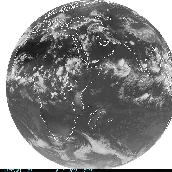
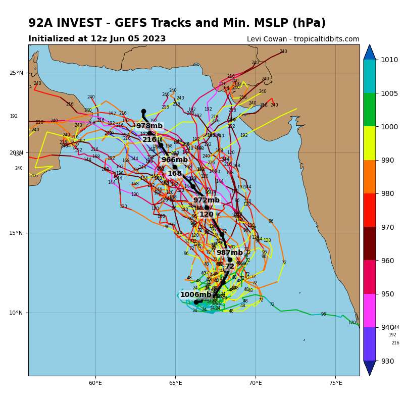
92A INVEST 230605 0000 11.0N 64.0E IO 15 0
ARB: BIPARJOY - Remnants
Moderator: S2k Moderators
ARB: BIPARJOY - Remnants
Last edited by Subtrop on Wed Jun 07, 2023 4:15 am, edited 1 time in total.
0 likes
-
wxman57

- Moderator-Pro Met

- Posts: 23178
- Age: 68
- Joined: Sat Jun 21, 2003 8:06 pm
- Location: Houston, TX (southwest)
Re: ARB: INVEST 92A
Satellite and scatterometer confirm that it's at least a TD bordering on TC. Yet, IMD says "NIL" chance of development through 48 hrs.
0 likes
-
DorkyMcDorkface

- Category 5

- Posts: 1069
- Age: 28
- Joined: Mon Sep 30, 2019 1:32 pm
- Location: Mid-Atlantic
Re: ARB: INVEST 92A
wxman57 wrote:Satellite and scatterometer confirm that it's at least a TD bordering on TC. Yet, IMD says "NIL" chance of development through 48 hrs.
Yeah this is definitely in the process of undergoing TCG. IMD has a tendency to be late on the draw with these things.

0 likes
Please note the thoughts expressed by this account are solely those of the user and are from a hobbyist perspective. For more comprehensive analysis, consult an actual professional meteorologist or meteorological agency.
Floyd 1999 | Isabel 2003 | Hanna 2008 | Irene 2011 | Sandy 2012 | Isaias 2020
-
Iceresistance

- Category 5
- Posts: 9610
- Age: 22
- Joined: Sat Oct 10, 2020 9:45 am
- Location: Tecumseh, OK/Norman, OK
Re: ARB: INVEST 92A
JTWC has a TCFA for this system
0 likes
Bill 2015 & Beta 2020
Winter 2020-2021
All observations are in Tecumseh, OK unless otherwise noted.
Winter posts are focused mainly for Oklahoma & Texas.
Take any of my forecasts with a grain of salt, refer to the NWS, SPC, and NHC for official information
Never say Never with weather! Because ANYTHING is possible!
Winter 2020-2021
All observations are in Tecumseh, OK unless otherwise noted.
Winter posts are focused mainly for Oklahoma & Texas.
Take any of my forecasts with a grain of salt, refer to the NWS, SPC, and NHC for official information
Never say Never with weather! Because ANYTHING is possible!
-
wxman57
- Moderator-Pro Met
- Posts: 23178
- Age: 68
- Joined: Sat Jun 21, 2003 8:06 pm
- Location: Houston, TX (southwest)
Re: ARB: INVEST 92A
India now says it has a moderate chance of becoming a depression within the next 24 hrs and high chance beyond then. Looks like it has been a depression since yesterday and is nearly a TC now. Just need ASCAT hit to confirm.
https://rsmcnewdelhi.imd.gov.in/uploads/archive/47/47_63b479_TROPICAL%20WEATHER%20OUTLOOK%20based%20on%201200%20UTC%20of%2005.06.2023.pdf
https://rsmcnewdelhi.imd.gov.in/uploads/archive/47/47_63b479_TROPICAL%20WEATHER%20OUTLOOK%20based%20on%201200%20UTC%20of%2005.06.2023.pdf
0 likes
-
Sciencerocks
- Category 5
- Posts: 10194
- Age: 40
- Joined: Thu Jul 06, 2017 1:51 am
-
Sciencerocks
- Category 5
- Posts: 10194
- Age: 40
- Joined: Thu Jul 06, 2017 1:51 am
-
Sciencerocks
- Category 5
- Posts: 10194
- Age: 40
- Joined: Thu Jul 06, 2017 1:51 am
-
Yellow Evan

- Professional-Met

- Posts: 16257
- Age: 27
- Joined: Fri Jul 15, 2011 12:48 pm
- Location: Henderson, Nevada/Honolulu, HI
- Contact:
Re: ARB: INVEST 92A
Clear TC that may be developing an inner core. Intensity forecast with this is in limbo after the short term. Upper level flow is generally divergent but depending on how fast this lifts north and how west this tracks, it might not be aligned with motion, which would greately worsen the shear already amplified by reverse (southwesterly) monsoonal flow near the surface.
3 likes
-
Sciencerocks
- Category 5
- Posts: 10194
- Age: 40
- Joined: Thu Jul 06, 2017 1:51 am
Re: ARB: INVEST 92A
0 likes
-
Hurricane2022

- Category 5
- Posts: 2096
- Joined: Tue Aug 23, 2022 11:38 pm
- Location: Araçatuba, Brazil
Re: ARB: INVEST 92A
This rapid development of 92A (future Biparjoy) reminds me very well of Cyclone Gati '20. When JTWC classified it as a category 3, IMD still was thinking that it was a Deep Depression.
0 likes
Sorry for the bad English sometimes...!
For reliable and detailed information for any meteorological phenomenon, please consult the National Hurricane Center, Joint Typhoon Warning Center , or your local Meteo Center.
--------
ECCE OMNIA NOVA FACIAM (Ap 21,5).
For reliable and detailed information for any meteorological phenomenon, please consult the National Hurricane Center, Joint Typhoon Warning Center , or your local Meteo Center.
--------
ECCE OMNIA NOVA FACIAM (Ap 21,5).
-
Sciencerocks
- Category 5
- Posts: 10194
- Age: 40
- Joined: Thu Jul 06, 2017 1:51 am


-
cycloneye

- Admin

- Posts: 149843
- Age: 69
- Joined: Thu Oct 10, 2002 10:54 am
- Location: San Juan, Puerto Rico
Re: ARB: Depression

0 likes
Visit the Caribbean-Central America Weather Thread where you can find at first post web cams,radars
and observations from Caribbean basin members Click Here
and observations from Caribbean basin members Click Here
-
Sciencerocks
- Category 5
- Posts: 10194
- Age: 40
- Joined: Thu Jul 06, 2017 1:51 am
-
Sciencerocks
- Category 5
- Posts: 10194
- Age: 40
- Joined: Thu Jul 06, 2017 1:51 am
-
cycloneye
- Admin
- Posts: 149843
- Age: 69
- Joined: Thu Oct 10, 2002 10:54 am
- Location: San Juan, Puerto Rico
Re: ARB: BIPARJOY - Severe Cyclonic Storm

0 likes
Visit the Caribbean-Central America Weather Thread where you can find at first post web cams,radars
and observations from Caribbean basin members Click Here
and observations from Caribbean basin members Click Here
-
cycloneye
- Admin
- Posts: 149843
- Age: 69
- Joined: Thu Oct 10, 2002 10:54 am
- Location: San Juan, Puerto Rico
Re: ARB: BIPARJOY - Cyclonic Storm
0 likes
Visit the Caribbean-Central America Weather Thread where you can find at first post web cams,radars
and observations from Caribbean basin members Click Here
and observations from Caribbean basin members Click Here
-
Iceresistance
- Category 5
- Posts: 9610
- Age: 22
- Joined: Sat Oct 10, 2020 9:45 am
- Location: Tecumseh, OK/Norman, OK
Re: ARB: BIPARJOY - Cyclonic Storm
What is this name??

0 likes
Bill 2015 & Beta 2020
Winter 2020-2021
All observations are in Tecumseh, OK unless otherwise noted.
Winter posts are focused mainly for Oklahoma & Texas.
Take any of my forecasts with a grain of salt, refer to the NWS, SPC, and NHC for official information
Never say Never with weather! Because ANYTHING is possible!
Winter 2020-2021
All observations are in Tecumseh, OK unless otherwise noted.
Winter posts are focused mainly for Oklahoma & Texas.
Take any of my forecasts with a grain of salt, refer to the NWS, SPC, and NHC for official information
Never say Never with weather! Because ANYTHING is possible!
Who is online
Users browsing this forum: No registered users and 37 guests