https://ftp.nhc.noaa.gov/atcf/btk/bep942023.dat
CPAC: CALVIN - Post-Tropical - Discussion
Moderator: S2k Moderators
CPAC: CALVIN - Post-Tropical - Discussion
EP, 94, 2023071006, , BEST, 0, 103N, 977W, 20, 1009, DB, 34, NEQ, 0, 0, 0, 0, 1011, 200, 90, 0, 0, E, 0, , 0, 0, INVEST, S, 0, , 0, 0, 0, 0, genesis-num, 007, SPAWNINVEST, ep772023 to ep942023,
https://ftp.nhc.noaa.gov/atcf/btk/bep942023.dat
Last edited by Subtrop on Wed Jul 12, 2023 3:25 am, edited 1 time in total.
0 likes
- cycloneye
- Admin

- Posts: 149711
- Age: 69
- Joined: Thu Oct 10, 2002 10:54 am
- Location: San Juan, Puerto Rico
Re: EPAC: INVEST 94E - Discussion
Hopefully, this one is not like 93E and develops into a good longtracker.


0 likes
Visit the Caribbean-Central America Weather Thread where you can find at first post web cams,radars
and observations from Caribbean basin members Click Here
and observations from Caribbean basin members Click Here
- Kingarabian
- S2K Supporter

- Posts: 16379
- Joined: Sat Aug 08, 2009 3:06 am
- Location: Honolulu, Hawaii
Re: EPAC: INVEST 94E - Discussion
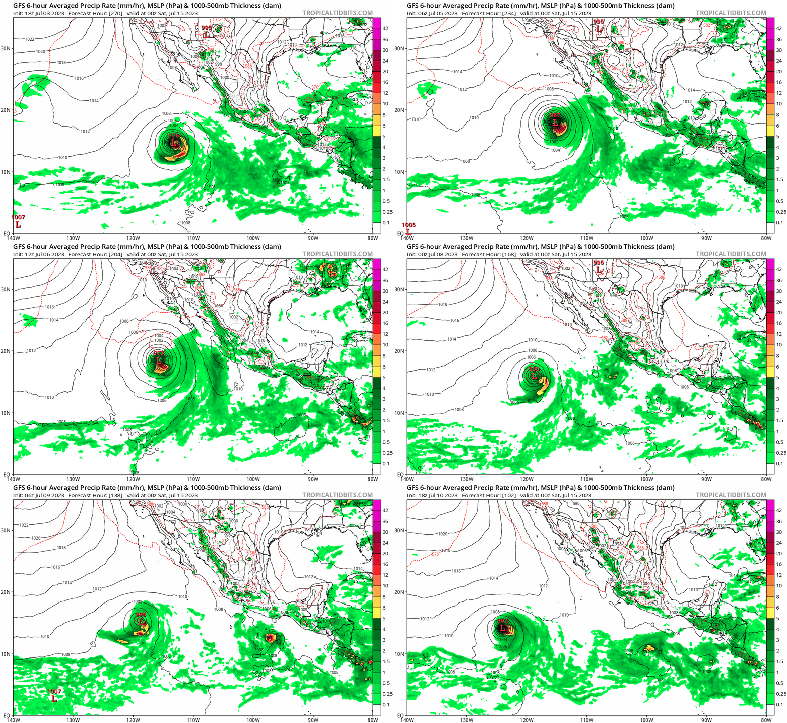
CMC and Euro still make a hurricane out of it. GFS has really backed off on intensity though.
Last edited by Kingarabian on Mon Jul 10, 2023 7:41 am, edited 1 time in total.
0 likes
RIP Kobe Bryant
- cycloneye
- Admin

- Posts: 149711
- Age: 69
- Joined: Thu Oct 10, 2002 10:54 am
- Location: San Juan, Puerto Rico
Re: EPAC: INVEST 94E - Discussion
Offshore of Southern Mexico (EP94):
Shower and thunderstorm activity is gradually becoming better
organized in association with an area of low pressure located
a few hundred miles south of the southern coast of Mexico.
Environmental conditions are forecast to be conducive for additional
development during the next several days, and a tropical depression
is likely to form during the middle to latter part of this week.
The system is expected to move westward to west-northwestward,
remaining well offshore of the coast of Mexico.
* Formation chance through 48 hours...medium...50 percent.
* Formation chance through 7 days...high...90 percent.
0 likes
Visit the Caribbean-Central America Weather Thread where you can find at first post web cams,radars
and observations from Caribbean basin members Click Here
and observations from Caribbean basin members Click Here
- cycloneye
- Admin

- Posts: 149711
- Age: 69
- Joined: Thu Oct 10, 2002 10:54 am
- Location: San Juan, Puerto Rico
Re: EPAC: INVEST 94E - Discussion
EP, 94, 2023071012, , BEST, 0, 102N, 989W, 20, 1008, DB
0 likes
Visit the Caribbean-Central America Weather Thread where you can find at first post web cams,radars
and observations from Caribbean basin members Click Here
and observations from Caribbean basin members Click Here
-
Sciencerocks
- Category 5

- Posts: 10193
- Age: 40
- Joined: Thu Jul 06, 2017 1:51 am
- cycloneye
- Admin

- Posts: 149711
- Age: 69
- Joined: Thu Oct 10, 2002 10:54 am
- Location: San Juan, Puerto Rico
Re: EPAC: INVEST 94E - Discussion
Kingarabian 12z ICON and GFS are a little bit stronger.


0 likes
Visit the Caribbean-Central America Weather Thread where you can find at first post web cams,radars
and observations from Caribbean basin members Click Here
and observations from Caribbean basin members Click Here
Re: EPAC: INVEST 94E - Discussion
Not much support of this becoming a hurricane other than from the usual aggressive HWRF & HMON.
0 likes
- cycloneye
- Admin

- Posts: 149711
- Age: 69
- Joined: Thu Oct 10, 2002 10:54 am
- Location: San Juan, Puerto Rico
Re: EPAC: INVEST 94E - Discussion
Tropical Weather Outlook
NWS National Hurricane Center Miami FL
1100 AM PDT Mon Jul 10 2023
For the eastern North Pacific...east of 140 degrees west longitude:
Offshore of Southern Mexico (EP94):
Shower and thunderstorm activity is becoming better
organized in association with an area of low pressure located
a few hundred miles south of the southern coast of Mexico.
Environmental conditions are forecast to be conducive for additional
development, and a tropical depression is likely to form during the
next couple of days. The system is expected to move westward to
west-northwestward, remaining well offshore of the coast of Mexico.
* Formation chance through 48 hours...high...60 percent.
* Formation chance through 7 days...high...90 percent.
$$
Forecaster Kelly/Cangialosi
0 likes
Visit the Caribbean-Central America Weather Thread where you can find at first post web cams,radars
and observations from Caribbean basin members Click Here
and observations from Caribbean basin members Click Here
- cycloneye
- Admin

- Posts: 149711
- Age: 69
- Joined: Thu Oct 10, 2002 10:54 am
- Location: San Juan, Puerto Rico
Re: EPAC: INVEST 94E - Discussion
Kingarabian Calvin is there.


0 likes
Visit the Caribbean-Central America Weather Thread where you can find at first post web cams,radars
and observations from Caribbean basin members Click Here
and observations from Caribbean basin members Click Here
-
Sciencerocks
- Category 5

- Posts: 10193
- Age: 40
- Joined: Thu Jul 06, 2017 1:51 am
- ElectricStorm
- Category 5

- Posts: 5155
- Age: 25
- Joined: Tue Aug 13, 2019 11:23 pm
- Location: Norman, OK
Re: EPAC: INVEST 94E - Discussion
This also seems pretty broad and is likely a ways away from developing. However this should track more west than 93E is so I think it will have a much better chance to develop. Should see Calvin and hopefully we can get a good hurricane out of this, but I'm skeptical.
0 likes
B.S Meteorology, University of Oklahoma '25
Please refer to the NHC, NWS, or SPC for official information.
Please refer to the NHC, NWS, or SPC for official information.
- cycloneye
- Admin

- Posts: 149711
- Age: 69
- Joined: Thu Oct 10, 2002 10:54 am
- Location: San Juan, Puerto Rico
Re: EPAC: INVEST 94E - Discussion
Also Euro, but weakens to TD at that point.

0 likes
Visit the Caribbean-Central America Weather Thread where you can find at first post web cams,radars
and observations from Caribbean basin members Click Here
and observations from Caribbean basin members Click Here
- Yellow Evan
- Professional-Met

- Posts: 16257
- Age: 27
- Joined: Fri Jul 15, 2011 12:48 pm
- Location: Henderson, Nevada/Honolulu, HI
- Contact:
Re: EPAC: INVEST 94E - Discussion


Upper and middle environment is mostly favorable after 36 hours. SSTs gradually drop off but should remain above 26C for about 5 days. System is compact so dry air intrusions less of an issue. We’ve seen similar setups before be grossly underestimated by global models prior to TCG.
1 likes
- Kingarabian
- S2K Supporter

- Posts: 16379
- Joined: Sat Aug 08, 2009 3:06 am
- Location: Honolulu, Hawaii
Re: EPAC: INVEST 94E - Discussion
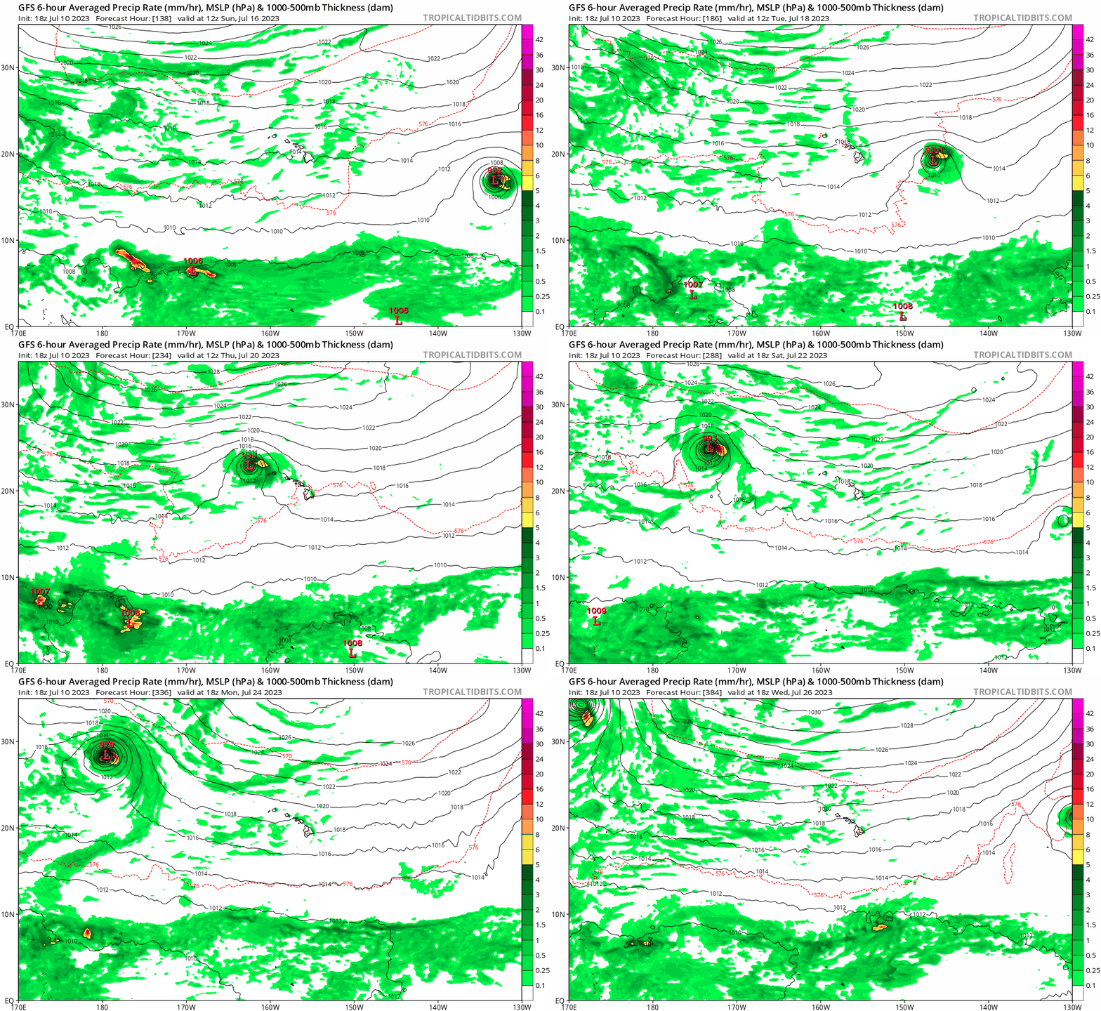
Waters east of Hawaii are cooler compared to 2014-2018. Looks like any significant impacts need to come from the south.
1 likes
RIP Kobe Bryant
- Yellow Evan
- Professional-Met

- Posts: 16257
- Age: 27
- Joined: Fri Jul 15, 2011 12:48 pm
- Location: Henderson, Nevada/Honolulu, HI
- Contact:
Re: EPAC: INVEST 94E - Discussion
Both GFS and ECMWF have a favorable TUTT interaction that could allow for it to retain deep convection for longer than one would expect but it is still dubious outflow from a TC over 23-24C SSTs will destroy the TUTT easily.


Last edited by Yellow Evan on Mon Jul 10, 2023 6:54 pm, edited 1 time in total.
0 likes
- cycloneye
- Admin

- Posts: 149711
- Age: 69
- Joined: Thu Oct 10, 2002 10:54 am
- Location: San Juan, Puerto Rico
Re: EPAC: INVEST 94E - Discussion
Tropical Weather Outlook
NWS National Hurricane Center Miami FL
500 PM PDT Mon Jul 10 2023
For the eastern North Pacific...east of 140 degrees west longitude:
1. Offshore of Southern Mexico (EP94):
Shower and thunderstorm activity is becoming better organized in
association with an area of low pressure located a few hundred miles
south of the southern coast of Mexico. Environmental conditions
appear conducive for additional development, and a tropical
depression is likely to form during the next couple of days. The
system is expected to move westward to west-northwestward over the
next several days, remaining well offshore of the coast of Mexico.
* Formation chance through 48 hours...high...70 percent.
* Formation chance through 7 days...high...90 percent.
Forecaster Beven
0 likes
Visit the Caribbean-Central America Weather Thread where you can find at first post web cams,radars
and observations from Caribbean basin members Click Here
and observations from Caribbean basin members Click Here
- Blown Away
- S2K Supporter

- Posts: 10253
- Joined: Wed May 26, 2004 6:17 am
2023 EPAC Season
1 likes
Hurricane Eye Experience: David 79, Irene 99, Frances 04, Jeanne 04, Wilma 05… Hurricane Brush Experience: Andrew 92, Erin 95, Floyd 99, Matthew 16, Irma 17, Ian 22, Nicole 22…
Re: EPAC: INVEST 94E - Discussion
So the GFS was initially aggressive with this invest becoming a long-track major, then went quiet since 0z 7/8 to the point of almost not showing a hurricane... And now there are two runs in a row with a major again.
Any idea why?

Any idea why?

1 likes
TC naming lists: retirements and intensity
Most aggressive Advisory #1's in North Atlantic (cr. kevin for starting the list)
Most aggressive Advisory #1's in North Atlantic (cr. kevin for starting the list)
Who is online
Users browsing this forum: No registered users and 56 guests


