ATL: FRANKLIN - Post-Tropical - Discussion

Moderator: S2k Moderators

Message
Author
User avatar
senorpepr
Military Met/Moderator
Posts: 12542
Age: 41
Joined: Fri Aug 22, 2003 9:22 pm
Location: Mackenbach, Germany
Contact:

ATL: FRANKLIN - Post-Tropical - Discussion

#1 Postby senorpepr » Sat Aug 19, 2023 2:04 am

Code: Select all

AL, 90, 2023081906,   , BEST,   0, 120N,  575W,  20, 1007, DB,  34, NEQ,    0,    0,    0,    0, 1008,  150,  90,   0,   0,   L,   0,    ,   0,   0,     INVEST, S,  0,    ,    0,    0,    0,    0, genesis-num, 020, SPAWNINVEST, al732023 to al902023,


https://ftp.nhc.noaa.gov/atcf/btk/bal902023.dat

New invest tagged for the disturbance closest to the Lesser Antilles.
4 likes   

User avatar
Hurricane2022
Category 4
Category 4
Posts: 946
Joined: Tue Aug 23, 2022 11:38 pm
Location: Araçatuba, Brazil

Re: ATL: INVEST 90L - Discussion

#2 Postby Hurricane2022 » Sat Aug 19, 2023 2:09 am

After 84 years!! Hurricane Emily/Franklin is coming!!!
3 likes   
Sorry for the bad English sometimes...!
For reliable and detailed information for any meteorological phenomenon, please consult the National Hurricane Center, Joint Typhoon Warning Center , or your local Meteo Center.

--------

Una cvm Christo, pro Christo, et in Christo. Sit nomen Domini benedictvm.

User avatar
Landy
Category 1
Category 1
Posts: 310
Joined: Wed Aug 11, 2021 7:43 pm
Location: Port Orange, FL

Re: ATL: INVEST 90L - Discussion

#3 Postby Landy » Sat Aug 19, 2023 2:21 am

Image
2 likes   

User avatar
REDHurricane
Tropical Storm
Tropical Storm
Posts: 207
Age: 26
Joined: Sun Jul 03, 2022 2:36 pm
Location: Northeast Pacific Ocean

Re: ATL: INVEST 90L - Discussion

#4 Postby REDHurricane » Sat Aug 19, 2023 2:53 am

0 likes   

User avatar
ouragans
Category 1
Category 1
Posts: 466
Age: 52
Joined: Sun Jun 12, 2011 12:09 pm
Location: Abymes, Guadeloupe F.W.I
Contact:

Re: ATL: INVEST 90L - Discussion

#5 Postby ouragans » Sat Aug 19, 2023 4:17 am

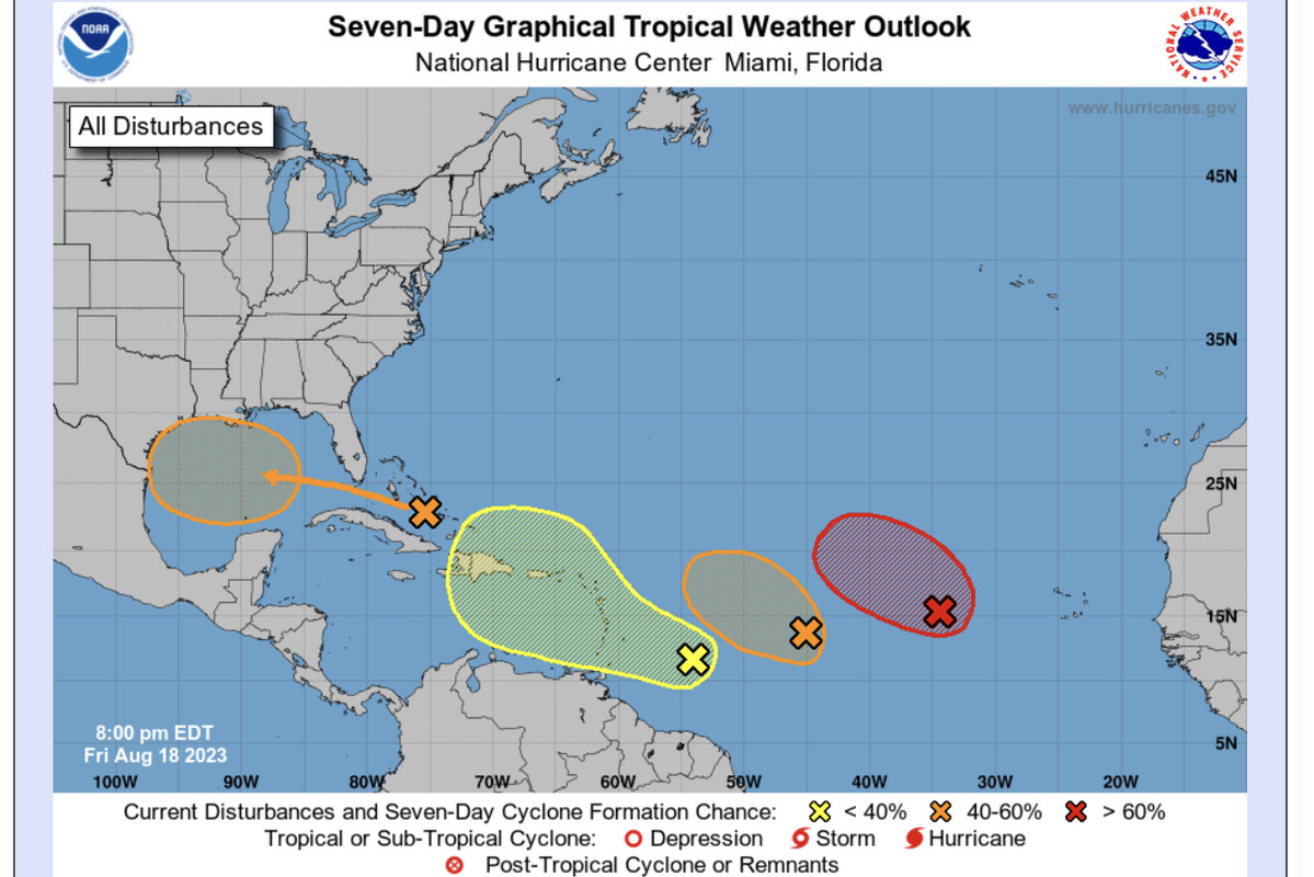
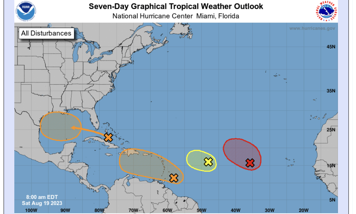
3. East-Southeast of the Lesser Antilles:
A tropical wave located a few hundred miles to the east-southeast of
the Lesser Antilles is producing some disorganized showers and
thunderstorms. Some gradual development of this system is possible
this weekend and during the early and middle parts of next week
while it moves westward to west-northwestward at 10 to 15 mph,
across the Lesser Antilles and over the eastern and central
Caribbean Sea.
* Formation chance through 48 hours...low...10 percent.
* Formation chance through 7 days...low...30 percent.

Image
0 likes   
Personal forecast disclaimer
This post is a personal point of view, not an information. Please refer to official statements for life-threatening decisions.

David '79, Frederic '79, Hugo '89, Iris, Luis & Marilyn '95, Georges '98, Lenny '99, Dean '07, Irma '17, Maria '17, Fiona '22, Philippe '23, Tammy '23
16°13'33.3,"6N -61°36'39.5"W

User avatar
NDG
S2K Supporter
S2K Supporter
Posts: 14934
Joined: Sun Jul 09, 2006 10:14 pm
Location: Orlando, FL

Re: ATL: INVEST 90L - Discussion

#6 Postby NDG » Sat Aug 19, 2023 6:32 am

Nice vorticity seen with it on radar.

Image
2 likes   

User avatar
NDG
S2K Supporter
S2K Supporter
Posts: 14934
Joined: Sun Jul 09, 2006 10:14 pm
Location: Orlando, FL

Re: ATL: INVEST 90L - Discussion

#7 Postby NDG » Sat Aug 19, 2023 6:44 am

Barbados reports 1005mb surface pressure, down 3 mb from 24 hrs ago, 6 mb from 48 hrs ago.

https://www.weather.gov/wrh/timeseries? ... B&hours=72
0 likes   

User avatar
cycloneye
Admin
Admin
Posts: 139352
Age: 67
Joined: Thu Oct 10, 2002 10:54 am
Location: San Juan, Puerto Rico

Re: ATL: INVEST 90L - Discussion

#8 Postby cycloneye » Sat Aug 19, 2023 6:53 am

East-Southeast of the Lesser Antilles (AL90):
A tropical wave located just east of the Windward Islands is
producing disorganized showers and thunderstorms. Some gradual
development of this system is possible and a tropical depression
could form during the early and middle parts of next week while it
moves westward to west-northwestward at 10 to 15 mph, across the
Lesser Antilles and over the eastern and central Caribbean Sea.
* Formation chance through 48 hours...low...20 percent.
* Formation chance through 7 days...medium...40 percent.
1 likes   
Visit the Caribbean-Central America Weather Thread where you can find at first post web cams,radars
and observations from Caribbean basin members Click Here

User avatar
Blown Away
S2K Supporter
S2K Supporter
Posts: 9867
Joined: Wed May 26, 2004 6:17 am

Re: ATL: INVEST 90L - Discussion

#9 Postby Blown Away » Sat Aug 19, 2023 7:11 am

Image
Old

Image
Current 8am??

GFS/Euro continue driving 90L through Hispaniola, but the NHC appears to think 90L goes farther W in the Caribbean based on the adjustments to their 7 day cone??
0 likes   
Hurricane Eye Experience: David 79, Irene 99, Frances 04, Jeanne 04, Wilma 05... EYE COMING MY WAY IN 2024…
Hurricane Brush Experience: Andrew 92, Erin 95, Floyd 99, Matthew 16, Irma 17, Ian 22, Nicole 22…

User avatar
NDG
S2K Supporter
S2K Supporter
Posts: 14934
Joined: Sun Jul 09, 2006 10:14 pm
Location: Orlando, FL

Re: ATL: INVEST 90L - Discussion

#10 Postby NDG » Sat Aug 19, 2023 7:27 am

Best looking invest in the Atlantic this morning.
Props to the Euro for sniffing this out a couple of days ago.

Image
5 likes   

tolakram
Admin
Admin
Posts: 19171
Age: 60
Joined: Sun Aug 27, 2006 8:23 pm
Location: Florence, KY (name is Mark)

Re: ATL: INVEST 90L - Discussion

#11 Postby tolakram » Sat Aug 19, 2023 7:40 am

Popcorn convection and some apparent banding, but hard to tell what's underneath.

Image
1 likes   
M a r k
- - - - -
Join us in chat: Storm2K Chatroom Invite. Android and IOS apps also available.

The posts in this forum are NOT official forecasts and should not be used as such. Posts are NOT endorsed by any professional institution or STORM2K.org. For official information and forecasts, please refer to NHC and NWS products.

User avatar
GCANE
S2K Supporter
S2K Supporter
Posts: 10787
Joined: Mon Oct 22, 2007 8:03 am

Re: ATL: INVEST 90L - Discussion

#12 Postby GCANE » Sat Aug 19, 2023 7:56 am

Watching this one closely.
Carib has overall more high CAPE air than currently in the GoM.
Global models may be underestimating at this point.
2 likes   

tolakram
Admin
Admin
Posts: 19171
Age: 60
Joined: Sun Aug 27, 2006 8:23 pm
Location: Florence, KY (name is Mark)

Re: ATL: INVEST 90L - Discussion

#13 Postby tolakram » Sat Aug 19, 2023 8:09 am

1 likes   
M a r k
- - - - -
Join us in chat: Storm2K Chatroom Invite. Android and IOS apps also available.

The posts in this forum are NOT official forecasts and should not be used as such. Posts are NOT endorsed by any professional institution or STORM2K.org. For official information and forecasts, please refer to NHC and NWS products.

jlauderdal
S2K Supporter
S2K Supporter
Posts: 6776
Joined: Wed May 19, 2004 5:46 am
Location: NE Fort Lauderdale
Contact:

Re: ATL: INVEST 90L - Discussion

#14 Postby jlauderdal » Sat Aug 19, 2023 8:15 am


How many systems in that area have we seen that look awesome on IR but are really nothing more than a sharp trough, we need to know whats happening at the surface on up. There was one a couple of years ago that blew through the islands that looked mean on IR, had 50+ wind but no LLC
3 likes   

User avatar
cycloneye
Admin
Admin
Posts: 139352
Age: 67
Joined: Thu Oct 10, 2002 10:54 am
Location: San Juan, Puerto Rico

Re: ATL: INVEST 90L - Discussion

#15 Postby cycloneye » Sat Aug 19, 2023 8:17 am

AL, 90, 2023081912, , BEST, 0, 122N, 588W, 20, 1007, DB
1 likes   
Visit the Caribbean-Central America Weather Thread where you can find at first post web cams,radars
and observations from Caribbean basin members Click Here

User avatar
boca
Category 5
Category 5
Posts: 6306
Age: 59
Joined: Mon Dec 15, 2003 8:49 am
Location: Boca Raton,FL

Re: ATL: INVEST 90L - Discussion

#16 Postby boca » Sat Aug 19, 2023 8:23 am

If this goes further west in the Caribbean than currently forecast it will sure make for an interesting week ahead.
1 likes   

User avatar
tropicwatch
Category 5
Category 5
Posts: 3205
Age: 60
Joined: Sat Jun 02, 2007 10:01 am
Location: Panama City Florida
Contact:

Re: ATL: INVEST 90L - Discussion

#17 Postby tropicwatch » Sat Aug 19, 2023 8:24 am

925mb vorticity increasing nicely this morning.

Image
0 likes   
Tropicwatch


Agnes 72', Eloise 75, Elena 85', Kate 85', Charley 86', Florence 88', Beryl 94', Dean 95', Erin 95', Opal 95', Earl 98', Georges 98', Ivan 2004', Arlene 2005', Dennis 2005', Ida 2009' Debby 2012' Irma 2017' Michael 2018'

User avatar
cycloneye
Admin
Admin
Posts: 139352
Age: 67
Joined: Thu Oct 10, 2002 10:54 am
Location: San Juan, Puerto Rico

Re: ATL: INVEST 90L - Discussion

#18 Postby cycloneye » Sat Aug 19, 2023 8:43 am

cycloneye wrote:
AL, 90, 2023081912, , BEST, 0, 122N, 588W, 20, 1007, DB


A little change.

AL, 90, 2023081912, , BEST, 0, 120N, 588W, 25, 1007, DB
2 likes   
Visit the Caribbean-Central America Weather Thread where you can find at first post web cams,radars
and observations from Caribbean basin members Click Here

User avatar
GCANE
S2K Supporter
S2K Supporter
Posts: 10787
Joined: Mon Oct 22, 2007 8:03 am

Re: ATL: INVEST 90L - Discussion

#19 Postby GCANE » Sat Aug 19, 2023 8:45 am

Looks like if strengthens in the east Carib, Hispaniola at risk.
Weak development and possibly pushing into the west Carib.
0 likes   

tolakram
Admin
Admin
Posts: 19171
Age: 60
Joined: Sun Aug 27, 2006 8:23 pm
Location: Florence, KY (name is Mark)

Re: ATL: INVEST 90L - Discussion

#20 Postby tolakram » Sat Aug 19, 2023 9:09 am

2 likes   
M a r k
- - - - -
Join us in chat: Storm2K Chatroom Invite. Android and IOS apps also available.

The posts in this forum are NOT official forecasts and should not be used as such. Posts are NOT endorsed by any professional institution or STORM2K.org. For official information and forecasts, please refer to NHC and NWS products.


Return to “2023”

Who is online

Users browsing this forum: No registered users and 10 guests