ATL: LEE - Models
Moderator: S2k Moderators

Re: ATL: INVEST 95L - Models
For the model runs that show a northern bend as it reaches PR, what are they picking up on that makes the system take such a drastic turn?
0 likes
-
Meteorcane

- Category 2

- Posts: 541
- Joined: Thu Jul 21, 2011 6:49 am
- Location: North Platte Nebraska
Re: ATL: INVEST 95L - Models
Senobia wrote:For the model runs that show a northern bend as it reaches PR, what are they picking up on that makes the system take such a drastic turn?
I assume you mean the turn later in the forecast east of the Bahamas... that is caused by a fairly high amplitude trough (at least for this time of year) which moves into the eastern US/Western Atlantic early next week. This erodes the subtropical ridge to the north of the system which had kept it on a WNW heading. This is the EPS (European ensemble) 500mb mean height anomalies map for the day 6-10 forecast, you can see the blue (negative) height anomalies indicating the forecasted trough digging southward early next week (likely in response to a shortwave digging in from Canada, but this can't be explicitly inferred from an ensemble mean height field) which in turn cause the red (positive) height anomalies representing the oceanic ridge to erode away, providing a weakness for 95L to lift northward... and then likely turn NE later in the run given the troughs amplitude.
Will this pattern happen exactly as the Euro ensemble shows... probably not exactly but this general solution with some form of troughing near the east coat/west Atlantic does look like the most likely solution for early next week. There have a been deterministic runs of say the GFS would have showed a much less amplified pattern which would maybe open the door for a "ridge bridge" solution where the Oceanic ridge connects with the SW US ridge shunting the storm-track further north, which would be more concerning for the east coast... but this is definitely an outlier solution and the trough seems more likely.

2 likes
Re: ATL: INVEST 95L - Models
Senobia wrote:For the model runs that show a northern bend as it reaches PR, what are they picking up on that makes the system take such a drastic turn?
troughing/weakness in the west altantic which doesn't budge, it's there run after run
edit: 12z GFS trending towards euro now, misses islands entirely
0 likes
-
gatorcane

- S2K Supporter

- Posts: 23499
- Age: 46
- Joined: Sun Mar 13, 2005 3:54 pm
- Location: Boca Raton, FL
Re: ATL: INVEST 95L - Models
The 12Z GFS shifted north and is stronger now taking the storm north of the islands and is close to the 00Z ECMWF and TVCN. The CMC also shifted north too and both models like the ECMWF turn a potentially powerful hurricane north into a weakness over the SW Atlantic next weekend with the CMC furthest west with the turn and ECMWF furthest east. 12Z models so far good news for the islands.
12Z GFS loop:
12Z GFS loop:
Last edited by gatorcane on Sun Sep 03, 2023 11:29 am, edited 4 times in total.
0 likes
-
Hypercane_Kyle

- Category 5

- Posts: 2900
- Joined: Sat Mar 07, 2015 7:58 pm
- Location: Cape Canaveral, FL
Re: ATL: INVEST 95L - Models
gatorcane wrote:The 12Z GFS shifted north and is stronger now taking the storm north of the islands and is close to the 00Z ECMWF and TVCN. The CMC also shifted north too and both models like the Euro turn a potentially powerful hurricane north into a weakness over the SW Atlantic next weekend. 12Z models so far good news for the islands.
Yeah, obviously too early to know with high certainty, but I am feeling increasingly confident this system will outright miss all landmass and go safely out to sea. Similar to Sam in 2021.
0 likes
My posts are my own personal opinion, defer to the National Hurricane Center (NHC) and other NOAA products for decision making during hurricane season.
-
cheezyWXguy

- Category 5
- Posts: 5555
- Joined: Mon Feb 13, 2006 12:29 am
- Location: Dallas, TX
Re: ATL: INVEST 95L - Models
That bend back to the west at day 10 on the 12z gfs is interesting. The trough that swept it out on previous runs lifts out too quickly to take 95L with it. Still don’t think it reaches the east coast this run as the next trough will likely pick it up, but this is something we’ll need to watch for as time goes on.
0 likes
-
SFLcane

- S2K Supporter
- Posts: 9617
- Age: 46
- Joined: Sat Jun 05, 2010 1:44 pm
- Location: Lake Worth Florida
Re: ATL: INVEST 95L - Models
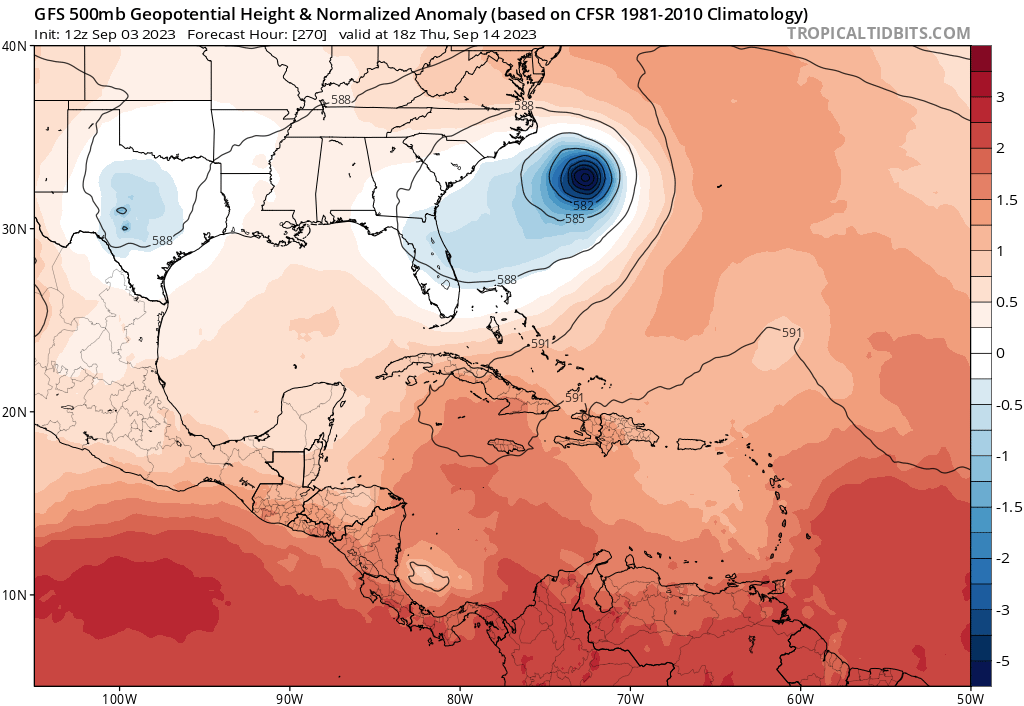
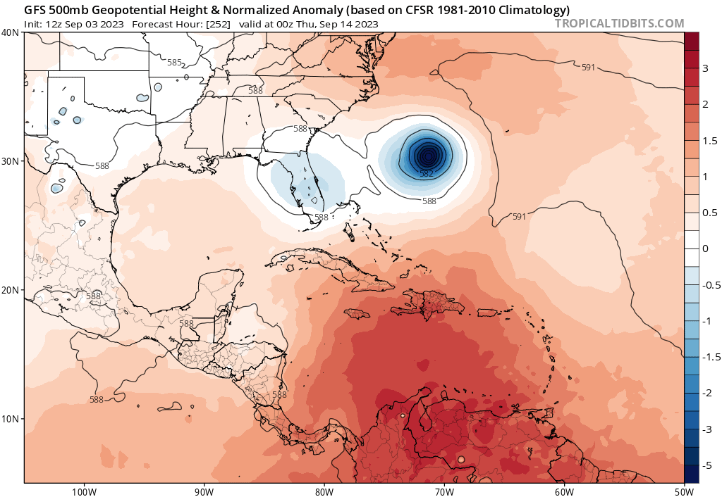
Well this is interesting....just about anything is possible this far out.
Last edited by SFLcane on Sun Sep 03, 2023 11:55 am, edited 1 time in total.
1 likes
-
AutoPenalti
- Category 5
- Posts: 3949
- Age: 27
- Joined: Mon Aug 17, 2015 4:16 pm
- Location: Ft. Lauderdale, Florida
Re: ATL: INVEST 95L - Models
SFLcane wrote:Well this is interesting....just about anything is possible this far out.
https://i.postimg.cc/Y9r2XbYF/hjhjhjhjhj.png
That doesn’t scream OTS to me.
1 likes
The posts in this forum are NOT official forecasts and should not be used as such. They are just the opinion of the poster and may or may not be backed by sound meteorological data. They are NOT endorsed by any professional institution or STORM2K. For official information, please refer to products from the NHC and NWS.
Model Runs Cheat Sheet:
GFS (5:30 AM/PM, 11:30 AM/PM)
HWRF, GFDL, UKMET, NAVGEM (6:30-8:00 AM/PM, 12:30-2:00 AM/PM)
ECMWF (1:45 AM/PM)
TCVN is a weighted averaged
-
SFLcane
- S2K Supporter
- Posts: 9617
- Age: 46
- Joined: Sat Jun 05, 2010 1:44 pm
- Location: Lake Worth Florida
Re: ATL: INVEST 95L - Models
AutoPenalti wrote:SFLcane wrote:Well this is interesting....just about anything is possible this far out.
https://i.postimg.cc/Y9r2XbYF/hjhjhjhjhj.png
That doesn’t scream OTS to me.
new trend ? we shall see
0 likes
-
jlauderdal
- S2K Supporter
- Posts: 6776
- Joined: Wed May 19, 2004 5:46 am
- Location: NE Fort Lauderdale
- Contact:
Re: RE: Re: ATL: INVEST 95L - Models
Medium to long range modeling struggling with the ridge, no way.SFLcane wrote:AutoPenalti wrote:SFLcane wrote:Well this is interesting....just about anything is possible this far out.
https://i.postimg.cc/Y9r2XbYF/hjhjhjhjhj.png
That doesn’t scream OTS to me.
new trend ? we shall see
2 likes

Re: ATL: INVEST 95L - Models
The 12z hurricane models develop 95L at 37-38W (HWRF), 40-41W (HMON), 44-45W (HAFS-A), and 38-39W (HAFS-B), respectively. That’s faster and further east than many runs from yesterday.
Last edited by aspen on Sun Sep 03, 2023 12:52 pm, edited 1 time in total.
0 likes
Irene '11 Sandy '12 Hermine '16 5/15/2018 Derecho Fay '20 Isaias '20 Elsa '21 Henri '21 Ida '21
I am only a meteorology enthusiast who knows a decent amount about tropical cyclones. Look to the professional mets, the NHC, or your local weather office for the best information.
I am only a meteorology enthusiast who knows a decent amount about tropical cyclones. Look to the professional mets, the NHC, or your local weather office for the best information.
-
Blown Away

- S2K Supporter
- Posts: 9864
- Joined: Wed May 26, 2004 6:17 am
Re: RE: Re: ATL: INVEST 95L - Models
jlauderdal wrote:Medium to long range modeling struggling with the ridge, no way.SFLcane wrote:AutoPenalti wrote:That doesn’t scream OTS to me.
new trend ? we shall see
HP around, finally getting nice breezes off the ocean. Slight season changes.
0 likes
Hurricane Eye Experience: David 79, Irene 99, Frances 04, Jeanne 04, Wilma 05...
Hurricane Brush Experience: Andrew 92, Erin 95, Floyd 99, Matthew 16, Irma 17, Ian 22, Nicole 22…
Hurricane Brush Experience: Andrew 92, Erin 95, Floyd 99, Matthew 16, Irma 17, Ian 22, Nicole 22…
-
jlauderdal
- S2K Supporter
- Posts: 6776
- Joined: Wed May 19, 2004 5:46 am
- Location: NE Fort Lauderdale
- Contact:
Re: RE: Re: RE: Re: ATL: INVEST 95L - Models
Felt like a windchill this morning on the bike ride, 70 dp the next few days, I would take 90-95 with a 70 dew 365 days a year.Blown Away wrote:jlauderdal wrote:Medium to long range modeling struggling with the ridge, no way.SFLcane wrote:
new trend ? we shall see
HP around, finally getting nice breezes off the ocean. Slight season changes.
Odds are for a recurve but lets give it another few cycles and see if things settle down, the leadup to our storm last week didnt have very consistent modeling.
I ran my generator yesterday for its monthly 20 min run...long way to go for Floridians.
2 likes
-
Spacecoast

- Category 2
- Posts: 687
- Joined: Thu Aug 31, 2017 2:03 pm

-
SFLcane
- S2K Supporter
- Posts: 9617
- Age: 46
- Joined: Sat Jun 05, 2010 1:44 pm
- Location: Lake Worth Florida
Re: RE: Re: RE: Re: ATL: INVEST 95L - Models
jlauderdal wrote:Felt like a windchill this morning on the bike ride, 70 dp the next few days, I would take 90-95 with a 70 dew 365 days a year.Blown Away wrote:jlauderdal wrote:Medium to long range modeling struggling with the ridge, no way.
HP around, finally getting nice breezes off the ocean. Slight season changes.
Odds are for a recurve but lets give it another few cycles and see if things settle down, the leadup to our storm last week didnt have very consistent modeling.
I ran my generator yesterday for its monthly 20 min run...long way to go for Floridians.
0 likes

Re: ATL: INVEST 95L - Models
AutoPenalti wrote:SFLcane wrote:Well this is interesting....just about anything is possible this far out.
https://i.postimg.cc/Y9r2XbYF/hjhjhjhjhj.png
That doesn’t scream OTS to me.
270 hours might not even be 95L
We were looking at a ridge decision last night at 168 hours near Puerto Rico.
0 likes
-
floridasun
- Tropical Storm

- Posts: 107
- Joined: Tue Sep 14, 2021 3:59 pm
Re: RE: Re: RE: Re: ATL: INVEST 95L - Models
jlauderdal wrote:Felt like a windchill this morning on the bike ride, 70 dp the next few days, I would take 90-95 with a 70 dew 365 days a year.Blown Away wrote:jlauderdal wrote:Medium to long range modeling struggling with the ridge, no way.
HP around, finally getting nice breezes off the ocean. Slight season changes.
Odds are for a recurve but lets give it another few cycles and see if things settle down, the leadup to our storm last week didnt have very consistent modeling.
I ran my generator yesterday for its monthly 20 min run...long way to go for Floridians.
That is true, the power went out for me with Idalia and I had waited till 96 hours before landfall to check my generator. You and Gums probably have the L8test inverter models but I'm running an old brushless that I haven't used more than 20 minutes since Irma. The capacitor was fried and I didn't dare use the Herm to ground from an AC capacitor because they don't have a self extinguishing outer case. Have some metal poly caps on the way for the next storm.
Spin up and ridge dilemma is for the islands at this point and I think the system may lose some of its moisture to the north and west for a while which would delay the spin up.
0 likes

Re: ATL: INVEST 95L - Models
floridasun wrote:we know better by thur runs
Exactly! Things will change. Gonna have to wait until we get a more defined COC anyway.
0 likes
Personal Forecast Disclaimer:
The posts in this forum are NOT official forecast and should not be used as such. They are just the opinion of the poster and may or may not be backed by sound meteorological data. They are NOT endorsed by any professional institution or storm2k.org. For official information, please refer to the NHC and NWS products.
The posts in this forum are NOT official forecast and should not be used as such. They are just the opinion of the poster and may or may not be backed by sound meteorological data. They are NOT endorsed by any professional institution or storm2k.org. For official information, please refer to the NHC and NWS products.
Who is online
Users browsing this forum: No registered users and 24 guests