https://twitter.com/andyhazelton/status/1810119506066375036
ATL: BERYL - Models
Moderator: S2k Moderators
-
toad strangler

- S2K Supporter

- Posts: 4546
- Joined: Sun Jul 28, 2013 3:09 pm
- Location: Earth
- Contact:
Re: ATL: BERYL - Models
2 likes
My Weather Station
https://www.wunderground.com/dashboard/pws/KFLPORTS603
https://www.wunderground.com/dashboard/pws/KFLPORTS603

Re: ATL: BERYL - Models
Let the king model for Beryl take a bow. Unreal model performance vs the suspects
https://www.tropicaltidbits.com/analysi ... 70800&fh=6
https://www.tropicaltidbits.com/analysi ... 70800&fh=6
3 likes
-
capNstorms
- Tropical Storm

- Posts: 128
- Age: 33
- Joined: Mon Jun 14, 2021 12:48 pm
- Location: Beaumont, TX
Re: ATL: BERYL - Models
July 7th 1100PM CDT Update: National Weather Service Doppler radar near Houston, Texas and
@53rdWRS aircraft data indicate #Beryl has strengthened and is again a hurricane with maximum sustained winds of 75 mph.
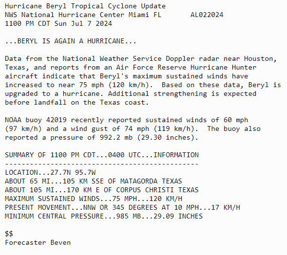
@53rdWRS aircraft data indicate #Beryl has strengthened and is again a hurricane with maximum sustained winds of 75 mph.
0 likes
-
cycloneye

- Admin

- Posts: 149686
- Age: 69
- Joined: Thu Oct 10, 2002 10:54 am
- Location: San Juan, Puerto Rico
Re: ATL: BERYL - Models
In my estimation, HAFS depictions of the dry air muddling the core in GOM were correct and was the best delaying the RI. ICON also did well.
2 likes
Visit the Caribbean-Central America Weather Thread where you can find at first post web cams,radars
and observations from Caribbean basin members Click Here
and observations from Caribbean basin members Click Here
Re: ATL: BERYL - Models
LarryWx wrote:Just for the record, both the 12Z June 30th ICON and JMA had a landfall at Galveston! And many later runs of both have been similar. Are those two going to score a huge win?
Answer: absolutely yes, a big win for ICON and JMA for the W GOM track/TX landfall portion!
2 likes
Personal Forecast Disclaimer:
The posts in this forum are NOT official forecasts and should not be used as such. They are just the opinion of the poster and may or may not be backed by sound meteorological data. They are NOT endorsed by any professional institution or storm2k.org. For official information, please refer to the NHC and NWS products.
The posts in this forum are NOT official forecasts and should not be used as such. They are just the opinion of the poster and may or may not be backed by sound meteorological data. They are NOT endorsed by any professional institution or storm2k.org. For official information, please refer to the NHC and NWS products.
Re: ATL: BERYL - Models
LarryWx wrote:ROCK wrote:12Z JMA hooks it right into Freeport. Just for fun...
Not because it is a good model (it isn’t at all), but for the record just in case the highly unlikely landfall at the upper TX coast were to occur:
these 12Z JMA runs landfall at the upper TX coast: 6/30, 7/2, 7/3, 7/4…so 4 of the last 5 12Z JMA runs
Actual landfall wasn’t up at upper TX coast but still the 6/30 and 7/2-4 JMA runs into Galveston were closer to actual landfall than GFS/Euro/UKMET. Only the ICON was overall about as close. So, kudos to the JMA for the W GOM/TX landfall!
0 likes
Personal Forecast Disclaimer:
The posts in this forum are NOT official forecasts and should not be used as such. They are just the opinion of the poster and may or may not be backed by sound meteorological data. They are NOT endorsed by any professional institution or storm2k.org. For official information, please refer to the NHC and NWS products.
The posts in this forum are NOT official forecasts and should not be used as such. They are just the opinion of the poster and may or may not be backed by sound meteorological data. They are NOT endorsed by any professional institution or storm2k.org. For official information, please refer to the NHC and NWS products.
Re: ATL: BERYL - Models
As noted above, ICON was best of the more respected globals with the W GOM landfall in C TX. This goes back to the 12Z 6/30 run into Galveston! It then had runs up into LA or near the TX/LA border as late as the 6Z on 7/3, which weren’t good. However, starting on 12Z 7/3 (when ICON hit C TX while GFS, Euro, CMC, and UKMET were into NE MX) onward ICON was always between Galveston and Corpus. So, major kudos! CMC wasn’t consistently TX til 0Z of 7/6. UKMET wasn’t til 12Z of 7/5. Euro/GFS wasn’t til 0Z of 7/5.
(ICON also did well with Ian for FL and SC landfalls (2nd best to UKMET)).
JMA gets a well deserved honorable mention as it was similar to the ICON with its 12Z 6/30 run and had several more runs (12Z runs on 6/2, 3, 4) into Galveston followed by 6/5-6 at CC. Actual landfall wasn’t up at upper TX coast but still the 6/30 and 7/2-4 JMA runs into Galveston were much closer to actual landfall than GFS/Euro/UKMET then. Only the ICON was overall about as close.
So, my ratings of globals for W GOM portion of track:
Best: ICON and JMA
Next best but not close: GFS/Euro
Further back: UKMET
Worst: CMC
3 likes
Personal Forecast Disclaimer:
The posts in this forum are NOT official forecasts and should not be used as such. They are just the opinion of the poster and may or may not be backed by sound meteorological data. They are NOT endorsed by any professional institution or storm2k.org. For official information, please refer to the NHC and NWS products.
The posts in this forum are NOT official forecasts and should not be used as such. They are just the opinion of the poster and may or may not be backed by sound meteorological data. They are NOT endorsed by any professional institution or storm2k.org. For official information, please refer to the NHC and NWS products.
-
got ants?

- Tropical Storm
- Posts: 117
- Age: 67
- Joined: Sat Sep 03, 2011 3:44 am
- Location: Hollywood/Ft Laud
Re: ATL: BERYL - Models
LarryWx wrote:LarryWx wrote:ROCK wrote:12Z JMA hooks it right into Freeport. Just for fun...
Not because it is a good model (it isn’t at all), but for the record just in case the highly unlikely landfall at the upper TX coast were to occur:
these 12Z JMA runs landfall at the upper TX coast: 6/30, 7/2, 7/3, 7/4…so 4 of the last 5 12Z JMA runs
Actual landfall wasn’t up at upper TX coast but still the 6/30 and 7/2-4 JMA runs into Galveston were closer to actual landfall than GFS/Euro/UKMET. Only the ICON was overall about as close. So, kudos to the JMA for the W GOM/TX landfall!
This was crazy! Sunday before last, whike tshe was just sout, southeadt of Barbados, I wish-cadted it hitting Carriacou, and was told too early, but I had a feeling. Then on approach to Jamaica, while calls for a turn south, and shear, I again, couldn"t see that action, and wish-cadted it full on landfall on Kingston (thank God it didn't at cat 5). But as far back as that, somecwere already calling for a Texas hit, with NHC saying nope. Cray Cray, was thus storm
0 likes
This post is NOT AN OFFICIAL FORECAST and should not be used as such. It is just the opinion of the poster and may or may not be backed by sound meteorological data. It is NOT endorsed by any professional institution including storm2k.org. For Official Information please refer to the NHC and NWS products.
-
tolakram
- Admin
- Posts: 20186
- Age: 62
- Joined: Sun Aug 27, 2006 8:23 pm
- Location: Florence, KY (name is Mark)
Re: ATL: BERYL - Models
So the question that has to be asked is did these models win due to skill, or did they win due to a consistent right bias? It seems to me a right bias usually wins in the gulf, which is why the Euro, with a consistent left bias, usually loses to the GFS, but only in the gulf.
2 likes
M a r k
- - - - -
Join us in chat: Storm2K Chatroom Invite. Android and IOS apps also available.
The posts in this forum are NOT official forecasts and should not be used as such. Posts are NOT endorsed by any professional institution or STORM2K.org. For official information and forecasts, please refer to NHC and NWS products.
Re: ATL: BERYL - Models
tolakram wrote:So the question that has to be asked is did these models win due to skill, or did they win due to a consistent right bias? It seems to me a right bias usually wins in the gulf, which is why the Euro, with a consistent left bias, usually loses to the GFS, but only in the gulf.
Great Q!
1. JMA:
I’m pretty sure JMA doesn’t have a consistent right bias. If anything, I’d lean toward left bias because I recall many times when it threatened the SE coast for TCs that ended up staying well offshore.
The JMA having done well in the Gulf is by no means a reason by itself to suddenly promote it to respectable as it has more often than not proven to be highly inaccurate. A step above NAVGEM would likely still be as far as I’d now go. The most likely way I’d possibly consider promoting it to respectable in the near future is if I discover it has recently had a major upgrade and no longer is the semi-joke it has been overall. Anyone know?
But even that possible path to promotion to respectability would require consistently decent results vs major models with near future storms.
2. ICON:
A totally different story from JMA as regards already being pretty respectable. For example, it was easily 2nd best to UKMET for the Ian FL/SC landfalls as documented here. Also, it did the best with the historic 1/3/2018 SE coastal winter storm as it on many early runs had the surface low off FL move NNE instead of NE like the other major models thus keeping left side of main precip shield onshore. So, in general unlike JMA, I consider ICON to be a serious model.
Does ICON have a consistent right bias? Not that I’m aware of but I’m not 100% sure. It sure didn’t with the 1/3/18 winter storm. But IF it does, that likely would have helped it with the Ian FL landfall further S.
1 likes
Personal Forecast Disclaimer:
The posts in this forum are NOT official forecasts and should not be used as such. They are just the opinion of the poster and may or may not be backed by sound meteorological data. They are NOT endorsed by any professional institution or storm2k.org. For official information, please refer to the NHC and NWS products.
The posts in this forum are NOT official forecasts and should not be used as such. They are just the opinion of the poster and may or may not be backed by sound meteorological data. They are NOT endorsed by any professional institution or storm2k.org. For official information, please refer to the NHC and NWS products.
Who is online
Users browsing this forum: No registered users and 110 guests