Believe it or not, the 0Z GFS is the 12th in a row that is coming back W into GA on THU AM! Also, after yesterday’s 6Z GEFS was the first run in days to have more members finally getting away from that kind of thing, the last 3 runs have come back S again.
The GFS suite actually has had a little bit of company since 12Z today: the 12Z JMA and now 0Z JMA are also stalling and then coming W into lower SC.
No JMA had done that in the prior days.
ATL: DEBBY - Models
Moderator: S2k Moderators
Re: ATL: DEBBY - Models
0 likes
Personal Forecast Disclaimer:
The posts in this forum are NOT official forecasts and should not be used as such. They are just the opinion of the poster and may or may not be backed by sound meteorological data. They are NOT endorsed by any professional institution or storm2k.org. For official information, please refer to the NHC and NWS products.
The posts in this forum are NOT official forecasts and should not be used as such. They are just the opinion of the poster and may or may not be backed by sound meteorological data. They are NOT endorsed by any professional institution or storm2k.org. For official information, please refer to the NHC and NWS products.
Re: ATL: DEBBY - Models
0Z Euro: again further SW with a LF barely N of CHS. This is the first run since the 12Z 8/3 run that didn’t hit Georgetown or further north.
The 0Z UKMET seems to be running very late.
The 0Z UKMET seems to be running very late.
1 likes
Personal Forecast Disclaimer:
The posts in this forum are NOT official forecasts and should not be used as such. They are just the opinion of the poster and may or may not be backed by sound meteorological data. They are NOT endorsed by any professional institution or storm2k.org. For official information, please refer to the NHC and NWS products.
The posts in this forum are NOT official forecasts and should not be used as such. They are just the opinion of the poster and may or may not be backed by sound meteorological data. They are NOT endorsed by any professional institution or storm2k.org. For official information, please refer to the NHC and NWS products.
-
Kingarabian

- S2K Supporter

- Posts: 16377
- Joined: Sat Aug 08, 2009 3:06 am
- Location: Honolulu, Hawaii
Re: ATL: DEBBY - Models
0Z 8/6 UKMET is finally out: LF Georgetown, then goes to Charlotte but then turns NE and strengthens back down to 990 mb and ends in N Maine.
0 likes
Personal Forecast Disclaimer:
The posts in this forum are NOT official forecasts and should not be used as such. They are just the opinion of the poster and may or may not be backed by sound meteorological data. They are NOT endorsed by any professional institution or storm2k.org. For official information, please refer to the NHC and NWS products.
The posts in this forum are NOT official forecasts and should not be used as such. They are just the opinion of the poster and may or may not be backed by sound meteorological data. They are NOT endorsed by any professional institution or storm2k.org. For official information, please refer to the NHC and NWS products.

Re: ATL: DEBBY - Models
Debby is looking extremely unhealthy atm with the LLC hanging back inland and looking rather parched. Seems like the models have been having a difficult time handling what is appearing to be an accelerated weakening process.
2 likes
Andy D
(For official information, please refer to the NHC and NWS products.)
(For official information, please refer to the NHC and NWS products.)
Re: ATL: DEBBY - Models
There have been 14 GFS runs in a row through the 12Z to turn W back into the coast. But the 12Z is slightly further N and the 6Z and even moreso the 12Z GEFS mean is further N than the operational. Also, fwiw being that it’s an inferior model, the 12Z JMA 72 adjusted back N with it in VA vs yesterday’s 12Z JMA 96 in E C GA.
So, as of now the GFS will likely end up wrong, which history all along strongly suggested.
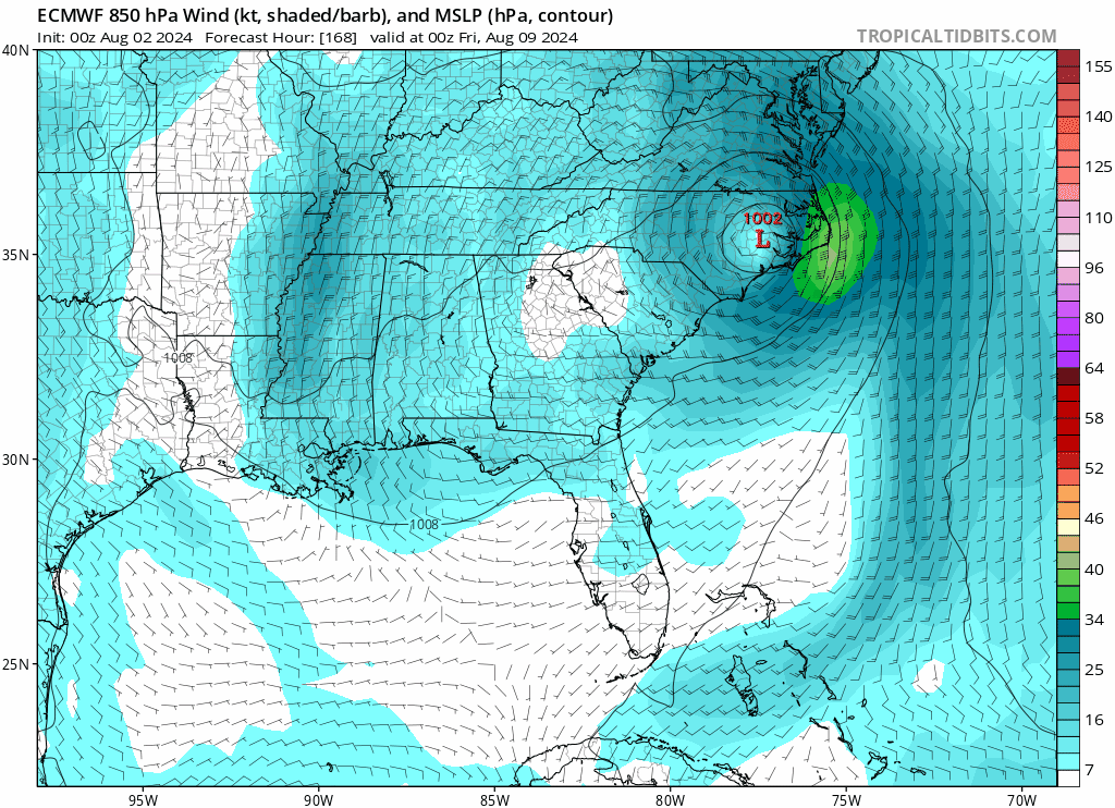
12Z UKMET: landfall Georgetown ~8AM Thu 8/8 and then heads N into VA (~50 miles E of 0Z) followed by NE turn to NE US though not as strong there as 0Z had
12Z Euro: landfall just S of Georgetown ~3AM Thu followed by NNW move into WC NC and then NE move into interior NE US, a little W of UKMET
So, as of now the GFS will likely end up wrong, which history all along strongly suggested.
12Z UKMET: landfall Georgetown ~8AM Thu 8/8 and then heads N into VA (~50 miles E of 0Z) followed by NE turn to NE US though not as strong there as 0Z had
12Z Euro: landfall just S of Georgetown ~3AM Thu followed by NNW move into WC NC and then NE move into interior NE US, a little W of UKMET
0 likes
Personal Forecast Disclaimer:
The posts in this forum are NOT official forecasts and should not be used as such. They are just the opinion of the poster and may or may not be backed by sound meteorological data. They are NOT endorsed by any professional institution or storm2k.org. For official information, please refer to the NHC and NWS products.
The posts in this forum are NOT official forecasts and should not be used as such. They are just the opinion of the poster and may or may not be backed by sound meteorological data. They are NOT endorsed by any professional institution or storm2k.org. For official information, please refer to the NHC and NWS products.
Re: ATL: DEBBY - Models
12Z UKMET: Whereas the 0Z went in just NE of CHS, the 12Z is a little further NE ~midway between CHS and Georgetown. Then goes NNW to near Charlotte then turns NNE to inland in the NE US:
TROPICAL STORM DEBBY ANALYSED POSITION : 32.0N 79.4W
ATCF IDENTIFIER : AL042024
LEAD CENTRAL MAXIMUM WIND
VERIFYING TIME TIME POSITION PRESSURE (MB) SPEED (KNOTS)
-------------- ---- -------- ------------- -------------
1200UTC 07.08.2024 0 32.0N 79.4W 996 36
0000UTC 08.08.2024 12 32.6N 79.3W 995 32
1200UTC 08.08.2024 24 33.6N 79.5W 997 34
0000UTC 09.08.2024 36 34.7N 80.6W 999 32
1200UTC 09.08.2024 48 37.8N 79.9W 999 31
0000UTC 10.08.2024 60 42.2N 76.6W 996 34
1200UTC 10.08.2024 72 47.1N 70.2W 990 34
0000UTC 11.08.2024 84 49.7N 64.9W 989 37
1200UTC 11.08.2024 96 50.0N 57.0W 992 35
0000UTC 12.08.2024 108 CEASED TRACKING
0 likes
Personal Forecast Disclaimer:
The posts in this forum are NOT official forecasts and should not be used as such. They are just the opinion of the poster and may or may not be backed by sound meteorological data. They are NOT endorsed by any professional institution or storm2k.org. For official information, please refer to the NHC and NWS products.
The posts in this forum are NOT official forecasts and should not be used as such. They are just the opinion of the poster and may or may not be backed by sound meteorological data. They are NOT endorsed by any professional institution or storm2k.org. For official information, please refer to the NHC and NWS products.
Who is online
Users browsing this forum: No registered users and 85 guests