ATL: MILTON - Models
Moderator: S2k Moderators

Re: ATL: INVEST 92L - Models
The models are all over the place, we are just going to have to wait for the NHC i think. GFS went south 1 run yesterday, then went north, and now more north. The others pushed south euro etc.. have consistently said ft Myers south tho
0 likes
-
DESTRUCTION5

- Category 5

- Posts: 4430
- Age: 44
- Joined: Wed Sep 03, 2003 11:25 am
- Location: Stuart, FL
Re: ATL: INVEST 92L - Models
Stormlover70 wrote:Why look at the worse case models? They are outliers. We don't need another hit in this area. Sorry just can't take anything else......
If any of these intensity models come to fruition it will be bad no matter where he comes in. Naples to Tampa. At this point it's coming and preps on the west coast anywhere near water need to commence.
2 likes
GATOR NATION IS E V E R Y W H E R E !
-
REDHurricane

- Category 1

- Posts: 438
- Age: 28
- Joined: Sun Jul 03, 2022 2:36 pm
- Location: Northeast Pacific Ocean
Re: ATL: INVEST 92L - Models
ronjon wrote:REDHurricane wrote:ronjon wrote:Amazing how quickly forecasts on intensity can change when just a few days ago wxman57 was doubting this system would be more than a frontal low. GFS and now the hurricane models (all that performed well on intensity with Helene) now pointing toward another major hurricane striking the west coast of Florida. This just makes me sick to my stomach here on the western side of the state.
Just goes to show that hope is not an effective forecasting tool... as much as we all wished Helene was only going to make landfall at 75kts and we all hope 92L won't develop into anything worse than a rainmaker, I think downplaying any potential Gulf system before it even gets started is a dangerous game to be playing when the entire Gulf is 1-2ºC above average in a strengthening La Niña pattern. I respect the knowledge of all the pro mets on here (who have undoubtedly forgotten more about weather than I've ever learned), but that doesn't mean that any single expert's predictions should be taken as gospel since we are all prone to our own biases and have our own blind spots.
I think to be fair here to wxman57 and the other PROS, all the modeling on the synoptic pattern a few days ago was pointing to high shear and dry air severely impacting the system in the GOM and thus keeping it weak. A rain maker only was the consistent theme.
True, but I still think it's unwise in general to publicly downplay/dismiss the threat of any disturbance projected to emerge and spend 5 entire days over the GoM jacuzzi, especially before anything is even there, at the beginning of October in a quickly developing La Niña background state. Plus, ICON (i.e. the most reliable model for Gulf systems as of late) has been showing the possibility of a hurricane as early as 00z October 1st, so it's not like this scenario came completely out of the blue... I'm not trying to say that I'm any better at forecasting because I know I'm not, but preemptively predicting with authority that nothing more than a run-of-the-mill frontal low will come out of an expected/not yet present Gulf setup in these conditions when it's actually more of a wishcast just doesn't seem like the greatest idea in my humble opinion.
7 likes
-
gatorcane

- S2K Supporter

- Posts: 23708
- Age: 48
- Joined: Sun Mar 13, 2005 3:54 pm
- Location: Boca Raton, FL
Re: ATL: INVEST 92L - Models
1 likes
Re: ATL: INVEST 92L - Models
gatorcane wrote:
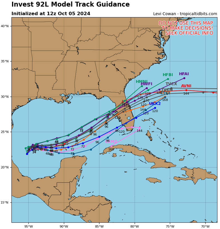
Wow is right and here is the 12Z guidance:
https://i.postimg.cc/C13wn7dh/92-L-tracks-12z.png
NHC's favored, TVCN goes north side of Bradenton/along the southern edge of the bay. Worst surge with that track would be (right side) Siesta Key/Sarasota/Venice inbound, outbound into the Atlantic onshore surge (left side) gets New Smyrna, Daytona, Ormond.
0 likes
-
gatorcane
- S2K Supporter
- Posts: 23708
- Age: 48
- Joined: Sun Mar 13, 2005 3:54 pm
- Location: Boca Raton, FL
Re: ATL: INVEST 92L - Models
Here is the 06Z GFS Simulated IR loop, let's hope it backs off on the intensity in future runs. It looks like there might be some shear in the EGOM and around Florida which might weaken it some before landfall at the last minute, but still this looks no bueno:
1 likes
-
Hypercane_Kyle

- Category 5
- Posts: 3465
- Joined: Sat Mar 07, 2015 7:58 pm
- Location: Cape Canaveral, FL
Re: ATL: INVEST 92L - Models
Stormlover70 wrote:Why look at the worse case models? They are outliers. We don't need another hit in this area. Sorry just can't take anything else......
We're not just looking at the worst case models. Virtually all of the reliable models are showing this becoming a hurricane.
5 likes
My posts are my own personal opinion, defer to the National Hurricane Center (NHC) and other NOAA products for decision making during hurricane season.

Re: ATL: INVEST 92L - Models
gatorcane wrote:Here is the 06Z GFS Simulated IR loop, let's hope it backs off on the intensity in future runs. It looks like there might be some shear in the EGOM and around Florida which might weaken it some before landfall at the last minute, but still this looks no bueno:
https://i.postimg.cc/G2vbYfNM/gfs-ir-watl-fh1-115.gif
Looks like SE Florida will dodge Milton but still too early to tell yet.
0 likes
-
Category5Kaiju

- Category 5
- Posts: 4331
- Joined: Thu Dec 24, 2020 12:45 pm
- Location: Seattle and Phoenix
Re: ATL: INVEST 92L - Models
gatorcane wrote:Here is the 06Z GFS Simulated IR loop, let's hope it backs off on the intensity in future runs. It looks like there might be some shear in the EGOM and around Florida which might weaken it some before landfall at the last minute, but still this looks no bueno:
https://i.postimg.cc/G2vbYfNM/gfs-ir-watl-fh1-115.gif
If there was decent flooding in the bay when Helene happened, I can't help but imagine what it would look like with a storm like that.
2 likes
Unless explicitly stated, all info in my posts is based on my own opinions and observations. Tropical storms and hurricanes can be extremely dangerous. Refer to an accredited weather research agency or meteorologist if you need to make serious decisions regarding an approaching storm.


Re: ATL: INVEST 92L - Models
Hypercane_Kyle wrote:Stormlover70 wrote:Why look at the worse case models? They are outliers. We don't need another hit in this area. Sorry just can't take anything else......
We're not just looking at the worst case models. Virtually all of the reliable models are showing this becoming a hurricane.
Plus, I think someone mentioned a while ago that hurricane models are actually the best intensity models we have, even though they often have the tendency to overintensify things.
1 likes
TC naming lists: retirements and intensity
Most aggressive Advisory #1's in North Atlantic (cr. kevin for starting the list)
Most aggressive Advisory #1's in North Atlantic (cr. kevin for starting the list)
Re: ATL: INVEST 92L - Models
Luis...can you offer your thoughts on 92L?.....from where I'm sittin...I believe any cyclone in the gulf is a dangerous situation....what are your thoughts...concerning intensity?...and also...im a bit out of the loop....is this a TD?....its not showing on the NHC...
Last edited by underthwx on Sat Oct 05, 2024 9:59 am, edited 1 time in total.
0 likes


Re: ATL: INVEST 92L - Models
Teban54 wrote:Hypercane_Kyle wrote:Stormlover70 wrote:Why look at the worse case models? They are outliers. We don't need another hit in this area. Sorry just can't take anything else......
We're not just looking at the worst case models. Virtually all of the reliable models are showing this becoming a hurricane.
Plus, I think someone mentioned a while ago that hurricane models are actually the best intensity models we have, even though they often have the tendency to overintensify things.
Yeah I mean that's why they exist
1 likes
Hurricane Experience: Charley 2004, Frances 2004, Jeanne 2004, Matthew 2016, Irma 2017, Dorian 2019, Ian 2022, Nicole 2022, Helene 2024, Milton 2024

-
chris_fit

- Category 5
- Posts: 3261
- Age: 43
- Joined: Wed Sep 10, 2003 11:58 pm
- Location: Tampa Bay Area, FL
Re: ATL: FOURTEEN - Models
12z ICON looks like a 980mb hurricane into Englewood. North shift from 06z and stronger.
0 likes
Re: ATL: FOURTEEN - Models
I’ll need to see the next couple sets of model runs to be even halfway sure, but since weaker storm seem to be heading more southward while the stronger storms tend to be heading northward, A strong cat three or week cat four would likely land right on Tampa’s doorstep
0 likes
Re: ATL: FOURTEEN - Models
chris_fit wrote:12z ICON looks like a 980mb hurricane into Englewood. North shift from 06z and stronger.
Yeah, weak but the track looks good.
0 likes
Who is online
Users browsing this forum: No registered users and 6 guests