ATL: BERYL - Post-Tropical - Discussion
Moderator: S2k Moderators

Re: ATL: BERYL - Hurricane - Discussion
Coldest CDO since Beryl's initial RI to a MH. Current recon or the next one might catch it at peak intensity.
0 likes

Re: ATL: BERYL - Hurricane - Discussion
5 likes
TC naming lists: retirements and intensity
Most aggressive Advisory #1's in North Atlantic (cr. kevin for starting the list)
Most aggressive Advisory #1's in North Atlantic (cr. kevin for starting the list)


Re: ATL: BERYL - Hurricane - Discussion
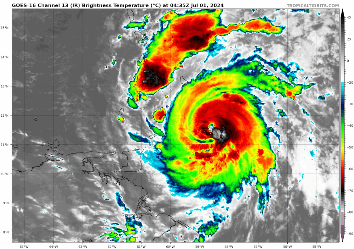
kevin wrote:Beryl now:
https://i.imgur.com/gdzVuzM.png
Beryl 2 hours ago:
https://i.imgur.com/5Wk6wxh.png
Better on the IR. Each of the photos is 2 hours apart.
4 likes
TC naming lists: retirements and intensity
Most aggressive Advisory #1's in North Atlantic (cr. kevin for starting the list)
Most aggressive Advisory #1's in North Atlantic (cr. kevin for starting the list)
Re: ATL: BERYL - Hurricane - Discussion
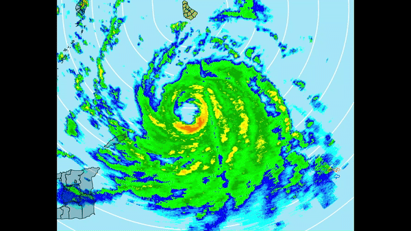
Unsurprisingly, under the hood of extremely cold convection is a thicc eyewall:
10 likes
TC naming lists: retirements and intensity
Most aggressive Advisory #1's in North Atlantic (cr. kevin for starting the list)
Most aggressive Advisory #1's in North Atlantic (cr. kevin for starting the list)
-
Hurricane Mike
- Category 2

- Posts: 675
- Joined: Tue Apr 10, 2018 7:44 am
Re: ATL: BERYL - Hurricane - Discussion
5am video on Beryl
https://www.youtube.com/watch?v=m6fcvWgDoRw
https://www.youtube.com/watch?v=m6fcvWgDoRw
0 likes
Re: ATL: BERYL - Hurricane - Discussion
First pass 957.8 mb with 27 kt winds, 104 kt FL winds and 103 kt SFMR. Supports a pressure of 955 mb, but with winds in the 100 - 105 kt range. So deepening again, but winds still need to catch up. Could also be that the highest wind quads haven't been sampled yet. I expect the pressure/wind ratio to be more typical from now on compared to before when the pressure in the 960s was somewhat high for a cat 4.
2 likes
Re: ATL: BERYL - Hurricane - Discussion
Also no indication of double-wind maxima during this pass so it seems the EWRC has been completed.
1 likes

Re: ATL: BERYL - Hurricane - Discussion
Teban54 wrote:Unsurprisingly, under the hood of extremely cold convection is a thicc eyewall:
https://i.postimg.cc/HxSJsx8G/ezgif-7-5d48e3b857.gif
This and the latest recon pass show the EWRC is just about done. That eye should start clearing out over the next few hours and it’ll be off to the races.
1 likes
Irene '11 Sandy '12 Hermine '16 5/15/2018 Derecho Fay '20 Isaias '20 Elsa '21 Henri '21 Ida '21
I am only a meteorology enthusiast who knows a decent amount about tropical cyclones. Look to the professional mets, the NHC, or your local weather office for the best information.
I am only a meteorology enthusiast who knows a decent amount about tropical cyclones. Look to the professional mets, the NHC, or your local weather office for the best information.

Re: ATL: BERYL - Hurricane - Discussion
Those RH measurements from the eye drops yesterday indicating initiation of an EWRC were all over the place.
First one said there was, second said there wasn't, third said there was.
The first VDM from Gonzo also didn't indicate any EWRC rather a pin hole.
Sorry for the confusion.
Point is there is a high chance of an EWRC shortly after a strong RI event.
First one said there was, second said there wasn't, third said there was.
The first VDM from Gonzo also didn't indicate any EWRC rather a pin hole.
Sorry for the confusion.
Point is there is a high chance of an EWRC shortly after a strong RI event.
2 likes
-
Hypercane_Kyle

- Category 5

- Posts: 3465
- Joined: Sat Mar 07, 2015 7:58 pm
- Location: Cape Canaveral, FL
Re: ATL: BERYL - Hurricane - Discussion
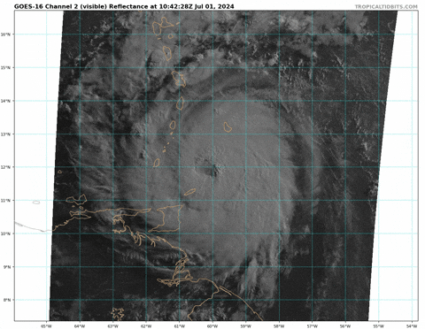
Taking on a nasty look now the EWRC is wrapping up, a much larger eye is about to come out with cold cloud tops in the eyewall.

3 likes
My posts are my own personal opinion, defer to the National Hurricane Center (NHC) and other NOAA products for decision making during hurricane season.
Re: ATL: BERYL - Hurricane - Discussion
Beryl will start to get cut off from the Amazon high-TPW feed shortly after passing the islands.
This is due to the feed interacting with the mountains of South America and is the well know E Carib Graveyard effect.
Will need to watch when it is in mid Carib and will try to connect with EPAC high TPW air thru Panama.
This is due to the feed interacting with the mountains of South America and is the well know E Carib Graveyard effect.
Will need to watch when it is in mid Carib and will try to connect with EPAC high TPW air thru Panama.
3 likes
-
ColdMiser123

- Professional-Met

- Posts: 905
- Age: 29
- Joined: Mon Sep 26, 2016 3:26 pm
- Location: Northeast US
Re: ATL: BERYL - Hurricane - Discussion
This kind of larger core structure post-EWRC makes it more resilient to wind shear than its previous core. Small cores tend to be more vulnerable to even moderate shear.
The fact that this has a well organized, larger inner core, means it has given itself the best chance of surviving its trek across the Caribbean.
The fact that this has a well organized, larger inner core, means it has given itself the best chance of surviving its trek across the Caribbean.
6 likes
B.S., M.S., Meteorology & Atmospheric Science
-
jlauderdal
- S2K Supporter

- Posts: 7240
- Joined: Wed May 19, 2004 5:46 am
- Location: NE Fort Lauderdale
- Contact:
Re: ATL: BERYL - Hurricane - Discussion
GCANE wrote:Beryl will start to get cut off from the Amazon high-TPW feed shortly after passing the islands.
This is due to the feed interacting with the mountains of South America and is the well know E Carib Graveyard effect.
Will need to watch when it is in mid Carib and will try to connect with EPAC high TPW air thru Panama.
This system wants to survive the graveyard, and it appears the EWRC will be completed in plenty of time. Yucatan and points south, get ready.
2 likes

Re: ATL: BERYL - Hurricane - Discussion
ColdMiser123 wrote:This kind of larger core structure post-EWRC makes it more resilient to wind shear than its previous core. Small cores tend to be more vulnerable to even moderate shear.
The fact that this has a well organized, larger inner core, means it has given itself the best chance of surviving its trek across the Caribbean.
Lucky for Barbados that the larger eye didn't clear out earlier since wind fields will be expanding.
Shallow ULL forming over the Bahamas in the WV loop will that be the replacement for the TUTT to the north?
2 likes
-
REDHurricane

- Category 1

- Posts: 438
- Age: 28
- Joined: Sun Jul 03, 2022 2:36 pm
- Location: Northeast Pacific Ocean
-
wxman57

- Moderator-Pro Met

- Posts: 23170
- Age: 68
- Joined: Sat Jun 21, 2003 8:06 pm
- Location: Houston, TX (southwest)
Re: ATL: BERYL - Hurricane - Discussion
Consensus models, as I expected, have shifted back south. Now they're south of NHC's last track. Ensembles have been quite steady in taking Beryl well south of Jamaica and inland into central to northern Belize. Consensus models now agree. Look for a south NHC track shift in their next advisory. The A-B-C islands could get some TS winds as Beryl passes.
2 likes
-
jlauderdal
- S2K Supporter
- Posts: 7240
- Joined: Wed May 19, 2004 5:46 am
- Location: NE Fort Lauderdale
- Contact:
Re: ATL: BERYL - Hurricane - Discussion
Solid messaging by the St Lucia Govt, preparation in the Caribbean is always on target and on message. Grenada looks like a direct hit but it will be a fast recovery.
https://www.youtube.com/live/2dQMsMfD8lA
https://www.youtube.com/live/2dQMsMfD8lA
1 likes
-
Stratton23
- Category 5
- Posts: 3509
- Joined: Fri Jul 21, 2023 10:59 pm
- Location: Katy, Tx
Re: ATL: BERYL - Hurricane - Discussion
Yeah that south trend might start to be reversing, GFS and ICON now have this going straight over jamaica, GEFS ensembles just came out, and now half the members either hit jamaica or pass it by to the north, something to watch if anyone has friends ir family in that are
1 likes
Re: ATL: BERYL - Hurricane - Discussion
Much stronger second pass in terms of wind speed. 130 kt FL and 123 kt SFMR, supports 120 kt. Center 957 mb with 35 kt so ~954 mb.
3 likes
Who is online
Users browsing this forum: No registered users and 4 guests