
ATL: BERYL - Models
Moderator: S2k Moderators
Re: ATL: BERYL - Models
12Z Euro ensemble with more members into the Mid/Upper TX coast. Ensemble mean shifted north.
0 likes
-
Texashawk

- Category 2

- Posts: 579
- Joined: Tue Aug 14, 2007 1:50 am
- Location: Missouri City, TX (Houston)
Re: ATL: BERYL - Models
IcyTundra wrote:12Z Euro ensemble with more members into the Mid/Upper TX coast. Ensemble mean shifted north.
https://i.ibb.co/dbZx5yK/AL02-2024070512-ECENS-0-120h.png
Well, that escalated quickly for those of us in Houston who have been told ‘we should be OK’

3 likes

Re: ATL: BERYL - Models
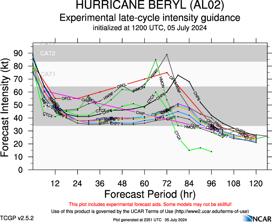
Late cycle (12z) Intensity Guidance shows the Hurricane Models with the biggest spikes in intensity. That's not a surprise, but sometimes they get the depictions right.
https://hurricanes.ral.ucar.edu/realtim ... mental.png
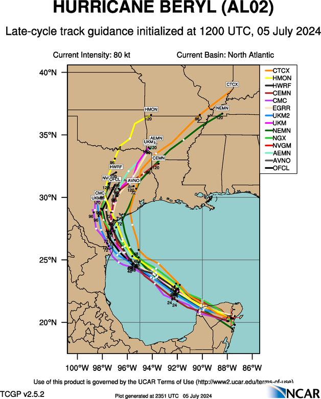
Late cycle (12z) Track Guidance pretty much eliminates a Mexico landfall. But expect to see maybe a nudge north in most of the members for the early cycle 18z guidance.
https://hurricanes.ral.ucar.edu/realtim ... k_late.png
https://hurricanes.ral.ucar.edu/realtim ... mental.png
Late cycle (12z) Track Guidance pretty much eliminates a Mexico landfall. But expect to see maybe a nudge north in most of the members for the early cycle 18z guidance.
https://hurricanes.ral.ucar.edu/realtim ... k_late.png
0 likes
Re: ATL: BERYL - Models
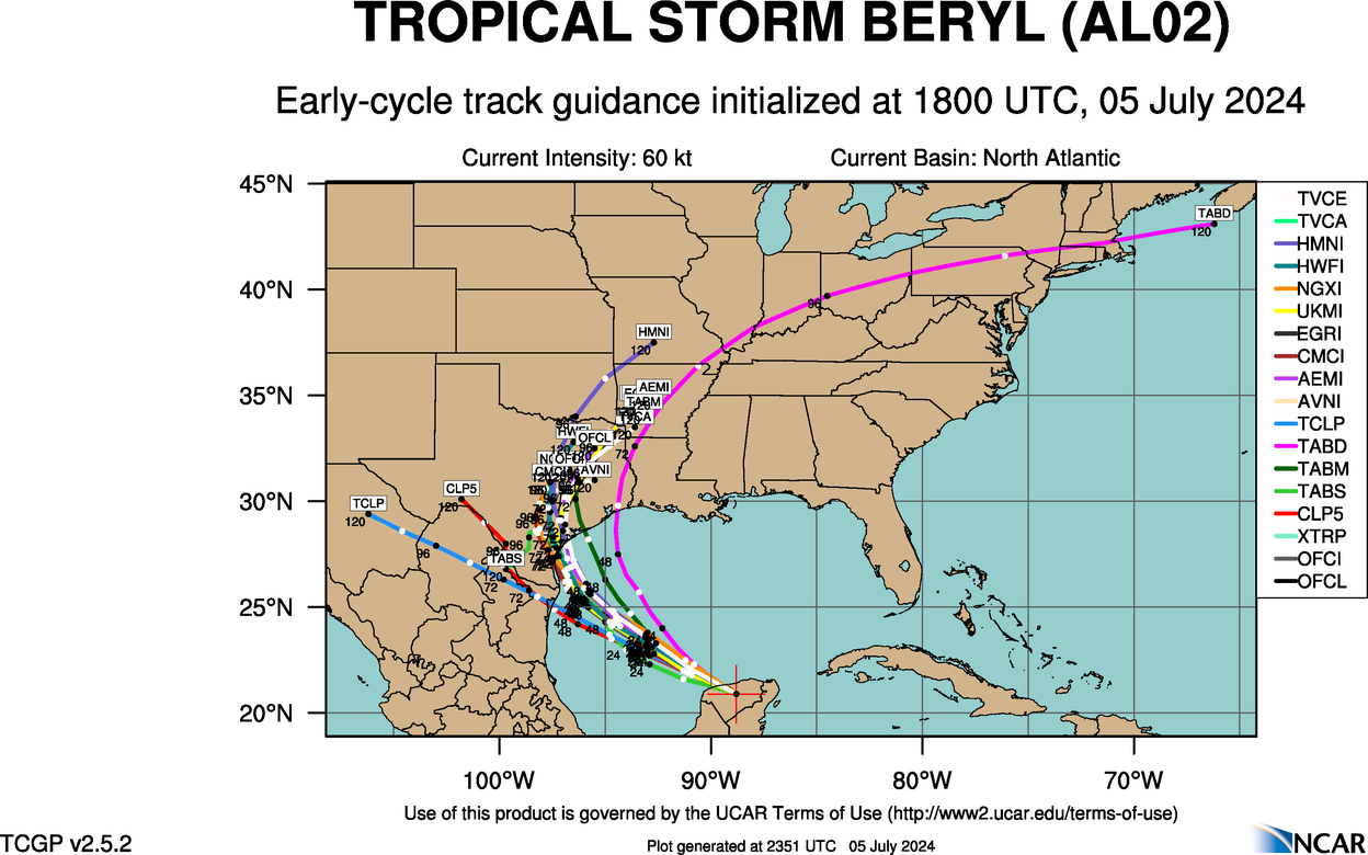
18z Early Cycle is out. I still think this is too far south.
https://hurricanes.ral.ucar.edu/realtim ... _early.png
https://hurricanes.ral.ucar.edu/realtim ... _early.png
1 likes
-
jaguars_22
- Category 2
- Posts: 629
- Joined: Tue Jun 20, 2017 2:26 pm
- Location: Victoria TX
Re: ATL: BERYL - Models
Are we thinking higher than port o Connor for landfall??? What percentage would you give me in Victoria for getting strong winds?
0 likes
-
sphelps8681
- Category 2
- Posts: 785
- Joined: Thu Aug 16, 2007 5:37 pm
- Location: Somewhere over the rainbow
Re: ATL: BERYL - Models
jaguars_22 wrote:Are we thinking higher than port o Connor for landfall??? What percentage would you give me in Victoria for getting strong winds?
In my opinion just prep like there will be. Better safe than sorry. JMO.
2 likes
-
tolakram
- Admin

- Posts: 20186
- Age: 62
- Joined: Sun Aug 27, 2006 8:23 pm
- Location: Florence, KY (name is Mark)
Re: ATL: BERYL - Models
Crazy. Just posting another image to make sure it's saved for looking back someday. The Euro has a really bad habit of being undependable for gulf storms.

1 likes
M a r k
- - - - -
Join us in chat: Storm2K Chatroom Invite. Android and IOS apps also available.
The posts in this forum are NOT official forecasts and should not be used as such. Posts are NOT endorsed by any professional institution or STORM2K.org. For official information and forecasts, please refer to NHC and NWS products.

-
HurricaneBelle

- S2K Supporter

- Posts: 1209
- Joined: Sun Aug 27, 2006 6:12 pm
- Location: Clearwater, FL
Re: ATL: BERYL - Models
ROCK wrote:18Z ICON is running....oh boy...
Knowing the ICON lately, it'll probably make it a Florida storm
1 likes

Re: ATL: BERYL - Models
ROCK wrote:18Z ICON is running....oh boy...
Does the 18z Icon initialize too far west?
0 likes
-
Stratton23
- Category 5

- Posts: 3573
- Joined: Fri Jul 21, 2023 10:59 pm
- Location: Katy, Tx
-
HoustonFrog
- Tropical Depression

- Posts: 98
- Joined: Thu Jun 04, 2020 1:49 pm
Re: ATL: BERYL - Models
Basically zero change from 12z to 18z for ICON. Strong cat 2/weak cat 3 into Galveston
1 likes
Re: ATL: BERYL - Models
IcyTundra wrote:18Z ICON Galveston Landfall
https://i.ibb.co/2gsw5r9/icon-mslp-pcpn-watl-fh3-63.gif
Welp”
0 likes
Harvey,Hanna,Beta,Texas Winter storm2021,Nicholas,Beryl
-
Frank P
- S2K Supporter
- Posts: 2779
- Joined: Fri Aug 29, 2003 10:52 am
- Location: Biloxi Beach, Ms
- Contact:
Re: ATL: BERYL - Models
ICON has been basically forecasting this for some time. no surprise to me and 967 mb is quite the storm, on the cusp of a CAT 3, and with Beryl's history of having a higher pressure and unusually higher wind intensities I would image a Cat 3 would be in the cards if this comes to fruition
Last edited by Frank P on Fri Jul 05, 2024 4:35 pm, edited 1 time in total.
1 likes
-
Stormcenter
- S2K Supporter
- Posts: 6689
- Joined: Wed Sep 03, 2003 11:27 am
- Location: Houston, TX
Re: ATL: BERYL - Models
Maybe a lot too far south.
Steve wrote:18z Early Cycle is out. I still think this is too far south.
https://hurricanes.ral.ucar.edu/realtim ... _early.png
1 likes
Re: ATL: BERYL - Models
On WV loop - notice the clouds/weather is moving to the NE. This may influence Beryl in time.
Mexico landfall may end up Fl panhandle landfall
Mexico landfall may end up Fl panhandle landfall
0 likes

Re: ATL: BERYL - Models
crimi481 wrote:On WV loop - notice the clouds/weather is moving to the NE. This may influence Beryl in time.
Mexico landfall may end up Fl panhandle landfall
Not hardly..
2 likes
Re: ATL: BERYL - Models
Frank P wrote:ICON has been basically forecasting this for some time. no surprise to me and 967 mb is quite the storm, on the cusp of a CAT 3, and with Beryl's history of having a higher pressure and lower wind intensities I would image a Cat 3 would be in the cards if this comes to fruition
agree...this model is so persistent...I don't think I have ever seen a model do this without some wild windshield wiper swings. I didn't some research on it between work and it is ran off some EURO parameters which was interesting.
1 likes

Re: ATL: BERYL - Models
davidiowx wrote:crimi481 wrote:On WV loop - notice the clouds/weather is moving to the NE. This may influence Beryl in time.
Mexico landfall may end up Fl panhandle landfall
Not hardly..
Agreed. This isn't October. Won't get a deep longwave trough into western GOM this time of year to steer this system into FL panhandle. The forecast trough will only erode the western periphery of the mid-level ridge over the SE. Allowing the storm to round the high in a gradual way.
2 likes
Who is online
Users browsing this forum: No registered users and 62 guests