ATL: BERYL - Models

Moderator: S2k Moderators

Message
Author
User avatar
Nimbus
Category 5
Category 5
Posts: 5274
Joined: Mon Jul 19, 2004 10:54 am

Re: ATL: TWO - Models

#121 Postby Nimbus » Fri Jun 28, 2024 6:30 pm

18Z HWRF has this a hurricane tomorrow night, going to be an interesting run.
Looks like it is shooting the gap north of Jamaica.

Image
Last edited by Nimbus on Fri Jun 28, 2024 7:53 pm, edited 2 times in total.
2 likes   

BobHarlem
Category 5
Category 5
Posts: 2034
Joined: Thu Oct 20, 2005 6:11 pm

Re: ATL: TWO - Models

#122 Postby BobHarlem » Fri Jun 28, 2024 6:33 pm

HAFSB closest approach to Barbados, solid cat 3 here.
Image
5 likes   

User avatar
ElectricStorm
Category 5
Category 5
Posts: 5017
Age: 24
Joined: Tue Aug 13, 2019 11:23 pm
Location: Skiatook, OK / Norman, OK

Re: ATL: TWO - Models

#123 Postby ElectricStorm » Fri Jun 28, 2024 7:14 pm

HWRF and HMON get this to Cat 4, HAFS A and B both have a Cat 3. I initially figured this would struggle to get higher than lower end Cat 1 given the time of year, and I'm still a little skeptical it becomes a major but it seems like it's starting to become a possibility.
1 likes   
I am in no way a professional. Take what I say with a grain of salt as I could be totally wrong. Please refer to the NHC, NWS, or SPC for official information.

Boomer Sooner!

User avatar
Hypercane_Kyle
Category 5
Category 5
Posts: 3344
Joined: Sat Mar 07, 2015 7:58 pm
Location: Cape Canaveral, FL

Re: ATL: TWO - Models

#124 Postby Hypercane_Kyle » Fri Jun 28, 2024 7:25 pm

If the HWRF ended up being right with intensity (big, big if) - I have serious doubts that we'd see full-on dissipation like what the GFS is depicting in the western Caribbean. There'd be enough to weaken the system, but at that point land interaction would be the main driver.
0 likes   
My posts are my own personal opinion, defer to the National Hurricane Center (NHC) and other NOAA products for decision making during hurricane season.

User avatar
Ubuntwo
Category 5
Category 5
Posts: 1401
Age: 31
Joined: Thu Oct 05, 2017 10:41 pm

Re: ATL: TWO - Models

#125 Postby Ubuntwo » Fri Jun 28, 2024 8:23 pm

Hypercane_Kyle wrote:If the HWRF ended up being right with intensity (big, big if) - I have serious doubts that we'd see full-on dissipation like what the GFS is depicting in the western Caribbean. There'd be enough to weaken the system, but at that point land interaction would be the main driver.

GFS is only showing dissipation due to interaction with the mountains of Hispaniola. The Tiburon peninsula, though narrow, has peaks in excess of 7,000ft. It's TC poison - especially for a small, compact system. Direct landfall is not needed, either, as low level inflow is easily choked off for a system on the south side of the island. I agree that without land interaction, the anticyclone would be well-established enough to prevent serious decay.
1 likes   
Kendall -> SLO -> PBC

Memorable Storms: Katrina (for its Florida landfall...) Wilma Matthew Irma

BobHarlem
Category 5
Category 5
Posts: 2034
Joined: Thu Oct 20, 2005 6:11 pm

Re: ATL: BERYL - Models

#126 Postby BobHarlem » Fri Jun 28, 2024 10:58 pm

0z gfs clips Barbados on the right side and then goes over St. Vincent. Once in the caribbean it's a little left (south) of 18z.

Image

Later a bit weaker (probably tutt) but manages to slip into the gap between Jamaica and Haiti so it doesn't get as torn up as 18z. (And yeah the other system east of Beryl goes right over the same places more or less) Then gets pretty close to the Cayman Islands.
Image

Manages to miss cuba this run too although other factors are keeping it pretty weak here. The other wave is riding the wake.
Image

Interestingly when both systems get into the gulf, both go poof.
0 likes   

User avatar
weeniepatrol
Category 5
Category 5
Posts: 1252
Joined: Sat Aug 22, 2020 5:30 pm
Location: WA State

Re: ATL: BERYL - Models

#127 Postby weeniepatrol » Fri Jun 28, 2024 11:42 pm

GEFS trends stronger. All members now at least 40 kt 2-3 days out

0 likes   

User avatar
Teban54
Category 5
Category 5
Posts: 3168
Joined: Sat May 19, 2018 1:19 pm

Re: ATL: BERYL - Models

#128 Postby Teban54 » Sat Jun 29, 2024 5:31 am

0 likes   

User avatar
cycloneye
Admin
Admin
Posts: 143867
Age: 68
Joined: Thu Oct 10, 2002 10:54 am
Location: San Juan, Puerto Rico

Re: ATL: BERYL - Models

#129 Postby cycloneye » Sat Jun 29, 2024 5:35 am

GFS now extends to GOM.

Image
2 likes   
Visit the Caribbean-Central America Weather Thread where you can find at first post web cams,radars
and observations from Caribbean basin members Click Here

User avatar
cycloneye
Admin
Admin
Posts: 143867
Age: 68
Joined: Thu Oct 10, 2002 10:54 am
Location: San Juan, Puerto Rico

Re: ATL: BERYL - Models

#130 Postby cycloneye » Sat Jun 29, 2024 5:56 am

Beryl to SE Texas.

Image
1 likes   
Visit the Caribbean-Central America Weather Thread where you can find at first post web cams,radars
and observations from Caribbean basin members Click Here

User avatar
Blown Away
S2K Supporter
S2K Supporter
Posts: 10140
Joined: Wed May 26, 2004 6:17 am

Re: ATL: BERYL - Models

#131 Postby Blown Away » Sat Jun 29, 2024 7:07 am

Image

If HWRF is right, could be one of the strongest hurricanes to track over St. Vincent.
0 likes   
Hurricane Eye Experience: David 79, Irene 99, Frances 04, Jeanne 04, Wilma 05... EYE COMING MY WAY IN 2024…
Hurricane Brush Experience: Andrew 92, Erin 95, Floyd 99, Matthew 16, Irma 17, Ian 22, Nicole 22…

BobHarlem
Category 5
Category 5
Posts: 2034
Joined: Thu Oct 20, 2005 6:11 pm

Re: ATL: BERYL - Models

#132 Postby BobHarlem » Sat Jun 29, 2024 8:37 am

Track consensus shifted left (south) again, looks more and more likely to avoid land areas after the Windwards, at least until the Yucatan Peninsula (Belize/Mexico border). Jamaica though, it's going to be close there. Maybe the Cayman Islands also.

Image
1 likes   

User avatar
REDHurricane
Category 1
Category 1
Posts: 394
Age: 27
Joined: Sun Jul 03, 2022 2:36 pm
Location: Northeast Pacific Ocean

Re: ATL: BERYL - Models

#133 Postby REDHurricane » Sat Jun 29, 2024 11:03 am

Just for fun, here's a quick look at how the most recent run of each hurricane model has initialized Beryl compared to forecast intensity as it approaches the Windward Islands:

ACTUAL IR SATELLITE VIEW (as of 15:25z):
Image


HWRF initialization:
Image

HWRF forecast:
Image


HAFS-A initialization:
Image

HAFS-A forecast:
Image


HAFS-B initialization:
Image

HAFS-B forecast:
Image


To me it appears that HWRF has the best idea of the current storm structure and potential track/intensity, but I'll be interested to see how the next few hurricane model runs turn out regardless.
5 likes   

3090
Category 2
Category 2
Posts: 548
Age: 65
Joined: Fri Aug 19, 2011 4:01 pm

Re: ATL: BERYL - Models

#134 Postby 3090 » Sat Jun 29, 2024 11:08 am

Noticing an ever slight bend/track more towards the upper NE corner of the YP, in the most recent official NHC extended forecast track, beyond 5 days. Previous extended track, was more of a bend towards the middle of the YP, after brushing Cayman island. Is this a trend, beyond 5 days? Time will tell. Not sure if the very southern most Texas gulf coast is clear, in the very extended forecast period. WAY too soon to call.
0 likes   

BobHarlem
Category 5
Category 5
Posts: 2034
Joined: Thu Oct 20, 2005 6:11 pm

Re: ATL: BERYL - Models

#135 Postby BobHarlem » Sat Jun 29, 2024 11:09 am

0 likes   

3090
Category 2
Category 2
Posts: 548
Age: 65
Joined: Fri Aug 19, 2011 4:01 pm

Re: ATL: BERYL - Models

#136 Postby 3090 » Sat Jun 29, 2024 11:09 am

REDHurricane wrote:Just for fun, here's a quick look at how the most recent run of each hurricane model has initialized Beryl compared to forecast intensity as it approaches the Windward Islands:

ACTUAL IR SATELLITE VIEW (as of 15:25z):
https://i.ibb.co/RSszLSV/0e03dd29-ff63-42f2-9dcd-a28c2e1fd0a1.jpg


HWRF initialization:
https://i.ibb.co/KVhfFR7/hwrf-sat-IR-02-L-3.png
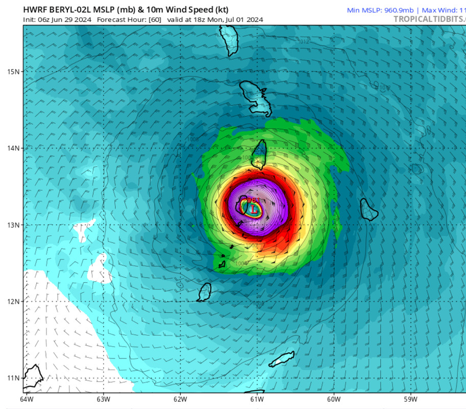
HWRF forecast:
https://i.ibb.co/ygfvK7K/hwrf-mslp-wind-02-L-20.png


HAFS-A initialization:
https://i.ibb.co/Ln5gFc9/hafsa-sat-IR-02-L-5.png

HAFS-A forecast:
https://i.ibb.co/8bh2H8B/hafsa-mslp-wind-02-L-20.png


HAFS-B initialization:
https://i.ibb.co/GnyJjVj/hafsb-sat-IR-02-L-5.png

HAFS-B forecast:
https://i.ibb.co/9w73GKV/hafsb-mslp-wind-02-L-20.png


To me it appears that HWRF has the best idea of the current storm structure and potential track/intensity, but I'll be interested to see how the next few hurricane model runs turn out regardless.
This is interesting and excellent! Thanks.
1 likes   

User avatar
Cpv17
Category 5
Category 5
Posts: 4915
Joined: Wed Dec 07, 2016 2:24 pm
Location: Wharton/El Campo, TX

Re: ATL: BERYL - Models

#137 Postby Cpv17 » Sat Jun 29, 2024 11:12 am

3090 wrote:Noticing an ever slight bend/track more towards the upper NE corner of the YP, in the most recent official NHC extended forecast track, beyond 5 days. Previous extended track, was more of a bend towards the middle of the YP, after brushing Cayman island. Is this a trend, beyond 5 days? Time will tell. Not sure if the very southern most Texas gulf coast is clear, in the very extended forecast period. WAY too soon to call.


But a lot of ensembles have Beryl weakening significantly in the western Caribbean. Not sure if that will verify though.
0 likes   

3090
Category 2
Category 2
Posts: 548
Age: 65
Joined: Fri Aug 19, 2011 4:01 pm

Re: ATL: BERYL - Models

#138 Postby 3090 » Sat Jun 29, 2024 11:12 am

This is not a trend we (U.S.) want to see. My point in another post I made.
0 likes   

3090
Category 2
Category 2
Posts: 548
Age: 65
Joined: Fri Aug 19, 2011 4:01 pm

Re: ATL: BERYL - Models

#139 Postby 3090 » Sat Jun 29, 2024 11:14 am

Cpv17 wrote:
3090 wrote:Noticing an ever slight bend/track more towards the upper NE corner of the YP, in the most recent official NHC extended forecast track, beyond 5 days. Previous extended track, was more of a bend towards the middle of the YP, after brushing Cayman island. Is this a trend, beyond 5 days? Time will tell. Not sure if the very southern most Texas gulf coast is clear, in the very extended forecast period. WAY too soon to call.


But a lot of ensembles have Beryl weakening significantly in the western Caribbean. Not sure if that will verify though.


Yeah…should the extended forecast track trend continue, the intensity of Beryl moving into the BOC will be interesting.
0 likes   

User avatar
Hypercane_Kyle
Category 5
Category 5
Posts: 3344
Joined: Sat Mar 07, 2015 7:58 pm
Location: Cape Canaveral, FL

Re: ATL: BERYL - Models

#140 Postby Hypercane_Kyle » Sat Jun 29, 2024 11:55 am

Some short-term verification:

Yesterday's 18z HWRF had Beryl at 996mb at 55 knots at this time. This has verified. HWRF is showing the storm at 105 knots by the time it reaches Barbados' longitude. The stronger storm will feel a natural poleward tug. I believe this is why the Euro is not going to verify with its track straight into central America, as it is doing what I believe is a poor short-term job on its intensity.
3 likes   
My posts are my own personal opinion, defer to the National Hurricane Center (NHC) and other NOAA products for decision making during hurricane season.


Return to “2024”

Who is online

Users browsing this forum: No registered users and 30 guests