ATL: HELENE - Post-Tropical - Discussion
Moderator: S2k Moderators
-
ScottNAtlanta

- Category 5

- Posts: 2535
- Joined: Sat May 25, 2013 3:11 pm
- Location: Atlanta, GA
Re: ATL: INVEST 97L - Discussion
It's tilted east as you go up, but there are indications the vorticity at the surface is being pulled in that direction.
1 likes
The posts in this forum are NOT official forecast and should not be used as such. They are just the opinion of the poster and may or may not be backed by sound meteorological data. They are NOT endorsed by any professional institution or storm2k.org. For official information, please refer to the NHC and NWS products.
-
bigfluffydogs
- Tropical Wave

- Posts: 5
- Joined: Sat Aug 28, 2021 11:41 am
Re: ATL: INVEST 97L - Discussion
wxman57 wrote:Looking like FL Panhandle hurricane landfall Thursday afternoon/night. Busy week.
Not excited by this post in Mexico Beach. Time to plan to board up and get out.
2 likes
Re: ATL: INVEST 97L - Discussion
WPC output has 7"+ of QPF on the west coast. We're getting hosed with heavy rain, likely svr wx, high tides and battering waves/beach erosion at a minimum on the west coast...and that assumes the core passes a good distance offshore on its way to a panhandle landfall. If this thing tacks right...it's going to be alot worse. Look how much trouble Idalia caused...and it was fairly compact. This system looks like it will be bigger. The radii of gale and storm force winds is hugely important for surge and swell development...the potential for quite a bit of coastal damage exists well away from the center... I just want some porch sitting, heat busting party squalls...but this is a dice roll I'd prefer to skip..
3 likes

Re: ATL: INVEST 97L - Discussion
Heading to a mental health program conference in St. Pete Beach starting Tuesday for ten days. While I’ve been a weather enthusiast for as long as I can remember and have a good sense of what to expect, I get the feeling that many attendees might have no idea that we could be in the path of a major hurricane by Thursday night. It’s such a tricky situation since we won’t have a solid handle on things until a few days out. I’m hoping the event organizers are already considering this and will send out a preparedness email soon. I’m not too worried yet, but I can see how some attendees might run into trouble if they arrive unaware of what could be coming. Depending on tomorrow’s early model runs, I’ll probably email the organizers with some thoughts and info.
2 likes
// Opinions are my own, I am not a Meteorologist. Consult the NHC or Local NWS and Emergency Management for current information in your area. //
-
Poonwalker
- Category 1

- Posts: 270
- Joined: Tue Sep 20, 2022 11:12 am
Re: ATL: INVEST 97L - Discussion
It has certainly developed an impressive CDO. It’s going to take airplanes to find it. I think it’s most likely on the NW edge in formation stage. Tilted SE.
Last edited by Poonwalker on Sun Sep 22, 2024 9:44 pm, edited 1 time in total.
0 likes
Re: ATL: INVEST 97L - Discussion
ScottNAtlanta wrote:It's tilted east as you go up, but there are indications the vorticity at the surface is being pulled in that direction.
Shear and tilted to the east for now, Shear will let up and things will take off. Not liking where it is coming from that far south, When she hits the Gulf and low Shear and very warm waters, this could be a really bad set up for someone on the Gulf coast.
0 likes
-
TomballEd
- Category 5
- Posts: 1260
- Age: 62
- Joined: Wed Aug 16, 2023 4:52 pm
- Location: Spring/Klein area, not Tomball
Re: ATL: INVEST 97L - Discussion
REDHurricane wrote:https://i.ibb.co/YdvtXhT/97-LGIIIFFF.jpg
The SSD site used to have a shortwave IR with blue coloring to the taller cloud tops, which made seeing low level flow pretty clearly (not as clear as visible, obviously)
0 likes
-
Ian2401
- Category 1
- Posts: 321
- Joined: Thu Sep 14, 2017 5:55 pm
- Location: Tallahassee, Florida
- Contact:
Re: ATL: INVEST 97L - Discussion
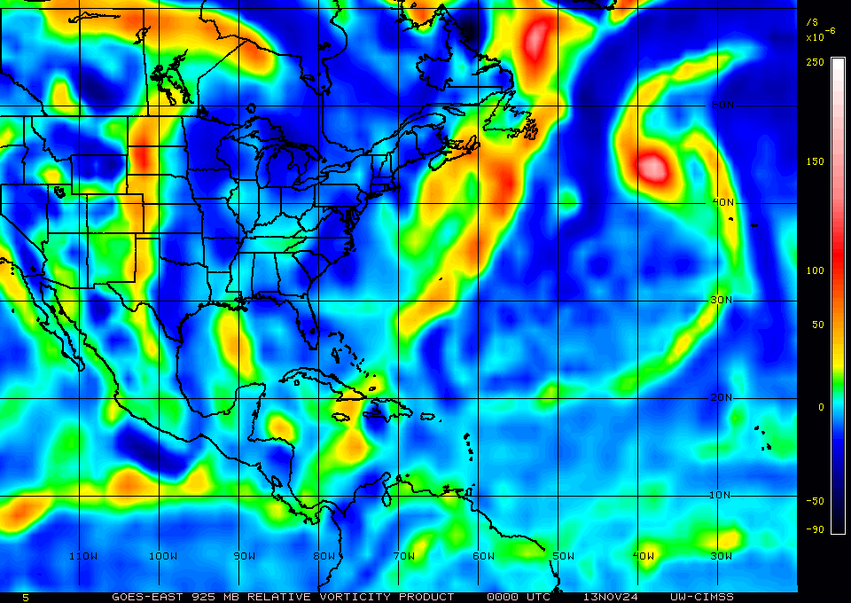
GFS actually seems to have a really good handle on this right now, with some complex center shenanigans happening over the course of the next day until it gets properly defined. At 6z the GFS has the 500mb vort centered around 16.3N 81.3W. seems pretty reasonable from what we are seeing on satellite. surface vort is definitely still displaced to the west as evident by CIMSS analysis (see below). expect general drifting NE, then for it to dive NW as it feels the remains of the ridge over the SE before finally getting tugged to the north by that approaching trough / cutoff low.
i would absolutely expect the center to jump and do weird things over the next day or so as it consolidates, but the GFS has had a good grasp on it that so far. if a dominant LLC does ends up consolidating, say half a degree of longitude to the east, then it may end up impacting future track. we have definitely seen that happen in the past, and it could happen here. track speculation still not all that useful until recon gets in there tomorrow and gets a fix.
i would absolutely expect the center to jump and do weird things over the next day or so as it consolidates, but the GFS has had a good grasp on it that so far. if a dominant LLC does ends up consolidating, say half a degree of longitude to the east, then it may end up impacting future track. we have definitely seen that happen in the past, and it could happen here. track speculation still not all that useful until recon gets in there tomorrow and gets a fix.
3 likes
B.S. Meteorology from Florida State '24 // Current M.S. Meteorology student at Florida State
Research Interests: Rapid Intensification, TC Climatology, TC Modeling
Consult the NHC for official information
Research Interests: Rapid Intensification, TC Climatology, TC Modeling
Consult the NHC for official information
-
TomballEd
- Category 5
- Posts: 1260
- Age: 62
- Joined: Wed Aug 16, 2023 4:52 pm
- Location: Spring/Klein area, not Tomball
Re: ATL: INVEST 97L - Discussion
TomballEd wrote:REDHurricane wrote:https://i.ibb.co/YdvtXhT/97-LGIIIFFF.jpg
The SSD site used to have a shortwave IR with blue coloring to the taller cloud tops, which made seeing low level flow pretty clearly (not as clear as visible, obviously)
Not sure I can make a gif
https://tropic.ssec.wisc.edu/real-time/storm.php?&basin=atlantic&sname=97L&invest=YES&zoom=4&img=1&vars=111110000000000000000000&loop=0&llval=OFF
0 likes

Re: ATL: INVEST 97L - Discussion
Salute!
Not looking good for the Panhandle, at least the Panama City and eastward shore.
I have vibes from way back this time of year with Opal. And then, just a few years back we had Michael. Both in early October.
I do not wish harm on anyone, but a landfall in the big bend seems to be the "optimum" as far as property damage and loss of life. But still a problem for the east side of the storm as another poster mentions.
Gums sends...
2 likes
-
CrazyC83
- Professional-Met

- Posts: 34315
- Joined: Tue Mar 07, 2006 11:57 pm
- Location: Deep South, for the first time!
Re: ATL: INVEST 97L - Discussion
Gums wrote:Salute!
Not looking good for the Panhandle, at least the Panama City and eastward shore.
I have vibes from way back this time of year with Opal. And then, just a few years back we had Michael. Both in early October.
I do not wish harm on anyone, but a landfall in the big bend seems to be the "optimum" as far as property damage and loss of life. But still a problem for the east side of the storm as another poster mentions.
Gums sends...
Although this is late September, the overall pattern is not too dissimilar.
The only good thing about the Big Bend is that it is the most sparsely populated part of the Florida coast. But a storm potentially stronger than Idalia would be an issue either way.
Last edited by CrazyC83 on Sun Sep 22, 2024 10:02 pm, edited 1 time in total.
2 likes
-
StPeteMike

- Category 2

- Posts: 653
- Joined: Thu Jun 07, 2018 11:26 pm
Re: ATL: INVEST 97L - Discussion
Gums wrote:Salute!
Not looking good for the Panhandle, at least the Panama City and eastward shore.
I have vibes from way back this time of year with Opal. And then, just a few years back we had Michael. Both in early October.
I do not wish harm on anyone, but a landfall in the big bend seems to be the "optimum" as far as property damage and loss of life. But still a problem for the east side of the storm as another poster mentions.
Gums sends...
Nerves are high for me. Luckily Debby was not a major storm, but Idalia was and I hoping it wouldn’t pull a Charley/Irma and go right “out of the blue”. Not great for the Big Bend area, but it was a sigh of relief to see it go beyond Pasco and not make a turn.
Even if a landfall in Big Bend, storm will be big enough to again deliver storm surge along the Tampa Bay coast of 4+ feet.
2 likes
The above post is not official and should not be used as such. It is the opinion of the poster and may or may not be backed by sound meteorological data. It is not endorsed by any professional institution or storm2k.org. For official information, please refer to the NHC and NWS products.
-
SFLcane

- S2K Supporter

- Posts: 10281
- Age: 48
- Joined: Sat Jun 05, 2010 1:44 pm
- Location: Lake Worth Florida
Re: ATL: INVEST 97L - Discussion
REDHurricane wrote:https://i.ibb.co/YdvtXhT/97-LGIIIFFF.jpg
Nothing there…
https://x.com/derrickherndon2/status/1838045326634045642
1 likes
-
REDHurricane

- Category 1
- Posts: 438
- Age: 28
- Joined: Sun Jul 03, 2022 2:36 pm
- Location: Northeast Pacific Ocean
Re: ATL: INVEST 97L - Discussion
Ian2401 wrote:GFS actually seems to have a really good handle on this right now, with some complex center shenanigans happening over the course of the next day until it gets properly defined. At 6z the GFS has the 500mb vort centered around 16.3N 81.3W. seems pretty reasonable from what we are seeing on satellite. surface vort is definitely still displaced to the west as evident by CIMSS analysis (see below). expect general drifting NE, then for it to dive NW as it feels the remains of the ridge over the SE before finally getting tugged to the north by that approaching trough / cutoff low.
i would absolutely expect the center to jump and do weird things over the next day or so as it consolidates, but the GFS has had a good grasp on it that so far. if a dominant LLC does ends up consolidating, say half a degree of longitude to the east, then it may end up impacting future track. we have definitely seen that happen in the past, and it could happen here. track speculation still not all that useful until recon gets in there tomorrow and gets a fix.
https://tropic.ssec.wisc.edu/real-time/atlantic/winds/wg8vor5.GIF
Here's where the pattern recognition part of my brain thinks the LLC might try to consolidate over the next several hours or so:

1 likes
-
DunedinDave
- Category 1
- Posts: 269
- Joined: Fri Aug 25, 2023 10:31 am
Re: ATL: INVEST 97L - Discussion
StPeteMike wrote:Gums wrote:Salute!
Not looking good for the Panhandle, at least the Panama City and eastward shore.
I have vibes from way back this time of year with Opal. And then, just a few years back we had Michael. Both in early October.
I do not wish harm on anyone, but a landfall in the big bend seems to be the "optimum" as far as property damage and loss of life. But still a problem for the east side of the storm as another poster mentions.
Gums sends...
Nerves are high for me. Luckily Debby was not a major storm, but Idalia was and I hoping it wouldn’t pull a Charley/Irma and go right “out of the blue”. Not great for the Big Bend area, but it was a sigh of relief to see it go beyond Pasco and not make a turn.
Even if a landfall in Big Bend, storm will be big enough to again deliver storm surge along the Tampa Bay coast of 4+ feet.
My concern in Pinellas is rain. While I feel better about avoiding the brutal winds from this thing, 5-7 inches of rain plus a storm surge on an already incredibly saturated ground is going to cause massive flooding around the Bay. Debby dumped a foot of rain in my neighborhood and a wet summer on top of that has made it a mess around here.
2 likes
-
Ian2401
- Category 1
- Posts: 321
- Joined: Thu Sep 14, 2017 5:55 pm
- Location: Tallahassee, Florida
- Contact:
Re: ATL: INVEST 97L - Discussion
REDHurricane wrote:Ian2401 wrote:GFS actually seems to have a really good handle on this right now, with some complex center shenanigans happening over the course of the next day until it gets properly defined. At 6z the GFS has the 500mb vort centered around 16.3N 81.3W. seems pretty reasonable from what we are seeing on satellite. surface vort is definitely still displaced to the west as evident by CIMSS analysis (see below). expect general drifting NE, then for it to dive NW as it feels the remains of the ridge over the SE before finally getting tugged to the north by that approaching trough / cutoff low.
i would absolutely expect the center to jump and do weird things over the next day or so as it consolidates, but the GFS has had a good grasp on it that so far. if a dominant LLC does ends up consolidating, say half a degree of longitude to the east, then it may end up impacting future track. we have definitely seen that happen in the past, and it could happen here. track speculation still not all that useful until recon gets in there tomorrow and gets a fix.
https://tropic.ssec.wisc.edu/real-time/atlantic/winds/wg8vor5.GIF
Here's where the pattern recognition part of my brain thinks the LLC might try to consolidate over the next several hours or so:
https://i.ibb.co/MPncYR1/97-L-picture.jpg
not bad thinking. might have already happened. would line up more or less with what the gfs is showing by ~12z tmrw. just won't know for sure until recon gets there or at the very least until daylight and we can better see low level cloud motion
1 likes
B.S. Meteorology from Florida State '24 // Current M.S. Meteorology student at Florida State
Research Interests: Rapid Intensification, TC Climatology, TC Modeling
Consult the NHC for official information
Research Interests: Rapid Intensification, TC Climatology, TC Modeling
Consult the NHC for official information
-
StPeteMike
- Category 2
- Posts: 653
- Joined: Thu Jun 07, 2018 11:26 pm
Re: ATL: INVEST 97L - Discussion
DunedinDave, I feel ya! It was crazy to just have an evening storm cause so much flooding on 4th Street and other major streets down here in St. Pete.
If we get something worse than expected, will not be great down here. I drove through Shore Acres yesterday and there was so many Open House signs posted. Take a trip on Zillow in that area, it will cause a major disruption in housing in the city.
If we get something worse than expected, will not be great down here. I drove through Shore Acres yesterday and there was so many Open House signs posted. Take a trip on Zillow in that area, it will cause a major disruption in housing in the city.
2 likes
The above post is not official and should not be used as such. It is the opinion of the poster and may or may not be backed by sound meteorological data. It is not endorsed by any professional institution or storm2k.org. For official information, please refer to the NHC and NWS products.
-
SouthFLTropics

- Category 5
- Posts: 4258
- Age: 50
- Joined: Thu Aug 14, 2003 8:04 am
- Location: Port St. Lucie, Florida
Re: ATL: INVEST 97L - Discussion
I’m not 100 percent sold on the estimated center location and whether that is where this is going to set up shop. That convection off to the east looks very substantial and I’m of the John Hope Old School of follow the convection.
Sent from my iPhone using Tapatalk
Sent from my iPhone using Tapatalk
4 likes
Fourth Generation Florida Native
Personal Storm History: David 79, Andrew 92, Erin 95, Floyd 99, Irene 99, Frances 04, Jeanne 04, Wilma 05, Matthew 16, Irma 17, Ian 22, Nicole 22, Milton 24
Personal Storm History: David 79, Andrew 92, Erin 95, Floyd 99, Irene 99, Frances 04, Jeanne 04, Wilma 05, Matthew 16, Irma 17, Ian 22, Nicole 22, Milton 24
-
weeniepatrol

- Category 5
- Posts: 1340
- Joined: Sat Aug 22, 2020 5:30 pm
- Location: WA State
Re: ATL: INVEST 97L - Discussion
CIMSS and best track still show the low level vorticity centered close to 83 West; the mid center and all the deep convection is centered along 80 West. Substantial vertical tilt with height, but this is very common in nascent systems. We will see if the centers align or the surface center reforms under the convection or w/e. Recon tomorrow invaluable in assessing vertical coherency.
1 likes
Who is online
Users browsing this forum: No registered users and 23 guests