
ATL: DEBBY - Models
Moderator: S2k Moderators

Re: ATL: FOUR - Models
BobHarlem wrote:41% chance of RI with four
https://i.imgur.com/FvLOGvK.jpeg
Ships missing that offshore Atlantic potential keeping it a TS?
Last edited by Steve on Fri Aug 02, 2024 9:39 pm, edited 1 time in total.
0 likes
Re: ATL: FOUR - Models
Also FV3 north of Tampa but disorganized. Not sure if it doesn’t catch the origins or if it’s on to something. I like it farther north but this is a good test to see if it candle something coming up from the Caribbean which is out of range.
1 likes
Re: ATL: FOUR - Models
FV3 with the Big Bend hit and 970s cat 2 and still way south of Myrtle beach in 120 hours/5 days.
https://www.tropicaltidbits.com/analysi ... 218&fh=120
Next up icon.
https://www.tropicaltidbits.com/analysi ... 218&fh=120
Next up icon.
0 likes
Re: ATL: FOUR - Models
0z icon landfall Big Bend between Perry and St. Marks

Exits into Atlantic near Brunswick/St. SImons Island, GA

Second landfall near Hilton Head Island, SC

Then moves slowly inland into North Carolina by Saturday, and appears to be heading back out into the Atlantic by the end of the run (Close to the NC/VA line by the coast)
Exits into Atlantic near Brunswick/St. SImons Island, GA
Second landfall near Hilton Head Island, SC
Then moves slowly inland into North Carolina by Saturday, and appears to be heading back out into the Atlantic by the end of the run (Close to the NC/VA line by the coast)
1 likes
-
StPeteMike

- Category 2

- Posts: 657
- Joined: Thu Jun 07, 2018 11:26 pm
Re: ATL: FOUR - Models
Boy, coastal flooding will be bad for West Coast to Nature Coast of Florida and much of GA/SC/NC with those models and the lack of speed.
1 likes
The above post is not official and should not be used as such. It is the opinion of the poster and may or may not be backed by sound meteorological data. It is not endorsed by any professional institution or storm2k.org. For official information, please refer to the NHC and NWS products.
-
AtlanticWind

- S2K Supporter

- Posts: 1898
- Age: 67
- Joined: Sun Aug 08, 2004 9:57 pm
- Location: Plantation,Fla
Re: ATL: FOUR - Models
Landfall here near Steinhatchee, however I think it may be underestimating intensity just on looking at satellite now.
Landfall point is only slightly left of 18z, but takes about 6 hours longer to get on land, so moving generally slower than 18z.

Exits into the Atlantic around Brunswick/ST. Simons, similar location as 18z, but again moving slower, then hugs the coast offshore, moving like a herd of turtles. Much closer to shore than the 18z. Coastal Flooding/surge going to be a big problem with this one.

Landfall point is only slightly left of 18z, but takes about 6 hours longer to get on land, so moving generally slower than 18z.
Exits into the Atlantic around Brunswick/ST. Simons, similar location as 18z, but again moving slower, then hugs the coast offshore, moving like a herd of turtles. Much closer to shore than the 18z. Coastal Flooding/surge going to be a big problem with this one.
1 likes
-
Stratton23
- Category 5

- Posts: 3573
- Joined: Fri Jul 21, 2023 10:59 pm
- Location: Katy, Tx
Re: ATL: FOUR - Models
Models are trending stronger with the bermuda high, don’t think its going to ride up the coast any more, I think it stalls somewhere off the georgia coast before moving back in land
4 likes
Re: ATL: FOUR - Models
0z gfs Second landfall between Charleston, SC and Georgetown

Then exits by Norfolk, VA, skirting MD, DE, NJ.

Third landfall eastern Long Island, NY, with a quick 4th in Rhode Island/MA, then a 5th in Nova Scotia.

Then exits by Norfolk, VA, skirting MD, DE, NJ.
Third landfall eastern Long Island, NY, with a quick 4th in Rhode Island/MA, then a 5th in Nova Scotia.
0 likes
-
Spacecoast

- Category 2
- Posts: 773
- Joined: Thu Aug 31, 2017 2:03 pm
Re: ATL: FOUR - Models
What a tangled mess.....

Super-ensemble (GFS,Euro,GEFS,EPS,etc,etc)
zoom...

Super-ensemble (GFS,Euro,GEFS,EPS,etc,etc)
zoom...
Last edited by Spacecoast on Fri Aug 02, 2024 11:48 pm, edited 1 time in total.
0 likes
Re: ATL: FOUR - Models
0Z UK: landfall just E of 12Z’s Apalachicola; then goes inland further W into C GA then turns E to CHS, goes up SC coast and then well inland into NC; flooding threat many areas:
NEW TROPICAL CYCLONE FORECAST TO DEVELOP AFTER 24 HOURS
FORECAST POSITION AT T+ 24 : 23.5N 83.7W
LEAD CENTRAL MAXIMUM WIND
VERIFYING TIME TIME POSITION PRESSURE (MB) SPEED (KNOTS)
-------------- ---- -------- ------------- -------------
0000UTC 04.08.2024 24 23.5N 83.7W 1007 28
1200UTC 04.08.2024 36 25.7N 84.8W 1006 34
0000UTC 05.08.2024 48 27.4N 85.5W 1004 43
1200UTC 05.08.2024 60 28.8N 85.3W 1003 42
0000UTC 06.08.2024 72 29.9N 84.4W 1002 35
1200UTC 06.08.2024 84 31.4N 84.2W 1001 36
0000UTC 07.08.2024 96 32.5N 83.3W 997 37
1200UTC 07.08.2024 108 32.5N 81.1W 996 41
0000UTC 08.08.2024 120 32.8N 79.9W 994 43
1200UTC 08.08.2024 132 33.8N 79.5W 996 41
0000UTC 09.08.2024 144 35.3N 78.4W 998 39
1200UTC 09.08.2024 156 36.4N 78.5W 1001 38
0000UTC 10.08.2024 168 37.4N 76.6W 1002 36
0 likes
Personal Forecast Disclaimer:
The posts in this forum are NOT official forecasts and should not be used as such. They are just the opinion of the poster and may or may not be backed by sound meteorological data. They are NOT endorsed by any professional institution or storm2k.org. For official information, please refer to the NHC and NWS products.
The posts in this forum are NOT official forecasts and should not be used as such. They are just the opinion of the poster and may or may not be backed by sound meteorological data. They are NOT endorsed by any professional institution or storm2k.org. For official information, please refer to the NHC and NWS products.
-
Stratton23
- Category 5
- Posts: 3573
- Joined: Fri Jul 21, 2023 10:59 pm
- Location: Katy, Tx
Re: ATL: FOUR - Models
GEFS doesn’t fully agree with a ride up the east coast and stall, still is very split, with a 2nd group still hanging back in the gulf of mexico, this is a nightmare to forecast
0 likes
Re: ATL: FOUR - Models
0Z Euro: similar track to 12Z but stronger with it coming back into CHS at 986 mb vs 989 on 12Z; biblical rainfall amts of 20-24” mainly over ~72 hr period SAV-CHS and inland to 50 miles Lowcountry
0 likes
Personal Forecast Disclaimer:
The posts in this forum are NOT official forecasts and should not be used as such. They are just the opinion of the poster and may or may not be backed by sound meteorological data. They are NOT endorsed by any professional institution or storm2k.org. For official information, please refer to the NHC and NWS products.
The posts in this forum are NOT official forecasts and should not be used as such. They are just the opinion of the poster and may or may not be backed by sound meteorological data. They are NOT endorsed by any professional institution or storm2k.org. For official information, please refer to the NHC and NWS products.
-
ElectricStorm

- Category 5
- Posts: 5152
- Age: 25
- Joined: Tue Aug 13, 2019 11:23 pm
- Location: Norman, OK
Re: ATL: FOUR - Models
0z Hurricane models:
HWRF gets to 70kts/983mb at landfall.
HMON 60kts/986mb shortly before landfall
HAFS-A 70kts/985mb
HAFS-B the weakest but still a strong TS at 60kts/992mb
Still looks to be on pace for a strong TS/low end Cat 1 at landfall. NHCs forecast looks pretty good for now, as long as it doesn't end up further west. If that happens it might get a bit stronger.
0 likes
B.S Meteorology, University of Oklahoma '25
Please refer to the NHC, NWS, or SPC for official information.
Please refer to the NHC, NWS, or SPC for official information.

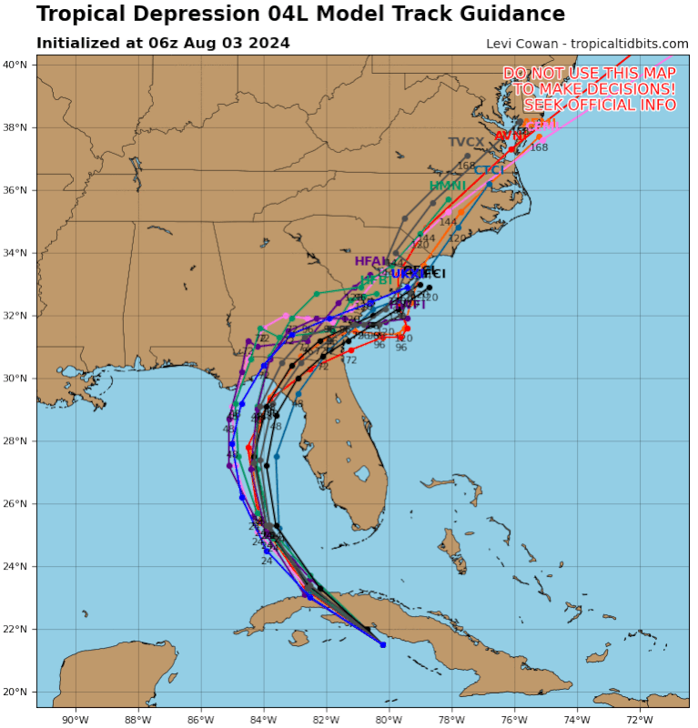
Re: ATL: FOUR - Models
This might be one of the toughest forecast challenges I've seen in recent times. Where this is headed after Florida is a big question. A look at the GEFS ensembles at 7 days shows three groups. Some show members riding the Gulf stream north to either New England or Canada. Others show pretty much a complete stall, which would not be ideal for the south east, (although the wind threat isn't as likely to be a problem in these runs with most staying inland). Finally, there's a small outlier group of members where they somehow end up in Texas‽ There's a lot of wrinkles in these forecasts.
0 likes
-
jlauderdal
- S2K Supporter
- Posts: 7240
- Joined: Wed May 19, 2004 5:46 am
- Location: NE Fort Lauderdale
- Contact:
Re: ATL: FOUR - Models
Woofde wrote:This might be one of the toughest forecast challenges I've seen in recent times. Where this is headed after Florida is a big question. A look at the GEFS ensembles at 7 days shows three groups. Some show members riding the Gulf stream north to either New England or Canada. Others show pretty much a complete stall, which would not be ideal for the south east, (although the wind threat isn't as likely to be a problem in these runs with most staying inland). Finally, there's a small outlier group of members where they somehow end up in Texas‽ There's a lot of wrinkles in these forecasts.https://uploads.tapatalk-cdn.com/20240803/bf3de921612e3be14a5714fe80c49639.jpg
The euro has a prolonged stall over NC/SC, still there a week from today, that looks like a far bigger issue than Florida will see. Dont fall asleep on the wave train, its loading up as we get into peak season, a setup that will make those season cancel posts a faded memory.
0 likes

Re: ATL: FOUR - Models
Stratton23 wrote:GEFS doesn’t fully agree with a ride up the east coast and stall, still is very split, with a 2nd group still hanging back in the gulf of mexico, this is a nightmare to forecast
00z GFS is still too fast but the Euro track might verify if the current slow movement doesn't continue.
The trough to the north is much clearer in the water vapor loop this morning but our TS is still south of Cuba!
If this were October we could hope the trough digs farther south than forecast but the prospects for an an early miss might start showing up in the next few model runs?
0 likes

-
jlauderdal
- S2K Supporter
- Posts: 7240
- Joined: Wed May 19, 2004 5:46 am
- Location: NE Fort Lauderdale
- Contact:
Who is online
Users browsing this forum: No registered users and 77 guests