ATL: KIRK - Post-Tropical - Discussion
Moderator: S2k Moderators

Re: ATL: KIRK - Hurricane - Discussion: Special Advisory= Skips Cat 2 / Up to Cat 3 at 105kt
I would not be surprised if Kirk becomes a Category 5 hurricane.
1 likes
Re: ATL: KIRK - Hurricane - Discussion: Special Advisory= Skips Cat 2 / Up to Cat 3 at 105kt
CrazyC83 wrote:Makes me wonder, could we see a major MDR hurricane in November at this rate?
(Has there ever been anything out there in November before, of any intensity?)
Nothing would surprise me.
0 likes

Re: ATL: KIRK - Hurricane - Discussion: Special Advisory= Skips Cat 2 / Up to Cat 3 at 105kt
weeniepatrol wrote:CrazyC83 wrote:aspen wrote:Was gonna point that out lol. Such a weird double-peaked season.
2024 might take it a step further and have a MDR-born Cat 5 in July and October at opposite ends of the basin but none during August or September.
That almost has a North Indian Ocean feel in a sense. Not much was happening at all during the peak season, but the shoulder seasons are getting the activity...
Yeah I saw and participated in much debate on Twitter regarding potential "Indian Oceanification" of the Atlantic due to climate change. I'm not sure I believe it, but it is an interesting theory
Probably too early to tell. This year’s anomalous double-peak can be tied to the northerly-displaced ITCZ that shut down normal climo peak; significant MDR activity only occurred when the ITCZ was at favorable latitudes during the “shoulder seasons”. It’s possible that changing ocean/atmospheric currents (ex: cooling waters by Greenland due to ice melt) could drag the ITCZ north on a more regular basis, but we have far too small of a sample size to say anything definitive.
5 likes
Irene '11 Sandy '12 Hermine '16 5/15/2018 Derecho Fay '20 Isaias '20 Elsa '21 Henri '21 Ida '21
I am only a meteorology enthusiast who knows a decent amount about tropical cyclones. Look to the professional mets, the NHC, or your local weather office for the best information.
I am only a meteorology enthusiast who knows a decent amount about tropical cyclones. Look to the professional mets, the NHC, or your local weather office for the best information.
-
xtyphooncyclonex

- Category 5

- Posts: 3900
- Age: 24
- Joined: Sat Dec 08, 2012 9:07 am
- Location: Cebu City
- Contact:
Re: ATL: KIRK - Hurricane - Discussion: Special Advisory= Skips Cat 2 / Up to Cat 3 at 105kt
Knew that 105-110 kt forecast was quite conservative. This feels like a budding WPac super typhoon.
5 likes
REMINDER: My opinions that I, or any other NON Pro-Met in this forum, are unofficial. Please do not take my opinions as an official forecast and warning. I am NOT a meteorologist. Following my forecasts blindly may lead to false alarm, danger and risk if official forecasts from agencies are ignored.

Re: ATL: KIRK - Hurricane - Discussion: Special Advisory= Skips Cat 2 / Up to Cat 3 at 105kt
Actually, forget about easternmost records or what might happen in November.
If we define the MDR as east of 60W (not the Caribbean) and south of 25N (very lenient definition), there were only two other October MHs in the MDR on record: #10 1878 and #9 1893. Both peaked at 100-105 kts.
Kirk is the only MDR major hurricane in October in the satellite era. It looks destined to become the only MDR Cat 4 in October, period.
4 likes
TC naming lists: retirements and intensity
Most aggressive Advisory #1's in North Atlantic (cr. kevin for starting the list)
Most aggressive Advisory #1's in North Atlantic (cr. kevin for starting the list)
Re: ATL: KIRK - Hurricane - Discussion: Special Advisory= Skips Cat 2 / Up to Cat 3 at 105kt
xtyphooncyclonex wrote:Knew that 105-110 kt forecast was quite conservative. This feels like a budding WPac super typhoon.
To be fair, even the typically aggressive hurricane models were showing 110 kt peaks for days. Kirk is massively outperforming even the most aggressive model expectations.
1 likes
TC naming lists: retirements and intensity
Most aggressive Advisory #1's in North Atlantic (cr. kevin for starting the list)
Most aggressive Advisory #1's in North Atlantic (cr. kevin for starting the list)
-
Hypercane_Kyle

- Category 5
- Posts: 3465
- Joined: Sat Mar 07, 2015 7:58 pm
- Location: Cape Canaveral, FL
Re: ATL: KIRK - Hurricane - Discussion: Special Advisory= Skips Cat 2 / Up to Cat 3 at 105kt
Teban54 wrote:Actually, forget about easternmost records or what might happen in November.
If we define the MDR as east of 60W (not the Caribbean) and south of 25N (very lenient definition), there were only two other October MHs in the MDR on record: #10 1878 and #9 1893. Both peaked at 100-105 kts.
Kirk is the only MDR major hurricane in October in the satellite era. It looks destined to become the only MDR Cat 4 in October, period.
2024 has the earliest MDR major and latest, but no MDR major hurricanes in between. Sounds about right.
6 likes
My posts are my own personal opinion, defer to the National Hurricane Center (NHC) and other NOAA products for decision making during hurricane season.
-
cycloneye

- Admin

- Posts: 149720
- Age: 69
- Joined: Thu Oct 10, 2002 10:54 am
- Location: San Juan, Puerto Rico
Re: ATL: KIRK - Hurricane - Discussion: Special Advisory= Skips Cat 2 / Up to Cat 3 at 105kt
1 likes
Visit the Caribbean-Central America Weather Thread where you can find at first post web cams,radars
and observations from Caribbean basin members Click Here
and observations from Caribbean basin members Click Here
-
Category5Kaiju

- Category 5
- Posts: 4346
- Joined: Thu Dec 24, 2020 12:45 pm
- Location: Seattle during the summer, Phoenix during the winter
Re: ATL: KIRK - Hurricane - Discussion: Special Advisory= Skips Cat 2 / Up to Cat 3 at 105kt
You know, something I've noticed is that in recent years, it seems like we've had quite a few Cape Verde hurricanes that were on the cusp of Category 5 (Sam) and bona fide Category 5s (Lorenzo and Lee) recurve. And Kirk looks somewhat likely to join this list of recurving very high-end Cat 4/Cat 5 hurricanes.
4 likes
Unless explicitly stated, all information in my posts is based on my own opinions and observations. Tropical storms and hurricanes can be extremely dangerous. Refer to an accredited weather research agency or meteorologist if you need to make serious decisions regarding an approaching storm.
-
xtyphooncyclonex
- Category 5
- Posts: 3900
- Age: 24
- Joined: Sat Dec 08, 2012 9:07 am
- Location: Cebu City
- Contact:
Re: ATL: KIRK - Hurricane - Discussion: Special Advisory= Skips Cat 2 / Up to Cat 3 at 105kt
Teban54 wrote:Actually, forget about easternmost records or what might happen in November.
If we define the MDR as east of 60W (not the Caribbean) and south of 25N (very lenient definition), there were only two other October MHs in the MDR on record: #10 1878 and #9 1893. Both peaked at 100-105 kts.
Kirk is the only MDR major hurricane in October in the satellite era. It looks destined to become the only MDR Cat 4 in October, period.
This season feels so unusual. If all goes well for lingering Leslie she may kiss Kirk's records goodbye too
4 likes
REMINDER: My opinions that I, or any other NON Pro-Met in this forum, are unofficial. Please do not take my opinions as an official forecast and warning. I am NOT a meteorologist. Following my forecasts blindly may lead to false alarm, danger and risk if official forecasts from agencies are ignored.
Re: ATL: KIRK - Hurricane - Discussion
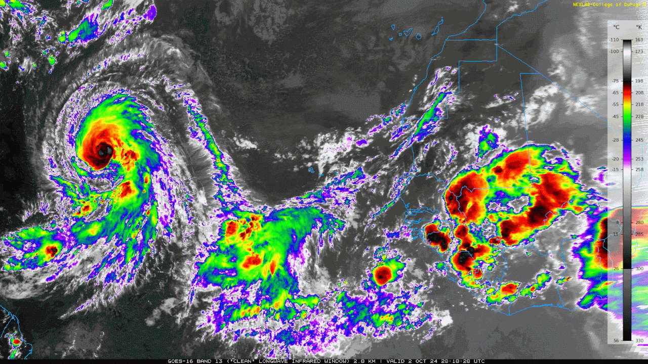
GOES public imagery has been down for at least half an hour again, but looking at up-to-date ones from COD, it looks like a bit of dry air got ingested. Probably only a minor hiccup, though. (Also note that COD uses a different color scale.)
2 likes
TC naming lists: retirements and intensity
Most aggressive Advisory #1's in North Atlantic (cr. kevin for starting the list)
Most aggressive Advisory #1's in North Atlantic (cr. kevin for starting the list)
-
WaveBreaking

- Category 2

- Posts: 728
- Joined: Sun Jun 30, 2024 11:33 am
- Location: US
Re: ATL: KIRK - Hurricane - Discussion
Teban54 wrote:GOES public imagery has been down for at least half an hour again, but looking at up-to-date ones from COD, it looks like a bit of dry air got ingested. Probably only a minor hiccup, though. (Also note that COD uses a different color scale.)
https://i.postimg.cc/0N3yCvyT/CODNEXLAB-GOES-East-global-capeverde-13-02-10-Z-20241003-map-data-36-1n-10-100.gif
If you look over at the weak thunderstorms near 50W 20N, you can see their anvils getting blown off to the east. So there might be a bit of mid-level shear nearby that’s helping the dry air to get in. But it shouldn’t be enough to take down Kirk imo. It looks like it’s building a thick eyewall atm.

1 likes
I am NOT a professional meteorologist, so take all of my posts with a grain of salt. My opinions are mine and mine alone.
-
weeniepatrol

- Category 5
- Posts: 1345
- Joined: Sat Aug 22, 2020 5:30 pm
- Location: WA State
Re: ATL: KIRK - Hurricane - Discussion: Special Advisory= Skips Cat 2 / Up to Cat 3 at 105kt
aspen wrote:weeniepatrol wrote:CrazyC83 wrote:
That almost has a North Indian Ocean feel in a sense. Not much was happening at all during the peak season, but the shoulder seasons are getting the activity...
Yeah I saw and participated in much debate on Twitter regarding potential "Indian Oceanification" of the Atlantic due to climate change. I'm not sure I believe it, but it is an interesting theory
Probably too early to tell. This year’s anomalous double-peak can be tied to the northerly-displaced ITCZ that shut down normal climo peak; significant MDR activity only occurred when the ITCZ was at favorable latitudes during the “shoulder seasons”. It’s possible that changing ocean/atmospheric currents (ex: cooling waters by Greenland due to ice melt) could drag the ITCZ north on a more regular basis, but we have far too small of a sample size to say anything definitive.
Exactly. Agree.
0 likes
Re: ATL: KIRK - Hurricane - Discussion
WaveBreaking wrote:Teban54 wrote:GOES public imagery has been down for at least half an hour again, but looking at up-to-date ones from COD, it looks like a bit of dry air got ingested. Probably only a minor hiccup, though. (Also note that COD uses a different color scale.)
https://i.postimg.cc/0N3yCvyT/CODNEXLAB-GOES-East-global-capeverde-13-02-10-Z-20241003-map-data-36-1n-10-100.gif
If you look over at the weak thunderstorms near 50W 20N, you can see their anvils getting blown off to the east. So there might be a bit of mid-level shear nearby that’s helping the dry air to get in. But it shouldn’t be enough to take down Kirk imo. It looks like it’s building a thick eyewall atm.
https://i.imgur.com/4rfY88C.gif
NHC upped Kirk to 110 kt at this advisory despite the possible dry air entrainment (which means it might also just be an illusion). New forecast has peak 130 kt.
Kirk has undergone an impressive period of rapid intensification
over the past 24 h. Recent satellite imagery showed a ragged eye,
with multiple deep bursts of convection rotating in the eyewall.
Overshooting tops are obscuring the eye now, but it would not be
surprising if it clears again soon. As noted in the special
advisory, the subjective Dvorak satellite estimates have climbed but
were constrained. The initial intensity is nudged up to 110 kt for
this advisory, closest to the T6.0 data-T number from SAB. The
hurricane has strengthened 55 kt since 0300 UTC last night, which
means Kirk lands at a Category 3 on the Saffir-Simpson scale.
3 likes
TC naming lists: retirements and intensity
Most aggressive Advisory #1's in North Atlantic (cr. kevin for starting the list)
Most aggressive Advisory #1's in North Atlantic (cr. kevin for starting the list)
-
cheezyWXguy

- Category 5
- Posts: 6282
- Joined: Mon Feb 13, 2006 12:29 am
- Location: Dallas, TX
Re: ATL: KIRK - Hurricane - Discussion
Starting to wrap around deeper convection and eye warming again. We’ll see if it lasts this time.
0 likes

Re: ATL: KIRK - Hurricane - Discussion
Kirk's eye is warming, now up to +6C. Constraints from ADT have been removed and CI# is climbing. It's currently at 5.2, but the raw T# of 5.9 supports an intensity of 950mb/112kt.
0 likes
Re: ATL: KIRK - Hurricane - Discussion
Well that’s disappointing. Looks like it leveled off for some reason, which wasn’t forecast by the hurricane models.
0 likes
Irene '11 Sandy '12 Hermine '16 5/15/2018 Derecho Fay '20 Isaias '20 Elsa '21 Henri '21 Ida '21
I am only a meteorology enthusiast who knows a decent amount about tropical cyclones. Look to the professional mets, the NHC, or your local weather office for the best information.
I am only a meteorology enthusiast who knows a decent amount about tropical cyclones. Look to the professional mets, the NHC, or your local weather office for the best information.
Re: ATL: KIRK - Hurricane - Discussion
Kirk has ingested a bit of dry air which has disrupted the eye in the last few hours , Kirk is in an area of dry air or it might of been a eyewall replacement. This is a 3 hour loop of Kirk using GeoColor Proxy and Tropical Airmass (thats why its pink) to show details of Kirk.
Source - https://col.st/IJ32i

Source - https://col.st/IJ32i
2 likes
-
Hurricane2022

- Category 5
- Posts: 2092
- Joined: Tue Aug 23, 2022 11:38 pm
- Location: Araçatuba, Brazil
Re: ATL: KIRK - Hurricane - Discussion
EWRC?


0 likes
Sorry for the bad English sometimes...!
For reliable and detailed information for any meteorological phenomenon, please consult the National Hurricane Center, Joint Typhoon Warning Center , or your local Meteo Center.
--------
ECCE OMNIA NOVA FACIAM (Ap 21,5).
For reliable and detailed information for any meteorological phenomenon, please consult the National Hurricane Center, Joint Typhoon Warning Center , or your local Meteo Center.
--------
ECCE OMNIA NOVA FACIAM (Ap 21,5).
Re: ATL: KIRK - Hurricane - Discussion
Based on the latest frames, I’m not sure. May just be a consequence of the dry air entrainment and convective bands trying to wall it off.
0 likes
Irene '11 Sandy '12 Hermine '16 5/15/2018 Derecho Fay '20 Isaias '20 Elsa '21 Henri '21 Ida '21
I am only a meteorology enthusiast who knows a decent amount about tropical cyclones. Look to the professional mets, the NHC, or your local weather office for the best information.
I am only a meteorology enthusiast who knows a decent amount about tropical cyclones. Look to the professional mets, the NHC, or your local weather office for the best information.
Who is online
Users browsing this forum: No registered users and 41 guests