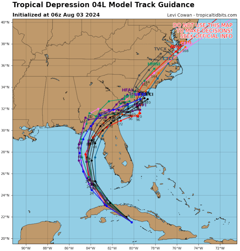
Check date/position that graphic is glitched using yesterday's 12z.
ATL: DEBBY - Models
Moderator: S2k Moderators
-
SFLcane

- S2K Supporter

- Posts: 10281
- Age: 48
- Joined: Sat Jun 05, 2010 1:44 pm
- Location: Lake Worth Florida
Re: ATL: FOUR - Models
jlauderdal wrote:
Breeze has picked up in sofla, precip looks meager for now.
Still south of Cuba ways away still closest approach is not till tonight. 12z models could bring the flooding totals back up for SFL.
1 likes
Re: ATL: FOUR - Models
jlauderdal wrote:Woofde wrote:This might be one of the toughest forecast challenges I've seen in recent times. Where this is headed after Florida is a big question. A look at the GEFS ensembles at 7 days shows three groups. Some show members riding the Gulf stream north to either New England or Canada. Others show pretty much a complete stall, which would not be ideal for the south east, (although the wind threat isn't as likely to be a problem in these runs with most staying inland). Finally, there's a small outlier group of members where they somehow end up in Texas‽ There's a lot of wrinkles in these forecasts.https://uploads.tapatalk-cdn.com/20240803/bf3de921612e3be14a5714fe80c49639.jpg
The euro has a prolonged stall over NC/SC, still there a week from today, that looks like a far bigger issue than Florida will see. Dont fall asleep on the wave train, its loading up as we get into peak season, a setup that will make those season cancel posts a faded memory.
A prolonged stall looks like the most likely outcome. Between the Bermuda high and the ridge In the Midwest dipping down, Four just might drift around right off the FL/GA coast for days.
Of course, NONE of this takes into account that this thing could bomb out and intensify to a Cat 2 or 3 once it gets clear of Cuba and tastes that nice, warm bath water in the Gulf.
0 likes
Cleo - 1964, Betsy - 1965, David - 1979, Andrew - 1992, Charlie (Francis, Ivan, Jeanne) - 2004, Irma - 2017, Ian - 2022, Milton - 2024
-
SFLcane
- S2K Supporter
- Posts: 10281
- Age: 48
- Joined: Sat Jun 05, 2010 1:44 pm
- Location: Lake Worth Florida
Re: ATL: FOUR - Models
BobHarlem wrote:
Check date/position that graphic is glitched using yesterday's 12z.
This is correct it’s an error using yesterdays data.
Thanks for catching that. Going to back to sleep.
0 likes

Re: ATL: FOUR - Models
Michele B wrote:Of course, NONE of this takes into account that this thing could bomb out and intensify to a Cat 2 or 3 once it gets clear of Cuba and tastes that nice, warm bath water in the Gulf.
Take a look at the NAM 3k intensity, which should almost never be used for intensity. All the meso scale models should be not be trusted for tropical systems but they do often see short steering patterns changes before the hurricane model. While the intensity is bonkers, I do think they are picking up that the trough, despite being fairly weak, is helping spin up the storm.
I do think once this clears Cuba, future Debby will find itself in an environment very conducive for RI, the chances of a hurricane are pretty high now, this time yesterday we were thinking low end tropical storm. It seems like the Global models agree with this solution.
The extra ~24 hours over hot water in concerning. Almost hard to imagine how this ragged depression could evolve into a strong tropical storm in the next 24 hours.
1 likes
-
REDHurricane

- Category 1

- Posts: 438
- Age: 28
- Joined: Sun Jul 03, 2022 2:36 pm
- Location: Northeast Pacific Ocean
Re: ATL: FOUR - Models
Jr0d wrote:Take a look at the NAM 3k intensity, which should almost never be used for intensity. All the meso scale models should be not be trusted for tropical systems but they do often see short steering patterns changes before the hurricane model. While the intensity is bonkers, I do think they are picking up that the trough, despite being fairly weak, is helping spin up the storm.
I do think once this clears Cuba, future Debby will find itself in an environment very conducive for RI, the chances of a hurricane are pretty high now, this time yesterday we were thinking low end tropical storm. It seems like the Global models agree with this solution.
The extra ~24 hours over hot water in concerning. Almost hard to imagine how this ragged depression could evolve into a strong tropical storm in the next 24 hours.
Wait, are you trying to tell me that future Debby isn't going to experience an 80mb pressure drop in a 24 hour time period????

3 likes
Re: ATL: FOUR - Models
No change on 12z earlies for Florida, but yikes for Savannah/Hilton Head area.

0 likes
-
otowntiger
- Category 5

- Posts: 1932
- Joined: Tue Aug 31, 2004 7:06 pm
Re: ATL: FOUR - Models
BobHarlem wrote:No change on 12z earlies for Florida, but yikes for Savannah/Hilton Head area.
https://i.imgur.com/yqBdPrR.png
Just keeps nudging west. Tally could soon be in the crosshairs and the further west it goes the stronger and more consolidated it could get. Could it be a lot of the peninsula escapes serious effects?
0 likes
-
shannalynn35
- Tropical Wave

- Posts: 4
- Joined: Tue Sep 20, 2022 8:08 am
Re: ATL: FOUR - Models
Hi everyone! With your expertise does anyone see this possibly nudging back East and possibly making landfall near Tampa as opposed to the Big Bend area?
2 likes

Re: ATL: FOUR - Models
shannalynn35 wrote:Hi everyone! With your expertise does anyone see this possibly nudging back East and possibly making landfall near Tampa as opposed to the Big Bend area?
no if anything further west. the center relocated 20 miles more west hence the track more west. right now track wise we r looking at the storm staying 95 miles off west central coast of florida. so will go more west not east at this point.
0 likes
Robbielyn McCrary
I know just about enough to sound like I know what I'm talking about sometimes. But for your safety please follow the nhc for truly professional forecasting.
I know just about enough to sound like I know what I'm talking about sometimes. But for your safety please follow the nhc for truly professional forecasting.

Re: ATL: FOUR - Models
shannalynn35 wrote:Hi everyone! With your expertise does anyone see this possibly nudging back East and possibly making landfall near Tampa as opposed to the Big Bend area?
I don’t but it doesn’t mean there won’t be squalls and gust winds.
0 likes
-
DunedinDave
- Category 1
- Posts: 269
- Joined: Fri Aug 25, 2023 10:31 am
Re: ATL: FOUR - Models
shannalynn35 wrote:Hi everyone! With your expertise does anyone see this possibly nudging back East and possibly making landfall near Tampa as opposed to the Big Bend area?
Only way I think this happens is if the center relocates which can happen in disorganized systems like this. But I’m sure there are more expert opinions out there than mine.
0 likes
-
Stormlover70
- Tropical Storm

- Posts: 194
- Age: 56
- Joined: Fri Jun 21, 2024 5:31 am
- Location: New port richey
Re: ATL: FOUR - Models
Nhc is great on track. They struggle on intensityDunedinDave wrote:shannalynn35 wrote:Hi everyone! With your expertise does anyone see this possibly nudging back East and possibly making landfall near Tampa as opposed to the Big Bend area?
Only way I think this happens is if the center relocates which can happen in disorganized systems like this. But I’m sure there are more expert opinions out there than mine.
0 likes
-
cheezyWXguy

- Category 5
- Posts: 6282
- Joined: Mon Feb 13, 2006 12:29 am
- Location: Dallas, TX
Re: ATL: FOUR - Models
12z icon stronger this run, brings it into big bend at 984mb
Edit: this is incorrect. Turns out I was still looking at the 12z gfs. 12z icon shows little change from the 6z run.
Edit: this is incorrect. Turns out I was still looking at the 12z gfs. 12z icon shows little change from the 6z run.
0 likes
-
DunedinDave
- Category 1
- Posts: 269
- Joined: Fri Aug 25, 2023 10:31 am
Re: ATL: FOUR - Models
12z GFS is weird. It has it going due north past the Keys and then takes a 30-50 mile dip to the west-southwest. Strange.
0 likes

Re: ATL: FOUR - Models
shannalynn35 wrote:Hi everyone! With your expertise does anyone see this possibly nudging back East and possibly making landfall near Tampa as opposed to the Big Bend area?
Latest sat imagery looks like they may have to initialize the models further west.
Closer to 24N -84W.
0 likes

Re: ATL: FOUR - Models
GFS continues to trend towards less and less time over water after Florida. It may never re-emerge over water next run.
0 likes
Irene '11 Sandy '12 Hermine '16 5/15/2018 Derecho Fay '20 Isaias '20 Elsa '21 Henri '21 Ida '21
I am only a meteorology enthusiast who knows a decent amount about tropical cyclones. Look to the professional mets, the NHC, or your local weather office for the best information.
I am only a meteorology enthusiast who knows a decent amount about tropical cyclones. Look to the professional mets, the NHC, or your local weather office for the best information.
-
toad strangler

- S2K Supporter
- Posts: 4546
- Joined: Sun Jul 28, 2013 3:09 pm
- Location: Earth
- Contact:
Re: ATL: FOUR - Models
aspen wrote:GFS continues to trend towards less and less time over water after Florida. It may never re-emerge over water next run.
CMC has been showing that since at least yesterday 12z through to today 12z
0 likes
My Weather Station
https://www.wunderground.com/dashboard/pws/KFLPORTS603
https://www.wunderground.com/dashboard/pws/KFLPORTS603
Re: ATL: FOUR - Models
Trough has been digging south into the gulf not unlike Ian but Debbie is a shallower system ATM so may continue WNW rather than making the unexpected track shift east.
0 likes
Re: ATL: FOUR - Models
12Z UK: similar to 0Z with LF just E of Apalachicola; then NNE move to WC GA, then ENE/E to CHS, then turns up coast NNE into E NC followed by NE through VA, NE US, SE Can: not as bad flood threat vs other models due to less slowing SE US followed by accel. with it already in NC at 120 vs near GA/SC border GFS/CMC/0Z Euro:
TROPICAL DEPRESSION 04L ANALYSED POSITION : 21.9N 81.3W
ATCF IDENTIFIER : AL042024
LEAD CENTRAL MAXIMUM WIND
VERIFYING TIME TIME POSITION PRESSURE (MB) SPEED (KNOTS)
-------------- ---- -------- ------------- -------------
1200UTC 03.08.2024 0 21.9N 81.3W 1010 27
0000UTC 04.08.2024 12 24.2N 84.0W 1007 31
1200UTC 04.08.2024 24 26.2N 84.7W 1005 40
0000UTC 05.08.2024 36 27.8N 84.9W 1002 46
1200UTC 05.08.2024 48 29.1N 85.1W 1002 45
0000UTC 06.08.2024 60 30.3N 84.6W 1003 30
1200UTC 06.08.2024 72 32.0N 83.9W 1003 37
0000UTC 07.08.2024 84 32.6N 82.4W 997 38
1200UTC 07.08.2024 96 32.6N 80.2W 996 37
0000UTC 08.08.2024 108 33.0N 79.4W 995 40
1200UTC 08.08.2024 120 34.6N 78.8W 996 43
0000UTC 09.08.2024 132 35.8N 78.1W 998 36
1200UTC 09.08.2024 144 37.7N 76.2W 1000 44
0000UTC 10.08.2024 156 42.2N 72.2W 999 36
1200UTC 10.08.2024 168 47.2N 66.3W 996 35
2 likes
Personal Forecast Disclaimer:
The posts in this forum are NOT official forecasts and should not be used as such. They are just the opinion of the poster and may or may not be backed by sound meteorological data. They are NOT endorsed by any professional institution or storm2k.org. For official information, please refer to the NHC and NWS products.
The posts in this forum are NOT official forecasts and should not be used as such. They are just the opinion of the poster and may or may not be backed by sound meteorological data. They are NOT endorsed by any professional institution or storm2k.org. For official information, please refer to the NHC and NWS products.
Who is online
Users browsing this forum: No registered users and 75 guests