ATL: DEBBY - Models

Moderator: S2k Moderators

Message
Author
User avatar
Jr0d
S2K Supporter
S2K Supporter
Posts: 1394
Joined: Tue Aug 27, 2019 10:52 am
Location: Cayo Hueso

Re: ATL: FOUR - Models

#221 Postby Jr0d » Sat Aug 03, 2024 11:43 am

Nimbus wrote:Trough has been digging south into the gulf not unlike Ian but Debbie is a shallower system ATM so may continue WNW rather than making the unexpected track shift east.


If it remains weak..as (future)Debbie strengthens later today it will feel the trough more and more.

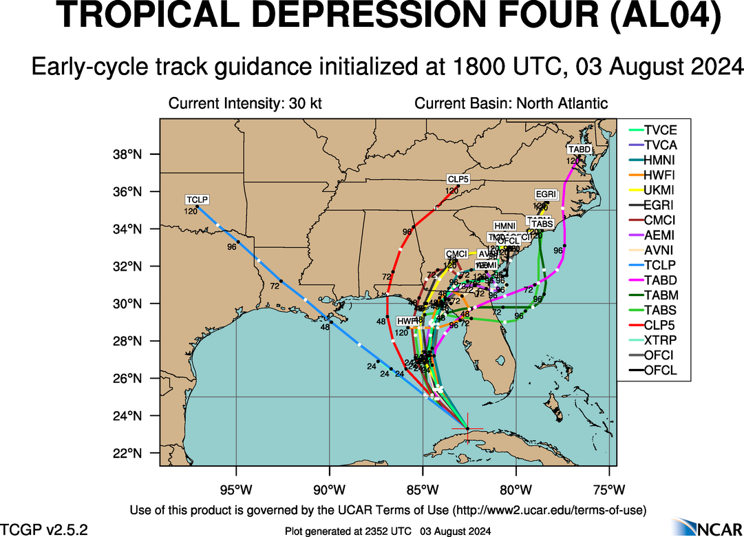
I did notice the mesoscale models (ie NAM) was backed off intensity from this morning with a slight shift west, with the center consolidating further west and later. They are not reliable for tropical storms, it is helpful to see how they are trending, especially with the global hurricane models struggling largely because of the current broadness of the low pressure. At least that my amateur opinion.

Eagerly waiting the GFS's hurricane model to finish running, but I think it will continue to struggle until we can get a well defined center.
0 likes   

User avatar
N2FSU
S2K Supporter
S2K Supporter
Posts: 1062
Joined: Thu Sep 04, 2003 2:04 pm
Location: Tallahassee, FL

Re: ATL: FOUR - Models

#222 Postby N2FSU » Sat Aug 03, 2024 12:04 pm

12z GFS Image
west shift and slightly stronger:
0 likes   

User avatar
ElectricStorm
Category 5
Category 5
Posts: 5017
Age: 24
Joined: Tue Aug 13, 2019 11:23 pm
Location: Skiatook, OK / Norman, OK

Re: ATL: FOUR - Models

#223 Postby ElectricStorm » Sat Aug 03, 2024 12:43 pm

12z Hurricane models weaker, with only the HWRF now showing a minimal hurricane. The rest have mid-strong TS. All four have it struggling for at least the next 24 hours before finally ramping up right before landfall. Seems pretty reasonable to me
1 likes   
I am in no way a professional. Take what I say with a grain of salt as I could be totally wrong. Please refer to the NHC, NWS, or SPC for official information.

Boomer Sooner!

User avatar
tronbunny
S2K Supporter
S2K Supporter
Posts: 1558
Joined: Wed Sep 01, 2004 1:18 am
Location: Central FL

Re: ATL: FOUR - Models

#224 Postby tronbunny » Sat Aug 03, 2024 12:45 pm

Thank goodness it's early, because this looks way overdone
N2FSU wrote:12z GFS https://uploads.tapatalk-cdn.com/20240803/0ea83bacf3f35bd767b2012d2a4fdd68.jpg
west shift and slightly stronger:
0 likes   

LarryWx
Category 5
Category 5
Posts: 6246
Joined: Sun Sep 07, 2003 2:04 pm
Location: GA

Re: ATL: FOUR - Models

#225 Postby LarryWx » Sat Aug 03, 2024 1:01 pm

12Z Euro has just about as bad a huge rainfall total for SAV-CHS as 0Z had (15”+) (slightly lower most of corridor but still with insane max ~22”centered on HHI/Beaufort). Also, again a cat 1 H hits CHS.
2 likes   
Personal Forecast Disclaimer:
The posts in this forum are NOT official forecasts and should not be used as such. They are just the opinion of the poster and may or may not be backed by sound meteorological data. They are NOT endorsed by any professional institution or storm2k.org. For official information, please refer to the NHC and NWS products.

Stratton23
Category 5
Category 5
Posts: 2370
Joined: Fri Jul 21, 2023 10:59 pm
Location: Katy, Tx

Re: ATL: FOUR - Models

#226 Postby Stratton23 » Sat Aug 03, 2024 2:25 pm

HWRF does a big loop and gets back into the gulf again after moving in land in georgia
1 likes   

User avatar
Steve
S2K Supporter
S2K Supporter
Posts: 9591
Joined: Sat Apr 05, 2003 11:41 pm
Location: Not a state-caster

Re: ATL: FOUR - Models

#227 Postby Steve » Sat Aug 03, 2024 3:06 pm

Most models hadn’t shown a loop back to the gulf since midweek more going with smaller loops or stalls in the sw Atlantic. I’m discounting a little but I’m sure it’s a function of HWrF at 500.


Early cycle 18z
https://hurricanes.ral.ucar.edu/realtim ... _early.png

Late eps 12z
https://hurricanes.ral.ucar.edu/realtim ... l_late.png
0 likes   

User avatar
Nimbus
Category 5
Category 5
Posts: 5274
Joined: Mon Jul 19, 2004 10:54 am

Re: ATL: FOUR - Models

#228 Postby Nimbus » Sat Aug 03, 2024 3:25 pm

Steve wrote:Most models hadn’t shown a loop back to the gulf since midweek more going with smaller loops or stalls in the sw Atlantic. I’m discounting a little but I’m sure it’s a function of HWrF at 500.


Early cycle 18z
https://hurricanes.ral.ucar.edu/realtim ... _early.png

Late eps 12z
https://hurricanes.ral.ucar.edu/realtim ... l_late.png


That was my question this morning... answered.
NHC statements warned they were not sure whether the track was going to stay over land or move back over water later in the forecast.
1 likes   

User avatar
Steve
S2K Supporter
S2K Supporter
Posts: 9591
Joined: Sat Apr 05, 2003 11:41 pm
Location: Not a state-caster

Re: ATL: FOUR - Models

#229 Postby Steve » Sat Aug 03, 2024 3:29 pm

NAMs 12km has 992 near landfall and the always aggressive 3km has it down to 983

None of the intensity modes (early cycle) take it past TS but Ship.
0 likes   

User avatar
Steve
S2K Supporter
S2K Supporter
Posts: 9591
Joined: Sat Apr 05, 2003 11:41 pm
Location: Not a state-caster

Re: ATL: FOUR - Models

#230 Postby Steve » Sat Aug 03, 2024 3:35 pm

Nimbus wrote:
Steve wrote:Most models hadn’t shown a loop back to the gulf since midweek more going with smaller loops or stalls in the sw Atlantic. I’m discounting a little but I’m sure it’s a function of HWrF at 500.


Early cycle 18z
https://hurricanes.ral.ucar.edu/realtim ... _early.png

Late eps 12z
https://hurricanes.ral.ucar.edu/realtim ... l_late.png


That was my question this morning... answered.
NHC statements warned they were not sure whether the track was going to stay over land or move back over water later in the forecast.


Right. Some of the morning models were trending a little more inland as it came up but obviously we’ll have to wait and see with tonight’s runs if they think Debby gets offshore. Possibly 3 landfalls are on the table but ?
0 likes   

User avatar
Nimbus
Category 5
Category 5
Posts: 5274
Joined: Mon Jul 19, 2004 10:54 am

Re: ATL: FOUR - Models

#231 Postby Nimbus » Sat Aug 03, 2024 3:43 pm

Steve wrote:NAMs 12km has 992 near landfall and the always aggressive 3km has it down to 983

None of the intensity modes (early cycle) take it past TS but Ship.


I expect to see surface pressure drops between passes when recon gets in there.
Maybe 1002 MB at the center now if the recent ships report was accurate.
Levi mentioned some dry shear yesterday, but that was assuming the trough picked Debby up before landfall..
2 likes   

User avatar
Emmett_Brown
Category 5
Category 5
Posts: 1432
Joined: Wed Aug 24, 2005 9:10 pm
Location: Sarasota FL

Re: ATL: DEBBY - Models

#232 Postby Emmett_Brown » Sat Aug 03, 2024 4:53 pm

18Z GFS is a little weaker, and a little W of the 12Z, landfalls in Apalachee Bay, so the W trend continues
0 likes   

User avatar
mitchell
Category 1
Category 1
Posts: 404
Joined: Wed Mar 19, 2003 8:22 am
Location: Delaware
Contact:

Re: ATL: DEBBY - Models

#233 Postby mitchell » Sat Aug 03, 2024 5:17 pm

What a crazy set of model outputs over the past 36 hours. Everything under the sun.
The 18z GFS has it on Thursday about 200 miles from where it started on Monday morning.
Image
0 likes   

User avatar
JtSmarts
S2K Supporter
S2K Supporter
Posts: 1436
Age: 39
Joined: Thu Jul 10, 2003 1:29 pm
Location: Columbia, South Carolina

Re: ATL: DEBBY - Models

#234 Postby JtSmarts » Sat Aug 03, 2024 5:36 pm

That GFS gives Debby about 36 hours over water between 1 and 2nd landfalls, thankfully GFS doesn't strengthen in rapidly during that time, but not a fan of her having that much Gulfstream time.
1 likes   

BobHarlem
Category 5
Category 5
Posts: 2034
Joined: Thu Oct 20, 2005 6:11 pm

Re: ATL: DEBBY - Models

#235 Postby BobHarlem » Sat Aug 03, 2024 8:35 pm

0z earlies with a right shift, both in Florida landfall and into Atlantic. (HWRF still the crazy uncle)
Image
0 likes   

User avatar
ElectricStorm
Category 5
Category 5
Posts: 5017
Age: 24
Joined: Tue Aug 13, 2019 11:23 pm
Location: Skiatook, OK / Norman, OK

Re: ATL: DEBBY - Models

#236 Postby ElectricStorm » Sat Aug 03, 2024 9:02 pm

18z HWRF, HAFS-A and HAFS-B have a minimal Cat 1 before landfall. HMON the weakest this cycle with a strong TS. Overall this cycle is pretty similar to the previous few cycles
1 likes   
I am in no way a professional. Take what I say with a grain of salt as I could be totally wrong. Please refer to the NHC, NWS, or SPC for official information.

Boomer Sooner!

User avatar
Steve
S2K Supporter
S2K Supporter
Posts: 9591
Joined: Sat Apr 05, 2003 11:41 pm
Location: Not a state-caster

Re: ATL: DEBBY - Models

#237 Postby Steve » Sat Aug 03, 2024 9:22 pm

ElectricStorm wrote:18z HWRF, HAFS-A and HAFS-B have a minimal Cat 1 before landfall. HMON the weakest this cycle with a strong TS. Overall this cycle is pretty similar to the previous few cycles


00z NAM 12km gets it to 984 vs 987 at 18z. 3km likes Wakulla County a hair west than I guessed. 3km gets to 960 which is a big stretch but expected for it. FV3 which is often decent to look at is squirreled this run. ICON up in a bit.
0 likes   

User avatar
chaser1
S2K Supporter
S2K Supporter
Posts: 5407
Age: 64
Joined: Sat Oct 15, 2005 5:59 pm
Location: Longwood, Fl

Re: ATL: DEBBY - Models

#238 Postby chaser1 » Sat Aug 03, 2024 10:17 pm

Yeah, I think I'll refrain from sending the 3K NAM to my Crawfordville friends right now lol. Well, far enough away from the coast to not worry about storm surge but that track would definately knock down a bunch of Pines and I'm sure the electricity too
1 likes   
Andy D

(For official information, please refer to the NHC and NWS products.)

User avatar
Steve
S2K Supporter
S2K Supporter
Posts: 9591
Joined: Sat Apr 05, 2003 11:41 pm
Location: Not a state-caster

Re: ATL: DEBBY - Models

#239 Postby Steve » Sat Aug 03, 2024 10:23 pm

0 likes   

Hurricane Mike
Category 2
Category 2
Posts: 644
Joined: Tue Apr 10, 2018 7:44 am

Re: ATL: DEBBY - Models

#240 Postby Hurricane Mike » Sat Aug 03, 2024 10:25 pm

Even if Debby moves offshore, the slow motion will still make this a rainmaking flood threat.
0 likes   


Return to “2024”

Who is online

Users browsing this forum: No registered users and 10 guests