Instead of forcefields and Indian burial grounds, could it just be that some areas of the coast are harder to hit due to general steering patterns, and that the cities built in these areas continued to flourish over time while the ones hit more consistently did not?
Remember, prior to 1900, Galveston was the big port city in Texas, not Houston.
ATL: DEBBY - Post-Tropical - Discussion
Moderator: S2k Moderators
-
cheezyWXguy

- Category 5

- Posts: 6282
- Joined: Mon Feb 13, 2006 12:29 am
- Location: Dallas, TX

Re: ATL: FOUR - Potential Tropical Cyclone - Discussion
At least the latest 18z track is closer to the vorticity I have been tracking since this morning, the reason why 18z models shifted west. I could see shifting even a little more west on tonight's model.
https://x.com/NDGMETCHEF/status/1819454768382988641
https://x.com/NDGMETCHEF/status/1819454768382988641
0 likes

Re: ATL: FOUR - Potential Tropical Cyclone - Discussion
NDG wrote:At least the latest 18z track is closer to the vorticity I have been tracking since this morning, the reason why 18z models shifted west. I could see shifting even a little more west on tonight's model.
https://x.com/NDGMETCHEF/status/1819454768382988641
That is where I saw the LLC center forming and recon isn't finding much north of Cuba.
The 12Z Euro track stayed west of Tampa probably as a stronger storm.
Where is the 18Z GFS first landfall?
0 likes

Re: ATL: FOUR - Potential Tropical Cyclone - Discussion
HurricaneBelle wrote:JaxGator wrote:wxman57 wrote:
Think Charley 2004 and Ian 2022. Tampa has a force field that makes storms move inland to the south of the forecast. Center may form beneath convection that is already north of the track. If so, then track will be adjusted farther down the coast.
The one exception would be Hurricane Idalia. It’s 2 against 1 but we’ll see. It does look like a center is consolidating south of Cuba/near the coast per the vorticity graphic from the University of Wisconsin. Don’t how to post a photo of it tho.
Idalia isn't the only exception - Hermine, Eta, Elsa, Debby 2012 and some others I'm likely forgetting all bypassed the Tampa Bay area moving north instead of turning in south of us. It's just that Charley and Ian were high-profile major hurricanes that were forecast to hit directly near here and ended up landfalling in SWFL. Charley was 20 years ago and modeling has come a long way since then, and Ian didn't exactly make a last-minute turn as the forecasts continually trended south and called it for it to make landfall south of Tampa Bay almost 48 hours before it did.
You’re right, apologies. And I experienced all of those tropical cyclones too. Except for Eta.
Last edited by JaxGator on Fri Aug 02, 2024 3:04 pm, edited 1 time in total.
1 likes
The posts or stuff said are NOT an official forecast. Please look to the NHC and NWS for official forecasts and products.
Floyd-1999, Frances-2004, Jeanne-2004, Fay-2008, Beryl-2012, Debby-2012, Colin-2016, Hermine-2016, Julia-2016, Matthew-2016, Irma-2017, Elsa-2021, Idalia-2023, Debby-2024, Helene-2024.
Go Gators! Go Jags!
Floyd-1999, Frances-2004, Jeanne-2004, Fay-2008, Beryl-2012, Debby-2012, Colin-2016, Hermine-2016, Julia-2016, Matthew-2016, Irma-2017, Elsa-2021, Idalia-2023, Debby-2024, Helene-2024.
Go Gators! Go Jags!

Re: ATL: FOUR - Potential Tropical Cyclone - Discussion
Nimbus wrote:NDG wrote:At least the latest 18z track is closer to the vorticity I have been tracking since this morning, the reason why 18z models shifted west. I could see shifting even a little more west on tonight's model.
https://x.com/NDGMETCHEF/status/1819454768382988641
That is where I saw the LLC center forming and recon isn't finding much north of Cuba.
The 12Z Euro track stayed west of Tampa probably as a stronger storm.
Where is the 18Z GFS first landfall?
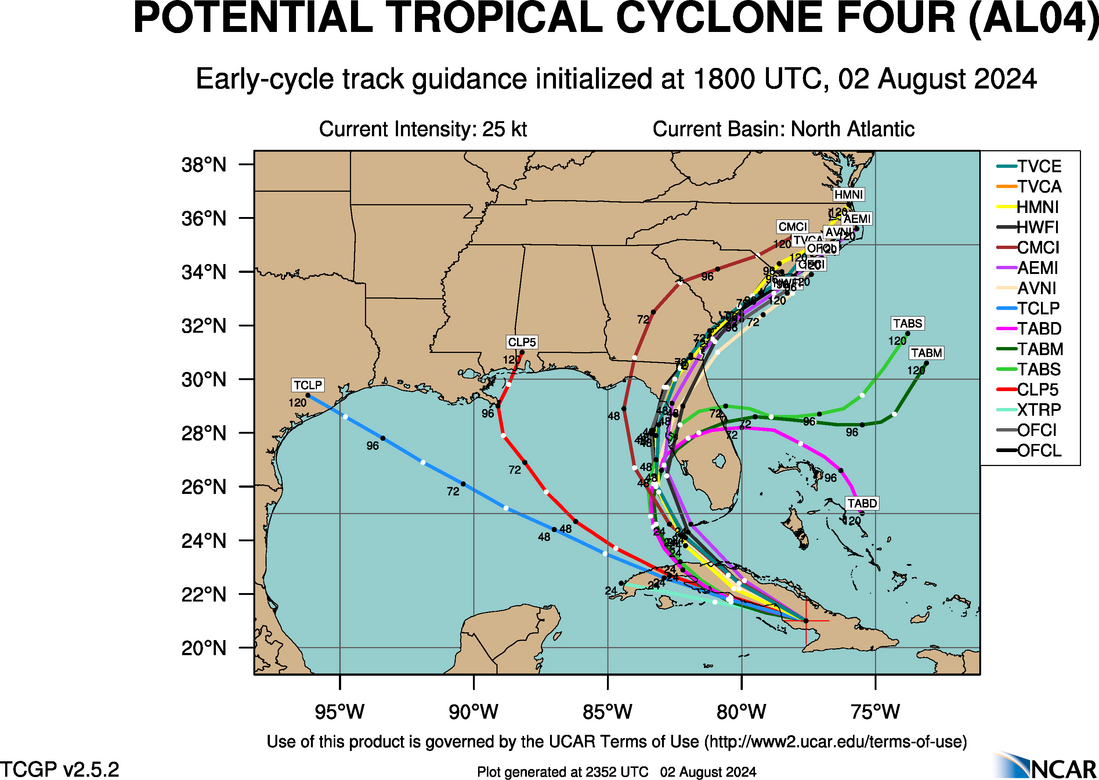
https://hurricanes.ral.ucar.edu/realtim ... _early.png
0 likes
-
Sciencerocks
- Category 5
- Posts: 10186
- Age: 40
- Joined: Thu Jul 06, 2017 1:51 am


Re: ATL: FOUR - Potential Tropical Cyclone - Discussion
Since Irma, with these close to florida/west coast Florida storms.I think i am going to stick with GFS over euro. I think we need to think about storm locations as well as the models when trying to pick which we believe more in. Curious of those in the gulf of Mexico which have been more right than wrong in the last 5-10 years?
1 likes
Re: ATL: FOUR - Potential Tropical Cyclone - Discussion
LandoWill wrote:Since Irma, with these close to florida/west coast Florida storms.I think i am going to stick with GFS over euro. I think we need to think about storm locations as well as the models when trying to pick which we believe more in. Curious of those in the gulf of Mexico which have been more right than wrong in the last 5-10 years?
The GFS and Euro have both had their fair share of wins over the years. It is best to pay attention to both considering they are the 2 best global models in the world. Generally the Euro is better for track but isn’t that useful for intensity (weak bias).
1 likes
-
tolakram
- Admin

- Posts: 20186
- Age: 62
- Joined: Sun Aug 27, 2006 8:23 pm
- Location: Florence, KY (name is Mark)
Re: ATL: FOUR - Potential Tropical Cyclone - Discussion
LandoWill wrote:Since Irma, with these close to florida/west coast Florida storms.I think i am going to stick with GFS over euro. I think we need to think about storm locations as well as the models when trying to pick which we believe more in. Curious of those in the gulf of Mexico which have been more right than wrong in the last 5-10 years?
Good question for the models thread, and also what to you mean by correct? If the GFS shows storms everywhere it will be right more often. There's an odd bias we have with models that tend to show a lot of phantoms vs those that don't.
0 likes
M a r k
- - - - -
Join us in chat: Storm2K Chatroom Invite. Android and IOS apps also available.
The posts in this forum are NOT official forecasts and should not be used as such. Posts are NOT endorsed by any professional institution or STORM2K.org. For official information and forecasts, please refer to NHC and NWS products.
Re: ATL: FOUR - Potential Tropical Cyclone - Discussion
LandoWill wrote:Since Irma, with these close to florida/west coast Florida storms.I think i am going to stick with GFS over euro. I think we need to think about storm locations as well as the models when trying to pick which we believe more in. Curious of those in the gulf of Mexico which have been more right than wrong in the last 5-10 years?
They are pretty similar (vs. operational EPS anyway)
18z Early Cycle GFS
https://hurricanes.ral.ucar.edu/realtim ... _early.png
12z late cycle EPS
https://hurricanes.ral.ucar.edu/realtim ... l_late.png
Last edited by Steve on Fri Aug 02, 2024 3:13 pm, edited 1 time in total.
0 likes


Re: ATL: FOUR - Potential Tropical Cyclone - Discussion
To my untrained eye Four is rapidly improving in appearance right now, markedly better than 6 hours ago. Still quite elongated, but major structural changes are happening in the southern quadrants. Large expansion of convection, weak west winds, and minor southerly banding. The convection to the North is also fanning itself around the developing southerly LCC.
Now the question is, will Four remain disorganized slop until the Gulf, or will the organizational trends continue and result in an early classification?
Now the question is, will Four remain disorganized slop until the Gulf, or will the organizational trends continue and result in an early classification?
2 likes
Re: ATL: FOUR - Potential Tropical Cyclone - Discussion
Steve wrote:Nimbus wrote:NDG wrote:At least the latest 18z track is closer to the vorticity I have been tracking since this morning, the reason why 18z models shifted west. I could see shifting even a little more west on tonight's model.
https://x.com/NDGMETCHEF/status/1819454768382988641
That is where I saw the LLC center forming and recon isn't finding much north of Cuba.
The 12Z Euro track stayed west of Tampa probably as a stronger storm.
Where is the 18Z GFS first landfall?
https://hurricanes.ral.ucar.edu/realtim ... _early.png
Latest EC ensembles have jumped on board with the developing vorticity south of Cuba thus a more western track, bulls eye on the Big Bend of FL. 48 hrs over the very warm waters of the GOM along with low wind shear, more than plenty of time for it to become at least a Cat 1 while in the gulf.
1 likes
Re: ATL: FOUR - Potential Tropical Cyclone - Discussion
Gfs on this one seems to have been more consistent. Sometimes they also should be taken on a case by case or storm by storm basis.
1 likes
-
HurricaneBelle

- S2K Supporter

- Posts: 1209
- Joined: Sun Aug 27, 2006 6:12 pm
- Location: Clearwater, FL
Re: ATL: FOUR - Potential Tropical Cyclone - Discussion
LandoWill wrote:Since Irma, with these close to florida/west coast Florida storms.I think i am going to stick with GFS over euro. I think we need to think about storm locations as well as the models when trying to pick which we believe more in. Curious of those in the gulf of Mexico which have been more right than wrong in the last 5-10 years?
Their history is only marginally relevant to the current situation - these models are tweaked on an annual basis and either way neither has had a lock on Gulf storms. Best bet as always is to go with the NHC track, however much we want something new more than 4 times a day as they're almost always more accurate than a single model.
1 likes
-
Hypercane_Kyle

- Category 5
- Posts: 3465
- Joined: Sat Mar 07, 2015 7:58 pm
- Location: Cape Canaveral, FL
Re: ATL: FOUR - Potential Tropical Cyclone - Discussion
LandoWill wrote:Since Irma, with these close to florida/west coast Florida storms.I think i am going to stick with GFS over euro. I think we need to think about storm locations as well as the models when trying to pick which we believe more in. Curious of those in the gulf of Mexico which have been more right than wrong in the last 5-10 years?
GFS and Euro are about the same to me as far as accuracy. Euro is generally poor at TC genesis and underdoes intensity, whereas the GFS has too many phantom storms and is often way out of whack for track.
2 likes
My posts are my own personal opinion, defer to the National Hurricane Center (NHC) and other NOAA products for decision making during hurricane season.
-
wxman57

- Moderator-Pro Met

- Posts: 23175
- Age: 68
- Joined: Sat Jun 21, 2003 8:06 pm
- Location: Houston, TX (southwest)
Re: ATL: FOUR - Potential Tropical Cyclone - Discussion
SFLcane wrote:wxman57 wrote:Lightning48 wrote:
What do you mean by a force field? Yes, Tampa hasn't been hit in over 100 years but due to people especially one as respected as you to say it is protected by a force field, I find that irresponsible and leads to complacency in the event a hurricane does come through Tampa Bay. I read your posts for many years and enjoy them
You're joking, right? Everyone here knows about the Tampa force field.
Not to sure NHC will be making any east shifts 18z models shift back west tampa might not be so lucky this go around thankfully this is not a major.
Yeah, center may form farther south. I nudged track west a bit, passing offshore Clearwater then inland in 48 hrs with 50-55 kt winds
4 likes
-
tolakram
- Admin
- Posts: 20186
- Age: 62
- Joined: Sun Aug 27, 2006 8:23 pm
- Location: Florence, KY (name is Mark)
Re: ATL: FOUR - Potential Tropical Cyclone - Discussion
saved loop

source: https://weather.cod.edu/satrad/?parms=meso-meso2-02-200-1-100-1&checked=map&colorbar=undefined
source: https://weather.cod.edu/satrad/?parms=meso-meso2-02-200-1-100-1&checked=map&colorbar=undefined
1 likes
M a r k
- - - - -
Join us in chat: Storm2K Chatroom Invite. Android and IOS apps also available.
The posts in this forum are NOT official forecasts and should not be used as such. Posts are NOT endorsed by any professional institution or STORM2K.org. For official information and forecasts, please refer to NHC and NWS products.
- - - - -
Join us in chat: Storm2K Chatroom Invite. Android and IOS apps also available.
The posts in this forum are NOT official forecasts and should not be used as such. Posts are NOT endorsed by any professional institution or STORM2K.org. For official information and forecasts, please refer to NHC and NWS products.
-
Frank P
- S2K Supporter
- Posts: 2779
- Joined: Fri Aug 29, 2003 10:52 am
- Location: Biloxi Beach, Ms
- Contact:
Re: ATL: FOUR - Potential Tropical Cyclone - Discussion
If PTC4 stays weak it just might go farther west than previous thought unless that trough ends up really digging down south
1 likes
-
weeniepatrol

- Category 5
- Posts: 1343
- Joined: Sat Aug 22, 2020 5:30 pm
- Location: WA State
Re: ATL: FOUR - Potential Tropical Cyclone - Discussion
Already has a robust poleward outflow channel, in association with an upper-level low located well to the NE

2 likes
-
StPeteMike

- Category 2

- Posts: 656
- Joined: Thu Jun 07, 2018 11:26 pm
Re: ATL: FOUR - Potential Tropical Cyclone - Discussion
Still broad, but hard to not say the center of circulation isn’t somewhere directly south of Jardines de la Reina there. Still moving more west than north currently.
0 likes
The above post is not official and should not be used as such. It is the opinion of the poster and may or may not be backed by sound meteorological data. It is not endorsed by any professional institution or storm2k.org. For official information, please refer to the NHC and NWS products.
Who is online
Users browsing this forum: No registered users and 2 guests