
ATL: MILTON - Models
Moderator: S2k Moderators
Re: ATL: MILTON - Models
18z HMON is Cedar Key, shift left for it from Crystal River, also 12 hours later landfall than the 12z. Like the HAFS models, it rapidly weakens before landfall.
Last edited by BobHarlem on Sat Oct 05, 2024 7:13 pm, edited 1 time in total.
1 likes

-
gatorcane

- S2K Supporter

- Posts: 23708
- Age: 48
- Joined: Sun Mar 13, 2005 3:54 pm
- Location: Boca Raton, FL
Re: ATL: MILTON - Models
chris_fit wrote:18z Euro looks weaker than 12z through 90 hours and a tad south.
Weaker = more south. That's probably why we see the hurricane models more north since they are very strong.
1 likes
-
TampaWxLurker
- Tropical Storm

- Posts: 196
- Joined: Thu Aug 01, 2024 8:20 am
Re: ATL: MILTON - Models
BobHarlem wrote:18z HMON is Cedar Key, shift left for it from Crystal River, also 12 hours later landfall than the 12z. Like the HAFS models, it rapidly weakens before landfall.
https://i.imgur.com/CRJ36m8.png
Landfall 18z Thursday is a lot later. Good gosh. Models are all over the place on this thing.
0 likes
-
Flwxguy86

- Tropical Depression

- Posts: 51
- Age: 39
- Joined: Sun Sep 15, 2024 11:06 am
- Location: Oldsmar,FL
Re: ATL: MILTON - Models
I put a little less weight into the the interim models like 06z and 18z, They always seem to be off compared to what I'd call the "main runs". I don't know if maybe there is less data in them or something but it seems that way to me.
3 likes
Re: ATL: MILTON - Models
18z HWRF late Wednesday night New Port Richey landfall, very bad for Bay surge here. Just a left shift from St. Pete, timing is the same as 12z.

2 likes

Re: ATL: MILTON - Models
HWRF, HMON, and HAFS-A all show Milton getting absolutely obliterated by shear as much as a full 24 hours prior to landfall. The contrast between a 160 kt/901 mbar Cat 5 Tuesday evening and a sheared mess barely 12 hours later on the HAFS-A is insane.
2 likes
Irene '11 Sandy '12 Hermine '16 5/15/2018 Derecho Fay '20 Isaias '20 Elsa '21 Henri '21 Ida '21
I am only a meteorology enthusiast who knows a decent amount about tropical cyclones. Look to the professional mets, the NHC, or your local weather office for the best information.
I am only a meteorology enthusiast who knows a decent amount about tropical cyclones. Look to the professional mets, the NHC, or your local weather office for the best information.
-
gatorcane
- S2K Supporter
- Posts: 23708
- Age: 48
- Joined: Sun Mar 13, 2005 3:54 pm
- Location: Boca Raton, FL
Re: ATL: MILTON - Models
chris_fit wrote:18z EPS.... Wow... R. I. P. Tampa Bay
I don't have access to the 18Z but the 12Z also look like RIP for Tampa Bay too:
0 likes

Re: ATL: MILTON - Models
Flwxguy86 wrote:I put a little less weight into the the interim models like 06z and 18z, They always seem to be off compared to what I'd call the "main runs". I don't know if maybe there is less data in them or something but it seems that way to me.
I thought someone said this year that 6z and 18z now have as much data as 0z and 12z, at least for global models, even though that wasn't the case before?
0 likes
TC naming lists: retirements and intensity
Most aggressive Advisory #1's in North Atlantic (cr. kevin for starting the list)
Most aggressive Advisory #1's in North Atlantic (cr. kevin for starting the list)
-
eastcoastFL

- Category 5

- Posts: 3996
- Age: 44
- Joined: Thu Apr 12, 2007 12:29 pm
- Location: Palm City, FL
Re: ATL: MILTON - Models
aspen wrote:HWRF, HMON, and HAFS-A all show Milton getting absolutely obliterated by shear as much as a full 24 hours prior to landfall. The contrast between a 160 kt/901 mbar Cat 5 Tuesday evening and a sheared mess barely 12 hours later on the HAFS-A is insane.
That “sheared mess” is still 942mb.
3 likes
Personal Forecast Disclaimer:
The posts in this forum are NOT official forecast and should not be used as such. They are just the opinion of the poster and may or may not be backed by sound meteorological data. They are NOT endorsed by any professional institution or storm2k.org. For official information, please refer to the NHC and NWS products.
The posts in this forum are NOT official forecast and should not be used as such. They are just the opinion of the poster and may or may not be backed by sound meteorological data. They are NOT endorsed by any professional institution or storm2k.org. For official information, please refer to the NHC and NWS products.
-
cycloneye

- Admin

- Posts: 149291
- Age: 69
- Joined: Thu Oct 10, 2002 10:54 am
- Location: San Juan, Puerto Rico
Re: ATL: MILTON - Models
00z intensity.

2 likes
Visit the Caribbean-Central America Weather Thread where you can find at first post web cams,radars
and observations from Caribbean basin members Click Here
and observations from Caribbean basin members Click Here
-
AutoPenalti
- Category 5
- Posts: 4091
- Age: 29
- Joined: Mon Aug 17, 2015 4:16 pm
- Location: Ft. Lauderdale, Florida
Re: ATL: MILTON - Models
tad left this run looks like
0 likes
The posts in this forum are NOT official forecasts and should not be used as such. They are just the opinion of the poster and may or may not be backed by sound meteorological data. They are NOT endorsed by any professional institution or STORM2K. For official information, please refer to products from the NHC and NWS.
Model Runs Cheat Sheet:
GFS (5:30 AM/PM, 11:30 AM/PM)
HWRF, GFDL, UKMET, NAVGEM (6:30-8:00 AM/PM, 12:30-2:00 AM/PM)
ECMWF (1:45 AM/PM)
TCVN is a weighted averaged
Re: ATL: MILTON - Models
eastcoastFL wrote:aspen wrote:HWRF, HMON, and HAFS-A all show Milton getting absolutely obliterated by shear as much as a full 24 hours prior to landfall. The contrast between a 160 kt/901 mbar Cat 5 Tuesday evening and a sheared mess barely 12 hours later on the HAFS-A is insane.
That “sheared mess” is still 942mb.
I doubt it’d have Cat 4 or even 3 sustained surface-level winds with a radar presentation like that, though. Almost looks like it’s beginning post-tropical transition.
1 likes
Irene '11 Sandy '12 Hermine '16 5/15/2018 Derecho Fay '20 Isaias '20 Elsa '21 Henri '21 Ida '21
I am only a meteorology enthusiast who knows a decent amount about tropical cyclones. Look to the professional mets, the NHC, or your local weather office for the best information.
I am only a meteorology enthusiast who knows a decent amount about tropical cyclones. Look to the professional mets, the NHC, or your local weather office for the best information.
-
Hypercane_Kyle

- Category 5
- Posts: 3465
- Joined: Sat Mar 07, 2015 7:58 pm
- Location: Cape Canaveral, FL
Re: ATL: MILTON - Models
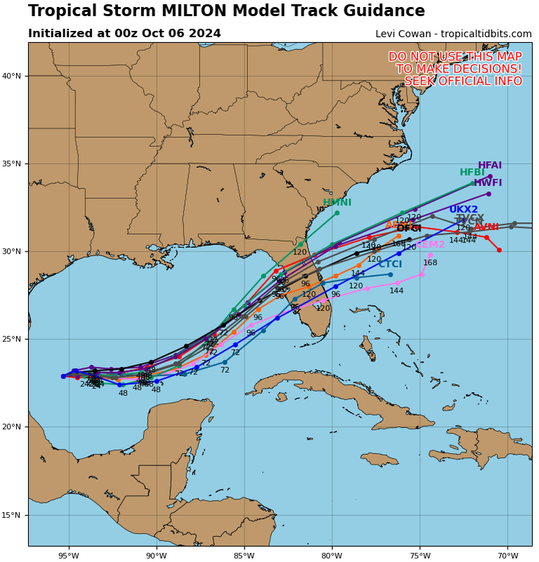
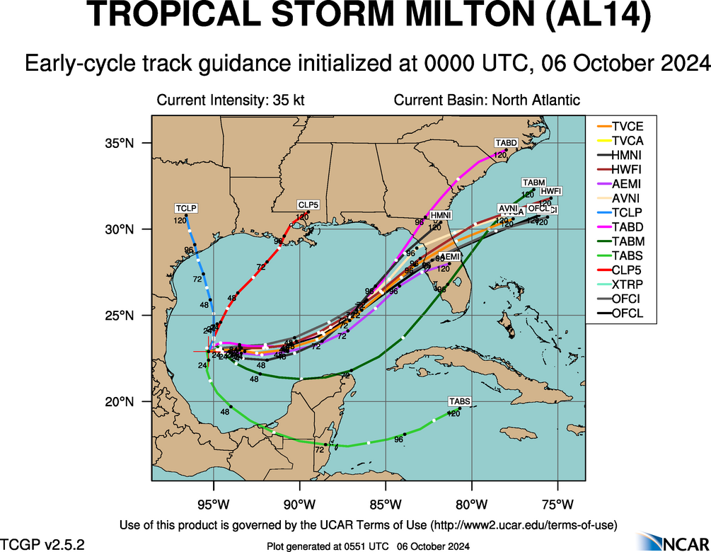
00z TVCN has not budged. I do not expect any shift north at 11pm.
0 likes
My posts are my own personal opinion, defer to the National Hurricane Center (NHC) and other NOAA products for decision making during hurricane season.

Re: ATL: MILTON - Models
Early cycle 00z’s out agreeing with Gatorcanes graphic. Not that it’s going to be some Armageddon stuff but Lakeland, Ocala, Gainesville, etc. y’all already know.
https://hurricanes.ral.ucar.edu/realtim ... _early.png
https://hurricanes.ral.ucar.edu/realtim ... _early.png
Last edited by Steve on Sat Oct 05, 2024 8:02 pm, edited 1 time in total.
1 likes
Re: ATL: MILTON - Models
The HWRF really highlights the broadening of Milton's windfield as it nears the coast. Even if the storm is weaking, the storm's size would be expanding which would heighten the storm surge risk.
https://imgur.com/gallery/8Q3hgTm
https://imgur.com/gallery/8Q3hgTm
0 likes
-
eastcoastFL
- Category 5
- Posts: 3996
- Age: 44
- Joined: Thu Apr 12, 2007 12:29 pm
- Location: Palm City, FL
Re: ATL: MILTON - Models
gatorcane wrote:00Z guidance:
https://i.postimg.cc/Z5yGJpZP/14-L-tracks-00z.png
The timing on that little SW dip that some models show could be interesting. If that plays out as it’s crossing the state it could put some unsuspecting areas under the gun.
1 likes
Personal Forecast Disclaimer:
The posts in this forum are NOT official forecast and should not be used as such. They are just the opinion of the poster and may or may not be backed by sound meteorological data. They are NOT endorsed by any professional institution or storm2k.org. For official information, please refer to the NHC and NWS products.
The posts in this forum are NOT official forecast and should not be used as such. They are just the opinion of the poster and may or may not be backed by sound meteorological data. They are NOT endorsed by any professional institution or storm2k.org. For official information, please refer to the NHC and NWS products.
Who is online
Users browsing this forum: No registered users and 7 guests