ATL: MILTON - Post-Tropical - Discussion
Moderator: S2k Moderators
-
PDKlikatino
- Tropical Low

- Posts: 20
- Age: 19
- Joined: Tue Aug 13, 2024 5:16 pm
- Location: Tampa, FL
Re: ATL: MILTON - Hurricane - Discussion
I'm hoping that the EWRC will have knocked Milton down a peg or two and he won't have a chance to recover before the shear hits tomorrow. Will the wider eye help keep Milton from regaining as much intensity as he had earlier? If that's the case, then we might be in a better situation in terms of surge.
1 likes
My posts are not official forecasts, just guesses. For accurate information, visit the NHC or NWS websites instead.
-
Flwxguy86

- Tropical Depression

- Posts: 51
- Age: 39
- Joined: Sun Sep 15, 2024 11:06 am
- Location: Oldsmar,FL
Re: ATL: MILTON - Hurricane - Discussion
2am Advisory has the winds down to a still blistering but lower 155 and the pressure up to 924mb. Could be EWRC or something else. Doesn't look as great as earlier either but maybe it will bounce back in 24 hours.
0 likes
Re: ATL: MILTON - Hurricane - Discussion
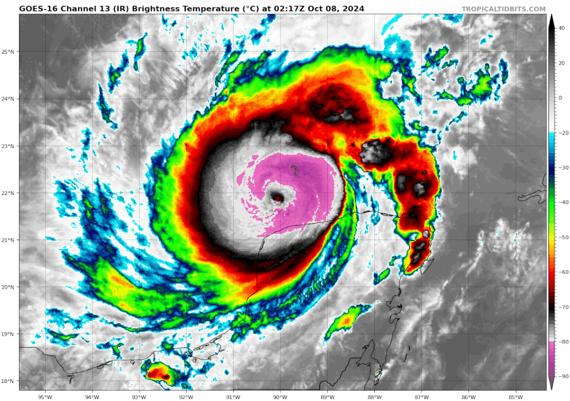
Beef Stew wrote:Stormgodess wrote:Teban54 wrote:Even during EWRC, Milton still wants to keep the -80C ring.
https://i.postimg.cc/nzZqPcJr/goes16-ir-14-L-202410080217.gif
Geez Scorpion reef is getting pounded right now. I realize it's uninhabited, but wonder what sort of ecological damage a storm like this could do to it?
Hey! This is a topic I’ve actually participated in research on, so I can provide a bit of insight:
In summary, truly pristine and unaltered ecosystems in the tropics tend to handle hurricane/cyclone impacts well. After all, they’ve coexisted with the most intense storms on earth for millions of years- ecosystems adapt to their environment, and frequent (on a geological time scale) intense hurricanes are one of the factors that life in the tropics has evolved to handle, and in many cases, even depend on to survive in a variety of ways (I could go more into detail here, but there are many ways the disruption of a cyclone allows for new life to flourish; similar to a forest fire clearing underbrush and allowing new growth to sprout).
Now, the huge caveat here is that very few ecosystems are truly pristine and not under duress from anthropogenic factors in modern times. While ecosystems have evolved to handle hurricanes, they haven’t evolved to handle human pollution that gets washed into them, redirected surge and run off, storm fatalities on species that are already endangered from other causes, etc.
The biggest impact in this regard for marine environments like scorpion reef is that corals throughout the Caribbean (and tropics worldwide, for that matter) are already under immense threat from both infectious disease and coral bleaching, both of which are rising in occurrence due to increased thermal stress linked to anthropogenic warming. Reefs in the Caribbean have been decimated by both disease and bleaching in recent decades- unfortunately, while they would weather storms if they were healthy, it is much, much more difficult when they’re already struggling from dramatic and unprecedented environmental changes.
I could go into much more depth with this answer, but I don’t want to get too off topic. Long-answer-short: pristine and wild places like scorpion reef can handle the impacts of hurricanes better than nearly any ecosystem on the planet, yet will still be susceptible to potentially significant ecological damage due to enhanced vulnerability from the downstream effects of anthropogenic influence that reaches even the most remote of locations.
My uncle has lived on St. Thomas for 25 years. Not quite as pristine but still a neat family hack, we’ve gone most of my life. He was there for Irma when it went through and totally decimated the islands down there. They looked nuke - trees all naked. You could see the physical toll on the nature for about 3-4 years. We went the following summer and it was still unbelievable to see the trees and devastation. Now, you can barely tell it went through there physically. Obviously there are still some signs on the man made toll but for the most part, you wouldn’t be able to tell that island was bombed not that long ago. Pretty crazy. Fun fact - he had to ride that storm out boarded up with a 3 day old newborn. They had to cut their way out of their house for about half a mile and they didn’t have power for like 3 months.
I’m a major amateur and I’ve been lurking and learning here for years so forgive me, but do Hurricanes make landfall at their specific strength strictly based on the timing of the EWRC and whether it’s peaking or rebuilding?
Last edited by Haddox12 on Tue Oct 08, 2024 1:18 am, edited 2 times in total.
4 likes
Re: ATL: MILTON - Hurricane - Discussion: 180 mph / 897 mbs
gailwarning wrote:canetoad wrote:norva13x wrote:FEMA has a colossal task already from multiple major storms including as recently as a couple weeks ago! If anything I want to thank them and local officials for doing all they can, the scope is unimaginable right now.
I agree - to the earlier posts about FEMA not being around to clear the debris especially and the governor having to intervene and cut locks at the dump sites... in my understanding, FEMA is only ever meant to step in when the state is overwhelmed and can't handle the recovery on its own, so I don't really get the narrative that the state handling its own affairs means the feds have failed or are underperformoing. In theory, a governor setting things in motion should just be a sign of good emergency management and appropriate state budgeting, not needing as much assistance from the federal government.
I would also like to point out that "FEMA" itself is just a coordinating body, mostly. They manage the purse strings but Congrrss routinely has to replenish the oft-depleted disaster relief funds in recent years.
Most of the folks that roll in are perhaps sent by FEMA as head coordinator and funds distrubutor but it's largely a mix of deployment-ready military, first responders / swift water rescue teams, power restoration company employees, nonprofit volunteers like Salvation Army, Samaritan's Purse and the Scientologists, and locally hired contractors, with some FEMA reservists mixed in mistly to go door to door signing folks up for relief programs. The assembled apparatus is almost always an impressively massive mix of folks from all walks of life and careers, and my hat's off to all of them.
The problem in 2017 was that a lot of those folks couldn't even get out to Puerto Rico and were stretched mighty thin between Houston, Florida, the Caribbean, and the California wildfires, and I fear we might be approaching that now as well if Milton causes even half as much damage as still remains from Helene. The helpers are always there, but they're not an infinite resource and this one-two punch much be causing significant strain on the community of volunteers and professionals alike
Not to mention the 1,200 or so FEMA reps that are fully occupied in WNC. If FEMA is stretched too thin, it's Congress we need to have a word with.
Please stop with political posts. This isnt just about budgeting. Fema is also its own worst enemy with massive red tape, rules and protocols which severly inhibit local officials and civilians wanting to help but this isn't the place for that conversation.
8 likes
-
otowntiger
- Category 5

- Posts: 1932
- Joined: Tue Aug 31, 2004 7:06 pm
Re: ATL: MILTON - Hurricane - Discussion
Looks like the satellite presentation after the ERC is much improved. Anybody agree?
4 likes

Re: ATL: MILTON - Hurricane - Discussion
Haddox12 wrote:Beef Stew wrote:Stormgodess wrote:
Geez Scorpion reef is getting pounded right now. I realize it's uninhabited, but wonder what sort of ecological damage a storm like this could do to it?
Hey! This is a topic I’ve actually participated in research on, so I can provide a bit of insight:
In summary, truly pristine and unaltered ecosystems in the tropics tend to handle hurricane/cyclone impacts well. After all, they’ve coexisted with the most intense storms on earth for millions of years- ecosystems adapt to their environment, and frequent (on a geological time scale) intense hurricanes are one of the factors that life in the tropics has evolved to handle, and in many cases, even depend on to survive in a variety of ways (I could go more into detail here, but there are many ways the disruption of a cyclone allows for new life to flourish; similar to a forest fire clearing underbrush and allowing new growth to sprout).
Now, the huge caveat here is that very few ecosystems are truly pristine and not under duress from anthropogenic factors in modern times. While ecosystems have evolved to handle hurricanes, they haven’t evolved to handle human pollution that gets washed into them, redirected surge and run off, storm fatalities on species that are already endangered from other causes, etc.
The biggest impact in this regard for marine environments like scorpion reef is that corals throughout the Caribbean (and tropics worldwide, for that matter) are already under immense threat from both infectious disease and coral bleaching, both of which are rising in occurrence due to increased thermal stress linked to anthropogenic warming. Reefs in the Caribbean have been decimated by both disease and bleaching in recent decades- unfortunately, while they would weather storms if they were healthy, it is much, much more difficult when they’re already struggling from dramatic and unprecedented environmental changes.
I could go into much more depth with this answer, but I don’t want to get too off topic. Long-answer-short: pristine and wild places like scorpion reef can handle the impacts of hurricanes better than nearly any ecosystem on the planet, yet will still be susceptible to potentially significant ecological damage due to enhanced vulnerability from the downstream effects of anthropogenic influence that reaches even the most remote of locations.
My uncle has lived on St. Thomas for 25 years. Not quite as pristine but still a neat family hack, we’ve gone most of my life. He was there for Irma when it went through and totally decimated the islands down there. They looked nuke - trees all naked. You could see the physical toll on the nature for about 3-4 years. We went the following summer and it was still unbelievable to see the trees and devastation. Now, you can barely tell it went through there physically. Obviously there are still some signs on the man made toll but for the most part, you wouldn’t be able to tell that island was bombed not that long ago. Pretty crazy. Fun fact - he had to ride that storm out boarded up with a 3 day old newborn. They had to cut their way out of their house for about half a mile and they didn’t have power for like 3 months.
I’m a major amateur and I’ve been lurking and learning here for years so forgive me, but do Hurricanes make landfall at their specific strength strictly based on the timing of the EWRC and whether it’s peaking or rebuilding?
You have gotten a great start understanding the great question with hurricane tracking. It's all about understanding/forecasting where the storm will be in its development/decline cycle at landfall in order to extrapolate impacts. To say it's a tricky business would be an understatement. When it comes to second order impacts like storm surge that have built in delays in their development and decline, the forecast becomes even more difficult. Those of us here watching for decades continue to learn from each season and storm. We've come a long way; but we have further to go.
4 likes
Personal Forecast Disclaimer:
The posts in this forum are NOT official forecast and should not be used as such. They are just the opinion of the poster and may or may not be backed by sound meteorological data. They are NOT endorsed by any professional institution or storm2k.org. For official information, please refer to the NHC and NWS products.
The posts in this forum are NOT official forecast and should not be used as such. They are just the opinion of the poster and may or may not be backed by sound meteorological data. They are NOT endorsed by any professional institution or storm2k.org. For official information, please refer to the NHC and NWS products.
-
CFLHurricane

- Category 1

- Posts: 349
- Joined: Thu Mar 27, 2014 5:56 pm
- Location: Floriduh
Re: ATL: MILTON - Hurricane - Discussion
otowntiger wrote:Looks like the satellite presentation after the ERC is much improved. Anybody agree?
The IR band lighting up with renewed hot pink vigor around the eye tells me Milton’s greatest hits are yet to come.
1 likes
I'm not a meteorologist, but I did stay at a motel 8.

Re: ATL: MILTON - Hurricane - Discussion
Absurd presentation once again. Once the eye starts clearing out again it's once again off to the races.

6 likes
-
Keldeo1997
- Category 2

- Posts: 688
- Joined: Fri Oct 11, 2019 11:35 pm


Re: ATL: MILTON - Hurricane - Discussion
otowntiger wrote:Looks like the satellite presentation after the ERC is much improved. Anybody agree?
If you had asked me an hour ago I would have disagreed, but I think you are right. Looks like the cold -80 (pink) tops are making an effort to wrap around the center again. At the same time though, the over all appearance looks a little bit "off". Thus far all I've seen is pretty much a eastward motion however there clearly appears to be signs that a more NE motion might be finally in play. Which would make sense because otherwise Milton would have no shot at meeting the NHC 36 hr forecast point from 12Z this morning (to reach 22.9 & 87.5 at 18Z Tue. pm). Impressively, check out the 24 hr forecast for the 0600 forecast point (now), from early this morning:
24H 08/0600Z 21.8N 89.3W 135 KT 155 MPH. They not only pretty much nailed the fix, but also the wind speed.
2 likes
Andy D
(For official information, please refer to the NHC and NWS products.)
(For official information, please refer to the NHC and NWS products.)
Re: ATL: MILTON - Hurricane - Discussion
Welp, that's pretty organized after a quick ERC. I'd expect that to quickly clear out the remnants of the old inner eyewall and be off to the races by morning. I was hoping for a longer cycle that would leave it more disorganized. I hope I'm completely wrong.
2 likes
Personal Forecast Disclaimer:
The posts in this forum are NOT official forecast and should not be used as such. They are just the opinion of the poster and may or may not be backed by sound meteorological data. They are NOT endorsed by any professional institution or storm2k.org. For official information, please refer to the NHC and NWS products.
The posts in this forum are NOT official forecast and should not be used as such. They are just the opinion of the poster and may or may not be backed by sound meteorological data. They are NOT endorsed by any professional institution or storm2k.org. For official information, please refer to the NHC and NWS products.
-
Rail Dawg
- S2K Supporter

- Posts: 326
- Joined: Mon Aug 27, 2012 5:02 pm
- Location: Where the eye makes landfall.
Re: ATL: MILTON - Hurricane - Discussion
From the latest NHC advisory:
"While fluctuations in intensity are expected, Milton is forecast to remain an extremely
dangerous hurricane through landfall in Florida."
That is met-speak for we know where this thing is pointed but we really have no idea how bad it's going to get.
Chuck
"While fluctuations in intensity are expected, Milton is forecast to remain an extremely
dangerous hurricane through landfall in Florida."
That is met-speak for we know where this thing is pointed but we really have no idea how bad it's going to get.
Chuck
9 likes
Although I have been a hurricane forecaster since 1980 that only means I've been wrong lots of times.

Re: ATL: MILTON - Hurricane - Discussion
Milton's first peak was indeed most likely a little lower than what recon found. However, when recon arrived Milton still had perfect imagery. So the EWRC was just barely starting at that point. It may have been a little stronger earlier, but I think it most likely peaked in the 890 - 895 mb range instead of the 880s. Either way, a historic hurricane. And now Milton's just flexing by only weakening to 135 kt during its EWRC. The new eyewall looks extremely violent. Getting back into the 800s might be difficult (though not impossible), but I wouldn't be surprised if this second peak has similar if not stronger wind speeds.
5 likes

Re: ATL: MILTON - Hurricane - Discussion
Also an interesting fun fact: Milton's CDO was by far the coldest ever observed in the GOM with -81.07C and almost as cold as Wilma's CDO of -81.58C.
8 likes
-
Rail Dawg
- S2K Supporter
- Posts: 326
- Joined: Mon Aug 27, 2012 5:02 pm
- Location: Where the eye makes landfall.
Re: ATL: MILTON - Hurricane - Discussion
A suggestion is to study the fuel for this hurricane.
It isn't going to be a hurricane without lots and lots of latent heat coming from the Gulf.
Now take a look at a worldwide sea surface temperature chart for today and you will see the hottest ocean water on earth is currently in the Gulf.
Lots of good hot fuel ahead of Milton just waiting for a little lift up.
It's called weather-guessing for a reason sometimes.
Chuck
1 likes
Although I have been a hurricane forecaster since 1980 that only means I've been wrong lots of times.
-
Keldeo1997
- Category 2
- Posts: 688
- Joined: Fri Oct 11, 2019 11:35 pm
Re: ATL: MILTON - Hurricane - Discussion
Landy wrote:Incredible low-level MW pass...!!
https://media.discordapp.net/attachments/733552978572869632/1293102925630935130/20241008_061132_AL142024_gmi_GPM_color37_124kts_100p00_res1p0-cr100-akima-bgInfrared-Gray.png?ex=67062772&is=6704d5f2&hm=79d54fe5d8e095795b1cc31362c3f609dc24aeb3ecde290ad1c778c3681aa6a4&=&format=webp&quality=lossless&width=689&height=666
Like What GCANE would say, the Deadly pink Donut. Irma had this same signature as she was exploding.
Last edited by Keldeo1997 on Tue Oct 08, 2024 2:10 am, edited 1 time in total.
0 likes
Re: ATL: MILTON - Hurricane - Discussion
Category5Kaiju wrote:ConvergenceZone wrote:wow, this thread really slowed down
I mean...it is past midnight for many on the East Coast, and between how this really ramped up during the day, I think a bit of "tracker's exhaustion" may be setting in. I'm going to bed....we'll see what this beast looks like tomorrow morning.
OMG, that is a fact. I'm just exhausted. Between being glued to this discussion thread and last minute errands to catch up on some home preps, and communicating with friends and family spread out between Miami, Jensen Beach, Ft. Pierce, Orlando, and Jax wanting to get a storm update i'm beat. Of course, I had to drag myself out of bed to take a brief look LOL. In fact, I only late this evening have found time and bothered to look at the various model data while attempting to make sense of the NHC forecast track and timing. I'm starting to think (and agree with a few other posters here), that I'm just not seeing the impetus for the storm to gain quite as much latitude as forecast. Bottom line is I'm beginning to think that Milton will make landfall further south between Sarasota and Ft. Myers. This has a number of ramifications beyond who will simply get the worse storm surge and inland winds. There may be a lttle less intensity degradation as a result of being slightly further south. That would be great news for peeps in Tampa and across the I-4 including Orlando. Not so great news for those from Port St. Lucie to Melbourne (and especially those further south on the W Coast). Or...... I'm brain-dead tired and better re-assess in the a.m.
1 likes
Andy D
(For official information, please refer to the NHC and NWS products.)
(For official information, please refer to the NHC and NWS products.)

Re: ATL: MILTON - Hurricane - Discussion
Possibly a dumb question, but what does this mean in the 10/7 10pm CDT advisory? “As noted earlier, the track is closer to the model predicted fields rather than the model trackers which appear to be too far south.”
Googling for various combinations of +hurricane +“predicted fields” just turns up this advisory itself…
Googling for various combinations of +hurricane +“predicted fields” just turns up this advisory itself…
1 likes

Re: ATL: MILTON - Hurricane - Discussion
PDKlikatino wrote:I'm hoping that the EWRC will have knocked Milton down a peg or two and he won't have a chance to recover before the shear hits tomorrow. Will the wider eye help keep Milton from regaining as much intensity as he had earlier? If that's the case, then we might be in a better situation in terms of surge.
Not if the wind field expands. While the eyewall would likely see bigger surge in a small area with the pin hole eye it had earlier, a larger eye with a larger wind field would result in significant surge much further from the center.
2 likes
Who is online
Users browsing this forum: No registered users and 13 guests