
ATL: MILTON - Post-Tropical - Discussion
Moderator: S2k Moderators
-
tolakram
- Admin

- Posts: 20173
- Age: 62
- Joined: Sun Aug 27, 2006 8:23 pm
- Location: Florence, KY (name is Mark)
Re: ATL: MILTON - Hurricane - Discussion: 145 mph / 929 mbs
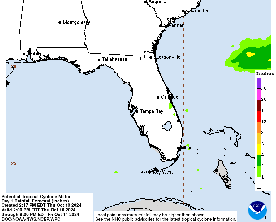
Here's the GFS total rainfall prediction as of the last run.
5 likes
M a r k
- - - - -
Join us in chat: Storm2K Chatroom Invite. Android and IOS apps also available.
The posts in this forum are NOT official forecasts and should not be used as such. Posts are NOT endorsed by any professional institution or STORM2K.org. For official information and forecasts, please refer to NHC and NWS products.
Re: ATL: MILTON - Hurricane - Discussion: 145 mph / 929 mbs
Steve wrote:Clearcloudz wrote:This question has been on my mind for some time so I'm going to go ahead and ask in this forum. Most professionals say to evacuate storm surge which is very important and I completely understand that but why do professionals also not focus on freshwater flooding that could occur from this storm. Some models are showing 24 inches of rain in a very short amount of time and I believe people will be caught off guard by the freshwater flooding from this storm. A suggestion could be just like the NHC used potential storm surge maps maybe the NWS can use potential fresh water flooding maps. From recent storms like Helene a lot people who were asked said that if they knew it would flood like this they would evacuate.
I think that's more on the NOAA/NWS forecast offices. NHC always has a summary of hazards the number at the end of their discussions. They also will emphasize if there is a specific rain threat for a system. And they have a graphic they use for rainfall. For instance:
Rainfall Graphic on the storm section of the home page.
https://www.nhc.noaa.gov/storm_graphics/AT14/refresh/AL1424WPCQPF+gif/092140WPCQPF_sm.gif
From the discussion;
Key Messages:
1. Damaging hurricane-force winds and a life-threatening storm surge
with destructive waves are expected across portions of the northern
coast of the Yucatan Peninsula today.
2. Milton is expected to grow in size and remain an extremely
dangerous hurricane when it approaches the west coast of Florida on
Wednesday. A large area of destructive storm surge will occur along
parts of the west coast of Florida. This is an extremely
life-threatening situation and residents in those areas should
follow advice given by local officials and evacuate immediately if
told to do so.
3. Devastating hurricane-force winds are expected along portions of
the west coast of Florida, where a Hurricane Warning is in effect.
Milton is forecast to remain a hurricane as it crosses the Florida
Peninsula and life-threatening hurricane-force winds, especially in
gusts, are expected to spread inland across the peninsula.
Preparations to protect life and property in the warning areas
should be complete by tonight.
4. Areas of heavy rainfall will continue to impact portions of
Florida well ahead of Milton through early Thursday. This rainfall
brings the risk of life-threatening flash, urban and aerial
flooding along with moderate to major river flooding. Flooding will
be exacerbated in areas where coastal and inland flooding combine to
increase the overall threat.
Everyday people don't look at that with everything going on during a hurricane. The flooding message in the past has gotten lost or not believed by people/professionals unfortunately. Harvey comes to mind in SE Texas. Now, should people educate themselves absolutely! I got lucky for Harvey and had a heads up from another forum and my gut said it can't hurt to prepare. I pay close attention to every storm now.
5 likes

Re: ATL: MILTON - Hurricane - Discussion: 145 mph / 929 mbs
tolakram wrote:Here's the GFS total rainfall prediction as of the last run.
https://i.imgur.com/vl6S0WB.png
Will be interesting to see how this hits the theme parks.
0 likes
// Opinions are my own, I am not a Meteorologist. Consult the NHC or Local NWS and Emergency Management for current information in your area. //
-
bob rulz
- Category 5

- Posts: 1711
- Age: 35
- Joined: Sat Jan 28, 2006 7:30 pm
- Location: Salt Lake City, Utah
Re: ATL: MILTON - Hurricane - Discussion: 145 mph / 929 mbs
SecondBreakfast wrote:Clearcloudz wrote:This question has been on my mind for some time so I'm going to go ahead and ask in this forum. Most professionals say to evacuate storm surge which is very important and I completely understand that but why do professionals also not focus on freshwater flooding that could occur from this storm. Some models are showing 24 inches of rain in a very short amount of time and I believe people will be caught off guard by the freshwater flooding from this storm. A suggestion could be just like the NHC used potential storm surge maps maybe the NWS can use potential fresh water flooding maps. From recent storms like Helene a lot people who were asked said that if they knew it would flood like this they would evacuate.
Inland flooding from Helene was well forecast, including news outlets saying it would rival the 1916 flood in the Appalachians. I also have seen warnings up for Milton for inland low lying areas, including graphics showing the extreme flash flooding risk in and around Orlando. I am sure my brother is about to live on a small island because of all the ponds in his subdivision.
The fact that there are people who said “if I’d only known” is an important indicator that the messaging isn’t getting to a lot of people who need it, and that should be a top policy priority to sort out.
I wonder if we're seeing the downsides of so many people getting their news from social media. Nobody really gets the daily newspaper anymore (if there even is a daily newspaper anymore) and most people (especially young people) don't watch local news anymore. There's more information available at your fingertips than ever before, but that doesn't mean people are getting the information that they need. Especially since people who live in Appalachia are not going to regularly be checking on the status of hurricanes like people in Florida might be.
Of course I'm just speculating. I live far away from hurricane danger zones and just follow them out of interest. But this is what I see happening in general when it comes to the news.
Back to Milton - he is looking a little bit ragged (relatively speaking of course) at the moment. But I think once he pulls away from the cooler water patch and the Yucatan Peninsula, it's off to the races.
6 likes

Re: ATL: MILTON - Hurricane - Discussion: 145 mph / 929 mbs
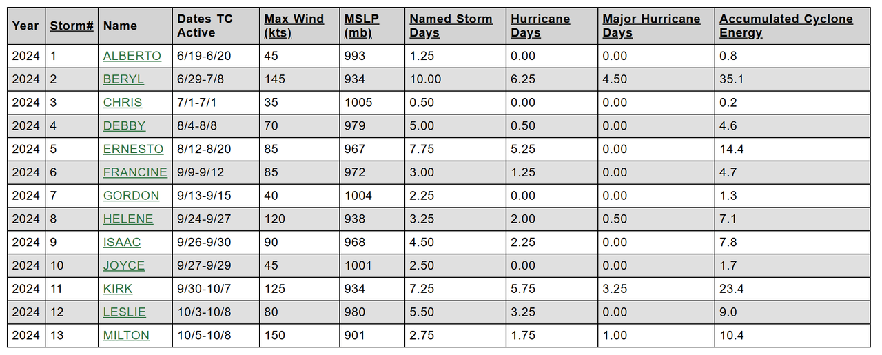
Milton has already generated 10.4 ACE, more than Helene, Isaac and Leslie did in each of their lifetimes, and on track to surpassing Ernesto. Its intensity definitely contributed to that.
8 likes
TC naming lists: retirements and intensity
Most aggressive Advisory #1's in North Atlantic (cr. kevin for starting the list)
Most aggressive Advisory #1's in North Atlantic (cr. kevin for starting the list)
-
ScottNAtlanta

- Category 5
- Posts: 2535
- Joined: Sat May 25, 2013 3:11 pm
- Location: Atlanta, GA
Re: ATL: MILTON - Hurricane - Discussion: 145 mph / 929 mbs
https://x.com/webberweather/status/1843641808884293965
https://x.com/webberweather/status/1843642477343060287
https://x.com/webberweather/status/1843642477343060287
1 likes
The posts in this forum are NOT official forecast and should not be used as such. They are just the opinion of the poster and may or may not be backed by sound meteorological data. They are NOT endorsed by any professional institution or storm2k.org. For official information, please refer to the NHC and NWS products.

Re: ATL: MILTON - Hurricane - Discussion: 145 mph / 929 mbs
JayTX wrote:Everyday people don't look at that with everything going on during a hurricane. The flooding message in the past has gotten lost or not believed by people/professionals unfortunately. Harvey comes to mind in SE Texas. Now, should people educate themselves absolutely! I got lucky for Harvey and had a heads up from another forum and my gut said it can't hurt to prepare. I pay close attention to every storm now.
You are right, but the information is literally on the home page of the NHC. Everyone uses smart phones and computers, so NHC does what it can. You and I are able to use the information to our advantage and get the heads up because we are enthusiasts and know when we need to take action. There was a time in the past where it was mandated that local weather people use nothing but NHC information. I can't remember if it was the 70's or 80's when that began to change. I guess with corporatization or whatever, some tv mets started going a little rogue. We always had trustworthy weather persons in New Orleans, so it wasn't really that big of an issue for Breck or Roberts or whomever to say this is the NHC's forecast. I see this little difference or we need to watch for this other thing that could happen. No big deal. But in this era where people want to be first on everything, there's a tendency to up-play or downplay aspects for the views and clicks. And maybe that's okay too. But it's the definitive pronouncements that get me like the one mentioned yesterday where some TB met underplayed potential winds without caveating. People could get killed following bad and rogue advice.
6 likes

Re: ATL: MILTON - Hurricane - Discussion: 145 mph / 929 mbs
xironman wrote:NDG wrote:xironman wrote:
Actually there is a lower heat content pocket just north of the Yucatan. It has been mentioned before when storms cross the peninsula it takes them a while to get going again. The storm will soon be moving into a more favorable environment.TIME (HR) 0 6 12 18 24 36 48 60 72 84 96 108 120 132 144 156 168
HEAT CONTENT 23 27 39 65 50 23 5 43 19 16 13 10 7 N/A N/A N/A N/A
OHC is only very important when the hurricane is stalled or barely moving. EPAC Hurricane Gilma became a Cat 4 over ZERO OHC.
SSTs along the northern Yucatan coast are more than warm enough, they are just very shallow because of the continental shelf.
https://i.imgur.com/ke7RaUD.jpg
https://mds.marshall.edu/geography_faculty/1/The rapid intensification of tropical cyclones is the most serious aspect, when it comes to forecasting. It is generally accepted that sufficient surface ocean temperatures (approximately 26°C) are needed to produce and sustain tropical cyclone formation. However, the sea-surface temperature (SST) has shown not to be critical in intensity forecasting by itself, particularly with rapid intensification (Schade & Emmanuel, 1999; Law & Hobgood 2007). Tropical cyclones derive much of their energy from warm, deep ocean water. Therefore, a quantified measure of the amount of this warm, deep water is a better way to measure the amount of energy available to the storm. The oceanic heat content (OHC) is such a variable to measure the amount of warm water available for the tropical cyclone to convert into energy and has been shown to be a much better predictor than SST alone (Zebiak, 1989; McDougall, 2003; Wada & Usui 2007; Palmer & Haines, 2009; Shay & Brewster, 2010)
Milton became a Cat 5 over very low OHC but very warm Sea Surface Temperatures which to me is more important as long as the hurricane is moving along.

2 likes
Re: ATL: MILTON - Hurricane - Discussion: 145 mph / 929 mbs
bob rulz wrote:SecondBreakfast wrote:Clearcloudz wrote:This question has been on my mind for some time so I'm going to go ahead and ask in this forum. Most professionals say to evacuate storm surge which is very important and I completely understand that but why do professionals also not focus on freshwater flooding that could occur from this storm. Some models are showing 24 inches of rain in a very short amount of time and I believe people will be caught off guard by the freshwater flooding from this storm. A suggestion could be just like the NHC used potential storm surge maps maybe the NWS can use potential fresh water flooding maps. From recent storms like Helene a lot people who were asked said that if they knew it would flood like this they would evacuate.
Inland flooding from Helene was well forecast, including news outlets saying it would rival the 1916 flood in the Appalachians. I also have seen warnings up for Milton for inland low lying areas, including graphics showing the extreme flash flooding risk in and around Orlando. I am sure my brother is about to live on a small island because of all the ponds in his subdivision.
The fact that there are people who said “if I’d only known” is an important indicator that the messaging isn’t getting to a lot of people who need it, and that should be a top policy priority to sort out.
I wonder if we're seeing the downsides of so many people getting their news from social media. Nobody really gets the daily newspaper anymore (if there even is a daily newspaper anymore) and most people (especially young people) don't watch local news anymore. There's more information available at your fingertips than ever before, but that doesn't mean people are getting the information that they need. Especially since people who live in Appalachia are not going to regularly be checking on the status of hurricanes like people in Florida might be.
Of course I'm just speculating. I live far away from hurricane danger zones and just follow them out of interest. But this is what I see happening in general when it comes to the news.
Back to Milton - he is looking a little bit ragged (relatively speaking of course) at the moment. But I think once he pulls away from the cooler water patch and the Yucatan Peninsula, it's off to the races.
Also bingo.
0 likes
-
ScottNAtlanta
- Category 5
- Posts: 2535
- Joined: Sat May 25, 2013 3:11 pm
- Location: Atlanta, GA
Re: ATL: MILTON - Hurricane - Discussion: 145 mph / 929 mbs
Looks like the eye on the last pass was down to 12nm...contracting again
1 likes
The posts in this forum are NOT official forecast and should not be used as such. They are just the opinion of the poster and may or may not be backed by sound meteorological data. They are NOT endorsed by any professional institution or storm2k.org. For official information, please refer to the NHC and NWS products.
Re: ATL: MILTON - Hurricane - Discussion: 145 mph / 929 mbs
Steve wrote:Teban54 wrote:SecondBreakfast wrote:
Inland flooding from Helene was well forecast, including news outlets saying it would rival the 1916 flood in the Appalachians. I also have seen warnings up for Milton for inland low lying areas, including graphics showing the extreme flash flooding risk in and around Orlando. I am sure my brother is about to live on a small island because of all the ponds in his subdivision.
The fact that there are people who said “if I’d only known” is an important indicator that the messaging isn’t getting to a lot of people who need it, and that should be a top policy priority to sort out.
The fact that even weather nerds on this forum paid little attention to Helene's inland flooding until it was already happening tells you everything you need to know.
Some of us were pointing that out at least a week in advance when the cutoff low showed up in the modeling albeit farther west at the time. It was clear that as the pattern evolved, the trough was going to get and trap it inland. There were a few people (not so much me because I was more pointing out the sort of uniqueness of the phenomenon) that posted how extreme this was looking for the eastern slopes and mountains in general. But because everyone was watching the evolution of the modeling and worrying about landfall adjustments and all that, I think some of those posts got lost in the noise. But there are definitely several of them in that 197 page thread.
Relative to Milton, obviously it's not going to get hung up. Different models have different depictions of where the heaviest rain is going to fall. Imgur blocked at work but
GFS 06z
https://www.tropicaltidbits.com/analysi ... 806&fh=120
ICON 06z
https://www.tropicaltidbits.com/analysi ... 806&fh=120
CMC 00z
https://www.tropicaltidbits.com/analysi ... 800&fh=120
EC 00z
https://www.tropicaltidbits.com/analysi ... 800&fh=120
ECAI 00z
https://www.tropicaltidbits.com/analysi ... 806&fh=120
NAM 12km 06z
https://www.tropicaltidbits.com/analysi ... 0806&fh=84
It was well-discussed on this forum as a more catastrophic event than landfall.
I won’t blame anyone in the area to not heeding/hearing the message though, it’s just one of those things that’s hard to understand until it happens, especially somewhere like the Appalachia that rarely thinks about tropical weather.
1 likes

Re: ATL: MILTON - Hurricane - Discussion: 145 mph / 929 mbs
Later this afternoon and tonight is when Milton will be moving over the loop current. By this point it will have cleared the Yucatan. Best opportunity for re-intensification into a cat 5 again.

0 likes
Igor 2010, Sandy 2012, Fay 2014, Gonzalo 2014, Joaquin 2015, Nicole 2016, Humberto 2019, Imelda 2025
I am only a tropical weather enthusiast. My predictions are not official and may or may not be backed by sound meteorological data. For official information, please refer to the NHC and NWS products.
I am only a tropical weather enthusiast. My predictions are not official and may or may not be backed by sound meteorological data. For official information, please refer to the NHC and NWS products.
-
wzrgirl1

- S2K Supporter

- Posts: 1360
- Joined: Sat Sep 04, 2004 6:44 am
- Location: Pembroke Pines, Florida
Re: ATL: MILTON - Hurricane - Discussion: 145 mph / 929 mbs
So in laymen's terms does this mean it is tugged south or north or east?
1 likes
Re: ATL: MILTON - Hurricane - Discussion: 145 mph / 929 mbs
wzrgirl1 wrote:
So in laymen's terms does this mean it is tugged south or north or east?
North because a lot of the convection will be weighted on the north side, especially around landfall.
2 likes
-
tropicwatch

- Category 5
- Posts: 3426
- Age: 62
- Joined: Sat Jun 02, 2007 10:01 am
- Location: Panama City Florida
- Contact:
Re: ATL: MILTON - Hurricane - Discussion: 145 mph / 929 mbs
Looks like NOAA going to Keesler AFB, dumping Lakeland 
0 likes
Tropicwatch
Agnes 72', Eloise 75, Elena 85', Kate 85', Charley 86', Florence 88', Beryl 94', Dean 95', Erin 95', Opal 95', Earl 98', Georges 98', Ivan 2004', Arlene 2005', Dennis 2005', Ida 2009' Debby 2012' Irma 2017' Michael 2018'
Agnes 72', Eloise 75, Elena 85', Kate 85', Charley 86', Florence 88', Beryl 94', Dean 95', Erin 95', Opal 95', Earl 98', Georges 98', Ivan 2004', Arlene 2005', Dennis 2005', Ida 2009' Debby 2012' Irma 2017' Michael 2018'
-
tolakram
- Admin
- Posts: 20173
- Age: 62
- Joined: Sun Aug 27, 2006 8:23 pm
- Location: Florence, KY (name is Mark)
Re: ATL: MILTON - Hurricane - Discussion: 145 mph / 929 mbs
Kazmit wrote:Later this afternoon and tonight is when Milton will be moving over the loop current. By this point it will have cleared the Yucatan. Best opportunity for re-intensification into a cat 5 again.
https://i.ibb.co/fxg7w36/tccapture.gif
I don't think it has anything to do with ocean heat content. According to that chart, which only shows colors if over a certain depth, no hurricane could increase in intensity near the coast.
1 likes
M a r k
- - - - -
Join us in chat: Storm2K Chatroom Invite. Android and IOS apps also available.
The posts in this forum are NOT official forecasts and should not be used as such. Posts are NOT endorsed by any professional institution or STORM2K.org. For official information and forecasts, please refer to NHC and NWS products.
- - - - -
Join us in chat: Storm2K Chatroom Invite. Android and IOS apps also available.
The posts in this forum are NOT official forecasts and should not be used as such. Posts are NOT endorsed by any professional institution or STORM2K.org. For official information and forecasts, please refer to NHC and NWS products.

Re: ATL: MILTON - Hurricane - Discussion: 145 mph / 929 mbs
CDO has gotten worse since I last looked at Milton, now quite lopsided.
0 likes
Irene '11 Sandy '12 Hermine '16 5/15/2018 Derecho Fay '20 Isaias '20 Elsa '21 Henri '21 Ida '21
I am only a meteorology enthusiast who knows a decent amount about tropical cyclones. Look to the professional mets, the NHC, or your local weather office for the best information.
I am only a meteorology enthusiast who knows a decent amount about tropical cyclones. Look to the professional mets, the NHC, or your local weather office for the best information.
-
Aggiemon96
- Tropical Low

- Posts: 11
- Joined: Mon Sep 09, 2024 5:15 pm
- Location: Sulphur, LA
Re: ATL: MILTON - Hurricane - Discussion: 145 mph / 929 mbs
technikal wrote:It was well-discussed on this forum as a more catastrophic event than landfall.
I won’t blame anyone in the area to not heeding/hearing the message though, it’s just one of those things that’s hard to understand until it happens, especially somewhere like the Appalachia that rarely thinks about tropical weather.
That is a great point. It was somewhat fortuitous for us during Rita--basically our first evac stop was inundated with evacuees so we opted to move further north (like to Missouri), and the place we had originally landed got lambasted with tornadic activity and rainfall. Since then, our evacuation plans focus on areas outside of the inland movement of the storm, particularly because we now evac in an RV.
2 likes
Squalls out on the Gulf Stream...
-
Hypercane_Kyle

- Category 5
- Posts: 3465
- Joined: Sat Mar 07, 2015 7:58 pm
- Location: Cape Canaveral, FL
Re: ATL: MILTON - Hurricane - Discussion: 145 mph / 929 mbs
There does appear to be a little degradation of the northern part of the CDO. Not sure if it's related to the EWRC. I don't think it's windshear though.

1 likes
My posts are my own personal opinion, defer to the National Hurricane Center (NHC) and other NOAA products for decision making during hurricane season.
-
tolakram
- Admin
- Posts: 20173
- Age: 62
- Joined: Sun Aug 27, 2006 8:23 pm
- Location: Florence, KY (name is Mark)
Re: ATL: MILTON - Hurricane - Discussion: 145 mph / 929 mbs
0 likes
M a r k
- - - - -
Join us in chat: Storm2K Chatroom Invite. Android and IOS apps also available.
The posts in this forum are NOT official forecasts and should not be used as such. Posts are NOT endorsed by any professional institution or STORM2K.org. For official information and forecasts, please refer to NHC and NWS products.
- - - - -
Join us in chat: Storm2K Chatroom Invite. Android and IOS apps also available.
The posts in this forum are NOT official forecasts and should not be used as such. Posts are NOT endorsed by any professional institution or STORM2K.org. For official information and forecasts, please refer to NHC and NWS products.
Who is online
Users browsing this forum: No registered users and 64 guests