Two video updates.
Link: https://youtube.com/watch?v=NHghSEDiTso
Link: https://youtube.com/watch?v=sBjir_gOaXs
ATL: MILTON - Post-Tropical - Discussion
Moderator: S2k Moderators
-
tolakram
- Admin

- Posts: 20173
- Age: 62
- Joined: Sun Aug 27, 2006 8:23 pm
- Location: Florence, KY (name is Mark)
Re: ATL: MILTON - Hurricane - Discussion: 150 mph / 929 mbs
1 likes
M a r k
- - - - -
Join us in chat: Storm2K Chatroom Invite. Android and IOS apps also available.
The posts in this forum are NOT official forecasts and should not be used as such. Posts are NOT endorsed by any professional institution or STORM2K.org. For official information and forecasts, please refer to NHC and NWS products.
-
Blown Away

- S2K Supporter

- Posts: 10253
- Joined: Wed May 26, 2004 6:17 am
Re: ATL: MILTON - Hurricane - Discussion: 150 mph / 929 mbs
Meanwhile as Milton is moving ESE and not ENE...
2 likes
Hurricane Eye Experience: David 79, Irene 99, Frances 04, Jeanne 04, Wilma 05… Hurricane Brush Experience: Andrew 92, Erin 95, Floyd 99, Matthew 16, Irma 17, Ian 22, Nicole 22…

Re: ATL: MILTON - Hurricane - Discussion: 150 mph / 929 mbs
drewschmaltz wrote:Due to the steering we've heard stronger north. Pretty cool if you think about what we saw in the short term. Storm weakened and it dipped south. Strengthening now and leveling out. May or may not be what's really happened. But, if it is, it goes to show how and why the longer range forecasts are moving north and south. So, if we see a deepening beyond forecast I think the track will start lifting N again. Maybe?
Look at the 200mb forecast models to get a better idea of the steering currents.
While not always true, stronger storms tend to gain latitude faster than shallower ones. As we saw with Milton yesterday and even right now, the storm is dipping a little south as it deepens.
Intensity is tricky as the shear forecast even 24 hours out is difficult.
1 likes


Re: ATL: MILTON - Hurricane - Discussion: 150 mph / 929 mbs
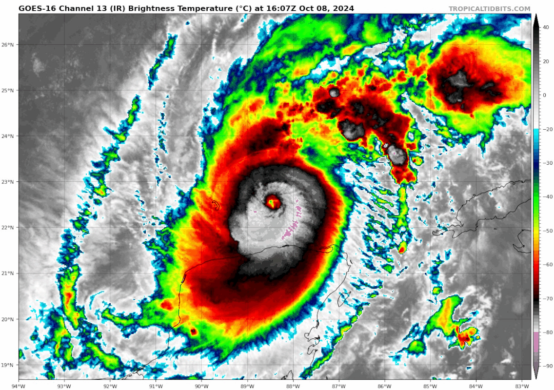
Eye temps are almost positive again, a solid CMG ring is present and a large area of CDG is in the north and spreading around in the last few frames. If this is what Milton looks like now I hate to see what will happen later today and tonight over the loop current.

Last edited by Travorum on Tue Oct 08, 2024 12:32 pm, edited 1 time in total.
2 likes

Re: ATL: MILTON - Hurricane - Discussion: 150 mph / 929 mbs
sicktght311 wrote:I know everyone's focused on Tampa, but I feel like the secondary large story not getting enough is Ft Myers and Cape Coral after already getting decimated by Ian. With a track anywhere north of Sarasota, FM and CC are going to get destroyed again by surge
or the massive flooding that will occur in central florida...but this happens with every storm, 99% of the focus is on the landfall but just as much destruction happens many miles away
2 likes
Just like Jon Snow..."I know nothing" except what I know, and most of what I know is gathered by the fine people of the NHC
-
ElectricStorm

- Category 5

- Posts: 5125
- Age: 25
- Joined: Tue Aug 13, 2019 11:23 pm
- Location: Norman, OK
Re: ATL: MILTON - Hurricane - Discussion: 150 mph / 929 mbs
Anyone know when next recon is? Hopefully we don't have to wait as long as yesterday.
Still think this will get close to what it was yesterday with maybe slightly higher pressure but similar winds
Still think this will get close to what it was yesterday with maybe slightly higher pressure but similar winds
1 likes
B.S Meteorology, University of Oklahoma '25
Please refer to the NHC, NWS, or SPC for official information.
Please refer to the NHC, NWS, or SPC for official information.
-
tropicwatch

- Category 5
- Posts: 3426
- Age: 62
- Joined: Sat Jun 02, 2007 10:01 am
- Location: Panama City Florida
- Contact:
Re: ATL: MILTON - Hurricane - Discussion: 150 mph / 929 mbs
Hopefully AF HH will do one more center pass. Have not seen a VDM from the last one yet.
0 likes
Tropicwatch
Agnes 72', Eloise 75, Elena 85', Kate 85', Charley 86', Florence 88', Beryl 94', Dean 95', Erin 95', Opal 95', Earl 98', Georges 98', Ivan 2004', Arlene 2005', Dennis 2005', Ida 2009' Debby 2012' Irma 2017' Michael 2018'
Agnes 72', Eloise 75, Elena 85', Kate 85', Charley 86', Florence 88', Beryl 94', Dean 95', Erin 95', Opal 95', Earl 98', Georges 98', Ivan 2004', Arlene 2005', Dennis 2005', Ida 2009' Debby 2012' Irma 2017' Michael 2018'

Re: ATL: MILTON - Hurricane - Discussion: 150 mph / 929 mbs
tolakram wrote:technikal wrote:sicktght311 wrote:Its a reminder to some folks here who are quick to comment "its weakening", as well as people in the media, to look at things from a larger perspective, and consider that it can play with people's lives. People are impressionable, dumb, and short sighted. Everyone tries to balance risk vs optimism, but its always just a reminder that the only optimistic way to mitigate risk is to avoid it. If its dangerous now, treat it as if it will be just as dangerous in 48 hours
While I agree everyone should still treat it like the threat it is, the forecasted weakening on models like HAFS-B is significant (like +40mb) and that should be communicated to avoid sensationalism. Yes, it’s one of the most powerful hurricanes ever, but we know with a pretty high degree of confidence that it won’t make landfall at that intensity. It’s in the public interest to (cautiously) let that be known.
I disagree, unless we can agree on what weakening means. Less surge, less wind, less overall impact? The mission statement of the NHC is: To save lives, mitigate property loss, and improve economic efficiency by issuing the best watches, warnings, forecasts and analyses of hazardous tropical weather, and by increasing understanding of these hazards through global outreach.
How does mentioning the barometric pressure or wind speed of a storm is weakening while the most dangerous part of the storm, the surge, is not fit into that statement. Katrina was weakening. The NHC doesn't report on the whims of every model.
I think the NHC’s discussion and suite of products cover all of the bases of potential threats, including storm surge. The tone of their discussions has consistently been “it will likely weaken before landfall, but still be an extremely dangerous event,” which is the right tone to strike IMO. You still need to issue an accurate forecast. It would be irresponsible to let people believe it’s going to be sub-900 monster at landfall, mainly because it erodes trust in the forecast and makes people more likely to brush off the next serious hurricane threat.
Thankfully NHC has a very, very high degree of public trust because they are more accurate than anyone and they do a great job of balancing strong messaging of risks with responsible forecasting.
1 likes

Re: ATL: MILTON - Hurricane - Discussion: 150 mph / 929 mbs
Correction, we may just jump straight to a T 7.5
2 likes
Very useful information on the Dvorak Technique --
https://severe.worldweather.wmo.int/TCF ... kBeven.pdf
https://severe.worldweather.wmo.int/TCF ... kBeven.pdf
-
dukeblue219
- S2K Supporter
- Posts: 556
- Joined: Fri Sep 30, 2016 3:52 pm
Re: ATL: MILTON - Hurricane - Discussion: 150 mph / 929 mbs
tropicwatch wrote:Hopefully AF HH will do one more center pass. Have not seen a VDM from the last one yet.
They're climbing back to cruise altitude, presumably done for the flight.
2 likes
-
InfernoFlameCat

- Category 5
- Posts: 2127
- Age: 22
- Joined: Mon Dec 14, 2020 10:52 am
- Location: Buford, GA
Re: ATL: MILTON - Hurricane - Discussion: 150 mph / 929 mbs
With this rapidly improving Milton, i would pull the trigger and go cat 5 at 2 pm edt. Clearly will be a cat 5 in the next hour.
3 likes
I am by no means a professional. DO NOT look at my forecasts for official information or make decisions based on what I post.
Goal: to become a registered expert over tropical and subtropical cyclones.
Goal: to become a registered expert over tropical and subtropical cyclones.

Re: ATL: MILTON - Hurricane - Discussion: 150 mph / 929 mbs
There are no signs of on EWRC and due to the lack of land interaction and increasing OHC, Milton should be off to the races again. So, unlike yesterday, I'm quite confident that the next recon mission will arrive well before Milton weakens again.
4 likes

Re: ATL: MILTON - Hurricane - Discussion: 150 mph / 929 mbs
ElectricStorm wrote:Anyone know when next recon is? Hopefully we don't have to wait as long as yesterday.
Still think this will get close to what it was yesterday with maybe slightly higher pressure but similar winds
I’d be fine with a gap similar to yesterday if that means we get recon perfectly timed with Milton’s passage over the Loop Current later today. We might be in store for another crazy peak and flight.
Praying shear kicks in afterwards and knocks this down at least 2 categories before landfall tomorrow.
0 likes
Irene '11 Sandy '12 Hermine '16 5/15/2018 Derecho Fay '20 Isaias '20 Elsa '21 Henri '21 Ida '21
I am only a meteorology enthusiast who knows a decent amount about tropical cyclones. Look to the professional mets, the NHC, or your local weather office for the best information.
I am only a meteorology enthusiast who knows a decent amount about tropical cyclones. Look to the professional mets, the NHC, or your local weather office for the best information.
-
tolakram
- Admin
- Posts: 20173
- Age: 62
- Joined: Sun Aug 27, 2006 8:23 pm
- Location: Florence, KY (name is Mark)
Re: ATL: MILTON - Hurricane - Discussion: 150 mph / 929 mbs

12 likes
M a r k
- - - - -
Join us in chat: Storm2K Chatroom Invite. Android and IOS apps also available.
The posts in this forum are NOT official forecasts and should not be used as such. Posts are NOT endorsed by any professional institution or STORM2K.org. For official information and forecasts, please refer to NHC and NWS products.
- - - - -
Join us in chat: Storm2K Chatroom Invite. Android and IOS apps also available.
The posts in this forum are NOT official forecasts and should not be used as such. Posts are NOT endorsed by any professional institution or STORM2K.org. For official information and forecasts, please refer to NHC and NWS products.
-
dukeblue219
- S2K Supporter
- Posts: 556
- Joined: Fri Sep 30, 2016 3:52 pm
Re: ATL: MILTON - Hurricane - Discussion: 150 mph / 929 mbs
ElectricStorm wrote:Anyone know when next recon is?
Plans are published on the NHC website: https://www.nhc.noaa.gov/text/MIAREPRPD_last.shtml?
Next center fix around 430pm EDT (TEAL 73).
Since folks having been asking, there's also this note:
DURING THE NOAA 43 MISSION TASKED IN TCPOD 24-128 FOR THE
08/1200Z SYNOPTIC TIME, ONE SMALL UAS IS PLANNED FOR
RELEASE AT IN THE CENTER OF MILTON AT APPROXIMATELY
08/0925Z. IT WILL OPERATE AT OR BELOW 5,000 FT FOR
ABOUT 1 TO 1.5 HOURS.
C. DURING THE NOAA 42 MISSION TASKED ABOVE, ONE SMALL UAS
IS PLANNED FOR RELEASE IN MILTON'S CENTER AT APPROXIMATELY
08/2115Z. IT WILL OPERATE AT OR BELOW 5,000 FT FOR
ABOUT 1 TO 1.5 HOURS.
Last edited by dukeblue219 on Tue Oct 08, 2024 12:38 pm, edited 1 time in total.
1 likes
-
cycloneye

- Admin
- Posts: 149156
- Age: 69
- Joined: Thu Oct 10, 2002 10:54 am
- Location: San Juan, Puerto Rico
Re: ATL: MILTON - Hurricane - Discussion: 150 mph / 929 mbs
The AF mission is over but we will not have to wait too long as yesterday to have the next one because the new mission will depart around 2:45 PM EDT.
6 likes
Visit the Caribbean-Central America Weather Thread where you can find at first post web cams,radars
and observations from Caribbean basin members Click Here
and observations from Caribbean basin members Click Here
Re: ATL: MILTON - Hurricane - Discussion: 150 mph / 929 mbs
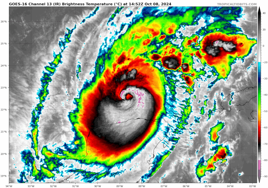
Teban54 wrote:That's quite a comeback. Milton certainly wants to get back to the top echelon of hurricanes yet again, even if not necessarily sub-900.
https://i.postimg.cc/W3W0ssHm/goes16-ir-14-L-202410081452.gif
Milton is getting free of land interaction, and approaching the loop current. The shear increase is still a good 12-18 hrs off. So he should be firing on all engines.
1 likes
Re: ATL: MILTON - Hurricane - Discussion: 150 mph / 929 mbs
Clear T 7.0 right now. They have just cause to set it to 140 knots
1 likes
Very useful information on the Dvorak Technique --
https://severe.worldweather.wmo.int/TCF ... kBeven.pdf
https://severe.worldweather.wmo.int/TCF ... kBeven.pdf
-
tolakram
- Admin
- Posts: 20173
- Age: 62
- Joined: Sun Aug 27, 2006 8:23 pm
- Location: Florence, KY (name is Mark)
Re: ATL: MILTON - Hurricane - Discussion: 150 mph / 929 mbs

12 likes
M a r k
- - - - -
Join us in chat: Storm2K Chatroom Invite. Android and IOS apps also available.
The posts in this forum are NOT official forecasts and should not be used as such. Posts are NOT endorsed by any professional institution or STORM2K.org. For official information and forecasts, please refer to NHC and NWS products.
- - - - -
Join us in chat: Storm2K Chatroom Invite. Android and IOS apps also available.
The posts in this forum are NOT official forecasts and should not be used as such. Posts are NOT endorsed by any professional institution or STORM2K.org. For official information and forecasts, please refer to NHC and NWS products.

Re: ATL: MILTON - Hurricane - Discussion: 150 mph / 929 mbs
GCANE wrote:Area of max ionospheric heating underway.
DISCLAIMER:
There is no published, mainstream scientific proof that hurricane intensification is directly related to ionospheric heating.
I am just pointing out the strong correlation for the past three days.
Super interesting imho especially considering time of day.
7 likes
Who is online
Users browsing this forum: No registered users and 43 guests