ATL: MILTON - Post-Tropical - Discussion
Moderator: S2k Moderators

Re: ATL: MILTON - Hurricane - Discussion: 155 mph / 923 mbs
Doesn't happen often but I hope recon arrives as late as possible. This is a stable RI phase and Milton is most likely already a cat 5. I'm afraid the mission after the upcoming one will arrive after an EWRC, so if the upcoming mission is too early we might miss the peak again. So don't hurry recon and who knows, Milton might be T7.5 or higher by the time you arrive.
7 likes
Re: ATL: MILTON - Hurricane - Discussion: 150 mph / 929 mbs
Steve wrote:ConvergenceZone wrote:BobHarlem wrote:
Mark Sudduth/Hurricanetrack is usually the most interesting as far as cameras go.
Thanks, noted as well. Although I admit, I've always been a Jim Cantore fanboy. Of course he may not end up where Milton goes lol.
It’s a whole different world than Cantore. Mark will seek out eyewalls and the like for the most action there is. Just an FYI
Cantore seems to be limited by what and where the Weather Channel will let him do. Would love to see him freelance like the other chasers listed here.
2 likes
-
TomballEd
- Category 5

- Posts: 1246
- Age: 62
- Joined: Wed Aug 16, 2023 4:52 pm
- Location: Spring/Klein area, not Tomball
Re: ATL: MILTON - Hurricane - Discussion: 150 mph / 929 mbs
Mjm1111 wrote:Steve wrote:ConvergenceZone wrote:
Thanks, noted as well. Although I admit, I've always been a Jim Cantore fanboy. Of course he may not end up where Milton goes lol.
It’s a whole different world than Cantore. Mark will seek out eyewalls and the like for the most action there is. Just an FYI
Cantore seems to be limited by what and where the Weather Channel will let him do. Would love to see him freelance like the other chasers listed here.
He'd be risking his production crew if he tried for ultimate YouTube clickbait destruction videos.
2 likes
-
WaveBreaking

- Category 2

- Posts: 713
- Joined: Sun Jun 30, 2024 11:33 am
- Location: US
Re: ATL: MILTON - Hurricane - Discussion: 155 mph / 923 mbs
Looks really good again today.

10 likes
I am NOT a professional meteorologist, so take all of my posts with a grain of salt. My opinions are mine and mine alone.

Re: ATL: MILTON - Hurricane - Discussion: 155 mph / 923 mbs
SWFWMD is dumping water out of lake tarpon as fast as they can. A downstream current is evident in the outfall canal and the lake is down a good bit....a very prudent course of action considering the likely rain bomb incoming. Just made a final trip to publix before everything shuts down at 3.
4 likes
Re: ATL: MILTON - Hurricane - Discussion: 155 mph / 923 mbs
Raw T# now up to 7.5 aka 906mb/155kt. It'll take some time for the storm to catch up to its appearance, but Milton might actually be making another run at low 900s or even sub-900 pressure.
4 likes

Re: ATL: MILTON - Hurricane - Discussion: 155 mph / 923 mbs
kevin wrote:Doesn't happen often but I hope recon arrives as late as possible. This is a stable RI phase and Milton is most likely already a cat 5. I'm afraid the mission after the upcoming one will arrive after an EWRC, so if the upcoming mission is too early we might miss the peak again. So don't hurry recon and who knows, Milton might be T7.5 or higher by the time you arrive.
Next recon is supposed to get there at 4:30pm EST, right? That should be in time to catch its peak with 3-5 center fixes. Plus any recon that arrives 1-2 hours later.
1 likes
Irene '11 Sandy '12 Hermine '16 5/15/2018 Derecho Fay '20 Isaias '20 Elsa '21 Henri '21 Ida '21
I am only a meteorology enthusiast who knows a decent amount about tropical cyclones. Look to the professional mets, the NHC, or your local weather office for the best information.
I am only a meteorology enthusiast who knows a decent amount about tropical cyclones. Look to the professional mets, the NHC, or your local weather office for the best information.
-
Stormybajan

- Category 1

- Posts: 453
- Joined: Thu May 20, 2021 3:21 pm
- Location: Windward Islands
Re: ATL: MILTON - Hurricane - Discussion: 155 mph / 923 mbs
Based on 18z ATCF, Milton is now once again a 920 mb , 160 mph Category 5 hurricane! First time I think weve had a hurricane with two category 5 peaks since Hurricane Maria of 2017! Astonishing what weve witnessed this season between Beryl, Helene, Kirk and now Mega Milton!
EDIT: Was too hasty to check but Maria actually had TWO category 5 peaks so Milton is the first since then!
EDIT: Was too hasty to check but Maria actually had TWO category 5 peaks so Milton is the first since then!
Last edited by Stormybajan on Tue Oct 08, 2024 1:54 pm, edited 1 time in total.
6 likes
Sad West Indies and Manchester United fan ⚽️
-
FLLurker32
- Tropical Storm

- Posts: 245
- Joined: Mon Aug 29, 2016 10:31 am
Re: ATL: MILTON - Hurricane - Discussion: 155 mph / 923 mbs
Does anyone know if zoom earth is accurate with their location pin on the path?
Looking at it, Milton has wobbled an incredible amount. If that’s real, it’s something that can make a larger than normal impact at landfall. The various landfall points the models have went back and forth on are not really all that far apart. They just seem like it from the unique shape of the coastline.
Looking at it, Milton has wobbled an incredible amount. If that’s real, it’s something that can make a larger than normal impact at landfall. The various landfall points the models have went back and forth on are not really all that far apart. They just seem like it from the unique shape of the coastline.
0 likes
Heather
Re: ATL: MILTON - Hurricane - Discussion: 155 mph / 923 mbs
aspen wrote:kevin wrote:Doesn't happen often but I hope recon arrives as late as possible. This is a stable RI phase and Milton is most likely already a cat 5. I'm afraid the mission after the upcoming one will arrive after an EWRC, so if the upcoming mission is too early we might miss the peak again. So don't hurry recon and who knows, Milton might be T7.5 or higher by the time you arrive.
Next recon is supposed to get there at 4:30pm EST, right? That should be in time to catch its peak with 3-5 center fixes. Plus any recon that arrives 1-2 hours later.
Yes you're right. If I recall correctly we're up to 3-hourly fixes from now on. In that case recon will be there to witness the secondary peak.
0 likes
-
floridasun
- Tropical Storm
- Posts: 245
- Joined: Tue Sep 14, 2021 3:59 pm
Re: ATL: MILTON - Hurricane - Discussion: 155 mph / 923 mbs
tending more closer to fort mayer area bit south of tampa area i hope people that area looking at nhc adv.
0 likes
Re: ATL: MILTON - Hurricane - Discussion: 155 mph / 923 mbs
Is it just me, or is there a bit of a moat seen on Tropical Tidbits IR imagery? Or is it just a random slightly warmer patch of the CDO?
0 likes
Irene '11 Sandy '12 Hermine '16 5/15/2018 Derecho Fay '20 Isaias '20 Elsa '21 Henri '21 Ida '21
I am only a meteorology enthusiast who knows a decent amount about tropical cyclones. Look to the professional mets, the NHC, or your local weather office for the best information.
I am only a meteorology enthusiast who knows a decent amount about tropical cyclones. Look to the professional mets, the NHC, or your local weather office for the best information.
-
Hypercane_Kyle

- Category 5
- Posts: 3465
- Joined: Sat Mar 07, 2015 7:58 pm
- Location: Cape Canaveral, FL
Re: ATL: MILTON - Hurricane - Discussion: 155 mph / 923 mbs
Hurricane MILTON
As of 18:00 UTC Oct 08, 2024:
Location: 22.5°N 88.1°W
Maximum Winds: 140 kt Gusts: N/A
Minimum Central Pressure: 920 mb
Environmental Pressure: N/A
Radius of Circulation: N/A
Radius of Maximum wind: 10 nm
64 kt Wind Radii by Quadrant:
As of 18:00 UTC Oct 08, 2024:
Location: 22.5°N 88.1°W
Maximum Winds: 140 kt Gusts: N/A
Minimum Central Pressure: 920 mb
Environmental Pressure: N/A
Radius of Circulation: N/A
Radius of Maximum wind: 10 nm
64 kt Wind Radii by Quadrant:
2 likes
My posts are my own personal opinion, defer to the National Hurricane Center (NHC) and other NOAA products for decision making during hurricane season.

Re: ATL: MILTON - Hurricane - Discussion: 155 mph / 923 mbs
Stormybajan wrote:Based on 18z ATCF, Milton is now once again a 920 mb , 160 mph Category 5 hurricane! First time I think weve had a hurricane with two category 5 peaks since the Godmother of MDR Hurricanes in Irma of 2017! Astonishing what weve witnessed this season between Beryl, Helene, Kirk and now Mega Milton!
yep, 18z best track:
AL, 14, 2024100818, , BEST, 0, 225N, 881W, 140, 920, HU
Last edited by Travorum on Tue Oct 08, 2024 1:48 pm, edited 1 time in total.
1 likes
-
BIFF_THE_UNRULY
- Tropical Storm
- Posts: 143
- Joined: Fri Jun 28, 2024 2:12 pm
Re: ATL: MILTON - Hurricane - Discussion: 155 mph / 923 mbs
psyclone wrote:SWFWMD is dumping water out of lake tarpon as fast as they can. A downstream current is evident in the outfall canal and the lake is down a good bit....a very prudent course of action considering the likely rain bomb incoming. Just made a final trip to publix before everything shuts down at 3.
Thats interesting, I didnt know they could do that.
Given
the Vicinity of Aneclote and Salt Lake. Very wise.
2 likes
-
shear_vector
- Tropical Wave

- Posts: 7
- Joined: Sat Aug 24, 2024 9:16 am
Re: ATL: MILTON - Hurricane - Discussion: 155 mph / 923 mbs
GCANE wrote:There seems to be a sudden jump up in the intensity of the ionospheric heating
https://solarham.com/globald.htm
Space weather and tropical cyclones would be a great thread over in 'Talkin' Tropics' since there is a lot of space weather data/brief discussion being posted in this discussion thread I wanted to point out one important part I see data and propose further discussion of space weather and tropical cyclones become a new thread in 'Talkin' Tropics'.
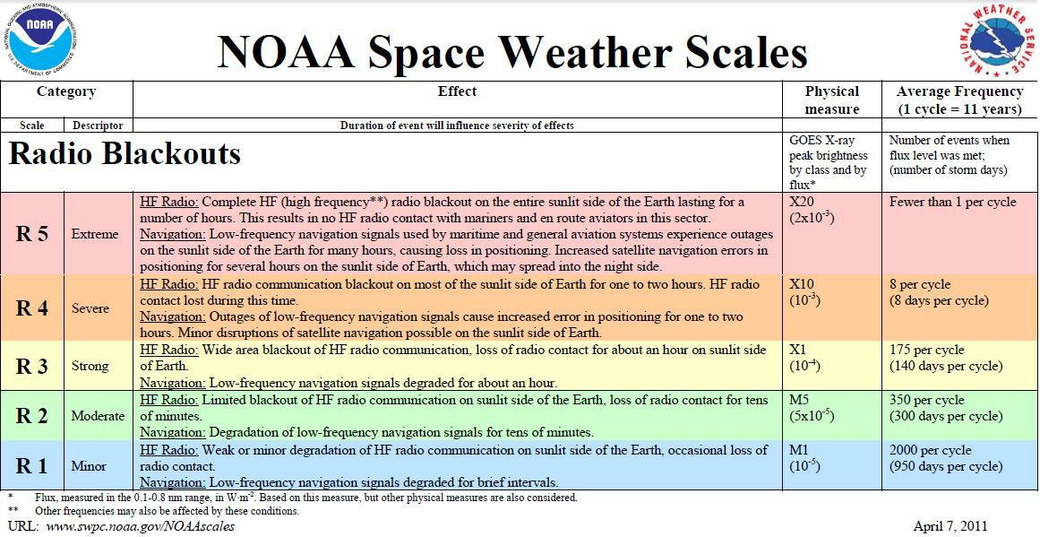
I'm not sure if the 'sudden jump in intensity' is in reference to the Y-axis of the Solar X-Ray Flux chart or perhaps I am missing something here. The Radio Blackout Level or the scale used to measure Radio Blackouts which denotes the different levels as R0-5 I believe would be categorized as exponential not linear. At the time of the above quoted post during the 'sudden jump' in the Radio Blackout Level remained at the R0 level and it continues to remain at the R0, again, on an exponential scale. I'm going to leave it at that.
All I am going to say is this is I do think it is irresponsible to speculate about space weather and tropical cyclones especially without any context of what you the data that is up for (mis)interpretation actually means. Considering the situation it's time to leave speculation at the door.
Finally I will post this from the 'D-Region Adsorption Predictions (DRAP)' product page from the SWPC website..
The D-Region Absorption Product addresses the operational impact of the solar X-ray flux and SEP events on HF radio communication. Long-range communications using high frequency (HF) radio waves (3 - 30 MHz) depend on reflection of the signals in the ionosphere. Radio waves are typically reflected near the peak of the F2 layer (~300 km altitude), but along the path to the F2 peak and back the radio wave signal suffers attenuation due to absorption by the intervening ionosphere.
The D-Region Absorption Prediction model is used as guidance to understand the HF radio degradation and blackouts this can cause.
Source in the 'Impacts' tab: https://www.swpc.noaa.gov/products/d-re ... ions-d-rap
Finally, leaving a link for information on the Radio Blackout Level scale: https://www.weather.gov/images/akq/Brie ... sScale.jpg
I'm no expert and I would love to be apart of a general science based sharing of information/discussion on this topic, but not in this thread.
3 likes

Re: ATL: MILTON - Hurricane - Discussion: 150 mph / 929 mbs
ConvergenceZone wrote:Steve wrote:ConvergenceZone wrote:Hopefully someone can answer this, but does anyone know if stations like the weather channel or fox weather still have live reporting landfall footage even if the storms landfalls in the middle of the night? I have never stayed up to watch on previous storms, so I have no idea, but I mean if the storm comes in around 2:00 AM, will there still be live reporters at those locations? or do they only do that if it landfalls during the day/evening? Thanks.
Probably. But there are way better options. Ryan Hall and his team usually feature simultaneous live feeds of multiple chasers cameras and products and go live. Also many individual chasers are out there on YouTube and Signal - Josh Morgerman, Vince Waelti, Brandon Copic, Reed Timmer, etc. trust me when I’m telling you those live feeds are immensely better. Second to those are local station feeds. Much much better than TWC and Fox.
Thanks Steve, but I'll probably just stick with the pro mets and those that have more experience when it comes to hurricanes. I love Ryan when it comes to Tornadoes, although many times the signal goes in and out which is frustrating, same with Vince. But I've caught Ryan saying many inaccuracies when it comes to hurricanes due to lack of experience/education. ... Also it has to be something I get on my ROKU TV as I hate watching footage on my PC. Screen is too small. But thanks. I appreciate it though.
NewsON is an app that you can get on your electronic devices or SmartTV that has links to Local Stations.
It's a great way to follow the storm and landfall.
I used it with Helene to watch the Tallahassee station until it went off the air and I switched to Southern GA stations.
There is also LocalNow where you can select a station to watch coverage on.
1 likes
Personal Forecast Disclaimer:
My posts are just my opinion and are most likely not backed by sound meteorological data. They are NOT endorsed by any professional institution or storm2k.org. For official information, please refer to the NHC and NWS products.
Bottom line is that I am just expressing my opinion!!!
My posts are just my opinion and are most likely not backed by sound meteorological data. They are NOT endorsed by any professional institution or storm2k.org. For official information, please refer to the NHC and NWS products.
Bottom line is that I am just expressing my opinion!!!

Re: ATL: MILTON - Hurricane - Discussion: 155 mph / 923 mbs
CDO symmetry is looking better. I suspect this will make a good run back towards 900 mb this evening.
6 likes
Very useful information on the Dvorak Technique --
https://severe.worldweather.wmo.int/TCF ... kBeven.pdf
https://severe.worldweather.wmo.int/TCF ... kBeven.pdf
Re: ATL: MILTON - Hurricane - Discussion: 155 mph / 923 mbs
aspen wrote:Is it just me, or is there a bit of a moat seen on Tropical Tidbits IR imagery? Or is it just a random slightly warmer patch of the CDO?
Northwest eyewall you mean? I sorta see it
0 likes
Very useful information on the Dvorak Technique --
https://severe.worldweather.wmo.int/TCF ... kBeven.pdf
https://severe.worldweather.wmo.int/TCF ... kBeven.pdf
-
HurricaneAndre2008

- Category 1
- Posts: 356
- Age: 28
- Joined: Wed Jul 31, 2019 9:51 pm
- Contact:
Re: ATL: MILTON - Hurricane - Discussion: 155 mph / 923 mbs
AL, 14, 2024100818, 01, CARQ, 0, 225N, 881W, 140, 920, HU, 64, NEQ, 25, 25, 25, 25, 1005, 240, 10, 0, 0, L, 0, X, 70, 7, MILTON, D,
0 likes
Cindy(2005), Katrina(2005), Rita(2005), Erin(2007), Isaac(2012)
Who is online
Users browsing this forum: No registered users and 33 guests