ATL: ERNESTO - Post-Tropical - Discussion
Moderator: S2k Moderators

Re: ATL: ERNESTO - Hurricane - Discussion
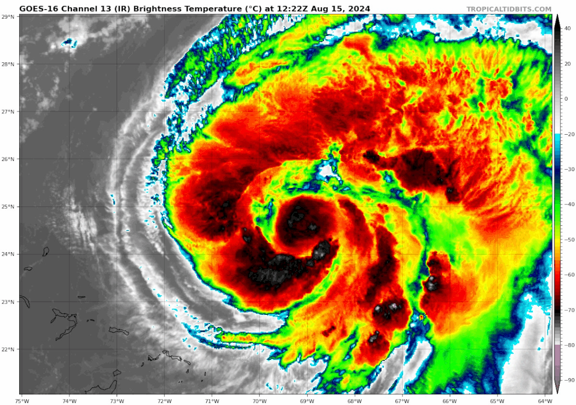
The ferocity of the outer eyewall on a IR or VIS loop is impressive. It's almost looks like it's attacking the 'core'. Not so much an EWRC since I'm not sure an organized inner core even exists. I have no clue how those anomalously large eyes form, but does anyone think a (less extreme) case of typhoon Winnie is possible where the inner core just collapses and we're left with a very large eye?
Last edited by kevin on Thu Aug 15, 2024 8:44 am, edited 1 time in total.
0 likes
-
cheezyWXguy

- Category 5

- Posts: 6282
- Joined: Mon Feb 13, 2006 12:29 am
- Location: Dallas, TX
Re: ATL: ERNESTO - Hurricane - Discussion
WaveBreaking wrote:Partial microwave pass shows a pretty weak inner core surrounded by a much stronger band to the N. Eyewall wasn’t captured well by the pass so it may be stronger. Regardless, this seems like a setup for an EWRC later today or tomorrow.
https://i.imgur.com/KLpQlz0.jpeg
To be honest, I don’t think that depiction of the inner eyewall is inaccurate. It looks like Ernesto has been undergoing an erc for a while now and the outer eyewall is rapidly contracting while taking over. Still has a lot of work to do though
2 likes

Re: ATL: ERNESTO - Hurricane - Discussion
That outer eyewall is getting a lot more pronounced on visible imagery. I think we should see it solidify and clear before shear picks up in 18-36 hours (the exact timeframe still varies between models).
0 likes
Irene '11 Sandy '12 Hermine '16 5/15/2018 Derecho Fay '20 Isaias '20 Elsa '21 Henri '21 Ida '21
I am only a meteorology enthusiast who knows a decent amount about tropical cyclones. Look to the professional mets, the NHC, or your local weather office for the best information.
I am only a meteorology enthusiast who knows a decent amount about tropical cyclones. Look to the professional mets, the NHC, or your local weather office for the best information.
-
WeatherBoy2000
- Category 1

- Posts: 463
- Joined: Mon Apr 10, 2023 9:29 am
Re: ATL: ERNESTO - Hurricane - Discussion
Ernesto's core is a disorganized mess, I won't be surprised if the NHC rolls back their prediction of a major hurricane very soon at this rate.
1 likes


Re: ATL: ERNESTO - Hurricane - Discussion
cheezyWXguy wrote:WaveBreaking wrote:Partial microwave pass shows a pretty weak inner core surrounded by a much stronger band to the N. Eyewall wasn’t captured well by the pass so it may be stronger. Regardless, this seems like a setup for an EWRC later today or tomorrow.
https://i.imgur.com/KLpQlz0.jpeg
To be honest, I don’t think that depiction of the inner eyewall is inaccurate. It looks like Ernesto has been undergoing an erc for a while now and the outer eyewall is rapidly contracting while taking over. Still has a lot of work to do though
Here's the full picture, it looks like the dry air that was entrained disrupted the western/southwestern eyewall (which as of last night hadn't fully developed) and the outer band is taking over.

2 likes
-
HurricaneBelle

- S2K Supporter

- Posts: 1209
- Joined: Sun Aug 27, 2006 6:12 pm
- Location: Clearwater, FL
Re: ATL: ERNESTO - Hurricane - Discussion
cheezyWXguy wrote:To be honest, I don’t think that depiction of the inner eyewall is inaccurate. It looks like Ernesto has been undergoing an erc for a while now and the outer eyewall is rapidly contracting while taking over. Still has a lot of work to do though
To have an EWRC you have to have an eyewall in the first place.
2 likes
-
cheezyWXguy
- Category 5
- Posts: 6282
- Joined: Mon Feb 13, 2006 12:29 am
- Location: Dallas, TX
Re: ATL: ERNESTO - Hurricane - Discussion
HurricaneBelle wrote:cheezyWXguy wrote:To be honest, I don’t think that depiction of the inner eyewall is inaccurate. It looks like Ernesto has been undergoing an erc for a while now and the outer eyewall is rapidly contracting while taking over. Still has a lot of work to do though
To have an EWRC you have to have an eyewall in the first place.
We did, it existed since at least yesterday morning.
2 likes

Re: ATL: ERNESTO - Hurricane - Discussion
The outer eyewall is getting more pronounced minute by minute and almost wrapping around. Dry air doesn't seem to be a big issue this morning, so if this continues, Ernesto will likely have time for further intensification once the EWRC is complete.
1 likes
TC naming lists: retirements and intensity
Most aggressive Advisory #1's in North Atlantic (cr. kevin for starting the list)
Most aggressive Advisory #1's in North Atlantic (cr. kevin for starting the list)
Re: ATL: ERNESTO - Hurricane - Discussion
WeatherBoy2000 wrote:Ernesto's core is a disorganized mess, I won't be surprised if the NHC rolls back their prediction of a major hurricane very soon at this rate.
Yep, they dropped it to 95 kt for the 11am advisory.
1 likes
Irene '11 Sandy '12 Hermine '16 5/15/2018 Derecho Fay '20 Isaias '20 Elsa '21 Henri '21 Ida '21
I am only a meteorology enthusiast who knows a decent amount about tropical cyclones. Look to the professional mets, the NHC, or your local weather office for the best information.
I am only a meteorology enthusiast who knows a decent amount about tropical cyclones. Look to the professional mets, the NHC, or your local weather office for the best information.
Re: ATL: ERNESTO - Hurricane - Discussion
I can't upload images rn, but go look at Ernesto on IR or VIS. It's so cool, looks like a curled up shrimp. Not a lot of meteorological value in this post, but just wanted to share  .
.
3 likes
-
ElectricStorm

- Category 5
- Posts: 5152
- Age: 25
- Joined: Tue Aug 13, 2019 11:23 pm
- Location: Norman, OK
Re: ATL: ERNESTO - Hurricane - Discussion
Latest recon pass supports around 75kts/974mb although once again the strongest winds are well removed from the center.
2 likes
B.S Meteorology, University of Oklahoma '25
Please refer to the NHC, NWS, or SPC for official information.
Please refer to the NHC, NWS, or SPC for official information.
-
USTropics
- Professional-Met

- Posts: 2739
- Joined: Sun Aug 12, 2007 3:45 am
- Location: Florida State University
Re: ATL: ERNESTO - Hurricane - Discussion
kevin wrote:I can't upload images rn, but go look at Ernesto on IR or VIS. It's so cool, looks like a curled up shrimp. Not a lot of meteorological value in this post, but just wanted to share
Here are some custom extents with images starting from this morning:
1 likes

Re: ATL: ERNESTO - Hurricane - Discussion
974 mb is pretty low and the structure is becoming more symmetrical so will probably continue to deepen.
Trough isn't reaching the outflow yet and Bermuda is still too close to the track for this.
Trough isn't reaching the outflow yet and Bermuda is still too close to the track for this.
1 likes
-
Sciencerocks
- Category 5
- Posts: 10189
- Age: 40
- Joined: Thu Jul 06, 2017 1:51 am

-
cheezyWXguy
- Category 5
- Posts: 6282
- Joined: Mon Feb 13, 2006 12:29 am
- Location: Dallas, TX
Re: ATL: ERNESTO - Hurricane - Discussion
Those large outer bands are starting to weaken, this may be an effort to consolidate energy closer to the center which would help it strengthen
0 likes

Re: ATL: ERNESTO - Hurricane - Discussion
Not strengthening very quickly but it has a large area of hurricane force winds to the east. Bermuda will have a decent stretch of 65kt+ winds. Luckily it shouldn’t be too bad as we are no stranger to direct cat 1-2 impacts- seems to occur every couple of years.
3 likes
Igor 2010, Sandy 2012, Fay 2014, Gonzalo 2014, Joaquin 2015, Nicole 2016, Humberto 2019, Imelda 2025
I am only a tropical weather enthusiast. My predictions are not official and may or may not be backed by sound meteorological data. For official information, please refer to the NHC and NWS products.
I am only a tropical weather enthusiast. My predictions are not official and may or may not be backed by sound meteorological data. For official information, please refer to the NHC and NWS products.
-
cycloneye

- Admin

- Posts: 149688
- Age: 69
- Joined: Thu Oct 10, 2002 10:54 am
- Location: San Juan, Puerto Rico
Re: ATL: ERNESTO - Hurricane - Discussion
Perfect ASCAT pass. Wow.

11 likes
Visit the Caribbean-Central America Weather Thread where you can find at first post web cams,radars
and observations from Caribbean basin members Click Here
and observations from Caribbean basin members Click Here
Re: ATL: ERNESTO - Hurricane - Discussion
Kazmit wrote:Not strengthening very quickly but it has a large area of hurricane force winds to the east. Bermuda will have a decent stretch of 65kt+ winds. Luckily it shouldn’t be too bad as we are no stranger to direct cat 1-2 impacts- seems to occur every couple of years.
One thing that ACE and SS scale don’t reflect on well is diameter of strong winds/size of storm.
2 likes
Personal Forecast Disclaimer:
The posts in this forum are NOT official forecasts and should not be used as such. They are just the opinion of the poster and may or may not be backed by sound meteorological data. They are NOT endorsed by any professional institution or storm2k.org. For official information, please refer to the NHC and NWS products.
The posts in this forum are NOT official forecasts and should not be used as such. They are just the opinion of the poster and may or may not be backed by sound meteorological data. They are NOT endorsed by any professional institution or storm2k.org. For official information, please refer to the NHC and NWS products.
Re: ATL: ERNESTO - Hurricane - Discussion
EWRC is well underway, the western tower rotating around on IR might be close to closing the outer eyewall off by now.

3 likes
Re: ATL: ERNESTO - Hurricane - Discussion
LarryWx wrote:Kazmit wrote:Not strengthening very quickly but it has a large area of hurricane force winds to the east. Bermuda will have a decent stretch of 65kt+ winds. Luckily it shouldn’t be too bad as we are no stranger to direct cat 1-2 impacts- seems to occur every couple of years.
One thing that ACE and SS scale don’t reflect on well is diameter of strong winds/size of storm.
Someone should develop a system like ACE using pressure instead of wind speed as a metric.
1 likes
Igor 2010, Sandy 2012, Fay 2014, Gonzalo 2014, Joaquin 2015, Nicole 2016, Humberto 2019, Imelda 2025
I am only a tropical weather enthusiast. My predictions are not official and may or may not be backed by sound meteorological data. For official information, please refer to the NHC and NWS products.
I am only a tropical weather enthusiast. My predictions are not official and may or may not be backed by sound meteorological data. For official information, please refer to the NHC and NWS products.
Who is online
Users browsing this forum: No registered users and 75 guests