ATL: MILTON - Models
Moderator: S2k Moderators
Re: ATL: MILTON - Models
00z Euro run is essentially only further south because it's weaker all the way through than the 12z.
0 likes
-
AtlanticWind

- S2K Supporter

- Posts: 1898
- Age: 67
- Joined: Sun Aug 08, 2004 9:57 pm
- Location: Plantation,Fla
Re: ATL: MILTON - Models
00z models generally came in a little south tonight
See if it’s a trend or not on Sunday
See if it’s a trend or not on Sunday
0 likes


Re: ATL: MILTON - Models
I see how some of the globals seem to want to bring "Milt" in what looks more like Sarasota. Honestly, at this point and given present structural genesis still occurring I wouldn't sweat too much over the small north and south model track wiggles. I'm not at all saying that it ultimately doesn't make a difference where landfall occurs. I'm just saying that unless we're talking most models suddenly shifting way south or north, than I wouldn't look too deep into small shifts quite yet as models may still be struggling with initialization, forward speed, and other variables still to be determined.
1 likes
Andy D
(For official information, please refer to the NHC and NWS products.)
(For official information, please refer to the NHC and NWS products.)
Re: ATL: MILTON - Models
otowntiger wrote:ElectricStorm wrote:Massive weakening before landfall on the HAFS-B, from Cat 5 to Cat 1 in 9 hours
Yes all the hurricane models seem to be doing this. I think that a great sign that it seems a good chance that intense winds may not be as much of a problem as they might’ve been, especially inland. Unfortunately the surge could still be massive due to the power it would have in the open water thereby generating the waves and push of water.
HFSA, HFSB and HMON all pull in dry air that gets wrapped around from the continent. HWRF maintains its moisture envelope. All models are pointing to dry air close to landfall, the question is does it get pulled in.
0 likes
-
SFLcane

- S2K Supporter
- Posts: 10281
- Age: 48
- Joined: Sat Jun 05, 2010 1:44 pm
- Location: Lake Worth Florida
Re: ATL: MILTON - Models
AtlanticWind wrote:00z models generally came in a little south tonight
See if it’s a trend or not on Sunday
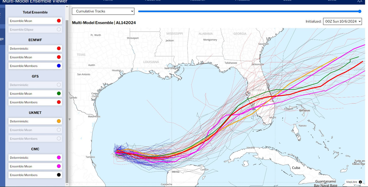
Yes for sure.. here is the gfs mean.

1 likes
-
SFLcane
- S2K Supporter
- Posts: 10281
- Age: 48
- Joined: Sat Jun 05, 2010 1:44 pm
- Location: Lake Worth Florida
Re: ATL: MILTON - Models
Last edited by SFLcane on Sun Oct 06, 2024 4:36 am, edited 1 time in total.
0 likes
-
jlauderdal
- S2K Supporter
- Posts: 7240
- Joined: Wed May 19, 2004 5:46 am
- Location: NE Fort Lauderdale
- Contact:
Re: ATL: MILTON - Models
SFLcane wrote:AtlanticWind wrote:00z models generally came in a little south tonight
See if it’s a trend or not on Sunday
Yes for sure.. here is the gfs mean.
https://i.postimg.cc/sX1bTTh6/IMG-9562.png
Looking ICONish, will see how it goes today but these gulf systems want to go right, we said it with Francine and Helene. NHC has been consistent with mentioning the error rates in their discos, sarasota to homosassa seems like a good bet right now. Pay attention to evacuation zones, we have a problem in this country with people that should evacuate that dont and vice versa. Dont try and fight surge, its a loser. A surge is far different than major hurricane winds.
3 likes
-
eastcoastFL

- Category 5

- Posts: 3996
- Age: 44
- Joined: Thu Apr 12, 2007 12:29 pm
- Location: Palm City, FL
Re: ATL: MILTON - Models
Blown Away wrote:[url]https://i.postimg.cc/y880VV07/IMG-0531.jpg [/url]
00z EURO… Decent S shift, now coming in S of Tampa compared to 12z…
That would be good news if it played out. The southern solution all look weaker.
2 likes
Personal Forecast Disclaimer:
The posts in this forum are NOT official forecast and should not be used as such. They are just the opinion of the poster and may or may not be backed by sound meteorological data. They are NOT endorsed by any professional institution or storm2k.org. For official information, please refer to the NHC and NWS products.
The posts in this forum are NOT official forecast and should not be used as such. They are just the opinion of the poster and may or may not be backed by sound meteorological data. They are NOT endorsed by any professional institution or storm2k.org. For official information, please refer to the NHC and NWS products.

Re: ATL: MILTON - Models
chaser1 wrote:I see how some of the globals seem to want to bring "Milt" in what looks more like Sarasota. Honestly, at this point and given present structural genesis still occurring I wouldn't sweat too much over the small north and south model track wiggles. I'm not at all saying that it ultimately doesn't make a difference where landfall occurs. I'm just saying that unless we're talking most models suddenly shifting way south or north, than I wouldn't look too deep into small shifts quite yet as models may still be struggling with initialization, forward speed, and other variables still to be determined.
Surge is likely to be catastrophic regardless of small changes in track and intensity just prior to landfall. None of the 00Z models were initialized north of 23N last run and Milton has picked up strength overnight so the first recon fix should improve initialization of the later model runs today.
There are hints of a deeper trough moving east over Baha Cali that might be the shear provider models are relying on for the later part of the forecast.
0 likes
-
SFLcane
- S2K Supporter
- Posts: 10281
- Age: 48
- Joined: Sat Jun 05, 2010 1:44 pm
- Location: Lake Worth Florida
Re: ATL: MILTON - Models
jlauderdal wrote:SFLcane wrote:AtlanticWind wrote:00z models generally came in a little south tonight
See if it’s a trend or not on Sunday
Yes for sure.. here is the gfs mean.
https://i.postimg.cc/sX1bTTh6/IMG-9562.png
Looking ICONish, will see how it goes today but these gulf systems want to go right, we said it with Francine and Helene. NHC has been consistent with mentioning the error rates in their discos, sarasota to homosassa seems like a good bet right now. Pay attention to evacuation zones, we have a problem in this country with people that should evacuate that dont and vice versa. Dont try and fight surge, its a loser. A surge is far different than major hurricane winds.
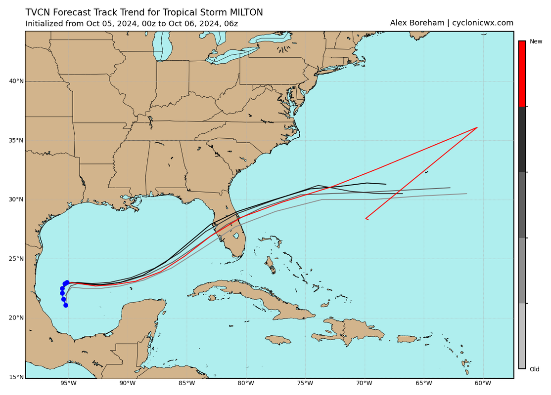
Check this out TCVN "consensus model" essentially nhc's track is back down south. Hope that trend stops.
2 likes
-
cycloneye

- Admin

- Posts: 148835
- Age: 69
- Joined: Thu Oct 10, 2002 10:54 am
- Location: San Juan, Puerto Rico
Re: ATL: MILTON - Models
There will be plenty of recon today and the data will feed to the models that will be better.
1 likes
Visit the Caribbean-Central America Weather Thread where you can find at first post web cams,radars
and observations from Caribbean basin members Click Here
and observations from Caribbean basin members Click Here
-
jlauderdal
- S2K Supporter
- Posts: 7240
- Joined: Wed May 19, 2004 5:46 am
- Location: NE Fort Lauderdale
- Contact:
Re: ATL: MILTON - Models
SFLcane wrote:jlauderdal wrote:
Looking ICONish, will see how it goes today but these gulf systems want to go right, we said it with Francine and Helene. NHC has been consistent with mentioning the error rates in their discos, sarasota to homosassa seems like a good bet right now. Pay attention to evacuation zones, we have a problem in this country with people that should evacuate that dont and vice versa. Dont try and fight surge, its a loser. A surge is far different than major hurricane winds.
Check this out TCVN "consensus model" essentially nhc's track is back down south. Hope that trend stops.
https://i.postimg.cc/rpgK1w1G/BBB.png
They are TCVN huggers for good reason, they will nudge south at 11 as long as the tcvn is doing the same.
0 likes
-
StormPyrate
- Category 1

- Posts: 286
- Joined: Sun May 27, 2018 8:41 pm
- Location: Clearwater, FL
Re: ATL: MILTON - Models
06 Z Icon clinging on to that south track
Waiting on GFS
Waiting on GFS
0 likes
St Petersburg Florida
-
SFLcane
- S2K Supporter
- Posts: 10281
- Age: 48
- Joined: Sat Jun 05, 2010 1:44 pm
- Location: Lake Worth Florida
Re: ATL: MILTON - Models
jlauderdal wrote:SFLcane wrote:jlauderdal wrote:Looking ICONish, will see how it goes today but these gulf systems want to go right, we said it with Francine and Helene. NHC has been consistent with mentioning the error rates in their discos, sarasota to homosassa seems like a good bet right now. Pay attention to evacuation zones, we have a problem in this country with people that should evacuate that dont and vice versa. Dont try and fight surge, its a loser. A surge is far different than major hurricane winds.
Check this out TCVN "consensus model" essentially nhc's track is back down south. Hope that trend stops.
https://i.postimg.cc/rpgK1w1G/BBB.png
They are TCVN huggers for good reason, they will nudge south at 11 as long as the tcvn is doing the same.
3 likes
-
jlauderdal
- S2K Supporter
- Posts: 7240
- Joined: Wed May 19, 2004 5:46 am
- Location: NE Fort Lauderdale
- Contact:
Re: ATL: MILTON - Models
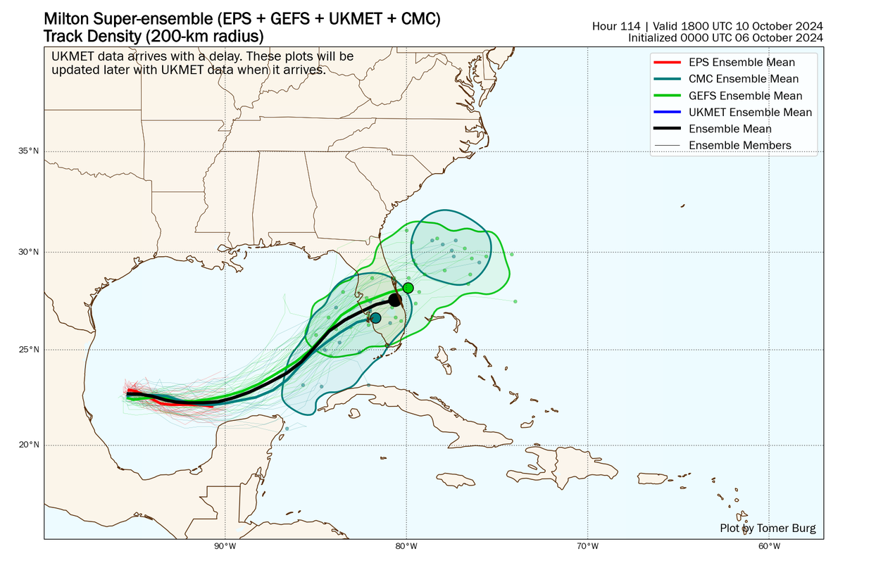
SFLcane wrote:jlauderdal wrote:SFLcane wrote:
Check this out TCVN "consensus model" essentially nhc's track is back down south. Hope that trend stops.
https://i.postimg.cc/rpgK1w1G/BBB.png
They are TCVN huggers for good reason, they will nudge south at 11 as long as the tcvn is doing the same.
https://i.postimg.cc/wjr6gRQG/nnn.png
The model fight isnt going away today-this setup is far more complex than helene , need to continue to look at the means and consensus but the north trend has flipped for now.
4 likes
-
eastcoastFL
- Category 5
- Posts: 3996
- Age: 44
- Joined: Thu Apr 12, 2007 12:29 pm
- Location: Palm City, FL
Re: ATL: MILTON - Models
Milton looks tiny for now but most models seem to expand the storm in overall size once he gets in close proximity to the trough. That will be interesting to see how it plays out.
0 likes
Personal Forecast Disclaimer:
The posts in this forum are NOT official forecast and should not be used as such. They are just the opinion of the poster and may or may not be backed by sound meteorological data. They are NOT endorsed by any professional institution or storm2k.org. For official information, please refer to the NHC and NWS products.
The posts in this forum are NOT official forecast and should not be used as such. They are just the opinion of the poster and may or may not be backed by sound meteorological data. They are NOT endorsed by any professional institution or storm2k.org. For official information, please refer to the NHC and NWS products.
-
eastcoastFL
- Category 5
- Posts: 3996
- Age: 44
- Joined: Thu Apr 12, 2007 12:29 pm
- Location: Palm City, FL
Re: ATL: MILTON - Models
jlauderdal wrote:SFLcane wrote:jlauderdal wrote:They are TCVN huggers for good reason, they will nudge south at 11 as long as the tcvn is doing the same.
https://i.postimg.cc/wjr6gRQG/nnn.png
The model fight isnt going away today-this setup is far more complex than helene , need to continue to look at the means and consensus but the north trend has flipped for now.
I’m hoping that flip to the south I indicative of a weaker storm. Euro comes in south of Tampa as a 60kt storm.
2 likes
Personal Forecast Disclaimer:
The posts in this forum are NOT official forecast and should not be used as such. They are just the opinion of the poster and may or may not be backed by sound meteorological data. They are NOT endorsed by any professional institution or storm2k.org. For official information, please refer to the NHC and NWS products.
The posts in this forum are NOT official forecast and should not be used as such. They are just the opinion of the poster and may or may not be backed by sound meteorological data. They are NOT endorsed by any professional institution or storm2k.org. For official information, please refer to the NHC and NWS products.

Who is online
Users browsing this forum: No registered users and 46 guests