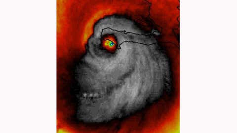
ATL: MILTON - Post-Tropical - Discussion

Moderator: S2k Moderators

Message
Author
USTropics
Professional-Met
Professional-Met
Posts: 2659
Joined: Sun Aug 12, 2007 3:45 am
Location: Florida State University

Re: ATL: MILTON - Hurricane - Discussion: 165 mph / 902 mbs

#3921 Postby USTropics » Tue Oct 08, 2024 9:13 pm

NotoSans wrote:
Travorum wrote:A consistent thing I've noticed with rapidly/explosively intensifying hurricanes recently is SFMR readings are almost always higher than FL wind reduction estimates. This data characteristic has been seen in a lot of recent examples of RI hurricanes; Beryl and Lee come to mind as very recent examples. There are two likely explanations for this: the SFMR wind estimation algorithm is inaccurate at extremely high wind speeds, or winds mix down to the surface more efficiently in rapidly/explosively intensifying hurricanes and the standard FL wind reduction factor is misrepresentative. Either way, I expect that this will be an active area of research in the coming years.

It was similar research into how FL winds correlate to surface winds in 2004 that justified hurricane Andrew's post hoc Cat 5 upgrade a decade after it occurred. Perhaps analysis in the future might examine if standard FL wind reduction factors are universally applicable in RI/EI cases. Conversely, there may be research that corrects the algorithm that defines the relation between SFMR brightness temperature and surface windspeed for the high-end situations. Regardless, this may be an active area of research similar to the research advancements that were occurring in the early 2000s.

If any meteorologists have any insight into this that I am ignorant of, it would be greatly appreciated. This is just my inexpert opinion.


https://twitter.com/WxTca/status/1841103250105516208

SFMR data on NOAA hurricane hunters have been deemed unreliable and therefore not transmitted. Not sure if the same can be applied to AF hurricane hunters.

In any event, NHC has been increasingly sceptical of SFMR performance in higher wind speeds in recent years.


Yes, this is for all SFMR data, NOAA will not be using the data for operational purposes in 2024 due to calibration issues (basically they discovered the instruments were not properly calibrated initially). There is a research group and some students at FSU validating it now, take home being they said it's good up to about 80 m/s but can't be validated after that wind speed.
1 likes   

Fancy1002
Tropical Storm
Tropical Storm
Posts: 140
Joined: Sun Dec 25, 2022 3:47 pm

Re: ATL: MILTON - Hurricane - Discussion: 165 mph / 902 mbs

#3922 Postby Fancy1002 » Tue Oct 08, 2024 9:15 pm

ScottNAtlanta wrote:
Fancy1002 wrote:On IR, it looks like it’s getting a bit ragged and winding down.

I just snapped that WV loop about 10 mins ago...looks fairly healthy to me currently

I’m referring to the almost symetrical Dome shape of the inner section becoming a bit ragged, not the eye area.
0 likes   

User avatar
Category5Kaiju
Category 5
Category 5
Posts: 4107
Joined: Thu Dec 24, 2020 12:45 pm
Location: Seattle

Re: ATL: MILTON - Hurricane - Discussion: 165 mph / 902 mbs

#3923 Postby Category5Kaiju » Tue Oct 08, 2024 9:16 pm

USTropics wrote:
NotoSans wrote:
Travorum wrote:A consistent thing I've noticed with rapidly/explosively intensifying hurricanes recently is SFMR readings are almost always higher than FL wind reduction estimates. This data characteristic has been seen in a lot of recent examples of RI hurricanes; Beryl and Lee come to mind as very recent examples. There are two likely explanations for this: the SFMR wind estimation algorithm is inaccurate at extremely high wind speeds, or winds mix down to the surface more efficiently in rapidly/explosively intensifying hurricanes and the standard FL wind reduction factor is misrepresentative. Either way, I expect that this will be an active area of research in the coming years.

It was similar research into how FL winds correlate to surface winds in 2004 that justified hurricane Andrew's post hoc Cat 5 upgrade a decade after it occurred. Perhaps analysis in the future might examine if standard FL wind reduction factors are universally applicable in RI/EI cases. Conversely, there may be research that corrects the algorithm that defines the relation between SFMR brightness temperature and surface windspeed for the high-end situations. Regardless, this may be an active area of research similar to the research advancements that were occurring in the early 2000s.

If any meteorologists have any insight into this that I am ignorant of, it would be greatly appreciated. This is just my inexpert opinion.


https://twitter.com/WxTca/status/1841103250105516208

SFMR data on NOAA hurricane hunters have been deemed unreliable and therefore not transmitted. Not sure if the same can be applied to AF hurricane hunters.

In any event, NHC has been increasingly sceptical of SFMR performance in higher wind speeds in recent years.


Yes, this is for all SFMR data, NOAA will not be using the data for operational purposes in 2024 due to calibration issues (basically they discovered the instruments were not properly calibrated initially). There is a research group and some students at FSU validating it now, take home being they said it's good up to about 80 m/s but can't be validated after that wind speed.


Wait, was SFMR data the reason why Iota was operationally a Category 5 at first? Back in 2020
0 likes   
Unless explicitly stated, all info in my posts is based on my own opinions and observations. Tropical storms and hurricanes can be extremely dangerous. Do not think you can beat Mother Nature. Refer to an accredited weather research agency or meteorologist if you need to make serious decisions regarding an approaching storm.

wx98
Category 5
Category 5
Posts: 1383
Joined: Sat Aug 25, 2018 9:24 pm

Re: ATL: MILTON - Hurricane - Discussion: 165 mph / 902 mbs

#3924 Postby wx98 » Tue Oct 08, 2024 9:16 pm

May be seeing a slight reduction in intensity at the next update, in line with latest recon data and satellite trends. If this tracks south of Tampa Bay, there’ll be a radically different surge scenario, with the bay actually emptying (like with Ian). The bay side of St Petersburg and Clearwater could still have surge issues with offshore wind. Still well within the margin of error for track, but things are definitely trending south today. If trends hold, look for NHC to start to lower surge forecasts slightly for the bay and northward.
0 likes   

FLLurker32
Tropical Storm
Tropical Storm
Posts: 245
Joined: Mon Aug 29, 2016 10:31 am

Re: ATL: MILTON - Hurricane - Discussion: 165 mph / 902 mbs

#3925 Postby FLLurker32 » Tue Oct 08, 2024 9:18 pm

Meteorcane wrote:
FLLurker32 wrote:I had to go back and look for my own sanity check.

NHC cone for Helene 24 hours prior to landfall did not even include the county where landfall ultimately occurred. The guidance models were in FAR better agreement then than they are now - and had been for a couple days - and were all wrong.

Milton has been even less predictable. Lest anyone get too comfortable of what they think they know..


this is factually not correct... the landfall point was a bit on the right side of the 24 hour cone, but it was within it... refer to https://www.nhc.noaa.gov/archive/2024/HELENE_graphics.php?product=5day_cone_no_line_and_wind

But... I will edit this post to emphasize that your basic point is correct, overly focusing on the track centerline is not wise as is living and dying with each model cycle and/or wobble (although wobble watching does become relevant shortly before landfall).


I understand that it landed in the far Eastern side of the final cone prior to landfall, that’s not what I’m referring to. If you start at advisory 11 on 9/25 and each subsequent advisory through the morning of 9/26 you will see that the ultimate landfall point went in and out of the most extreme eastern corner of the cone. Even more notable, the direction of entry changed drastically within those 24 hours, giving Eastern GA quite the surprise.

The point: We’ve come a long way in predicting hurricanes, but no one should be getting cocky because we still have a very long way to go. No one here within a warning or watch area should think they’re magically safe because “user12345” said so.
2 likes   
Heather

User avatar
ScottNAtlanta
Category 5
Category 5
Posts: 2379
Joined: Sat May 25, 2013 3:11 pm
Location: Atlanta, GA

Re: ATL: MILTON - Hurricane - Discussion: 165 mph / 902 mbs

#3926 Postby ScottNAtlanta » Tue Oct 08, 2024 9:18 pm

Steve wrote:As plenty of people have mentioned weakening is relative. Yeah it’s better to get a 940’s system than a 920’s or lower. But don’t think for a that won’t be a historic storm for those who have to deal with it. Hurricane Betsy 1965 came in Grand Isle at 946. It was the benchmark storm in New Orleans for my parents generation (I was too young to remember) and was the big storm until Katrina hit. Milton could conceivably still hit in the 930’s which is worse. Gonna be tens of billions in damage across the state, and lives will be lost. Regardless of whether it goes in Tampa Bay or south, millions will still be affected. Sarasota-Bradenton has over 800k people and close to 900k if you consider down toward Venice. Orlando has over 2.5MM population and there is another 600k in Titusville/Melbourne/Mims/Cocoa Beach. Plus there’s a lot of people in between those statistical areas. This isn’t a big bend type storm or Panhandle hit because of the number of people that will be affected. It’s gonna be ugly maybe in ways we haven’t seen yet.

Just to expand on that...the biggest thing to fear in this storm will be water. The surge is not really something that fluctuates as winds fluctuate. It builds as it goes, and if the winds do die down before landfall that's not going to reduce the surge one bit. Katrina surprised a lot of people with how high the surge was even though it was weakening pretty quickly at landfall. Don't be lulled into thinking that a wind reduction will mean a less severe storm. The deadliest part of this storm (and most hurricanes) is water
3 likes   
The posts in this forum are NOT official forecast and should not be used as such. They are just the opinion of the poster and may or may not be backed by sound meteorological data. They are NOT endorsed by any professional institution or storm2k.org. For official information, please refer to the NHC and NWS products.

tolakram
Admin
Admin
Posts: 20012
Age: 62
Joined: Sun Aug 27, 2006 8:23 pm
Location: Florence, KY (name is Mark)

Re: ATL: MILTON - Hurricane - Discussion: 165 mph / 902 mbs

#3927 Postby tolakram » Tue Oct 08, 2024 9:18 pm

I think Milton has gotten a bit smaller.

The full Milton
Image
21 likes   
M a r k
- - - - -
Join us in chat: Storm2K Chatroom Invite. Android and IOS apps also available.

The posts in this forum are NOT official forecasts and should not be used as such. Posts are NOT endorsed by any professional institution or STORM2K.org. For official information and forecasts, please refer to NHC and NWS products.

Ken711
Category 5
Category 5
Posts: 1074
Joined: Tue Aug 28, 2012 12:48 pm

Re: ATL: MILTON - Hurricane - Discussion: 165 mph / 902 mbs

#3928 Postby Ken711 » Tue Oct 08, 2024 9:22 pm

tolakram wrote:I think Milton has gotten a bit smaller.

The full Milton
https://i.imgur.com/q2LB7qM.gif


Small buzz saw.
0 likes   

gailwarning
S2K Supporter
S2K Supporter
Posts: 57
Joined: Sun Sep 10, 2017 1:09 pm
Location: N. Georgia. Sick of FL

Re: ATL: MILTON - Hurricane - Discussion: 165 mph / 902 mbs

#3929 Postby gailwarning » Tue Oct 08, 2024 9:22 pm

tiger_deF wrote:The good news throughout this is that (even with the predicted expansion of wind radius) Milton is a small system. It could conceivably thread the needle between Sarasota and Fort Meyers, or maybe even Tampa and Sarasota. Of course all places would still receive hurricane force winds and potentially life threatening surge, but the damage corridor would be minimized.

A storm like Katrina at this heading would bring 20-30+ feet of surge over the entire region, and major hurricane impacts across the most populated corridor in Florida, and be a true catastrophe. Milton will be disastrous but more localized, like an Anti-Helene.


Will the EWRC that may be underway cause the size of the storm to increase?
0 likes   

User avatar
ScottNAtlanta
Category 5
Category 5
Posts: 2379
Joined: Sat May 25, 2013 3:11 pm
Location: Atlanta, GA

Re: ATL: MILTON - Hurricane - Discussion: 165 mph / 902 mbs

#3930 Postby ScottNAtlanta » Tue Oct 08, 2024 9:22 pm

tolakram wrote:I think Milton has gotten a bit smaller.

The full Milton
https://i.imgur.com/q2LB7qM.gif

Looks like it has contracted in.
0 likes   
The posts in this forum are NOT official forecast and should not be used as such. They are just the opinion of the poster and may or may not be backed by sound meteorological data. They are NOT endorsed by any professional institution or storm2k.org. For official information, please refer to the NHC and NWS products.

User avatar
MississippiWx
S2K Supporter
S2K Supporter
Posts: 1699
Joined: Sat Aug 14, 2010 1:44 pm
Location: Hattiesburg, Mississippi

Re: ATL: MILTON - Hurricane - Discussion: 165 mph / 902 mbs

#3931 Postby MississippiWx » Tue Oct 08, 2024 9:22 pm

Creepy face returns. :double:

Image
12 likes   
This post is not an official forecast and should not be used as such. It is just the opinion of MississippiWx and may or may not be backed by sound meteorological data. It is not endorsed by any professional institution including storm2k.org. For Official Information please refer to the NHC and NWS products.

User avatar
Steve
S2K Supporter
S2K Supporter
Posts: 9623
Joined: Sat Apr 05, 2003 11:41 pm
Location: Not a state-caster

Re: ATL: MILTON - Hurricane - Discussion: 165 mph / 902 mbs

#3932 Postby Steve » Tue Oct 08, 2024 9:23 pm

ScottNAtlanta wrote:
Steve wrote:As plenty of people have mentioned weakening is relative. Yeah it’s better to get a 940’s system than a 920’s or lower. But don’t think for a that won’t be a historic storm for those who have to deal with it. Hurricane Betsy 1965 came in Grand Isle at 946. It was the benchmark storm in New Orleans for my parents generation (I was too young to remember) and was the big storm until Katrina hit. Milton could conceivably still hit in the 930’s which is worse. Gonna be tens of billions in damage across the state, and lives will be lost. Regardless of whether it goes in Tampa Bay or south, millions will still be affected. Sarasota-Bradenton has over 800k people and close to 900k if you consider down toward Venice. Orlando has over 2.5MM population and there is another 600k in Titusville/Melbourne/Mims/Cocoa Beach. Plus there’s a lot of people in between those statistical areas. This isn’t a big bend type storm or Panhandle hit because of the number of people that will be affected. It’s gonna be ugly maybe in ways we haven’t seen yet.

Just to expand on that...the biggest thing to fear in this storm will be water. The surge is not really something that fluctuates as winds fluctuate. It builds as it goes, and if the winds do die down before landfall that's not going to reduce the surge one bit. Katrina surprised a lot of people with how high the surge was even though it was weakening pretty quickly at landfall. Don't be lulled into thinking that a wind reduction will mean a less severe storm. The deadliest part of this storm (and most hurricanes) is water


100. We were talking about it Saturday or Sunday. The dome of water (surge) is coming regardless of how much the pressure rises or the winds relax.
Last edited by Steve on Tue Oct 08, 2024 9:24 pm, edited 1 time in total.
0 likes   

Sciencerocks
Category 5
Category 5
Posts: 9160
Age: 39
Joined: Thu Jul 06, 2017 1:51 am

Re: ATL: MILTON - Hurricane - Discussion: 165 mph / 902 mbs

#3933 Postby Sciencerocks » Tue Oct 08, 2024 9:23 pm

Image
6 likes   

USTropics
Professional-Met
Professional-Met
Posts: 2659
Joined: Sun Aug 12, 2007 3:45 am
Location: Florida State University

Re: ATL: MILTON - Hurricane - Discussion: 165 mph / 902 mbs

#3934 Postby USTropics » Tue Oct 08, 2024 9:24 pm

Category5Kaiju wrote:
USTropics wrote:
NotoSans wrote:
https://twitter.com/WxTca/status/1841103250105516208

SFMR data on NOAA hurricane hunters have been deemed unreliable and therefore not transmitted. Not sure if the same can be applied to AF hurricane hunters.

In any event, NHC has been increasingly sceptical of SFMR performance in higher wind speeds in recent years.


Yes, this is for all SFMR data, NOAA will not be using the data for operational purposes in 2024 due to calibration issues (basically they discovered the instruments were not properly calibrated initially). There is a research group and some students at FSU validating it now, take home being they said it's good up to about 80 m/s but can't be validated after that wind speed.


Wait, was SFMR data the reason why Iota was operationally a Category 5 at first? Back in 2020


It absolutely was, and was the reason for the downgrade (it was assessed at operational flight level winds with the 90% rule for reduction to surface applied). It's particularly suspect when shoaling is involved (like near an island or landmass, as Iota was and Milton). From the reanalysis of Iota by Stacy Stewart: "ongoing research suggests there is a high bias of SFMR wind speeds in these high wind regimes.”
0 likes   

User avatar
ElectricStorm
Category 5
Category 5
Posts: 5057
Age: 24
Joined: Tue Aug 13, 2019 11:23 pm
Location: Skiatook, OK / Norman, OK

Re: ATL: MILTON - Hurricane - Discussion: 165 mph / 902 mbs

#3935 Postby ElectricStorm » Tue Oct 08, 2024 9:24 pm

Eye drop supports 915mb
0 likes   
B.S Meteorology, University of Oklahoma '25

Please refer to the NHC, NWS, or SPC for official information.

Hurricane Mike
Category 2
Category 2
Posts: 644
Joined: Tue Apr 10, 2018 7:44 am

Re: ATL: MILTON - Hurricane - Discussion: 165 mph / 902 mbs

#3936 Postby Hurricane Mike » Tue Oct 08, 2024 9:24 pm

I am surprised how small Milton still is, I wonder if that could maybe lessen the extent of the storm surge if it doesn't expand the wind field much in the next 24 hours.
1 likes   

User avatar
ScottNAtlanta
Category 5
Category 5
Posts: 2379
Joined: Sat May 25, 2013 3:11 pm
Location: Atlanta, GA

Re: ATL: MILTON - Hurricane - Discussion: 165 mph / 902 mbs

#3937 Postby ScottNAtlanta » Tue Oct 08, 2024 9:26 pm

Latest pass through the eye has it at 6nm and 916mb. No mention of concentric rings as of now
0 likes   
The posts in this forum are NOT official forecast and should not be used as such. They are just the opinion of the poster and may or may not be backed by sound meteorological data. They are NOT endorsed by any professional institution or storm2k.org. For official information, please refer to the NHC and NWS products.

User avatar
Kazmit
Category 5
Category 5
Posts: 2125
Age: 22
Joined: Mon Jul 25, 2016 8:49 am
Location: Williamsburg, VA / Bermuda

Re: ATL: MILTON - Hurricane - Discussion: 165 mph / 902 mbs

#3938 Postby Kazmit » Tue Oct 08, 2024 9:28 pm

MississippiWx wrote:Creepy face returns. :double:

[url]https://i.ibb.co/y5h7NYs/IMG-4363.jpg [/url]

Close enough, welcome back Hurricane Matthew.

Image
6 likes   
Igor 2010, Sandy 2012, Fay 2014, Gonzalo 2014, Joaquin 2015, Nicole 2016, Humberto 2019

I am only a tropical weather enthusiast. My predictions are not official and may or may not be backed by sound meteorological data. For official information, please refer to the NHC and NWS products.

psyclone
S2K Supporter
S2K Supporter
Posts: 4769
Joined: Wed Aug 24, 2005 9:04 pm
Location: palm harbor fl

Re: ATL: MILTON - Hurricane - Discussion: 165 mph / 902 mbs

#3939 Postby psyclone » Tue Oct 08, 2024 9:29 pm

wx98 wrote:May be seeing a slight reduction in intensity at the next update, in line with latest recon data and satellite trends. If this tracks south of Tampa Bay, there’ll be a radically different surge scenario, with the bay actually emptying (like with Ian). The bay side of St Petersburg and Clearwater could still have surge issues with offshore wind. Still well within the margin of error for track, but things are definitely trending south today. If trends hold, look for NHC to start to lower surge forecasts slightly for the bay and northward.


Do you expect another southward adjustment at 11?
0 likes   

User avatar
Hypercane_Kyle
Category 5
Category 5
Posts: 3355
Joined: Sat Mar 07, 2015 7:58 pm
Location: Cape Canaveral, FL

Re: ATL: MILTON - Hurricane - Discussion: 165 mph / 902 mbs

#3940 Postby Hypercane_Kyle » Tue Oct 08, 2024 9:31 pm


I've noticed Milton isn't really letting go of having a ton of lightning in its core. I wonder if the MSLP rise we are seeing is more-so due to expanding size as it interacts with the jet stream vs an EWRC. Visually it still looks impressive.
6 likes   
My posts are my own personal opinion, defer to the National Hurricane Center (NHC) and other NOAA products for decision making during hurricane season.


Return to “2024”

Who is online

Users browsing this forum: No registered users and 3 guests