Is there a graphic at that scale that shows the predicted winds?
ATL: MILTON - Models
Moderator: S2k Moderators
-
otowntiger
- Category 5

- Posts: 1932
- Joined: Tue Aug 31, 2004 7:06 pm
Re: ATL: INVEST 92L - Models
Is there a graphic at that scale that shows the predicted winds?
0 likes
-
weeniepatrol

- Category 5
- Posts: 1342
- Joined: Sat Aug 22, 2020 5:30 pm
- Location: WA State


Re: ATL: INVEST 92L - Models
Very interesting how the majority of the models have landfall around Wednesday morning and the CMC has been the only one to say Friday landfall. I wonder what the model is seeing that the others aren’t
Last edited by caneseddy on Fri Oct 04, 2024 11:29 pm, edited 1 time in total.
2 likes
-
weeniepatrol
- Category 5
- Posts: 1342
- Joined: Sat Aug 22, 2020 5:30 pm
- Location: WA State
Re: ATL: INVEST 92L - Models
Just your usual 40mb run-to-run variance.
Within 3 days btw
Edit: four* days
Last edited by weeniepatrol on Sat Oct 05, 2024 12:07 am, edited 1 time in total.
5 likes
-
StPeteMike

- Category 2

- Posts: 653
- Joined: Thu Jun 07, 2018 11:26 pm
Re: ATL: INVEST 92L - Models
Looks like the difference is the ridging behind the trough. ICON and Canadian says the ridge builds in pretty quick behind the trough and pushes Milton further south while GFS says it takes a little longer for the ridge to build in.
0 likes
The above post is not official and should not be used as such. It is the opinion of the poster and may or may not be backed by sound meteorological data. It is not endorsed by any professional institution or storm2k.org. For official information, please refer to the NHC and NWS products.


Re: ATL: INVEST 92L - Models
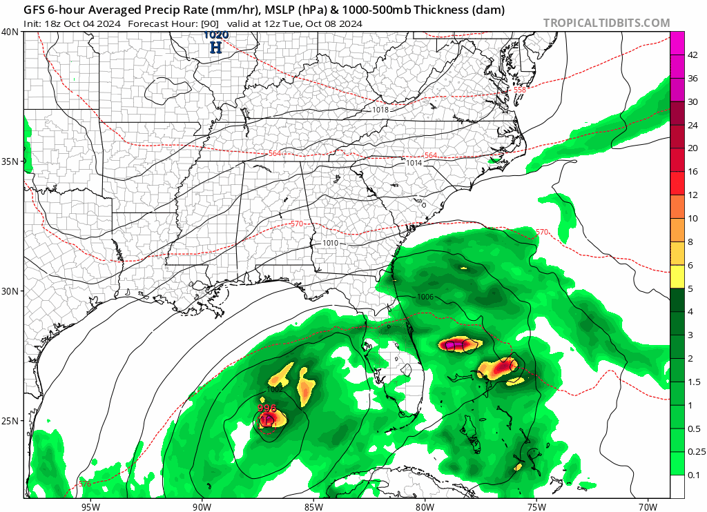
All these wild swings from the GFS today,cannot be trusted at this time.
3 likes


Re: ATL: INVEST 92L - Models
Just about the worst case for a catastrophic storm surge event in Tampa
0 likes
-
otowntiger
- Category 5
- Posts: 1932
- Joined: Tue Aug 31, 2004 7:06 pm
Re: ATL: INVEST 92L - Models
Yeah, GFS has been pretty inconsistent- next run could very well be way different- could be back to a weak TD in a whole new location, who knows?
5 likes

Re: ATL: INVEST 92L - Models
I could tell a bonkers run before even seeing the comments or checking the runs, when I saw that 1.5 pages of comments had been made in 1 hour.
5 likes
TC naming lists: retirements and intensity
Most aggressive Advisory #1's in North Atlantic (cr. kevin for starting the list)
Most aggressive Advisory #1's in North Atlantic (cr. kevin for starting the list)
-
Flwxguy86

- Tropical Depression

- Posts: 51
- Age: 39
- Joined: Sun Sep 15, 2024 11:06 am
- Location: Oldsmar,FL
Re: ATL: INVEST 92L - Models
I really hope the GFS is just spitting this out and comes back down to earth tomorrow, Not only is Tampa still cleaning up from Helene, but we are not prepared for this kinda storm, Nobody is but especially Tampa/Pinellas county. I am actually in Pinellas county right at the top of Tampa bay in Oldsmar, This would be a worst case scenario for me personally, All that water would head this direction and also towards safety harbor. Who knows though, We haven't seen a major hurricane, not even really a direct hit since 1921. That streak has to end some day, I just hope it isn't as a cat 4 or 5. We'd probably honestly be pretty screwed with a 3 if I am being completely honest.
4 likes

Re: ATL: INVEST 92L - Models
I guess no NHC tropical models were run tonight, they should had been coming out by now.
0 likes
Re: ATL: INVEST 92L - Models
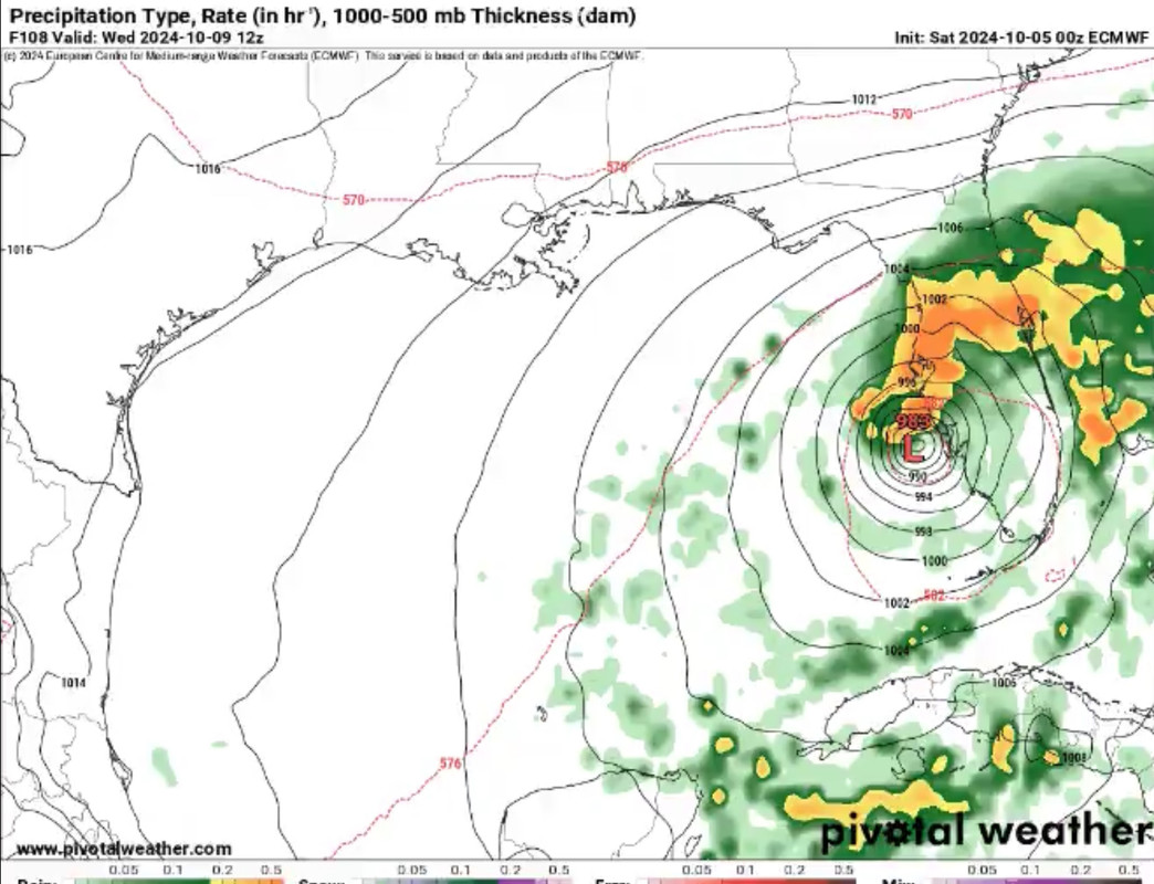
SFLcane wrote:https://i.postimg.cc/2SrWq1h8/IMG-1577.jpg
How did you get that so early, I’m still at 48 hours on tropical tidbits for the fast version
0 likes
Re: ATL: INVEST 92L - Models
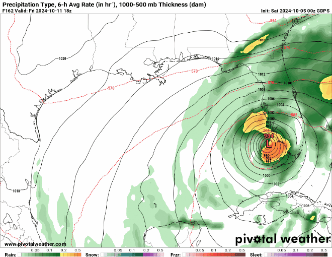
00z runs tonight:
GFS: Tampa Bay Wednesday morning
Euro: Fort Myers Wednesday morning
CMC: Naples Friday morning
Icon: Naples Wednesday morning
Let’s see what 6z shows. Hard to bet against Icon with its performance so far in the Gulf but we will see. Not buying the GFS bomb that far north yet. The positive in this is that it will be quick mover where by Wednesday night it’s already crossed the state to the Atlantic
1 likes
Re: ATL: INVEST 92L - Models
SFLcane wrote:Don’t think your getting a major in 2-3 days or whatever the gfs is showing there. That looks silly.
Agree!
While not impossible, I don't see an almost-Cat4 hitting Tampa in 96-ish/108 hours! NHC isn't even hinting at a Hurricane and we are within their famous 5 day cone. I think the GFS is smoking crack with these runs.
0 likes
-
AxaltaRacing24
- Category 5
- Posts: 1774
- Age: 25
- Joined: Wed Jul 27, 2016 11:14 am
- Location: Jupiter, FL
Re: ATL: INVEST 92L - Models
NFLnut wrote:SFLcane wrote:Don’t think your getting a major in 2-3 days or whatever the gfs is showing there. That looks silly.
Agree!
While not impossible, I don't see an almost-Cat4 hitting Tampa in 96-ish/108 hours! NHC isn't even hinting at a Hurricane and we are within their famous 5 day cone. I think the GFS is smoking crack with these runs.
In an era where RI is becoming more and more common, no point in just ruling these scenarios out before the storm even forms. We even have ensembles backing this up as well. Runs like that one are a reminder to prepare for the worst but hope for the best. Helene was a lesson, use it.
6 likes
Who is online
Users browsing this forum: No registered users and 5 guests