ATL: SARA - Models
Moderator: S2k Moderators
-
Hypercane_Kyle

- Category 5

- Posts: 3465
- Joined: Sat Mar 07, 2015 7:58 pm
- Location: Cape Canaveral, FL
Re: ATL: INVEST 99L - Models
99L's ultimate strength is tied to how far east/west it consolidates. Seems to me the GFS is mostly an outlier and too far east.
2 likes
My posts are my own personal opinion, defer to the National Hurricane Center (NHC) and other NOAA products for decision making during hurricane season.

Re: ATL: INVEST 99L - Models
Hypercane_Kyle wrote:99L's ultimate strength is tied to how far east/west it consolidates. Seems to me the GFS is mostly an outlier and too far east.
i agree, i think a few minor tweaks would push it right into central america like the euro/cmc shows. regardless, the GFS is relentless in bombing out, moving thru the channel and impacting florida, we'll see if it's right
Last edited by Jxdama on Tue Nov 12, 2024 6:14 pm, edited 1 time in total.
0 likes


Re: ATL: INVEST 99L - Models
Hypercane_Kyle wrote:99L's ultimate strength is tied to how far east/west it consolidates. Seems to me the GFS is mostly an outlier and too far east.
Should GFS continue to be an outlier, tomorrow's recon will provide a good litmus test on which model is more aligned with ground truth. The first flight is scheduled to be on station tomorrow at 1900z, when the GFS has 99L at 1005-1004mb just south of Jamaica and the Euro/CMC have it at >1010mb and little further west. Recon finding a deeper and more closed circulation closer to Jamaica could lend some credence to the GFS solution, finding a broader or shallower or more westward circulation could support a weaker solution into Central America.
5 likes
-
toad strangler

- S2K Supporter

- Posts: 4546
- Joined: Sun Jul 28, 2013 3:09 pm
- Location: Earth
- Contact:
Re: ATL: INVEST 99L - Models
ronjon wrote:Have a hard time believing a 970 mb cane into Cedar Key during 3rd week of November per 18z GFS. Seems S FL to the Keys would be more likely destination given the time of year.
It’s 2024. Throw climatology out the window. No?
3 likes
My Weather Station
https://www.wunderground.com/dashboard/pws/KFLPORTS603
https://www.wunderground.com/dashboard/pws/KFLPORTS603

Re: ATL: INVEST 99L - Models
aspen wrote:Unfortunately it seems like no hurricane model runs this cycle for some reason. Darn.
I wasn't sure they would have run an 18z. model run on such a short fuse. No worries, I'll be happy to check their 0Z cycle
0 likes
Andy D
(For official information, please refer to the NHC and NWS products.)
(For official information, please refer to the NHC and NWS products.)
-
TheAustinMan

- Category 5
- Posts: 1060
- Joined: Mon Jul 08, 2013 4:26 pm
- Location: Central TX / United States
Re: ATL: INVEST 99L - Models
While I can't post a graphic at present since it's only available on paid sites at the moment, the 18z ECMWF has 99L organizing into a tropical depression on about Thursday and keeps it much farther offshore Honduras compared to the 12z rendition. It's a major hurricane in the model Sunday and in the process of recurving northward east of the Yucatan on Monday afternoon on the model. Based on the 947 mb pressure, it's roughly a Category 4 hurricane at that point.
Last edited by TheAustinMan on Tue Nov 12, 2024 6:37 pm, edited 2 times in total.
3 likes
Treat my opinions with a grain of salt. For official information see your local weather service.
“It's tough to make predictions, especially about the future.”
“It's tough to make predictions, especially about the future.”
-
SconnieCane
- Category 5
- Posts: 1013
- Joined: Thu Aug 02, 2018 5:29 pm
- Location: Madison, WI
Re: ATL: INVEST 99L - Models
caneseddy wrote:Shooting the Yucatan Channel into the Gulf at 946 mb..starting the turn towards the Florida Peninsula at 174 hrs...949 mb..looks like Big Bend area is target this run.
Cue John Hurt in his cameo in Spaceballs as the alien starts to burst out of his chest..."Oh no, not again!"
3 likes
Re: ATL: INVEST 99L - Models
Travorum wrote:Hypercane_Kyle wrote:99L's ultimate strength is tied to how far east/west it consolidates. Seems to me the GFS is mostly an outlier and too far east.
Should GFS continue to be an outlier, tomorrow's recon will provide a good litmus test on which model is more aligned with ground truth. The first flight is scheduled to be on station tomorrow at 1900z, when the GFS has 99L at 1005-1004mb just south of Jamaica and the Euro/CMC have it at >1010mb and little further west. Recon finding a deeper and more closed circulation closer to Jamaica could lend some credence to the GFS solution, finding a broader or shallower or more westward circulation could support a weaker solution into Central America.
I have to admit, I think the GFS may be a bit to fast to
consolidate but especially overly fast to reach sub 960 mb. Whether that alone results in a more west motion over time will be interesting to see
0 likes
Andy D
(For official information, please refer to the NHC and NWS products.)
(For official information, please refer to the NHC and NWS products.)
Re: ATL: INVEST 99L - Models
TheAustinMan wrote:While I can't post a graphic at present since it's only available on paid sites at the moment, the 18z ECMWF has 99L organizing into a tropical depression on about Thursday and keeps it much farther offshore Honduras compared to the 12z rendition. It's a major hurricane in the model Sunday and in the process of recurving northward east of the Yucatan on Monday afternoon on the model. Based on the 947 mb pressure, it's roughly a Category 4 hurricane at that point.
Ya 18z is a beast
1 likes
-
SFLcane

- S2K Supporter
- Posts: 10281
- Age: 48
- Joined: Sat Jun 05, 2010 1:44 pm
- Location: Lake Worth Florida
Re: ATL: INVEST 99L - Models
And there goes your land interaction.. personally I’d side any day with the Gefs/eps over an experimental model.
2 likes
Re: ATL: INVEST 99L - Models
00z SHIPS model, not much change from 18z. Still on a knife’s edge with SHIPS on land interaction:

3 likes
-
cycloneye

- Admin

- Posts: 149720
- Age: 69
- Joined: Thu Oct 10, 2002 10:54 am
- Location: San Juan, Puerto Rico
Re: ATL: INVEST 99L - Models


5 likes
Visit the Caribbean-Central America Weather Thread where you can find at first post web cams,radars
and observations from Caribbean basin members Click Here
and observations from Caribbean basin members Click Here
-
Miami Storm Tracker

- Category 4

- Posts: 916
- Age: 68
- Joined: Sun Jun 13, 2010 10:12 pm
- Location: Key Largo, Fla.
- Contact:
Re: ATL: INVEST 99L - Models
Evening
As some are referring the GFS as the outlier and this may be true. But that temporary high presseure that will build over Florida, will be key how far west future Sara gets, before it heads back East or ENE. I still feel uncomfortable that it does not get as far north as some models show. No matter how you look at it, this is not good for any of us in Florida.
As some are referring the GFS as the outlier and this may be true. But that temporary high presseure that will build over Florida, will be key how far west future Sara gets, before it heads back East or ENE. I still feel uncomfortable that it does not get as far north as some models show. No matter how you look at it, this is not good for any of us in Florida.
1 likes


Re: ATL: INVEST 99L - Models
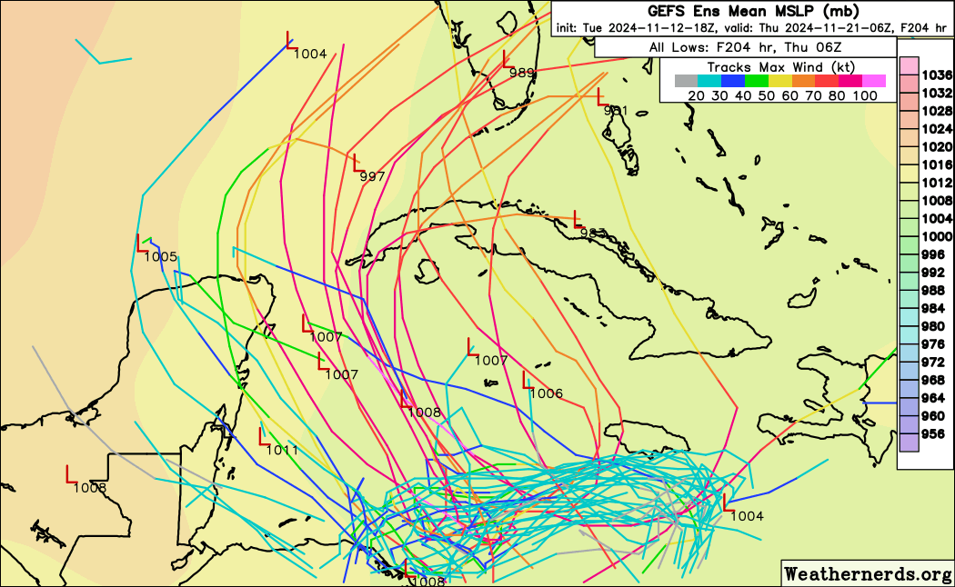
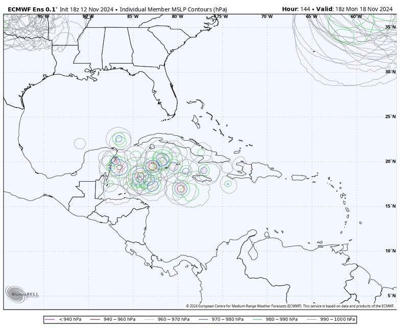
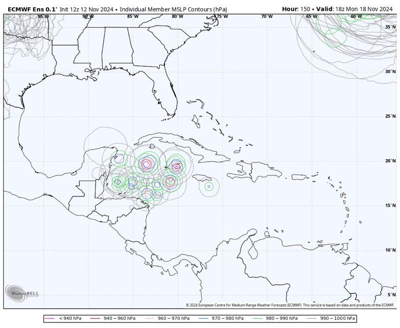
Here are the current Ensemble from the EURO and GFS for next Thursday 0Z(Wednesday night for Florida)
It is looking more likely Florida will get a piece if not a lot more of whatever develops.
GEFS:

EURO:

It is looking more likely Florida will get a piece if not a lot more of whatever develops.
GEFS:
EURO:
2 likes
Re: ATL: INVEST 99L - Models
Take it with a grain of salt as its a private/commercial model and its not clear how well it has verified in the past, but here's the 00z GRAF. It takes 99L further west before stalling but keeps it north of Honduras allowing for intensification; in this regard it seems most in line with ICON and 18z Euro right now. The model doesn't run far enough out but my guess is that going this far west would make land interaction with the Yucatan more likely.
https://x.com/jnelsonWJCL/status/1856527802801287640
https://x.com/jnelsonWJCL/status/1856527802801287640
0 likes
Re: ATL: INVEST 99L - Models
00z Icon landfalls a strong TS/Cat 1 into Belize/Mexico border…crossing Yucatán into GOM..run finishes as a TD heading towards Panhandle
0 likes
Who is online
Users browsing this forum: No registered users and 45 guests