ATL: DEBBY - Post-Tropical - Discussion

Moderator: S2k Moderators

Message
Author
hurricaneCW
Category 5
Category 5
Posts: 1792
Joined: Wed Mar 03, 2010 6:20 am
Location: Toms River, NJ

Re: ATL: FOUR - Tropical Depression - Discussion

#421 Postby hurricaneCW » Sat Aug 03, 2024 7:14 am

Hurrilurker wrote:Looks like a pretty big jump to the NW. That's good because it might not travel over the narrowest, flattest part of PR, and will have less time in the Gulf to organize.


Won't make a difference because it's still so broad and disorganized. If it were a well organized storm then sure.
0 likes   

User avatar
cycloneye
Admin
Admin
Posts: 143879
Age: 68
Joined: Thu Oct 10, 2002 10:54 am
Location: San Juan, Puerto Rico

Re: ATL: FOUR - Tropical Depression - Discussion

#422 Postby cycloneye » Sat Aug 03, 2024 7:19 am

1 likes   
Visit the Caribbean-Central America Weather Thread where you can find at first post web cams,radars
and observations from Caribbean basin members Click Here

User avatar
GCANE
S2K Supporter
S2K Supporter
Posts: 11453
Joined: Mon Oct 22, 2007 8:03 am

Re: ATL: FOUR - Tropical Depression - Discussion

#423 Postby GCANE » Sat Aug 03, 2024 7:25 am

Michele B wrote:I still believe once this system gets out into the Gulf ALL earlier intensity forecasts and future track cones go out the window. It sure is moving slow.

The Bermuda high is strong, but is Four going to miss the dip in the jet stream that’s supposed to pick it up and steer it north/NE?


The bad thing about the trof is that it has a Anti-cyclonic Rossby Wave Break to its SE; i.e. in the East GoM.
Debby could significantly strengthen due to this.
3 likes   

Sciencerocks
Category 5
Category 5
Posts: 8903
Age: 39
Joined: Thu Jul 06, 2017 1:51 am

Re: ATL: FOUR - Tropical Depression - Discussion

#424 Postby Sciencerocks » Sat Aug 03, 2024 7:26 am

Image
1 likes   

User avatar
REDHurricane
Category 1
Category 1
Posts: 395
Age: 27
Joined: Sun Jul 03, 2022 2:36 pm
Location: Northeast Pacific Ocean

Re: ATL: FOUR - Tropical Depression - Discussion

#425 Postby REDHurricane » Sat Aug 03, 2024 7:31 am

It's moving almost due north now, both GFS/Euro have it entering the Gulf around 23.1ºN, 81ºW so I'll be watching that over the next 6-12 hours

Image
2 likes   

hurricaneCW
Category 5
Category 5
Posts: 1792
Joined: Wed Mar 03, 2010 6:20 am
Location: Toms River, NJ

Re: ATL: FOUR - Tropical Depression - Discussion

#426 Postby hurricaneCW » Sat Aug 03, 2024 7:33 am

Shear is so low across the Caribbean & Gulf right now. Scary if that continues this season.

Only thing holding this back is land, SSTs are near record highs
3 likes   

User avatar
cycloneye
Admin
Admin
Posts: 143879
Age: 68
Joined: Thu Oct 10, 2002 10:54 am
Location: San Juan, Puerto Rico

Re: ATL: FOUR - Tropical Depression - Discussion

#427 Postby cycloneye » Sat Aug 03, 2024 7:34 am

12z Best Track:

AL, 04, 2024080312, , BEST, 0, 223N, 815W, 25, 1009, TD


Image
2 likes   
Visit the Caribbean-Central America Weather Thread where you can find at first post web cams,radars
and observations from Caribbean basin members Click Here

User avatar
Jr0d
S2K Supporter
S2K Supporter
Posts: 1394
Joined: Tue Aug 27, 2019 10:52 am
Location: Cayo Hueso

Re: ATL: FOUR - Tropical Depression - Discussion

#428 Postby Jr0d » Sat Aug 03, 2024 7:43 am

Am I seeing this right?

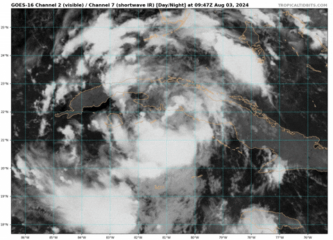
The depression seems to have found the narrowest and fairly flat portion of Cuba to cross, however this is less of an issue with the depression still having a relatively broad low and circulation. It also seems to be moving more northwest now, but that is difficult to tell because how disorganized the center is.

Hoping it continues to stay ragged and underperforms.

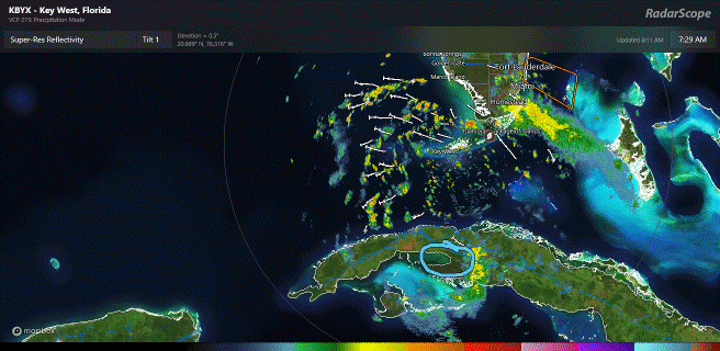
Here in Key West we have sustained winds near 20kts with the sun out, and had gusts near 30kts in the squalls early this morning. It is looking mostly clear on the radar for the next few hours, but I do expect deteriorating conditions by this afternoon as I expect the storm to really start consolidating once it clears Cuba.

Even though we are 'only' under a watch, I do think tropical storm conditions are likely later tonight.
Last edited by Jr0d on Sat Aug 03, 2024 7:45 am, edited 1 time in total.
0 likes   

User avatar
CronkPSU
S2K Supporter
S2K Supporter
Posts: 2014
Joined: Sun Aug 07, 2005 10:44 pm
Location: Avalon Park, FL

Re: ATL: FOUR - Tropical Depression - Discussion

#429 Postby CronkPSU » Sat Aug 03, 2024 7:44 am

cycloneye wrote:12z Best Track:

AL, 04, 2024080312, , BEST, 0, 223N, 815W, 25, 1009, TD


https://i.imgur.com/TAHvZtw.png


Well obvious from that the turn northward has begun
1 likes   
Just like Jon Snow..."I know nothing" except what I know, and most of what I know is gathered by the fine people of the NHC

User avatar
boca
Category 5
Category 5
Posts: 6365
Age: 60
Joined: Mon Dec 15, 2003 8:49 am
Location: Boca Raton,FL

Re: ATL: FOUR - Tropical Depression - Discussion

#430 Postby boca » Sat Aug 03, 2024 7:53 am

The trough is still pushing slowly south which is now starting to influence the depression with the NW turn.
1 likes   

User avatar
Hypercane_Kyle
Category 5
Category 5
Posts: 3344
Joined: Sat Mar 07, 2015 7:58 pm
Location: Cape Canaveral, FL

Re: ATL: FOUR - Tropical Depression - Discussion

#431 Postby Hypercane_Kyle » Sat Aug 03, 2024 7:56 am

Starting to have banding setting up, especially to the north of the system.

Image
2 likes   
My posts are my own personal opinion, defer to the National Hurricane Center (NHC) and other NOAA products for decision making during hurricane season.

hipshot
Category 2
Category 2
Posts: 591
Joined: Tue Jul 06, 2010 9:18 pm
Location: Dallas, Texas

Re: ATL: FOUR - Tropical Depression - Discussion

#432 Postby hipshot » Sat Aug 03, 2024 7:58 am

CronkPSU wrote:
cycloneye wrote:12z Best Track:

AL, 04, 2024080312, , BEST, 0, 223N, 815W, 25, 1009, TD


https://i.imgur.com/TAHvZtw.png


Well obvious from that the turn northward has begun

I'll bet we can get a good look from the radar out of Havana, anyone have a source?
1 likes   

User avatar
GCANE
S2K Supporter
S2K Supporter
Posts: 11453
Joined: Mon Oct 22, 2007 8:03 am

Re: ATL: FOUR - Tropical Depression - Discussion

#433 Postby GCANE » Sat Aug 03, 2024 8:02 am

hipshot wrote:
CronkPSU wrote:
cycloneye wrote:12z Best Track:

AL, 04, 2024080312, , BEST, 0, 223N, 815W, 25, 1009, TD


https://i.imgur.com/TAHvZtw.png


Well obvious from that the turn northward has begun

I'll bet we can get a good look from the radar out of Havana, anyone have a source?


http://www.insmet.cu/asp/genesis.asp?TB ... AXw01a.gif
1 likes   

User avatar
GCANE
S2K Supporter
S2K Supporter
Posts: 11453
Joined: Mon Oct 22, 2007 8:03 am

Re: ATL: FOUR - Tropical Depression - Discussion

#434 Postby GCANE » Sat Aug 03, 2024 8:03 am

GCANE wrote:
hipshot wrote:
CronkPSU wrote:
Well obvious from that the turn northward has begun

I'll bet we can get a good look from the radar out of Havana, anyone have a source?


http://www.insmet.cu/asp/genesis.asp?TB ... AXw01a.gif


Havana doesn't seem to be up.

Here's another station

http://www.insmet.cu/asp/genesis.asp?TB ... AXw01a.gif
0 likes   

User avatar
tropicwatch
Category 5
Category 5
Posts: 3364
Age: 61
Joined: Sat Jun 02, 2007 10:01 am
Location: Panama City Florida
Contact:

Re: ATL: FOUR - Tropical Depression - Discussion

#435 Postby tropicwatch » Sat Aug 03, 2024 8:04 am

Image
Last edited by tropicwatch on Sat Aug 03, 2024 8:14 am, edited 1 time in total.
0 likes   
Tropicwatch


Agnes 72', Eloise 75, Elena 85', Kate 85', Charley 86', Florence 88', Beryl 94', Dean 95', Erin 95', Opal 95', Earl 98', Georges 98', Ivan 2004', Arlene 2005', Dennis 2005', Ida 2009' Debby 2012' Irma 2017' Michael 2018'

DunedinDave
Tropical Storm
Tropical Storm
Posts: 217
Joined: Fri Aug 25, 2023 10:31 am

Re: ATL: FOUR - Tropical Depression - Discussion

#436 Postby DunedinDave » Sat Aug 03, 2024 8:04 am

Looks like a due north movement to me but it’s hard to tell.
0 likes   

xironman
S2K Supporter
S2K Supporter
Posts: 2521
Joined: Sun Jun 10, 2007 4:53 pm
Location: NoVA

Re: ATL: FOUR - Tropical Depression - Discussion

#437 Postby xironman » Sat Aug 03, 2024 8:16 am

[quote="cycloneye"]12z Best Track:

AL, 04, 2024080312, , BEST, 0, 223N, 815W, 25, 1009, TD


It needs a shift northwest. The low level spin is very obvious on the visible. Should exit around Matanzas this afternoon.

Image
0 likes   

User avatar
NDG
S2K Supporter
S2K Supporter
Posts: 15446
Joined: Sun Jul 09, 2006 10:14 pm
Location: Orlando, FL

Re: ATL: FOUR - Tropical Depression - Discussion

#438 Postby NDG » Sat Aug 03, 2024 8:20 am

Got some consolidation to do, MLC is to the SSE of it.

Image
1 likes   

DunedinDave
Tropical Storm
Tropical Storm
Posts: 217
Joined: Fri Aug 25, 2023 10:31 am

Re: ATL: FOUR - Tropical Depression - Discussion

#439 Postby DunedinDave » Sat Aug 03, 2024 8:34 am

NDG wrote:Got some consolidation to do, MLC is to the SSE of it.

https://i.imgur.com/xXkRxNy.gif

If that red x is the center then the storm is on the right side of the NHC forecast. NHC map shows it should be in the Gulf of Batabano.
0 likes   

User avatar
aspen
Category 5
Category 5
Posts: 8812
Joined: Sat Oct 12, 2019 7:10 pm
Location: Connecticut, USA

Re: ATL: FOUR - Tropical Depression - Discussion

#440 Postby aspen » Sat Aug 03, 2024 8:41 am

NDG wrote:Got some consolidation to do, MLC is to the SSE of it.

https://i.imgur.com/xXkRxNy.gif

It’s going to be very interesting to see where 04L eventually consolidates. Land interaction with the GAs can cause the center of a disorganized storm to refocus on the coastline (ex: Isaias over Hispaniola), and I think we could see that sometime in the next 12-18 hours, but the question is where. The hurricane models have the center jump north of Cuba and put it over the Keys within 12 hours, but IMO that seems like an extreme jump when the MLC is still on the southern side of Cuba.

Maybe the hurricane models are right and we see both the LLC and MLC get dragged rapidly north. Maybe they’re wrong and we see the LLC get dragged towards the MLC. Hard to say at the moment.
1 likes   
Irene '11 Sandy '12 Hermine '16 5/15/2018 Derecho Fay '20 Isaias '20 Elsa '21 Henri '21 Ida '21

I am only a meteorology enthusiast who knows a decent amount about tropical cyclones. Look to the professional mets, the NHC, or your local weather office for the best information.


Return to “2024”

Who is online

Users browsing this forum: No registered users and 40 guests