ATL: HELENE - Models
Moderator: S2k Moderators

-
StPeteMike

- Category 2

- Posts: 657
- Joined: Thu Jun 07, 2018 11:26 pm
Re: ATL: NINE - Models
ronjon wrote:18z Euro into big bend similar to 12z but weaker at 988 mb.
I think we have collectively thrown all the 18z runs out the window lol
4 likes
The above post is not official and should not be used as such. It is the opinion of the poster and may or may not be backed by sound meteorological data. It is not endorsed by any professional institution or storm2k.org. For official information, please refer to the NHC and NWS products.

Re: ATL: NINE - Models
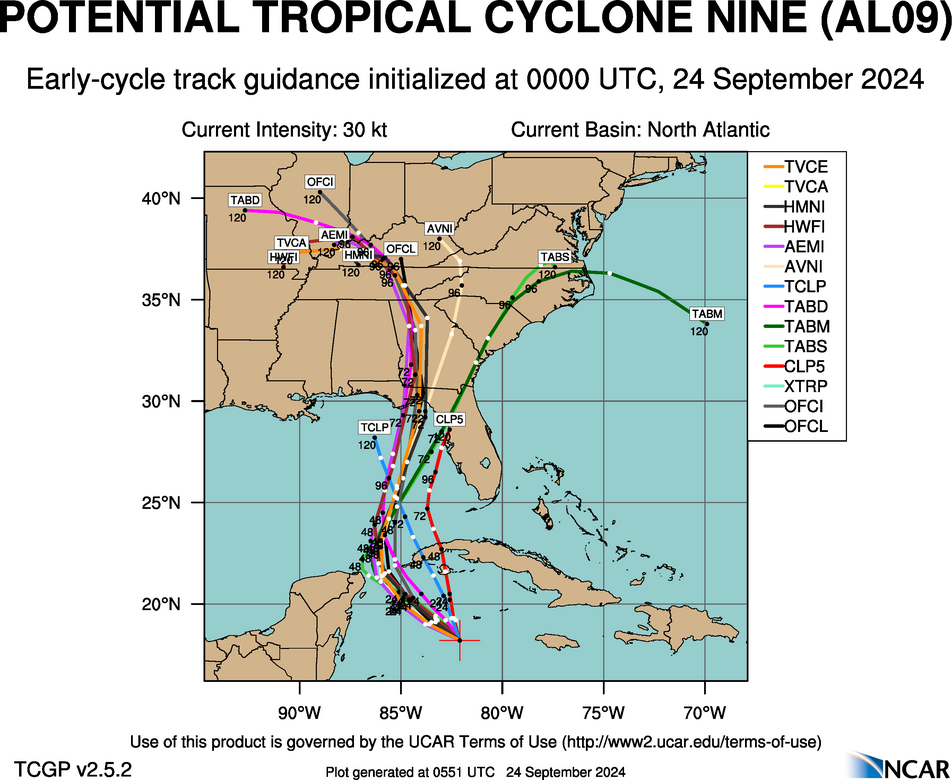
Ken711 wrote:Steve wrote:Early cycles 00z
https://hurricanes.ral.ucar.edu/realtim ... _early.png
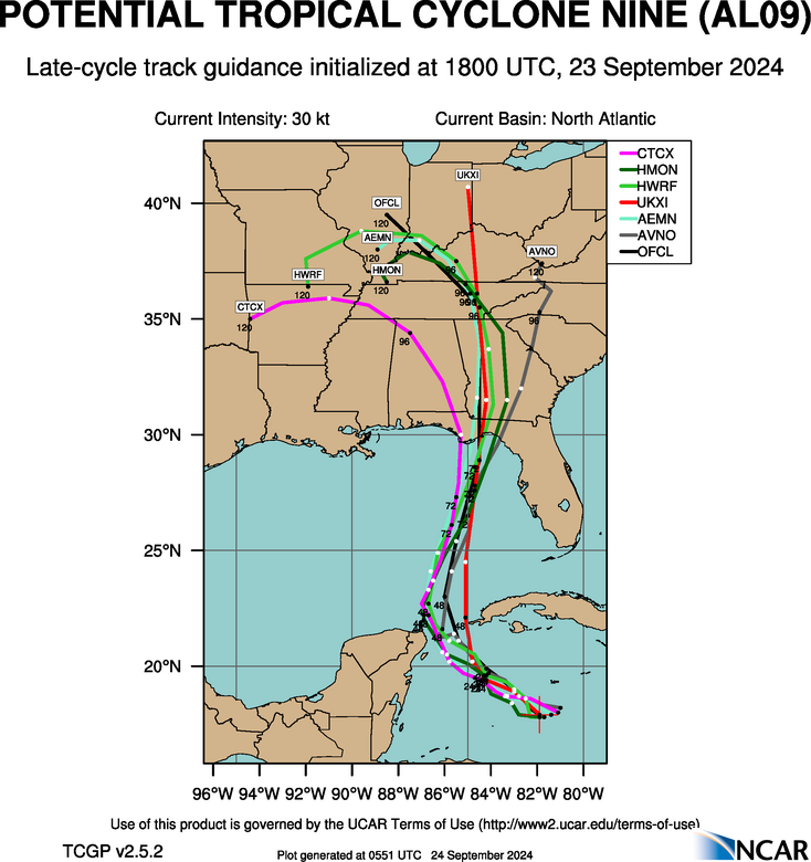
Late Cycle 18z
https://hurricanes.ral.ucar.edu/realtim ... k_late.png
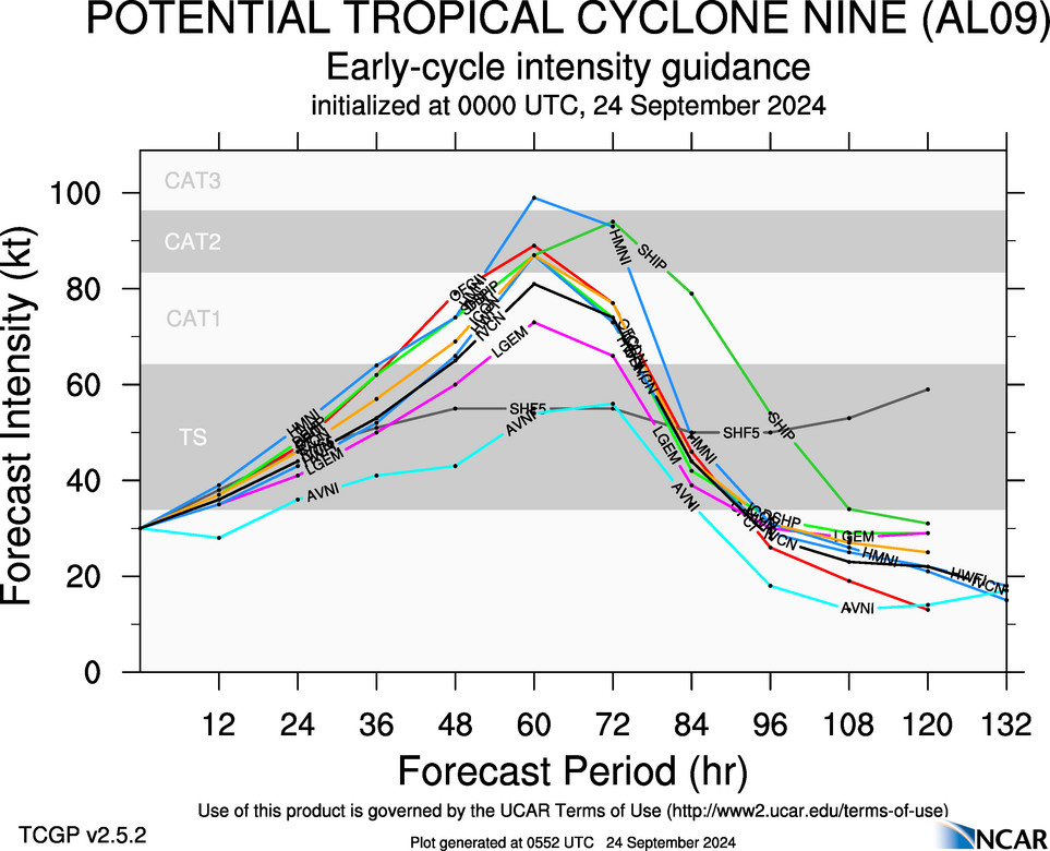
Early cycle intensity 00z
https://hurricanes.ral.ucar.edu/realtim ... _early.png
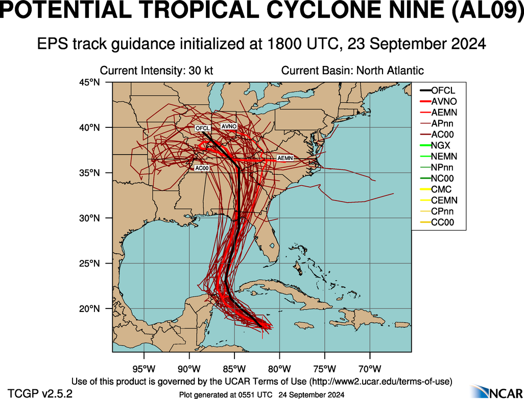
Late cycle 18z EPS
https://hurricanes.ral.ucar.edu/realtim ... l_late.png
Looks like it’s all coalescing around or just east of Apalachicola mostly with perhaps Panama City being the farthest west. With a few deviations, this has been the target zone for a couple of days. We are within the time frame where models are usually pretty damn close. That’s not to say there isn’t a chance this could go a bit east or west. But it’s likely not going to deviate that much from what we are seeing now
What is causing the system to curve to the west after it makes landfall and continues into Georgia?
Some of the energy being entrained by the cut off low.
1 likes
Re: ATL: NINE - Models
DunedinDave wrote:Steve wrote:Early cycles 00z
https://hurricanes.ral.ucar.edu/realtim ... _early.png
Late Cycle 18z
https://hurricanes.ral.ucar.edu/realtim ... k_late.png
Early cycle intensity 00z
https://hurricanes.ral.ucar.edu/realtim ... _early.png
Late cycle 18z EPS
https://hurricanes.ral.ucar.edu/realtim ... l_late.png
Looks like it’s all coalescing around or just east of Apalachicola mostly with perhaps Panama City being the farthest west. With a few deviations, this has been the target zone for a couple of days. We are within the time frame where models are usually pretty damn close. That’s not to say there isn’t a chance this could go a bit east or west. But it’s likely not going to deviate that much from what we are seeing now
Is the center right on those models? That looks like old one. Center seems to be reforming just south of the Caymans right now. Those models have the center far west of that/
It doesn’t really matter because the globals aren’t tracking a center. They are more macro pattern.
1 likes
-
DunedinDave
- Category 1

- Posts: 269
- Joined: Fri Aug 25, 2023 10:31 am
Re: ATL: NINE - Models
So if the center is further east than what the NHC says, does that mean the tracks will shift that way, too, or no?
1 likes
Re: ATL: NINE - Models
chris_fit wrote:Steve wrote:Early cycles 00z
https://hurricanes.ral.ucar.edu/realtim ... _early.png
Late Cycle 18z
https://hurricanes.ral.ucar.edu/realtim ... k_late.png
Early cycle intensity 00z
https://hurricanes.ral.ucar.edu/realtim ... _early.png
Late cycle 18z EPS
https://hurricanes.ral.ucar.edu/realtim ... l_late.png
Looks like it’s all coalescing around or just east of Apalachicola mostly with perhaps Panama City being the farthest west. With a few deviations, this has been the target zone for a couple of days. We are within the time frame where models are usually pretty damn close. That’s not to say there isn’t a chance this could go a bit east or west. But it’s likely not going to deviate that much from what we are seeing now
Why are the 18z EPS you posted different than the 18z EPS I posted few min earlier?
Late cycle which are run later. Those are all experimental though I figure everyone knew that though my bad. The early cycles offer clues to upcoming models and the lates are run after the models. Here is the guide link to the early cycle. If you click up in the options bar each type of run is explained.
https://hurricanes.ral.ucar.edu/guide/early/
Last edited by Steve on Mon Sep 23, 2024 9:04 pm, edited 2 times in total.
0 likes
-
StPeteMike
- Category 2
- Posts: 657
- Joined: Thu Jun 07, 2018 11:26 pm
Re: ATL: NINE - Models
DunedinDave wrote:So if the center is further east than what the NHC says, does that mean the tracks will shift that way, too, or no?
Possibly, but they’ll need more than models to shift the track east. Early morning the models seemed to be hinting east and NHC still held steady with their projected path.
1 likes
The above post is not official and should not be used as such. It is the opinion of the poster and may or may not be backed by sound meteorological data. It is not endorsed by any professional institution or storm2k.org. For official information, please refer to the NHC and NWS products.
-
Stormlover70
- Tropical Storm

- Posts: 194
- Age: 56
- Joined: Fri Jun 21, 2024 5:31 am
- Location: New port richey
Re: ATL: NINE - Models
depends on where the actual center is. Recon should tell the tail. Not liking this one bit.DunedinDave wrote:So if the center is further east than what the NHC says, does that mean the tracks will shift that way, too, or no?
1 likes
Re: ATL: NINE - Models
DunedinDave wrote:So if the center is further east than what the NHC says, does that mean the tracks will shift that way, too, or no?
The hurricane models are run off the specific systems. This would be less pronounced with the globals because while they do factor positions of weather items and juxtapositions of adjacent ones, they are looking at overall rather than tracking a specific system if that makes sense. Obviously when they initialize at a big variant from where a named storm is, you can throw them out. But if it’s just a few tenths of a degree, you can extrapolate that variance.
1 likes
-
ConvergenceZone
.gif)
- Category 5

- Posts: 5241
- Joined: Fri Jul 29, 2005 1:40 am
- Location: Northern California
Re: ATL: NINE - Models
ronjon wrote:18z Euro into big bend similar to 12z but weaker at 988 mb.
Normally I wouldn't pay attention, but it's interesting that we are seeing a weakening trend with pretty much all of the models. So they are obviously sniffing out something that the NHC and we aren't. So it appears the NHC is actually above the model intensity guidance now. I think they will hold the intensity tonight, but we'll see if the models showing weakening(it they don't flip againg) will make them lower their forecasted landfall strength.
Last edited by ConvergenceZone on Mon Sep 23, 2024 9:22 pm, edited 1 time in total.
0 likes
Re: ATL: NINE - Models
ConvergenceZone wrote:ronjon wrote:18z Euro into big bend similar to 12z but weaker at 988 mb.
Normally I wouldn't pay attention, but it's interesting that we are seeing a weakening trend with pretty much all of the models. So they are obviously sniffing out something that the NHC and we aren't.
There are caveats with this run of 18z models though. Time to look at Nam 12km.
1 likes
-
StPeteMike
- Category 2
- Posts: 657
- Joined: Thu Jun 07, 2018 11:26 pm
Re: ATL: NINE - Models
ConvergenceZone wrote:ronjon wrote:18z Euro into big bend similar to 12z but weaker at 988 mb.
Normally I wouldn't pay attention, but it's interesting that we are seeing a weakening trend with pretty much all of the models. So they are obviously sniffing out something that the NHC and we aren't.
From what I read earlier, the 18z runs ran on the llc that was waning and not on the new center.
1 likes
The above post is not official and should not be used as such. It is the opinion of the poster and may or may not be backed by sound meteorological data. It is not endorsed by any professional institution or storm2k.org. For official information, please refer to the NHC and NWS products.
-
ConvergenceZone
- Category 5
- Posts: 5241
- Joined: Fri Jul 29, 2005 1:40 am
- Location: Northern California
Re: ATL: NINE - Models
StPeteMike wrote:ConvergenceZone wrote:ronjon wrote:18z Euro into big bend similar to 12z but weaker at 988 mb.
Normally I wouldn't pay attention, but it's interesting that we are seeing a weakening trend with pretty much all of the models. So they are obviously sniffing out something that the NHC and we aren't.
From what I read earlier, the 18z runs ran on the llc that was waning and not on the new center.
really? I must have missed that then, my bad.
0 likes
-
DunedinDave
- Category 1
- Posts: 269
- Joined: Fri Aug 25, 2023 10:31 am
Re: ATL: NINE - Models
With this new center and the incoming low pressure, I have a hard time seeing it getting as far west as the models say before making that turn. It’s got to start picking up speed quickly.
1 likes
-
Dean4Storms
- S2K Supporter

- Posts: 6358
- Age: 63
- Joined: Sun Aug 31, 2003 1:01 pm
- Location: Miramar Bch. FL
Re: ATL: NINE - Models
No way to know from satellite imagery if a LLC is further east under the MLC until recon gets back. Appears the MLC is sheared to the east of the earlier broad surface circulation that recon found. Any further delay in this organizing and deepening to be able to feel the CONUS trough and get pulled northward away from the CAG and this could get further west IMO.
1 likes
-
StPeteMike
- Category 2
- Posts: 657
- Joined: Thu Jun 07, 2018 11:26 pm
Re: ATL: NINE - Models
ConvergenceZone wrote:StPeteMike wrote:ConvergenceZone wrote:
Normally I wouldn't pay attention, but it's interesting that we are seeing a weakening trend with pretty much all of the models. So they are obviously sniffing out something that the NHC and we aren't.
From what I read earlier, the 18z runs ran on the llc that was waning and not on the new center.
really? I must have missed that then, my bad.
You’re good man!
0 likes
The above post is not official and should not be used as such. It is the opinion of the poster and may or may not be backed by sound meteorological data. It is not endorsed by any professional institution or storm2k.org. For official information, please refer to the NHC and NWS products.

Re: ATL: NINE - Models
DunedinDave wrote:With this new center and the incoming low pressure, I have a hard time seeing it getting as far west as the models say before making that turn. It’s got to start picking up speed quickly.
The ESE winds at Grand Cayman and the Cayman islands radar both suggest the previous LLC is still dominant and moving west pretty quickly.
1 likes
Kendall -> SLO -> PBC
Memorable Storms: Katrina (for its Florida landfall...) Wilma Matthew Irma
Memorable Storms: Katrina (for its Florida landfall...) Wilma Matthew Irma
Re: ATL: NINE - Models
Ubuntwo wrote:DunedinDave wrote:With this new center and the incoming low pressure, I have a hard time seeing it getting as far west as the models say before making that turn. It’s got to start picking up speed quickly.
The ESE winds at Grand Cayman and the Cayman islands radar both suggest the previous LLC is still dominant and moving west pretty quickly.
My understanding is that one could die off and another drill down from the mlc
0 likes

Re: ATL: NINE - Models
WaveBreaking wrote:How it started vs how it’s going
https://i.imgur.com/968u2yG.png
https://i.imgur.com/dhssNmx.png
In all seriousness, the 18z HAFS runs have the same problem as the 12z runs, but in the opposite direction.
If it panned out, Helene would be a large and strong hurricane.
2 likes
Re: ATL: NINE - Models
NAM 12km gets to Alligator Point at 966. Nam landfall intensities get better closer to landfall.
1 likes
Who is online
Users browsing this forum: No registered users and 94 guests