ATL: HELENE - Models
Moderator: S2k Moderators

Re: ATL: NINE - Models
A member on the discussion thread for 97L....mentioned Wxnan 57s reference to the ICON model.....what is this model showing?...
0 likes


Re: ATL: NINE - Models
Some new data:
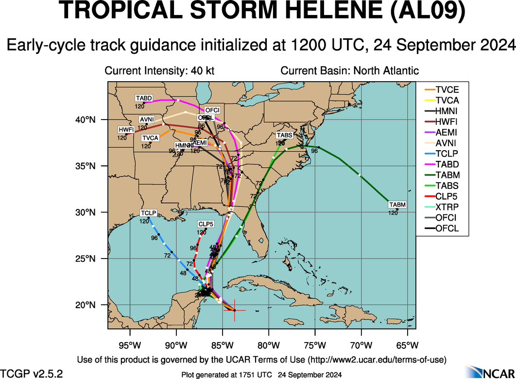
Early cycle 12z
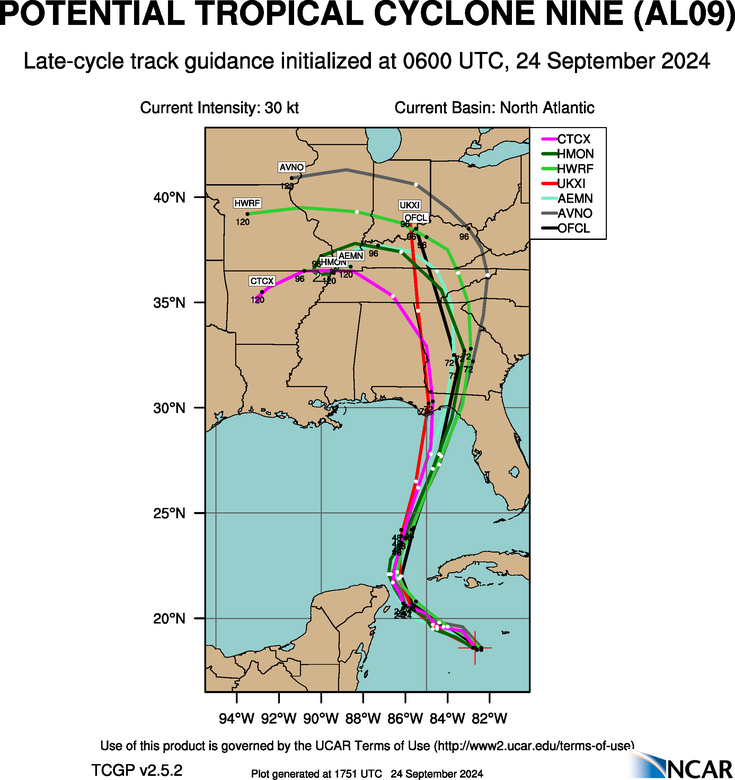
Late cycle 06z
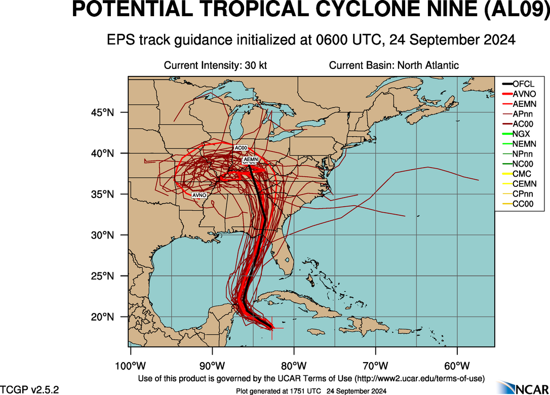
Late cycle EPS 06z
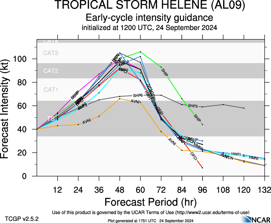
Early Cycle Intensity Guidance 12z
Early cycle 12z
Late cycle 06z
Late cycle EPS 06z
Early Cycle Intensity Guidance 12z
0 likes
Re: ATL: NINE - Models
underthwx wrote:A member on the discussion thread for 97L....mentioned Wxnan 57s reference to the ICON model.....what is this model showing?...
It'll be running 12z close to the 10:00am CDT hour. For 06z, it landfalls just north of Tampa at 21z Thursday early evening at 952. Here's the direct link to forecast hour 63 (5pm EDT) just prior to landfall.
https://www.tropicaltidbits.com/analysi ... 2406&fh=63
1 likes

Re: ATL: NINE - Models
underthwx wrote:A member on the discussion thread for 97L....mentioned Wxnan 57s reference to the ICON model.....what is this model showing?...
Farther east and more of a threat to the Tampa area rather than big big/panhandle area. ICON has been pretty insistent on a more eastern track. ICON has been able to pick up on things earlier and stick to them.
0 likes

Re: ATL: NINE - Models
underthwx wrote:A member on the discussion thread for 97L....mentioned Wxnan 57s reference to the ICON model.....what is this model showing?...
12z ICON will run soon (within the hour), but the most recent 06z run of ICON is one of the easternmost models. Landfall is still well west of Tampa, but it would experience a signficant surge impact. Landfall just south of Steinhachee.

1 likes

Re: ATL: NINE - Models
06z Euro slightly stronger at 982 mb into Big Bend. I have to say the European model track has not varied significantly over the last 2 days of model runs with its landfall just east of Apalachicola. It is locked in.
0 likes
Re: ATL: NINE - Models
kevin wrote:underthwx wrote:A member on the discussion thread for 97L....mentioned Wxnan 57s reference to the ICON model.....what is this model showing?...
12z ICON will run soon (within the hour), but the most recent 06z run of ICON is one of the easternmost models. Landfall is still well west of Tampa, but it would experience a signficant surge impact. Landfall just south of Steinhachee.
https://i.imgur.com/qlMqbI0.gif
Thanks for your reply....this system is proving itself to be tricky to forecast.....I expected 97L to be designated a TS by this morning....but not so yet.....
1 likes
Re: ATL: NINE - Models
Powellrm wrote:underthwx wrote:A member on the discussion thread for 97L....mentioned Wxnan 57s reference to the ICON model.....what is this model showing?...
Farther east and more of a threat to the Tampa area rather than big big/panhandle area. ICON has been pretty insistent on a more eastern track. ICON has been able to pick up on things earlier and stick to them.
Yes.....I see what you mean....I have wondered the past 2 days...if 97L will track more eastward?....today should resolve some of the unanswered questions regarding this system...
0 likes
Re: ATL: NINE - Models
Steve wrote:underthwx wrote:A member on the discussion thread for 97L....mentioned Wxnan 57s reference to the ICON model.....what is this model showing?...
It'll be running 12z close to the 10:00am CDT hour. For 06z, it landfalls just north of Tampa at 21z Thursday early evening at 952. Here's the direct link to forecast hour 63 (5pm EDT) just prior to landfall.
https://www.tropicaltidbits.com/analysi ... 2406&fh=63
Thanks Steve!.....we shall soon see.....thanks for the link!
1 likes
Re: ATL: NINE - Models
yeah for sure underthwx.
-------------
What is most interesting to me on those early 12z and late 06z tracks is that almost all of them come in around Franklin or Wakulla County. There are a couple of deviations into the Peninsula but I think that's going to be the range of where the storm hits. ICON hits a bit SE of there which is certainly possible. Though it has wobbled a bit with landfall points as new runs came out. So it may be onto something, or it could be an eastern outlier. Either way it's going to be very close and we're talking about only maybe 170 nautical miles/as the crow swims from Tampa to Apalachicola. That's not much.
Last edited by Steve on Tue Sep 24, 2024 9:45 am, edited 1 time in total.
0 likes
Re: ATL: NINE - Models
kevin wrote:12z ICON has started on Pivotalweather, initializes as a 1002 mb TS.
I like that if the location was good (as of 7am CDT of course). 996 in 12 hours (8EDT tonight).
https://www.pivotalweather.com/model.ph ... &dpdt=&mc=
Last edited by Steve on Tue Sep 24, 2024 9:48 am, edited 1 time in total.
0 likes
Re: ATL: NINE - Models
When you think about it regarding the model runs for this storm, there is a pretty solid consensus on landfall 2 days out. I know there are concerns with an eastward shift (I was slightly manic myself yesterday after viewing the 18z ICON), but so far it appears the limiting factor toward a dramatic shift east might be the mid-upper level low sinking south of Arkansas rather than it moving east in a more progressive fashion. This factor and the Atlantic ridge to the east seems to creating a superhighway path between the 2 features that is rather consistent.
1 likes
-
DunedinDave
- Category 1

- Posts: 269
- Joined: Fri Aug 25, 2023 10:31 am
Re: ATL: NINE - Models
ronjon wrote:06z Euro slightly stronger at 982 mb into Big Bend. I have to say the European model track has not varied significantly over the last 2 days of model runs with its landfall just east of Apalachicola. It is locked in.
GFS hasn't budged either. What's interesting is they both approach the Fla West coast but the Euro seems to curve to more of a due north direction, leading to more of a landfall in Appalachee Bay, whereas the GFS keeps the NE to NNE motion the whole way through, making landfall just east of Steinhatchee and moving it into Georgia. The ICON seems to agree more with the GFS.
0 likes
Re: ATL: NINE - Models
Steve wrote:kevin wrote:12z ICON has started on Pivotalweather, initializes as a 1002 mb TS.
I like that if the location was good (as of 7am CDT of course). 996 in 12 hours (8EDT tonight).
https://www.pivotalweather.com/model.ph ... &dpdt=&mc=
It initializes at 19.4N, 83.9W. A few decimal points west of where it probably was at 12z.
1 likes
-
lsuhurricane
- Category 1
- Posts: 270
- Joined: Tue Aug 15, 2017 2:53 pm
Re: ATL: NINE - Models
12z ICON is about 5mb stronger than the 6z run thus far at 18 hrs out. Same general location
0 likes
Re: ATL: NINE - Models
kevin wrote:Steve wrote:kevin wrote:12z ICON has started on Pivotalweather, initializes as a 1002 mb TS.
I like that if the location was good (as of 7am CDT of course). 996 in 12 hours (8EDT tonight).
https://www.pivotalweather.com/model.ph ... &dpdt=&mc=
It initializes at 19.4N, 83.9W. A few decimal points west of where it probably was at 12z.
Making that run for close to the tip of the Yucatan at 18 hours (992mb). Probably will just miss it or maybe hit Cozumel on the way through there. Edit no it jumps north through the Channel. 986 and intensifying at 24 hours pulling through the YC.
Last edited by Steve on Tue Sep 24, 2024 9:51 am, edited 1 time in total.
0 likes
-
lsuhurricane
- Category 1
- Posts: 270
- Joined: Tue Aug 15, 2017 2:53 pm
-
lsuhurricane
- Category 1
- Posts: 270
- Joined: Tue Aug 15, 2017 2:53 pm
Re: ATL: NINE - Models
Safe to say this ICON run will be intense.....
972 mb @ 39 hrs out
964 mb @ 45 hrs out
972 mb @ 39 hrs out
964 mb @ 45 hrs out
0 likes
Who is online
Users browsing this forum: No registered users and 73 guests