ATL: ERNESTO - Post-Tropical - Discussion

Moderator: S2k Moderators

Message
Author
hipshot
Category 2
Category 2
Posts: 591
Joined: Tue Jul 06, 2010 9:18 pm
Location: Dallas, Texas

Re: ATL: INVEST 98L - Discussion

#61 Postby hipshot » Sat Aug 10, 2024 9:10 pm

Craters wrote:
hipshot wrote:
ConvergenceZone wrote:So I wanted to check today to see if the forecast was still trending "out to sea" after the islands. The funny thing is, I had my answer before I clicked on this thread. Once I saw the thread only had 2 pages, I knew, "Yep, still out to sea" :) But of course I wanted to post this, so Is till clicked on the thread anyway lol. Page total tells ya everything :)


I don't know about OTS yet, still a long way to go. It still looks like it is going to hit the LA and GA to some extent so who know.

Geez. I must be tired. I actually spent a few seconds wondering "Now, how in the world could it hit Louisiana and Georgia without going through MIssissippi, Alabama, or Florida?"

Duh.


Sorry about the abbreviation, I was having trouble spelling Antillies...oops Antilles...see :roll:
2 likes   

User avatar
'CaneFreak
Category 5
Category 5
Posts: 1486
Joined: Mon Jun 05, 2006 10:50 am
Location: New Bern, NC

Re: ATL: INVEST 98L - Discussion

#62 Postby 'CaneFreak » Sat Aug 10, 2024 10:40 pm

I’m struggling a bit with the placement of this invest tag. Can anyone help me out here? I’m looking at CIMMS analysis and it looks like the best rotation is to the southeast of where they’ve placed the invest tag up by 12 N and 42 W. The best vorticity is closer to 10.5 N and 40 W. Also, if you put on the shear analysis the anticyclone is to the east of the invest tag. Also if you look at the steering flow, it looks like it is going to go south of where the models are taking it in my opinion. It’s not stacked yet obviously (we all know that) but it is just interesting. I wonder if it will end up consolidating a bit farther to the southeast than forecast. Check this site out. Turn on “Vort” (Vorticity or spin), “Shear”, and “DLM” (Mean Layer Steering). Run a loop of the satellite too while you are at it. “VIS/SWIR” at the top and loop at the left. :)

http://tropic.ssec.wisc.edu/real-time/storm.php?&basin=atlantic&sname=98L&invest=YES&zoom=4&img=1&vars=11111000000000000000000&loop=0&llval=OFF
2 likes   

Hurricane Mike
Category 2
Category 2
Posts: 644
Joined: Tue Apr 10, 2018 7:44 am

Re: ATL: INVEST 98L - Discussion

#63 Postby Hurricane Mike » Sat Aug 10, 2024 10:53 pm

I was more confident about out to sea yesterday, but it is just too early until we have a system well developed. 
4 likes   

User avatar
REDHurricane
Category 1
Category 1
Posts: 394
Age: 27
Joined: Sun Jul 03, 2022 2:36 pm
Location: Northeast Pacific Ocean

Re: ATL: INVEST 98L - Discussion

#64 Postby REDHurricane » Sat Aug 10, 2024 11:20 pm

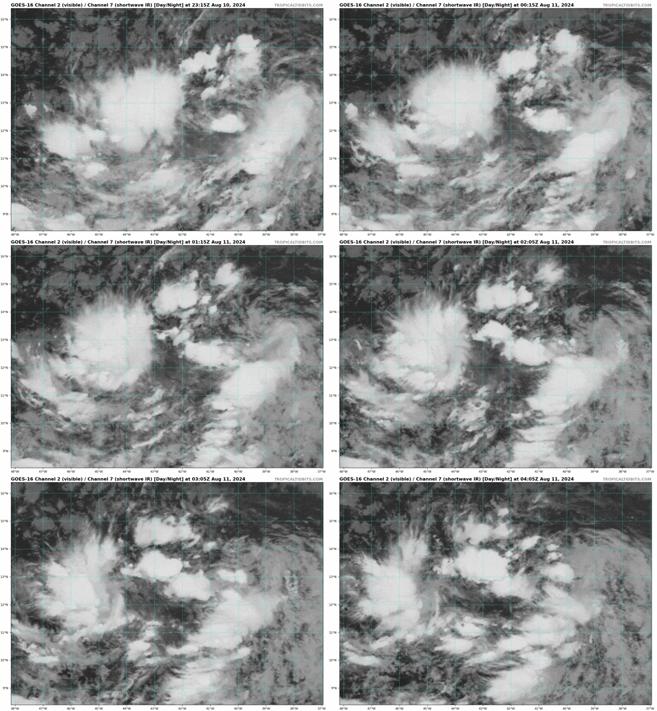
Definitely getting more organized now near 13ºN, 40ºW:

Image
4 likes   

User avatar
cycloneye
Admin
Admin
Posts: 143864
Age: 68
Joined: Thu Oct 10, 2002 10:54 am
Location: San Juan, Puerto Rico

Re: ATL: INVEST 98L - Discussion

#65 Postby cycloneye » Sun Aug 11, 2024 7:07 am

Tropical Weather Outlook
NWS National Hurricane Center Miami FL
800 AM EDT Sun Aug 11 2024

For the North Atlantic...Caribbean Sea and the Gulf of Mexico:

1. Near the Lesser and Greater Antilles (AL98):
Showers and thunderstorms continue to show some signs of
organization in association with a broad area of low pressure
located about 1000 miles east of the Lesser Antilles.
Environmental conditions appear conducive for gradual development of
this system, and a tropical depression is likely to form within the
next couple of days while the system approaches and then moves near
or over the Leeward Islands. Interests on these islands should
continue to monitor the progress of this system, and watches
or warnings could be required for portions of the area as soon as
later today. The system could approach portions of the Greater
Antilles by the middle of the week.
* Formation chance through 48 hours...high...70 percent.
* Formation chance through 7 days...high...90 percent.


Forecaster Cangialosi
2 likes   
Visit the Caribbean-Central America Weather Thread where you can find at first post web cams,radars
and observations from Caribbean basin members Click Here

TomballEd
Category 2
Category 2
Posts: 580
Age: 61
Joined: Wed Aug 16, 2023 4:52 pm
Location: Spring/Klein area, not Tomball

Re: ATL: INVEST 98L - Discussion

#66 Postby TomballEd » Sun Aug 11, 2024 7:56 am

Impact on the Greater Antilles looks likely. GFS ensembles look stronger, but none shows really intense hurricanes. Maybe Puerto Rico and Hispaniola avoid a serious impact, but that isn't certain.

CONUS impact looks increasingly less likely.
0 likes   

Sciencerocks
Category 5
Category 5
Posts: 8903
Age: 39
Joined: Thu Jul 06, 2017 1:51 am

Re: ATL: INVEST 98L - Discussion

#67 Postby Sciencerocks » Sun Aug 11, 2024 8:07 am

Image
3 likes   

User avatar
hiflyer
S2K Supporter
S2K Supporter
Posts: 560
Joined: Wed Sep 08, 2004 11:24 am
Location: West Broward Florida

Re: ATL: INVEST 98L - Discussion

#68 Postby hiflyer » Sun Aug 11, 2024 8:31 am

“Out to sea”…is that another phrase for Bermuda? Grin! Seeing some very low pressure numbers developing on the models that go out that far in time in proximity to Bermuda.
1 likes   

User avatar
WaveBreaking
Category 2
Category 2
Posts: 562
Joined: Sun Jun 30, 2024 11:33 am
Location: US

Re: ATL: INVEST 98L - Discussion

#69 Postby WaveBreaking » Sun Aug 11, 2024 10:19 am

The N part of 98L’s overall vorticity has recently been getting more constant convection along with a more focused area of rotation. This might be where the core tries to set up. Also note the broad arc of small flareups at the end of the loop on the S side. Those might be the start of some primitive banding.

Image
5 likes   
I am NOT a professional meteorologist, so take all of my posts with a grain of salt. My opinions are mine and mine alone.

User avatar
wxman57
Moderator-Pro Met
Moderator-Pro Met
Posts: 22951
Age: 67
Joined: Sat Jun 21, 2003 8:06 pm
Location: Houston, TX (southwest)

Re: ATL: INVEST 98L - Discussion

#70 Postby wxman57 » Sun Aug 11, 2024 10:59 am

If it develops prior to passing PR, then it has a clear shot to turn north, where it would threaten Bermuda and possibly NS/NF in about 9 days. I put the center at 13.8N/45.6W now. Weak rotation there.
2 likes   

User avatar
abajan
S2K Supporter
S2K Supporter
Posts: 4229
Joined: Sun Sep 07, 2003 5:10 am
Location: Barbados

Re: ATL: INVEST 98L - Discussion

#71 Postby abajan » Sun Aug 11, 2024 12:33 pm

Tropical Weather Outlook
NWS National Hurricane Center Miami FL
200 PM EDT Sun Aug 11 2024

For the North Atlantic...Caribbean Sea and the Gulf of Mexico:

1. Near the Lesser and Greater Antilles (AL98):
Showers and thunderstorms continue to show some signs of
organization in association with a broad area of low pressure
located a little less than 1000 miles east of the Lesser Antilles.
Environmental conditions appear conducive for gradual development of
this system, and a tropical depression is likely to form within the
next day or two while the system approaches and then moves near or
over the Leeward Islands. Interests on these islands should
continue to monitor the progress of this system, and watches will
likely be required for portions of the area as soon as this
afternoon. The system could approach portions of the Greater
Antilles by the middle of the week.
* Formation chance through 48 hours...high...80 percent.
* Formation chance through 7 days...high...90 percent.


Forecaster Hagen/Cangialosi
1 likes   

User avatar
lilbump3000
Category 4
Category 4
Posts: 966
Age: 37
Joined: Sat Sep 20, 2003 10:09 am
Location: New Orleans, Louisiana
Contact:

Re: ATL: INVEST 98L - Discussion

#72 Postby lilbump3000 » Sun Aug 11, 2024 12:42 pm

(August 11) Advisories will be initiated on Potential Tropical Cyclone Five later this afternoon, as watches and warnings will be required for portions of the Lesser Antilles Islands.

https://www.youtube.com/@w.o.f.weathero ... irmation=1

Image

Image
1 likes   

Sciencerocks
Category 5
Category 5
Posts: 8903
Age: 39
Joined: Thu Jul 06, 2017 1:51 am

Re: ATL: INVEST 98L - Discussion

#73 Postby Sciencerocks » Sun Aug 11, 2024 12:50 pm

Image

Doesn't look to be anywhere near closed yet and any "broad" circ is on the eastern portion of the convection. Development will be slow over the next few days.
1 likes   

User avatar
ConvergenceZone
Category 5
Category 5
Posts: 5194
Joined: Fri Jul 29, 2005 1:40 am
Location: Northern California

Re: ATL: INVEST 98L - Discussion

#74 Postby ConvergenceZone » Sun Aug 11, 2024 12:58 pm

wxman57 wrote:If it develops prior to passing PR, then it has a clear shot to turn north, where it would threaten Bermuda and possibly NS/NF in about 9 days. I put the center at 13.8N/45.6W now. Weak rotation there.


Yea after is passes the islands(and hopefully north of them) the only other thing I'm worried about when it comes to Debbie is Bermuda. And yea Nova Scotia is still a possibility at this point. Let's hope it's zooming really fast or is falling apart by the time it reaches that area.
0 likes   

User avatar
Blown Away
S2K Supporter
S2K Supporter
Posts: 10140
Joined: Wed May 26, 2004 6:17 am

Re: ATL: INVEST 98L - Discussion

#75 Postby Blown Away » Sun Aug 11, 2024 1:08 pm

Over past 15 or so years it seems that many systems make hard north turns deep from the tropics… A few decades ago it seemed most moved around the periphery of the BH while recurving… Maybe it’s just me… 8-)
0 likes   
Hurricane Eye Experience: David 79, Irene 99, Frances 04, Jeanne 04, Wilma 05... EYE COMING MY WAY IN 2024…
Hurricane Brush Experience: Andrew 92, Erin 95, Floyd 99, Matthew 16, Irma 17, Ian 22, Nicole 22…

LarryWx
Category 5
Category 5
Posts: 6246
Joined: Sun Sep 07, 2003 2:04 pm
Location: GA

Re: ATL: INVEST 98L - Discussion

#76 Postby LarryWx » Sun Aug 11, 2024 1:30 pm

Blown Away wrote:Over past 15 or so years it seems that many systems make hard north turns deep from the tropics… A few decades ago it seemed most moved around the periphery of the BH while recurving… Maybe it’s just me… 8-)


2024 has already had Debby that didn’t. 2023 and 2014 did but I think that’s more common for El Niño. 2010 had a pretty good number but then it also had a good number move W into C America/MX. Most other years of last 15 look like a mix.
1 likes   
Personal Forecast Disclaimer:
The posts in this forum are NOT official forecasts and should not be used as such. They are just the opinion of the poster and may or may not be backed by sound meteorological data. They are NOT endorsed by any professional institution or storm2k.org. For official information, please refer to the NHC and NWS products.

Stormlover70
Tropical Storm
Tropical Storm
Posts: 167
Age: 55
Joined: Fri Jun 21, 2024 5:31 am
Location: New port richey

Re: ATL: INVEST 98L - Discussion

#77 Postby Stormlover70 » Sun Aug 11, 2024 1:42 pm

Blown Away wrote:Over past 15 or so years it seems that many systems make hard north turns deep from the tropics… A few decades ago it seemed most moved around the periphery of the BH while recurving… Maybe it’s just me… 8-)
that is climate change.
0 likes   

tolakram
Admin
Admin
Posts: 19990
Age: 61
Joined: Sun Aug 27, 2006 8:23 pm
Location: Florence, KY (name is Mark)

Re: ATL: INVEST 98L - Discussion

#78 Postby tolakram » Sun Aug 11, 2024 1:44 pm

lilbump3000 wrote:(August 11) Advisories will be initiated on Potential Tropical Cyclone Five later this afternoon, as watches and warnings will be required for portions of the Lesser Antilles Islands.

https://www.youtube.com/@w.o.f.weathero ... irmation=1

[url]https://imagizer.imageshack.com/v2/xq70/923/HjDozW.jpg [/url]

[url]https://imagizer.imageshack.com/img924/706/bAQ0kJ.gif [/url]


The NHC will not be issuing advisories as far as I can tell. Correct me if I'm wrong.

Please be clear if you are indicating your own advisories vs an official source. Thanks.
7 likes   
M a r k
- - - - -
Join us in chat: Storm2K Chatroom Invite. Android and IOS apps also available.

The posts in this forum are NOT official forecasts and should not be used as such. Posts are NOT endorsed by any professional institution or STORM2K.org. For official information and forecasts, please refer to NHC and NWS products.

Cachondo23
Tropical Depression
Tropical Depression
Posts: 73
Joined: Wed May 25, 2022 5:56 am

Re: ATL: INVEST 98L - Discussion

#79 Postby Cachondo23 » Sun Aug 11, 2024 2:16 pm

I see a Marilyn 95’ analog for this storm. Mainly in terms of the potential route. We shall see.
0 likes   

User avatar
wxman57
Moderator-Pro Met
Moderator-Pro Met
Posts: 22951
Age: 67
Joined: Sat Jun 21, 2003 8:06 pm
Location: Houston, TX (southwest)

Re: ATL: INVEST 98L - Discussion

#80 Postby wxman57 » Sun Aug 11, 2024 2:24 pm

tolakram wrote:
lilbump3000 wrote:(August 11) Advisories will be initiated on Potential Tropical Cyclone Five later this afternoon, as watches and warnings will be required for portions of the Lesser Antilles Islands.

https://www.youtube.com/@w.o.f.weathero ... irmation=1

[url]https://imagizer.imageshack.com/v2/xq70/923/HjDozW.jpg [/url]

[url]https://imagizer.imageshack.com/img924/706/bAQ0kJ.gif [/url]


The NHC will not be issuing advisories as far as I can tell. Correct me if I'm wrong.

Please be clear if you are indicating your own advisories vs an official source. Thanks.


I can't confirm whether or not the NHC will start PTC advisories this afternoon, but the system may be producing TS wind in the islands within 48 hours, necessitating a TS watch. Development chances high. That meets there criteria for initiating PTC advisories. I'm close to 100% sure they'll start advisories this afternoon.
7 likes   


Return to “2024”

Who is online

Users browsing this forum: No registered users and 9 guests