ATL: HELENE - Models
Moderator: S2k Moderators
Re: ATL: HELENE - Models
12z Euro is pretty far west. Would involve Tallahassee and Atlanta again...
0 likes
-
Nederlander
- S2K Supporter

- Posts: 1259
- Joined: Sat Jul 19, 2008 4:28 pm
- Location: Conroe, TX
Re: ATL: HELENE - Models
lsuhurricane wrote:12z Euro run seems pretty locked in on a Cat 2 at landfall. Realistic projection here.
https://i.ibb.co/55RxLQK/9-km-ECMWF-Global-00z-12z-3-Hourly-Gulf-of-Mexico-MSLP.gif
Euro is once again underestimating strength... don't trust it, it's trash
4 likes


-
DunedinDave
- Category 1

- Posts: 269
- Joined: Fri Aug 25, 2023 10:31 am
Re: ATL: HELENE - Models
shah83 wrote:12z Euro is pretty far west. Would involve Tallahassee and Atlanta again...
It's almost identical to 0z and 6z track. Don't really see any move west.
0 likes

Re: ATL: HELENE - Models
12z Euro pretty much consistent with forecast track the last 2 days. Pressure at landfall has gradually dropped from 984 mb at 00z, to 982 mb at 06z, and now 976 mb at 12z.
1 likes

Re: ATL: HELENE - Models
lsuhurricane wrote:12z Euro run seems pretty locked in on a Cat 2 at landfall. Realistic projection here.
https://i.ibb.co/55RxLQK/9-km-ECMWF-Global-00z-12z-3-Hourly-Gulf-of-Mexico-MSLP.gif
Yeah that does seem pretty reasonable. @ 500 you can see how the trough grabs it and sets up for the next several days over the SEUS. However it gets replaced by a ridge at the end of the 10-day period.
https://www.pivotalweather.com/model.ph ... ecmwf_full
0 likes
-
StPeteMike

- Category 2

- Posts: 657
- Joined: Thu Jun 07, 2018 11:26 pm
Re: ATL: HELENE - Models
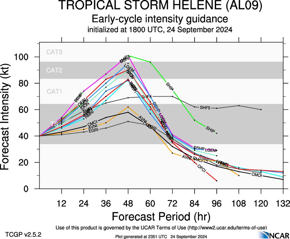
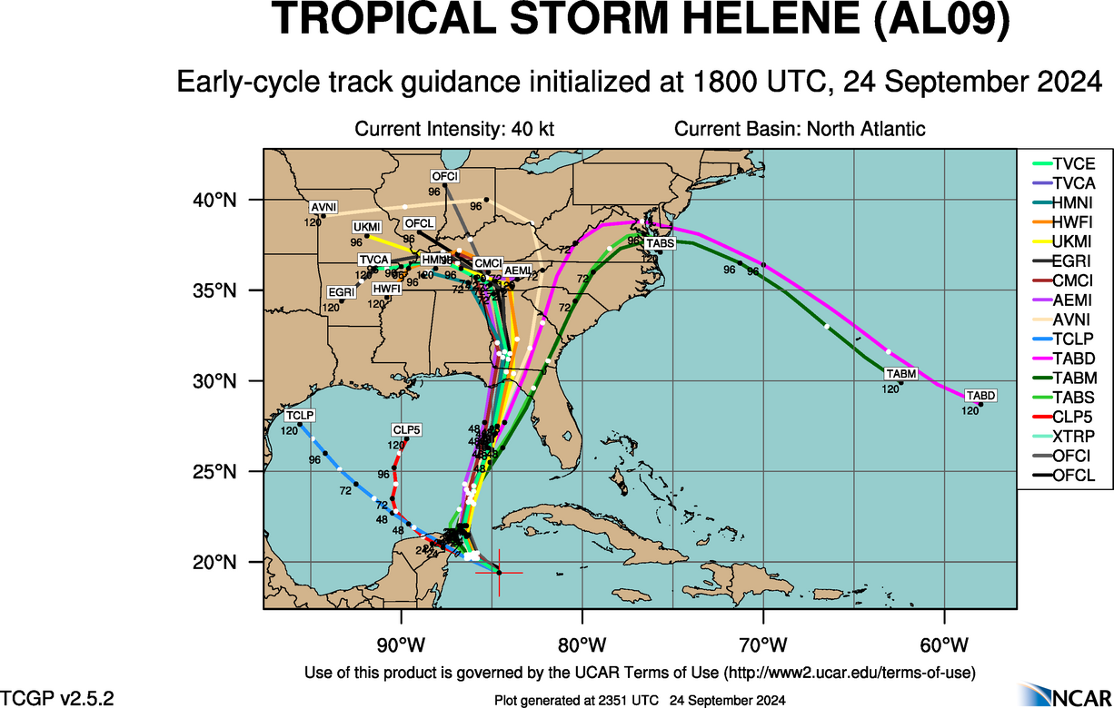
Steve wrote:And early cycle 18z track guidance
https://hurricanes.ral.ucar.edu/realtime/plots/northatlantic/2024/al092024/track_early/aal09_2024092418_track_early.png
Wow, first time seeing the accelerated right hooks on some of them. How good is TABS, Steve? I feel like I have fond memories of seeing people TABS is pretty reliable, but you are fine to correct me if wrong. And clearly, it’s one of many.
0 likes
The above post is not official and should not be used as such. It is the opinion of the poster and may or may not be backed by sound meteorological data. It is not endorsed by any professional institution or storm2k.org. For official information, please refer to the NHC and NWS products.
Re: ATL: HELENE - Models
StPeteMike wrote:Steve wrote:And early cycle 18z track guidance
https://hurricanes.ral.ucar.edu/realtime/plots/northatlantic/2024/al092024/track_early/aal09_2024092418_track_early.png
Wow, first time seeing the accelerated right hooks on some of them. How good is TABS, Steve? I feel like I have fond memories of seeing people TABS is pretty reliable, but you are fine to correct me if wrong. And clearly, it’s one of many.
They aren't useful (maybe barely) for track purposes. They follow the wind/shear and are Trajectory based as opposed to dynamical, consensus or statistical. They're barely better than Clipper in my opinion (probably worse sometimes). TWC has a page on these which references: Some models just follow the winds, and they are collectively known as the TABs (or Trajectory and Beta Models). These three models - shallow, medium and deep - are slightly more useful (than CLIP/XTRAP) because the closer they are together, they indicate that there is less wind shear in the atmosphere. On the contrary, if they are spread out, this is indicative that there is more wind shear and the system will likely stay weak. A weak system should not be monitored using the deep version of the TABs called TABD since those systems do not tap the upper portions of the atmosphere. Here's a link to the their article from 2022, "Hurricane Spaghetti Models: Four Things You Need to Know to Track Storms Like the Pros."
It's pretty educational, short and worth anyone's 5 minutes to read or even a favorites link for future reference.
https://weather.com/science/weather-exp ... -hurricane
Last edited by Steve on Tue Sep 24, 2024 2:55 pm, edited 2 times in total.
3 likes
-
DunedinDave
- Category 1
- Posts: 269
- Joined: Fri Aug 25, 2023 10:31 am
Re: ATL: HELENE - Models
A lot of those 18z models are left of the NHC forecast in the short term and Helene itself seems slightly right of the NHC short-term forecast. Again, every wobble moving forward makes a ton of difference.
2 likes
Re: ATL: HELENE - Models
^^ Note the "ICON" in TWC's list is a different ICON and not the German model we run on here all the time.
3 likes

Re: ATL: HELENE - Models
Whoa ICON ratcheting up a bit with a 947 nearly upon landfall in the big bend area before crushing Georgia, upstate SC, and western NC. Wow. Asheville NC getting rain prior to the storm as well. Major flood watch.
Last edited by Powellrm on Tue Sep 24, 2024 3:05 pm, edited 1 time in total.
0 likes
Re: ATL: HELENE - Models
Powellrm wrote:Whoa ICON ratcheting up a bit with a 947 nearly upon landfall in the big bend area before crushing Georgia, upstate SC, and western NC. Wow.
You looking at the 12z? That one has some 2 feet rain totals across all of WNC and W SC. 18z will be out in an hour or so but it only goes 5 days.
0 likes
Re: ATL: HELENE - Models
Steve wrote:Powellrm wrote:Whoa ICON ratcheting up a bit with a 947 nearly upon landfall in the big bend area before crushing Georgia, upstate SC, and western NC. Wow.
You looking at the 12z? That one has some 2 feet rain totals across all of WNC and W SC. 18z will be out in an hour or so but it only goes 5 days.
Yes. ICON is every 6 hours I believe? Absolutely devastating. If the ridge isn’t as prominent, and it drifts farther east into central NC-I’m in trouble. I just filled a bunch of sandbags today just in case.
1 likes
Re: ATL: HELENE - Models
Steve wrote:StPeteMike wrote:Steve wrote:And early cycle 18z track guidance
https://hurricanes.ral.ucar.edu/realtime/plots/northatlantic/2024/al092024/track_early/aal09_2024092418_track_early.png
Wow, first time seeing the accelerated right hooks on some of them. How good is TABS, Steve? I feel like I have fond memories of seeing people TABS is pretty reliable, but you are fine to correct me if wrong. And clearly, it’s one of many.
They aren't useful (maybe barely) for track purposes. They follow the wind/shear and are Trajectory based as opposed to dynamical, consensus or statistical. They're barely better than Clipper in my opinion (probably worse sometimes). TWC has a page on these which references: Some models just follow the winds, and they are collectively known as the TABs (or Trajectory and Beta Models). These three models - shallow, medium and deep - are slightly more useful (than CLIP/XTRAP) because the closer they are together, they indicate that there is less wind shear in the atmosphere. On the contrary, if they are spread out, this is indicative that there is more wind shear and the system will likely stay weak. A weak system should not be monitored using the deep version of the TABs called TABD since those systems do not tap the upper portions of the atmosphere. Here's a link to the their article from 2022, "Hurricane Spaghetti Models: Four Things You Need to Know to Track Storms Like the Pros."
It's pretty educational, short and worth anyone's 5 minutes to read or even a favorites link for future reference.
https://weather.com/science/weather-exp ... -hurricane
Hey Steve thanks for posting this! Great read.
2 likes

Re: ATL: HELENE - Models
Ryan Maue: Last updated model to arrive for 12z is the ecmwf hres and it shows a rather disheveled Helene at 975 mb cat 2+. However, wind shear from a upper-level trough to the wnw may keep from maximum potential.
0 likes
Robbielyn McCrary
I know just about enough to sound like I know what I'm talking about sometimes. But for your safety please follow the nhc for truly professional forecasting.
I know just about enough to sound like I know what I'm talking about sometimes. But for your safety please follow the nhc for truly professional forecasting.

Re: ATL: HELENE - Models
robbielyn wrote:Ryan Maue: Last updated model to arrive for 12z is the ecmwf hres and it shows a rather disheveled Helene at 975 mb cat 2+. However, wind shear from a upper-level trough to the wnw may keep from maximum potential.
I would never recommend using the Euro to gauge intensity. There are a multitude of Well-known biases and resolution issues
3 likes
Re: ATL: HELENE - Models
Powellrm wrote:Steve wrote:StPeteMike wrote:Wow, first time seeing the accelerated right hooks on some of them. How good is TABS, Steve? I feel like I have fond memories of seeing people TABS is pretty reliable, but you are fine to correct me if wrong. And clearly, it’s one of many.
They aren't useful (maybe barely) for track purposes. They follow the wind/shear and are Trajectory based as opposed to dynamical, consensus or statistical. They're barely better than Clipper in my opinion (probably worse sometimes). TWC has a page on these which references: Some models just follow the winds, and they are collectively known as the TABs (or Trajectory and Beta Models). These three models - shallow, medium and deep - are slightly more useful (than CLIP/XTRAP) because the closer they are together, they indicate that there is less wind shear in the atmosphere. On the contrary, if they are spread out, this is indicative that there is more wind shear and the system will likely stay weak. A weak system should not be monitored using the deep version of the TABs called TABD since those systems do not tap the upper portions of the atmosphere. Here's a link to the their article from 2022, "Hurricane Spaghetti Models: Four Things You Need to Know to Track Storms Like the Pros."
It's pretty educational, short and worth anyone's 5 minutes to read or even a favorites link for future reference.
https://weather.com/science/weather-exp ... -hurricane
Hey Steve thanks for posting this! Great read.
Yeah word. Any non-met should read that so when we post the early and late cycle tracks and intensity tracks there's a reference point to what the specific models are actually useful for.
0 likes

Re: ATL: HELENE - Models
18z ICON is running on pivotal weather, initialized at 1000mb roughly where the 12z forecast it.
0 likes
Who is online
Users browsing this forum: No registered users and 74 guests