ATL: BERYL - Post-Tropical - Discussion

Moderator: S2k Moderators

Message
Author
USTropics
Category 5
Category 5
Posts: 2636
Joined: Sun Aug 12, 2007 3:45 am
Location: Florida State University

Re: ATL: BERYL - Hurricane - Discussion

#721 Postby USTropics » Sun Jun 30, 2024 9:32 am

There are exactly 32 tropical cyclones that have reached hurricane strength in June, the last was Chris in 2012. The only system (before Beryl) to achieve this east of the Caribbean/Windward Islands was the Trinidad Hurricane from 1933.

Full list:

Code: Select all

Chris (2012)
Alex (2010)
Allison (1995)
Bonnie (1986)
Alberto (1982)
Agnes (1972)
Brenda (1968)
Abby (1968)
Alma (1966)
Unnamed (1959)
Audrey (1957)
Alice (1954)
Unnamed (1945)
Unnamed (1936)
Unnamed (1934)
Unnamed (1933)
Unnamed (1929)
Unnamed (1921)
Unnamed (1913)
Unnamed (1909)
Unnamed (1906)
Unnamed (1904)
Unnamed (1902)
Unnamed (1893)
Unnamed (1889)
Unnamed (1888)
Unnamed (1886)
Unnamed (1886)
Unnamed (1886)
Unnamed (1867)
Unnamed (1854)
Unnamed (1851)


Image
6 likes   

tolakram
Admin
Admin
Posts: 19990
Age: 61
Joined: Sun Aug 27, 2006 8:23 pm
Location: Florence, KY (name is Mark)

Re: ATL: BERYL - Hurricane - Discussion

#722 Postby tolakram » Sun Jun 30, 2024 9:34 am

2 likes   
M a r k
- - - - -
Join us in chat: Storm2K Chatroom Invite. Android and IOS apps also available.

The posts in this forum are NOT official forecasts and should not be used as such. Posts are NOT endorsed by any professional institution or STORM2K.org. For official information and forecasts, please refer to NHC and NWS products.

User avatar
eastcoastFL
Category 5
Category 5
Posts: 3900
Age: 43
Joined: Thu Apr 12, 2007 12:29 pm
Location: Palm City, FL

Re: ATL: BERYL - Hurricane - Discussion

#723 Postby eastcoastFL » Sun Jun 30, 2024 9:41 am

toad strangler wrote:
eastcoastFL wrote:
Category5Kaiju wrote:Best way I can describe this is, it’s like seeing a wild polar bear in Texas. :)


Perfect analogy. Beryl is quite a sight to see. Every time the sat imagery updates its structure is more impressive. I keep wondering if it’s august or June.


It’s definitely eye opening to see, even with all of the preseason discussions talking about how conducive the basin was setting up to be. It’s also basically July now. Standard climatology track maps drawn up by NOAA do allow for something like this in July. The status of becoming a MAJOR is certainly more anomalous than this track on this date IMO.


Still seems pretty rare to me since it’s marking a lot of firsts. Just the fact that we’ve never had a storm RI so rapidly before mid august like Beryl has is quite an eye opener. The intensity is kinda scary. If conditions are supporting RI in June what should we expect come September?
2 likes   
Personal Forecast Disclaimer:
The posts in this forum are NOT official forecast and should not be used as such. They are just the opinion of the poster and may or may not be backed by sound meteorological data. They are NOT endorsed by any professional institution or storm2k.org. For official information, please refer to the NHC and NWS products.

User avatar
eastcoastFL
Category 5
Category 5
Posts: 3900
Age: 43
Joined: Thu Apr 12, 2007 12:29 pm
Location: Palm City, FL

Re: ATL: BERYL - Hurricane - Discussion

#724 Postby eastcoastFL » Sun Jun 30, 2024 9:43 am

USTropics wrote:There are exactly 32 tropical cyclones that have reached hurricane strength in June, the last was Chris in 2012. The only system (before Beryl) to achieve this east of the Caribbean/Windward Islands was the Trinidad Hurricane from 1933.

Full list:

Code: Select all

Chris (2012)
Alex (2010)
Allison (1995)
Bonnie (1986)
Alberto (1982)
Agnes (1972)
Brenda (1968)
Abby (1968)
Alma (1966)
Unnamed (1959)
Audrey (1957)
Alice (1954)
Unnamed (1945)
Unnamed (1936)
Unnamed (1934)
Unnamed (1933)
Unnamed (1929)
Unnamed (1921)
Unnamed (1913)
Unnamed (1909)
Unnamed (1906)
Unnamed (1904)
Unnamed (1902)
Unnamed (1893)
Unnamed (1889)
Unnamed (1888)
Unnamed (1886)
Unnamed (1886)
Unnamed (1886)
Unnamed (1867)
Unnamed (1854)
Unnamed (1851)


https://i.imgur.com/a2OZhC7.png


And 1933 was a cat 2
1 likes   
Personal Forecast Disclaimer:
The posts in this forum are NOT official forecast and should not be used as such. They are just the opinion of the poster and may or may not be backed by sound meteorological data. They are NOT endorsed by any professional institution or storm2k.org. For official information, please refer to the NHC and NWS products.

User avatar
zal0phus
Tropical Storm
Tropical Storm
Posts: 192
Age: 24
Joined: Mon Jan 07, 2019 8:32 am
Location: St. Louis
Contact:

Re: ATL: BERYL - Hurricane - Discussion

#725 Postby zal0phus » Sun Jun 30, 2024 9:48 am

eastcoastFL wrote:
USTropics wrote:There are exactly 32 tropical cyclones that have reached hurricane strength in June, the last was Chris in 2012. The only system (before Beryl) to achieve this east of the Caribbean/Windward Islands was the Trinidad Hurricane from 1933.

Full list:

Code: Select all

Chris (2012)
Alex (2010)
Allison (1995)
Bonnie (1986)
Alberto (1982)
Agnes (1972)
Brenda (1968)
Abby (1968)
Alma (1966)
Unnamed (1959)
Audrey (1957)
Alice (1954)
Unnamed (1945)
Unnamed (1936)
Unnamed (1934)
Unnamed (1933)
Unnamed (1929)
Unnamed (1921)
Unnamed (1913)
Unnamed (1909)
Unnamed (1906)
Unnamed (1904)
Unnamed (1902)
Unnamed (1893)
Unnamed (1889)
Unnamed (1888)
Unnamed (1886)
Unnamed (1886)
Unnamed (1886)
Unnamed (1867)
Unnamed (1854)
Unnamed (1851)


https://i.imgur.com/a2OZhC7.png


And 1933 was a cat 2


As far as we know. That storm very well could have peaked somewhere around the level of future Beryl, it's not as if they could have seen it.
I'm thinking this season will basically be 1933 but with satellites. We'll see just how intense and long-lasting everything is.
4 likes   
Do not take anything I say seriously as a form of meteorological prediction. I am not a meteorologist; I don't think being in law school translates to any special knowledge. I am just a somewhat bullish amateur watcher.

tolakram
Admin
Admin
Posts: 19990
Age: 61
Joined: Sun Aug 27, 2006 8:23 pm
Location: Florence, KY (name is Mark)

Re: ATL: BERYL - Hurricane - Discussion

#726 Postby tolakram » Sun Jun 30, 2024 9:49 am

000
WTNT42 KNHC 301445
TCDAT2

Hurricane Beryl Discussion Number 8
NWS National Hurricane Center Miami FL AL022024
1100 AM AST Sun Jun 30 2024

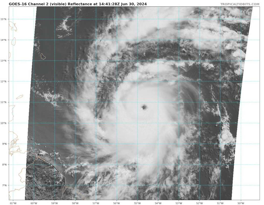
Data from the Air Force and NOAA Hurricane Hunters this morning
indicate that Beryl continues to rapidly intensify. Based on the
data collected, the minimum pressure has fallen significantly to
964 mb and the maximum wind speed is now up to 105 kt. Although
Beryl is still on the small side, the wind field is a little larger
than previously noted with the tropical-storm-force winds estimated
to extend up to 100 n mi from the center and hurricane-force winds
up to 25 n mi from the eye. Satellite images show that Beryl has a
classic major hurricane pattern with a clear and circular eye and
symmetric convective pattern surrounding it.

Beryl continues to move swiftly westward at 18 kt steered by a
strong subtropical ridge to its north. The hurricane has been
moving a little to the south of most of the model predictions over
the past day or two. A continued quick west to west-northwest
motion is forecast during the next several days as the ridge remains
the primary steering feature. This should take the core of Beryl
across the Windward Islands Monday morning and then across much the
Caribbean Sea during the following few days. The NHC track forecast
has been nudged to the south of the previous prediction and lies
close to the various consensus aids.

The major hurricane has rapidly intensified since it formed a
couple of days ago, and given the continued conducive environmental
conditions and compact inner core, it will likely strengthen some
more through tonight. Beryl is expected to be a very dangerous
category 4 hurricane when it moves through Windward Islands. The
models show a gradual increase in shear when the system moves
across the Caribbean Sea and that should cause Beryl's intensity to
level off and then gradually weaken. However, Beryl is expected to
remain a significant hurricane through the next 5 days. The
intensity forecast is a little above the previous one and in good
agreement with the HCCA and IVCN models.


Key Messages:

1. Beryl is expected to be an extremely dangerous Category 4
hurricane when it reaches the Windward Islands. This is a very
dangerous situation and residents in these areas should listen to
local government and emergency management officials for any
preparedness and/or evacuation orders. All preparations should be
rushed to completion today.

2. Potentially catastrophic hurricane-force winds, a
life-threatening storm surge, and damaging waves are expected
when Beryl passes over portions of the Windward Islands with the
highest risk of the core in St. Vincent and the Grenadines, and
Grenada beginning early Monday morning. Hurricane Warnings are in
effect for much of the Windward Islands.

3. Heavy rainfall and localized flooding are expected across the
Windward Islands through Monday.

4. Beryl is expected to remain a powerful hurricane as it moves
across the Caribbean Sea later this week and interests in
Hispaniola, Jamaica, the Cayman Islands and the remainder of the
northwestern Caribbean should monitor its progress, There is large
forecast uncertainty at days 4 and 5 and users should not focus on
the specific details of the track or intensity forecast.


FORECAST POSITIONS AND MAX WINDS

INIT 30/1500Z 10.7N 54.9W 105 KT 120 MPH
12H 01/0000Z 11.2N 57.5W 120 KT 140 MPH
24H 01/1200Z 12.1N 60.9W 120 KT 140 MPH
36H 02/0000Z 13.3N 64.3W 115 KT 130 MPH
48H 02/1200Z 14.6N 68.2W 115 KT 130 MPH
60H 03/0000Z 15.6N 72.1W 110 KT 125 MPH
72H 03/1200Z 16.4N 75.9W 105 KT 120 MPH
96H 04/1200Z 17.8N 82.8W 95 KT 110 MPH
120H 05/1200Z 19.2N 88.3W 75 KT 85 MPH...INLAND

$$
Forecaster Cangialosi
2 likes   
M a r k
- - - - -
Join us in chat: Storm2K Chatroom Invite. Android and IOS apps also available.

The posts in this forum are NOT official forecasts and should not be used as such. Posts are NOT endorsed by any professional institution or STORM2K.org. For official information and forecasts, please refer to NHC and NWS products.

User avatar
sponger
S2K Supporter
S2K Supporter
Posts: 1620
Joined: Thu Jul 22, 2004 11:26 am
Location: St Augustine

Re: ATL: BERYL - Hurricane - Discussion

#727 Postby sponger » Sun Jun 30, 2024 9:52 am

So, all the talk about the season shutting down for July due to SAL were incorrect. This is a good thing. Leaving the Atlantic to bake for another month would have been bad. A hurricanes job is to move heat and Beryll is doing its job. We have a lot of heat built up from the strong El Nino the last few years so every storm is going to make progress in bringing us back to normal levels.
6 likes   
The following post is NOT an official forecast and should not be used as such. It is just the opinion of the poster and may or may not be backed by sound meteorological data. It is NOT endorsed by any professional institution including storm2k.org For Official Information please refer to the NHC and NWS products.

User avatar
Teban54
Category 5
Category 5
Posts: 3169
Joined: Sat May 19, 2018 1:19 pm

Re: ATL: BERYL - Hurricane - Discussion

#728 Postby Teban54 » Sun Jun 30, 2024 9:58 am

0 likes   

User avatar
GCANE
S2K Supporter
S2K Supporter
Posts: 11453
Joined: Mon Oct 22, 2007 8:03 am

Re: ATL: BERYL - Hurricane - Discussion

#729 Postby GCANE » Sun Jun 30, 2024 10:02 am

RI usually leads to an EWRC in the short-term.
May see one within 24 hrs
1 likes   

User avatar
kevin
Category 5
Category 5
Posts: 2554
Age: 26
Joined: Wed Aug 28, 2019 4:35 am

Re: ATL: BERYL - Hurricane - Discussion

#730 Postby kevin » Sun Jun 30, 2024 10:04 am

Speechless... 960.6 mb, 126 kt FL, 132 kt SFMR. This is a cat 4.
6 likes   

User avatar
GCANE
S2K Supporter
S2K Supporter
Posts: 11453
Joined: Mon Oct 22, 2007 8:03 am

Re: ATL: BERYL - Hurricane - Discussion

#731 Postby GCANE » Sun Jun 30, 2024 10:05 am

GCANE wrote:RI usually leads to an EWRC in the short-term.
May see one within 24 hrs

Make that 12 hrs or less.
Just checked the latest drop and eye RH dropped from 99% to 58% at 850mb
Last edited by GCANE on Sun Jun 30, 2024 10:06 am, edited 1 time in total.
1 likes   

User avatar
TheWisestofAll
Tropical Low
Tropical Low
Posts: 21
Joined: Sun Dec 15, 2019 10:17 pm

Re: ATL: BERYL - Hurricane - Discussion

#732 Postby TheWisestofAll » Sun Jun 30, 2024 10:06 am

Correct me if I'm wrong, but I believe a track on the south side of guidance keeps it in favorable conditions longer, removing it further from potential tutt shear expected in a few days.
1 likes   

User avatar
kevin
Category 5
Category 5
Posts: 2554
Age: 26
Joined: Wed Aug 28, 2019 4:35 am

Re: ATL: BERYL - Hurricane - Discussion

#733 Postby kevin » Sun Jun 30, 2024 10:08 am

Blending SFMR & FL that latest pass supports 960 - 961 mb / 115 - 120 kt.
1 likes   

Charleswachal
S2K Supporter
S2K Supporter
Posts: 118
Age: 34
Joined: Tue Sep 27, 2022 11:24 pm

Re: ATL: BERYL - Hurricane - Discussion

#734 Postby Charleswachal » Sun Jun 30, 2024 10:08 am

Looks like aircraft date supports a cat 4 upgrade. Making a run for cat 5 by the end of the day barring any EWRC
0 likes   
Tropical Systems Experienced... Hurricane Harvey 2017 (Houston); Tropical Depression Imelda 2019 (Houston); Hurricane Nicolas 2021 (Houston), Hurricane Beryl 2024 (Eye Intercept)

User avatar
Teban54
Category 5
Category 5
Posts: 3169
Joined: Sat May 19, 2018 1:19 pm

Re: ATL: BERYL - Hurricane - Discussion

#735 Postby Teban54 » Sun Jun 30, 2024 10:10 am

kevin wrote:Blending SFMR & FL that latest pass supports 960 - 961 mb / 115 - 120 kt.

Any guesses on whether the NHC will issue a special advisory for a Cat 4 upgrade?
0 likes   

User avatar
Beef Stew
Category 1
Category 1
Posts: 496
Joined: Sat May 30, 2020 11:31 am
Location: South Florida

Re: ATL: BERYL - Hurricane - Discussion

#736 Postby Beef Stew » Sun Jun 30, 2024 10:10 am

I think with the most recent recon pass, 115kt is a reasonable estimate. Beryl appears to be a category 4.
0 likes   

User avatar
Hurricane2022
Category 5
Category 5
Posts: 1498
Joined: Tue Aug 23, 2022 11:38 pm
Location: Araçatuba, Brazil

Re: ATL: BERYL - Hurricane - Discussion

#737 Postby Hurricane2022 » Sun Jun 30, 2024 10:12 am

Getting some Delta '20 from this. 30 minutes after the upgrade to a 115 mph hurricane, the NHC made an update statement classifying it as a C4 hurricane (140 mph) :double:
0 likes   
Sorry for the bad English sometimes...!
For reliable and detailed information for any meteorological phenomenon, please consult the National Hurricane Center, Joint Typhoon Warning Center , or your local Meteo Center.

--------

Una cvm Christo, pro Christo, et in Christo. Sit nomen Domini benedictvm.

tolakram
Admin
Admin
Posts: 19990
Age: 61
Joined: Sun Aug 27, 2006 8:23 pm
Location: Florence, KY (name is Mark)

Re: ATL: BERYL - Hurricane - Discussion

#738 Postby tolakram » Sun Jun 30, 2024 10:12 am

latest
Image
9 likes   
M a r k
- - - - -
Join us in chat: Storm2K Chatroom Invite. Android and IOS apps also available.

The posts in this forum are NOT official forecasts and should not be used as such. Posts are NOT endorsed by any professional institution or STORM2K.org. For official information and forecasts, please refer to NHC and NWS products.

User avatar
Teban54
Category 5
Category 5
Posts: 3169
Joined: Sat May 19, 2018 1:19 pm

Re: ATL: BERYL - Hurricane - Discussion

#739 Postby Teban54 » Sun Jun 30, 2024 10:14 am

Image
3 likes   

tolakram
Admin
Admin
Posts: 19990
Age: 61
Joined: Sun Aug 27, 2006 8:23 pm
Location: Florence, KY (name is Mark)

Re: ATL: BERYL - Hurricane - Discussion

#740 Postby tolakram » Sun Jun 30, 2024 10:15 am

6 likes   
M a r k
- - - - -
Join us in chat: Storm2K Chatroom Invite. Android and IOS apps also available.

The posts in this forum are NOT official forecasts and should not be used as such. Posts are NOT endorsed by any professional institution or STORM2K.org. For official information and forecasts, please refer to NHC and NWS products.


Return to “2024”

Who is online

Users browsing this forum: No registered users and 53 guests