ATL: DEBBY - Post-Tropical - Discussion
Moderator: S2k Moderators
Re: ATL: DEBBY - Tropical Storm - Discussion
I'm a 2 decade old timer too. Weather geekery is a lifetime obsession. Used to visit CFHC and hurricane city alot back in the early years. I love our old, long time posters. Good friends I've never met but love reading their posts. Our formative system is large & loose and many be slow to tighten up but a 75-85mph cat 1 seems like a reasonable bet IMO. Mostly a heavy rain/freshwater flood event...perhaps even worse for GA and the Carolinas owing to slowing motion. Definitely some surge and beach erosion on the vulnerable west coast and some severe wx (tor risk) over the peninsula tonight and tomorrow...working into GA later. A real hose job from Brunswick GA to Brunswick County NC seems highly probable and very problematic. And this is just an early August appetizer. Pace yourselves gang...this season destined to age us old salts even more.
10 likes
-
cycloneye

- Admin

- Posts: 149504
- Age: 69
- Joined: Thu Oct 10, 2002 10:54 am
- Location: San Juan, Puerto Rico
Re: ATL: DEBBY - Tropical Storm - Discussion
New peak intensity is 75 kt before landfall.
FORECAST VALID 05/1200Z 29.3N 84.0W
MAX WIND 75 KT...GUSTS 90 KT.
64 KT... 15NE 15SE 10SW 10NW.
50 KT... 30NE 30SE 20SW 20NW.
34 KT... 70NE 120SE 70SW 40NW.
FORECAST VALID 05/1200Z 29.3N 84.0W
MAX WIND 75 KT...GUSTS 90 KT.
64 KT... 15NE 15SE 10SW 10NW.
50 KT... 30NE 30SE 20SW 20NW.
34 KT... 70NE 120SE 70SW 40NW.
2 likes
Visit the Caribbean-Central America Weather Thread where you can find at first post web cams,radars
and observations from Caribbean basin members Click Here
and observations from Caribbean basin members Click Here

Re: ATL: DEBBY - Tropical Storm - Discussion
psyclone wrote:I'm a 2 decade old timer too. Weather geekery is a lifetime obsession. Used to visit CFHC and hurricane city alot back in the early years. I love our old, long time posters. Good friends I've never met but love reading their posts. Our formative system is large & loose and many be slow to tighten up but a 75-85mph cat 1 seems like a reasonable bet IMO. Mostly a heavy rain/freshwater flood event...perhaps even worse for GA and the Carolinas owing to slowing motion. Definitely some surge and beach erosion on the vulnerable west coast and some severe wx (tor risk) over the peninsula tonight and tomorrow...working into GA later. A real hose job from Brunswick GA to Brunswick County NC seems highly probable and very problematic. And this is just an early August appetizer. Pace yourselves gang...this season destined to age us old salts even more.
Hitting things on the nose and for what they are. Always a favored poster fwiw
5 likes

Re: ATL: DEBBY - Tropical Storm - Discussion
psyclone wrote:I'm a 2 decade old timer too. Weather geekery is a lifetime obsession. Used to visit CFHC and hurricane city alot back in the early years. I love our old, long time posters. Good friends I've never met but love reading their posts. Our formative system is large & loose and many be slow to tighten up but a 75-85mph cat 1 seems like a reasonable bet IMO. Mostly a heavy rain/freshwater flood event...perhaps even worse for GA and the Carolinas owing to slowing motion. Definitely some surge and beach erosion on the vulnerable west coast and some severe wx (tor risk) over the peninsula tonight and tomorrow...working into GA later. A real hose job from Brunswick GA to Brunswick County NC seems highly probable and very problematic. And this is just an early August appetizer. Pace yourselves gang...this season destined to age us old salts even more.
That's a fact
6 likes
Andy D
(For official information, please refer to the NHC and NWS products.)
(For official information, please refer to the NHC and NWS products.)
-
HurricaneBelle

- S2K Supporter

- Posts: 1209
- Joined: Sun Aug 27, 2006 6:12 pm
- Location: Clearwater, FL
Re: ATL: DEBBY - Tropical Storm - Discussion
The new track is shifted slightly east and as a result there's been a huge jump in TS wind probabilities for the FL west coast.
These were the probabilities with the 5PM advisory:
TAMPA FL 34 1 11(12) 19(31) 7(38) 1(39) X(39) 2(41)
TAMPA FL 50 X X( X) 2( 2) 2( 4) X( 4) X( 4) X( 4)
CEDAR KEY FL 34 X 7( 7) 41(48) 16(64) 1(65) X(65) 1(66)
CEDAR KEY FL 50 X X( X) 6( 6) 10(16) 1(17) X(17) X(17)
CEDAR KEY FL 64 X X( X) 1( 1) 3( 4) X( 4) X( 4) X( 4)
And these are the probabilities at 11PM:
TAMPA FL 34 29 43(72) 11(83) 1(84) X(84) X(84) 1(85)
TAMPA FL 50 X 7( 7) 10(17) X(17) X(17) X(17) 1(18)
TAMPA FL 64 X X( X) 2( 2) X( 2) X( 2) X( 2) X( 2)
CEDAR KEY FL 34 6 55(61) 27(88) 1(89) X(89) X(89) X(89)
CEDAR KEY FL 50 X 5( 5) 39(44) 4(48) X(48) X(48) 1(49)
CEDAR KEY FL 64 X X( X) 11(11) 2(13) 1(14) X(14) X(14)
2 likes
-
weeniepatrol

- Category 5

- Posts: 1343
- Joined: Sat Aug 22, 2020 5:30 pm
- Location: WA State
Re: ATL: DEBBY - Tropical Storm - Discussion
Tropical Storm Debby Discussion Number 7
NWS National Hurricane Center Miami FL AL042024
1100 PM EDT Sat Aug 03 2024
NOAA and Air Force Reserve Hurricane Hunter aircraft have been
investigating Debby during the past few hours and have found that
the winds have increased slightly and the central pressure has
fallen. The NOAA P-3 plane reported SFMR measurements of 35-40 kt
east of the center over the Straits of Florida, and dropsonde data
indicate that the central pressure has fallen to 1003 mb. The
initial intensity is therefore raised to 40 kt.
Debby is gradually turning toward the right and slowing down, and
the initial motion is northwestward, or 320/12 kt. A large mid- to
upper-level trough over the eastern United States has created a
break in the subtropical ridge, which will cause Debby to move
northward over the eastern Gulf of Mexico and approach the
Florida Big Bend region over the next day or two. The track
guidance is in good agreement during this period, and the NHC track
has only been shifted slightly east to account for a slight
relocation of the initial position based on the aircraft data.
After 2-3 days, the steering currents around Debby collapse, and
the cyclone is expected to creep northeastward at less than 5 kt
across northern Florida to near the coasts of Georgia and South
Carolina by day 5. While there is model disagreement on exactly
where Debby will end up on day 5, there is high confidence that the
storm will not be moving very fast, and this slow motion will have
major implications for the associated hazards, particularly heavy
rainfall and flooding.
Low vertical shear and very warm waters (as warm as 32 degrees
Celsius within Apalachee Bay) are likely to support additional
strengthening while Debby approaches the Florida Big Bend. The
intensity guidance has increased a bit on this cycle. Most of the
regional hurricane models are showing Debby reaching hurricane
strength before it reaches the coast, while the
statistical-dynamical SHIPS and LGEM models have increased to the
75-80-kt range. In addition, the Rapid Intensification indices are
showing a 1-in-3 chance of a 45-kt increase in intensity over the
next 36 hours. Based on these model data, the NHC intensity
forecast has been increased to 75 kt in 36 hours, just before the
center of Debby is expected to reach the coast. Weakening is
anticipated after landfall, but Debby's intensity on days 3 through
5 is highly uncertain and is dependent on whether the center moves
over the Atlantic waters and for how long.
Emphasis mine
0 likes
-
MarioProtVI
- Category 5
- Posts: 1034
- Age: 24
- Joined: Sun Sep 29, 2019 7:33 pm
- Location: New Jersey
Re: ATL: DEBBY - Tropical Storm - Discussion
cycloneye wrote:New peak intensity is 75 kt before landfall.
FORECAST VALID 05/1200Z 29.3N 84.0W
MAX WIND 75 KT...GUSTS 90 KT.
64 KT... 15NE 15SE 10SW 10NW.
50 KT... 30NE 30SE 20SW 20NW.
34 KT... 70NE 120SE 70SW 40NW.
Seems to have gone with that because of the SHIPS. I don’t think a Cat 2 is out of the question here, especially if it gets cranking tomorrow.
4 likes
Re: ATL: DEBBY - Tropical Storm - Discussion
All I know is that Debby is one sloppy lady, but she's "large and in-charge". I doubt that I'll see the kind of gusts in Orlando that Ft. Lauderdale has received but I'm excited to get some training squalls ripping through here tomorrow night or Monday
1 likes
Andy D
(For official information, please refer to the NHC and NWS products.)
(For official information, please refer to the NHC and NWS products.)
-
cheezyWXguy

- Category 5
- Posts: 6282
- Joined: Mon Feb 13, 2006 12:29 am
- Location: Dallas, TX
Re: ATL: DEBBY - Tropical Storm - Discussion
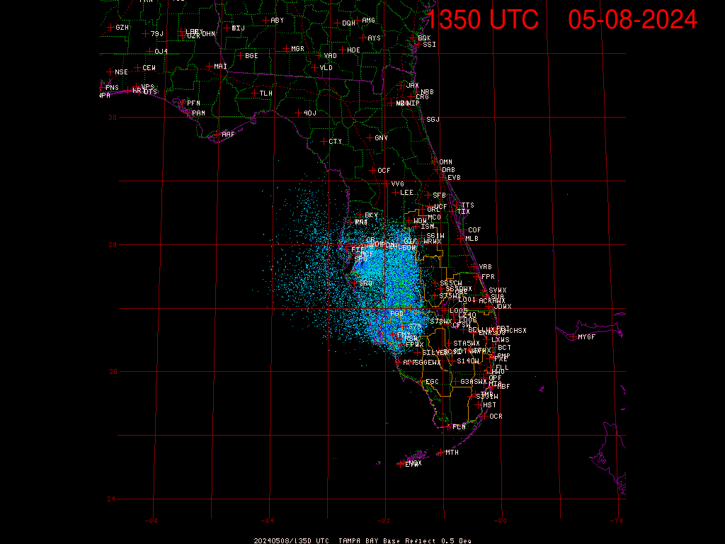
Radar suggests a new attempt at an inner core may be underway, with a band wrapping up the east side of the center. We’ll see if this one holds up
0 likes
-
eastcoastFL

- Category 5
- Posts: 3996
- Age: 44
- Joined: Thu Apr 12, 2007 12:29 pm
- Location: Palm City, FL
Re: ATL: DEBBY - Tropical Storm - Discussion
She’s starting to fill in nicely to the north of the center. This will probably be a very different looking storm tomorrow morning when people wake up.
1 likes
Personal Forecast Disclaimer:
The posts in this forum are NOT official forecast and should not be used as such. They are just the opinion of the poster and may or may not be backed by sound meteorological data. They are NOT endorsed by any professional institution or storm2k.org. For official information, please refer to the NHC and NWS products.
The posts in this forum are NOT official forecast and should not be used as such. They are just the opinion of the poster and may or may not be backed by sound meteorological data. They are NOT endorsed by any professional institution or storm2k.org. For official information, please refer to the NHC and NWS products.
-
eastcoastFL
- Category 5
- Posts: 3996
- Age: 44
- Joined: Thu Apr 12, 2007 12:29 pm
- Location: Palm City, FL
Re: ATL: DEBBY - Tropical Storm - Discussion
Very gusty squall coming through Stuart right now. The wind is howling for the first time today.
1 likes
Personal Forecast Disclaimer:
The posts in this forum are NOT official forecast and should not be used as such. They are just the opinion of the poster and may or may not be backed by sound meteorological data. They are NOT endorsed by any professional institution or storm2k.org. For official information, please refer to the NHC and NWS products.
The posts in this forum are NOT official forecast and should not be used as such. They are just the opinion of the poster and may or may not be backed by sound meteorological data. They are NOT endorsed by any professional institution or storm2k.org. For official information, please refer to the NHC and NWS products.
-
Hurricane Mike
- Category 2

- Posts: 675
- Joined: Tue Apr 10, 2018 7:44 am
Re: ATL: DEBBY - Tropical Storm - Discussion
11pm Video on Debby
https://www.youtube.com/watch?v=Fnu5ElrlhAo
https://www.youtube.com/watch?v=Fnu5ElrlhAo
1 likes
-
Poonwalker
- Category 1

- Posts: 270
- Joined: Tue Sep 20, 2022 11:12 am
Re: ATL: DEBBY - Tropical Storm - Discussion
Debbie hasn’t fully closed off yet on satellite or radar. Land proximity has been the likely deterrent so far from what I can tell. Not unusual to see repeated attempts in a fledgeling system before a true insulated core develops. The first indication will be a broadening and fluffy CDO on satellite. Not quite there yet on this one.
Last edited by Poonwalker on Sat Aug 03, 2024 10:36 pm, edited 1 time in total.
1 likes
-
SootyTern
- S2K Supporter
- Posts: 316
- Age: 57
- Joined: Sun Sep 05, 2004 5:09 pm
- Location: NYC (formerly Homestead, FL)
Re: ATL: DEBBY - Tropical Storm - Discussion
caneman wrote:Steve wrote:caneman wrote:
The Gulf this time of year I write of no possibilities!!! I mean none!
Yeah but the Gulf this time of year isn’t usually an issue. Btw always great to read your posts caneman. Not sure how many years we all have left but still.[/quote
Love ya Stevie. I think you me and Frank P and Sanibel are a few left overs from Central Florida Hurricane center. Not sure if I missed any? Please announce yourself if i missed you. This year just seems different. I know many here go off data, analytics, etc... I go off gut feel of living these things for 50 years. Take care my brother.
Went out on a Saturday night to go listen to some music and almost missed the reunion. I don't post much but I have been following along for 20 years on here and I also remember Steve and Frank P from CFHC. Y'all seem like old friends to me. It has also been fun to watch these smart kids join the forum and go on to great things. Good luck this season to all y'all!
4 likes
Disclaimer:
The posts in this forum are NOT official forecasts and should not be used as such. For official information, please refer to the NHC and NWS products.
Gulf Coast: Opal '95 Georges '98 / So Fla: Katrina '05 Wilma '05 Irma '17
The posts in this forum are NOT official forecasts and should not be used as such. For official information, please refer to the NHC and NWS products.
Gulf Coast: Opal '95 Georges '98 / So Fla: Katrina '05 Wilma '05 Irma '17
-
Hypercane_Kyle

- Category 5
- Posts: 3465
- Joined: Sat Mar 07, 2015 7:58 pm
- Location: Cape Canaveral, FL
Re: ATL: DEBBY - Tropical Storm - Discussion
Still broad on radar, as others have pointed out. A lot of convection starting to fire off the last few frames.

1 likes
My posts are my own personal opinion, defer to the National Hurricane Center (NHC) and other NOAA products for decision making during hurricane season.
-
cheezyWXguy
- Category 5
- Posts: 6282
- Joined: Mon Feb 13, 2006 12:29 am
- Location: Dallas, TX
Re: ATL: DEBBY - Tropical Storm - Discussion
Poonwalker wrote:Debbie hasn’t fully closed off yet on satellite or radar. Land proximity has been the likely deterrent so far from what I can tell. Not unusual to see repeated attempts in a fledgeling system before a true insulated core develops. The first indication will be a broadening and fluffy CDO on satellite. Not quite there yet on this one.
Land proximity hasn’t been an issue since it left Cuba this morning, it’s more just due to the fact that it’s been a broad circulation plagued with dry air since it came off Africa. A smaller more compact system would have wrapped up faster in the current environment, but also would have been more likely to dissipate prior to this point.
That said, it seems to be making a valiant attempt to make up for lost time at the moment. If these latest bursts over the center persist, the core should stack and allow for more notable intensification between now and landfall
5 likes
-
Hurricane2022

- Category 5
- Posts: 2039
- Joined: Tue Aug 23, 2022 11:38 pm
- Location: Araçatuba, Brazil
Re: ATL: DEBBY - Tropical Storm - Discussion
Cool

0 likes
Sorry for the bad English sometimes...!
For reliable and detailed information for any meteorological phenomenon, please consult the National Hurricane Center, Joint Typhoon Warning Center , or your local Meteo Center.
--------
ECCE OMNIA NOVA FACIAM (Ap 21,5).
For reliable and detailed information for any meteorological phenomenon, please consult the National Hurricane Center, Joint Typhoon Warning Center , or your local Meteo Center.
--------
ECCE OMNIA NOVA FACIAM (Ap 21,5).

Re: ATL: DEBBY - Tropical Storm - Discussion
Debby sure has that "look" to it, this is a tricky situation that can escalate quickly. Perhaps it is a 2024 trend we may be about to see, in which tropical systems organize quick and rapidly intensify from the get go, like what Beryl did. Those insane Gulf temps are a wildcard too. We'll be lucky if Debby hits as a Cat 1 or less.
The flood potential will be big too if she lollygags after landfall.
The flood potential will be big too if she lollygags after landfall.
1 likes
Georges '98, Irene '99, Frances '04, Jeanne '04, Katrina '05, Wilma '05, Gustav '08, Isaac '12, Matthew '16, Florence '18, Michael '18, Ian '22


-
Category5Kaiju

- Category 5
- Posts: 4334
- Joined: Thu Dec 24, 2020 12:45 pm
- Location: Seattle and Phoenix
Re: ATL: DEBBY - Tropical Storm - Discussion
Extremely warm water temperatures are a plus for Debby.
Deep layer shear is very light, so that's a plus for Debby.
Mid-level shear is also very light, so that's a plus for Debby.
There does not seem to be significant SAL or mid-level dry air nearby, so that's a plus for Debby.
I think the only thing that can be worked on is the structure of the storm itself.
1 likes
Unless explicitly stated, all info in my posts is based on my own opinions and observations. Tropical storms and hurricanes can be extremely dangerous. Refer to an accredited weather research agency or meteorologist if you need to make serious decisions regarding an approaching storm.
Who is online
Users browsing this forum: No registered users and 26 guests