
ATL: SARA - Models
Moderator: S2k Moderators
-
chris_fit

- Category 5

- Posts: 3261
- Age: 43
- Joined: Wed Sep 10, 2003 11:58 pm
- Location: Tampa Bay Area, FL
Re: ATL: INVEST 99L - Models
12z GFS caving to ICON so far? Much further W and S and weaker than previous run - so far.
1 likes
-
SouthFLTropics

- Category 5
- Posts: 4258
- Age: 50
- Joined: Thu Aug 14, 2003 8:04 am
- Location: Port St. Lucie, Florida
Re: ATL: INVEST 99L - Models
GFS going with the Mitch option, albeit much weaker, and dive bombing into Central America.
1 likes
Fourth Generation Florida Native
Personal Storm History: David 79, Andrew 92, Erin 95, Floyd 99, Irene 99, Frances 04, Jeanne 04, Wilma 05, Matthew 16, Irma 17, Ian 22, Nicole 22, Milton 24
Personal Storm History: David 79, Andrew 92, Erin 95, Floyd 99, Irene 99, Frances 04, Jeanne 04, Wilma 05, Matthew 16, Irma 17, Ian 22, Nicole 22, Milton 24


Re: ATL: INVEST 99L - Models
Yeah the Icon and CMC have been leading the way this year IMO and have been showing more entanglement and the GFS is moving toward that on the 12z. This is good news for Florida hopefully it continues to the Euro.
1 likes
The following post is NOT an official forecast and should not be used as such. It is just the opinion of the poster and may or may not be backed by sound meteorological data. It is NOT endorsed by any professional institution including storm2k.org For Official Information please refer to the NHC and NWS products.
-
toad strangler

- S2K Supporter

- Posts: 4546
- Joined: Sun Jul 28, 2013 3:09 pm
- Location: Earth
- Contact:
Re: ATL: INVEST 99L - Models
12z GFS says maybe Father climo coming home to roost?
0 likes
My Weather Station
https://www.wunderground.com/dashboard/pws/KFLPORTS603
https://www.wunderground.com/dashboard/pws/KFLPORTS603
-
AutoPenalti
- Category 5
- Posts: 4091
- Age: 29
- Joined: Mon Aug 17, 2015 4:16 pm
- Location: Ft. Lauderdale, Florida
Re: ATL: INVEST 99L - Models
GFS ever so slightly trending towards CA landfall and weakening, it was one of the possibilities since the beginning.
0 likes
The posts in this forum are NOT official forecasts and should not be used as such. They are just the opinion of the poster and may or may not be backed by sound meteorological data. They are NOT endorsed by any professional institution or STORM2K. For official information, please refer to products from the NHC and NWS.
Model Runs Cheat Sheet:
GFS (5:30 AM/PM, 11:30 AM/PM)
HWRF, GFDL, UKMET, NAVGEM (6:30-8:00 AM/PM, 12:30-2:00 AM/PM)
ECMWF (1:45 AM/PM)
TCVN is a weighted averaged
-
TampaWxLurker
- Tropical Storm

- Posts: 196
- Joined: Thu Aug 01, 2024 8:20 am
Re: ATL: INVEST 99L - Models
The new GFS scenario of the remnants post-Yucatan getting absorbed into the big cold front makes much more climo sense than a Cat 3 Hurricane hitting Florida in late November.
Let's hope it's correct.
Let's hope it's correct.
5 likes

Re: ATL: INVEST 99L - Models
So it is 1135est and ICON and GFS have the storm weakening to a disturbance after going ashore Yucatan. I am suspicous on just this last run of the gfs especially since prior had it going theu the Keys…and ones before anywhere from Naples to above Tampa.
1 likes

Re: ATL: INVEST 99L - Models
Encouraging outcome but It's only one run on the GFS. Let's see where the ensembles and Euro go next.
2 likes
-
AutoPenalti
- Category 5
- Posts: 4091
- Age: 29
- Joined: Mon Aug 17, 2015 4:16 pm
- Location: Ft. Lauderdale, Florida
Re: ATL: INVEST 99L - Models
GEFS still keeps majority of the members offshore.

2 likes
The posts in this forum are NOT official forecasts and should not be used as such. They are just the opinion of the poster and may or may not be backed by sound meteorological data. They are NOT endorsed by any professional institution or STORM2K. For official information, please refer to products from the NHC and NWS.
Model Runs Cheat Sheet:
GFS (5:30 AM/PM, 11:30 AM/PM)
HWRF, GFDL, UKMET, NAVGEM (6:30-8:00 AM/PM, 12:30-2:00 AM/PM)
ECMWF (1:45 AM/PM)
TCVN is a weighted averaged
-
toad strangler
- S2K Supporter
- Posts: 4546
- Joined: Sun Jul 28, 2013 3:09 pm
- Location: Earth
- Contact:
Re: ATL: INVEST 99L - Models
The 12z Euro never gets 99L cranking much before sending it into the Yucatan. Then pops out on the western most side of the northern peninsula where it is pulled NE through Florida a just N of Tampa and out at Daytona Beach. Could be a CAt 1 or so at FL landfall.
0 likes
My Weather Station
https://www.wunderground.com/dashboard/pws/KFLPORTS603
https://www.wunderground.com/dashboard/pws/KFLPORTS603
-
ConvergenceZone
.gif)
- Category 5
- Posts: 5241
- Joined: Fri Jul 29, 2005 1:40 am
- Location: Northern California
Re: ATL: INVEST 99L - Models
Feeling MUCH MUCH better today with the latest models. Yesterday was downright scary. What's happening today is what's expected with a developing system this late in the year.
1 likes
-
toad strangler
- S2K Supporter
- Posts: 4546
- Joined: Sun Jul 28, 2013 3:09 pm
- Location: Earth
- Contact:
Re: ATL: INVEST 99L - Models
12z EPS is extremely active with a plethora of weakish AND strong members. Almost all of them crossing the Yucatan and then turning NE landfalling the majority from the Big Bend of FL down to Sarasota.
0 likes
My Weather Station
https://www.wunderground.com/dashboard/pws/KFLPORTS603
https://www.wunderground.com/dashboard/pws/KFLPORTS603

Re: ATL: INVEST 99L - Models
hiflyer wrote:So it is 1135est and ICON and GFS have the storm weakening to a disturbance after going ashore Yucatan. I am suspicous on just this last run of the gfs especially since prior had it going theu the Keys…and ones before anywhere from Naples to above Tampa.
That just further leads me to be that much more wary of the GFS modeling. Kudos to it for consistently forecasting genesis however it has lately struggled with nearer term steering & possibly timing. The very fact that it's cycle to cycle changes ranging from the Keys, to Central West Florida coast, to Central America leads me to think that it is having some difficulties initially sniffing out atmospheric subtleties apt to impact steering (and intensity where land interaction is the result).
2 likes
Andy D
(For official information, please refer to the NHC and NWS products.)
(For official information, please refer to the NHC and NWS products.)
-
SFLcane

- S2K Supporter
- Posts: 10281
- Age: 48
- Joined: Sat Jun 05, 2010 1:44 pm
- Location: Lake Worth Florida
Re: ATL: INVEST 99L - Models
toad strangler wrote:12z EPS is extremely active with a plethora of weakish AND strong members. Almost all of them crossing the Yucatan and then turning NE landfalling the majority from the Big Bend of FL down to Sarasota.
Threat to the conus is greatly reduced now infact 18z intensity guidance mostly keep it below hurricane intensity. Not overly concern at all but could dump lots of rain over CA.
0 likes


Re: ATL: INVEST 99L - Models
SFLcane wrote:toad strangler wrote:12z EPS is extremely active with a plethora of weakish AND strong members. Almost all of them crossing the Yucatan and then turning NE landfalling the majority from the Big Bend of FL down to Sarasota.
Threat to the conus is greatly reduced now infact 18z intensity guidance mostly keep it below hurricane intensity. Not overly concern at all but could dump lots of rain over CA.
Keep in mind we are still 1 week out and models and ensembles flip all the time. Tomorrow most could show less time over land and a stronger solution.
3 likes
-
SFLcane
- S2K Supporter
- Posts: 10281
- Age: 48
- Joined: Sat Jun 05, 2010 1:44 pm
- Location: Lake Worth Florida
Re: ATL: INVEST 99L - Models
MetroMike wrote:SFLcane wrote:toad strangler wrote:12z EPS is extremely active with a plethora of weakish AND strong members. Almost all of them crossing the Yucatan and then turning NE landfalling the majority from the Big Bend of FL down to Sarasota.
Threat to the conus is greatly reduced now infact 18z intensity guidance mostly keep it below hurricane intensity. Not overly concern at all but could dump lots of rain over CA.
Keep in mind we are still 1 week out and models and ensembles flip all the time. Tomorrow most could show less time over land and a stronger solution.
Ridge has trended stronger today hence the models going into CA now.
0 likes

Re: ATL: INVEST 99L - Models
hard to bet against climo this time of year, definitely good news for florida as gfs has caved to the euro/cmc. blocking high just too strong
3 likes
-
Blown Away

- S2K Supporter
- Posts: 10253
- Joined: Wed May 26, 2004 6:17 am
Re: ATL: NINETEEN - Models
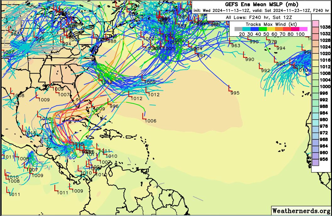
12z GEFS
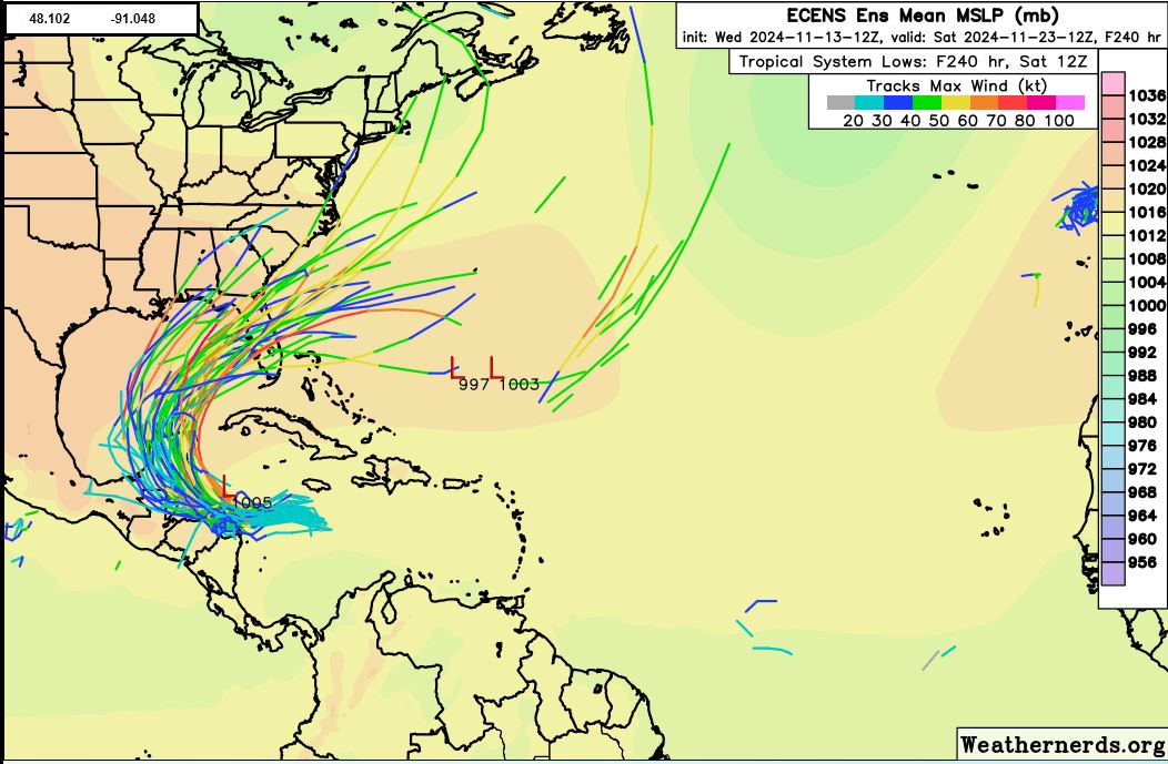
12z ECENS
Quite a spread, I suspect the end result will be something in between IMO...
0 likes
Hurricane Eye Experience: David 79, Irene 99, Frances 04, Jeanne 04, Wilma 05… Hurricane Brush Experience: Andrew 92, Erin 95, Floyd 99, Matthew 16, Irma 17, Ian 22, Nicole 22…
Who is online
Users browsing this forum: No registered users and 47 guests