ATL: MILTON - Post-Tropical - Discussion

Moderator: S2k Moderators

Message
Author
zzzh
Category 3
Category 3
Posts: 834
Joined: Thu Sep 02, 2021 1:13 pm

Re: ATL: MILTON - Hurricane - Discussion

#981 Postby zzzh » Sun Oct 06, 2024 8:32 pm

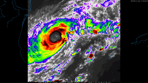
Travorum wrote:2nd Air Force pass VDM reports the eyewall has closed after that burst of convection north of the core.
URNT12 KNHC 070103
VORTEX DATA MESSAGE AL142024
A. 07/00:44:20Z
B. 22.53 deg N 093.32 deg W
C. 700 mb 2931 m
D. 980 mb
E. 085 deg 3 kt
F. CLOSED
G. C20
H. 66 kt
I. 025 deg 9 nm 00:42:00Z
J. 136 deg 70 kt
K. 036 deg 14 nm 00:40:30Z
L. 71 kt
M. 224 deg 12 nm 00:48:00Z
N. 314 deg 81 kt
O. 224 deg 12 nm 00:48:00Z
P. 10 C / 3047 m
Q. 15 C / 3048 m
R. 13 C / NA
S. 12345 / 07
T. 0.02 / 1.5 nm
U. AF302 0514A MILTON OB 14
MAX FL WIND 81 KT 224 / 12 NM 00:48:00Z
;

The VDM from 0123z shows
F. OPEN SE
G. C18
0 likes   

User avatar
eastcoastFL
Category 5
Category 5
Posts: 3901
Age: 43
Joined: Thu Apr 12, 2007 12:29 pm
Location: Palm City, FL

Re: ATL: MILTON - Hurricane - Discussion

#982 Postby eastcoastFL » Sun Oct 06, 2024 8:32 pm

cheezyWXguy wrote:
eastcoastFL wrote:The chart for the recon flight looks like it measured mslp sub 980 but the last center fix is 982mb with 9kts of wind. Has there been a recent reading I missed?

Extrapolated pressure isn’t perfect and usually reads a couple mb too low. Pressure is officially confirmed via dropsonde


I see there was a 977 in a VDM.
0 likes   
Personal Forecast Disclaimer:
The posts in this forum are NOT official forecast and should not be used as such. They are just the opinion of the poster and may or may not be backed by sound meteorological data. They are NOT endorsed by any professional institution or storm2k.org. For official information, please refer to the NHC and NWS products.

User avatar
Travorum
Category 1
Category 1
Posts: 406
Joined: Tue Sep 05, 2023 9:36 am
Location: Dunedin, FL

Re: ATL: MILTON - Hurricane - Discussion

#983 Postby Travorum » Sun Oct 06, 2024 8:35 pm

We're getting mixed returns on the status of the eyewall from both planes in Milton right now, as NOAA just reported the eyewall at 18nm and open to the SE. Given the small size of the core and rapid development this wouldn't be surprising, with convection blowing up around different quadrants it might take a bit for Milton to build a robust and stable eyewall.
1 likes   

Michele B
S2K Supporter
S2K Supporter
Posts: 1114
Joined: Thu Aug 25, 2016 8:08 am
Location: SWFL

Re: ATL: MILTON - Hurricane - Discussion

#984 Postby Michele B » Sun Oct 06, 2024 8:40 pm

FLpanhandle91 wrote:
chaser1 wrote:Contrary to present motion, the NE/ SW orientation of the overall envelope suggests to me that it's forward track should begin to start gaining a little latitude quite soon.


An often overlooked and very simple way to determine short-term storm direction. Follow the higher clouds in front of it. I wish I could find the clip of John Hope saying that.


Gosh, we miss his sage wisdom!
2 likes   
Cleo - 1964, Betsy - 1965, David - 1979, Andrew - 1992, Charlie (Francis, Ivan, Jeanne) - 2004, Irma - 2017, Ian - 2022

User avatar
WaveBreaking
Category 2
Category 2
Posts: 578
Joined: Sun Jun 30, 2024 11:33 am
Location: US

Re: ATL: MILTON - Hurricane - Discussion

#985 Postby WaveBreaking » Sun Oct 06, 2024 8:43 pm

Image
1 likes   
I am NOT a professional meteorologist, so take all of my posts with a grain of salt. My opinions are mine and mine alone.

User avatar
JaxGator
Category 2
Category 2
Posts: 780
Joined: Sun Jun 12, 2016 3:33 pm
Location: Jacksonville Florida

Re: ATL: MILTON - Hurricane - Discussion

#986 Postby JaxGator » Sun Oct 06, 2024 8:43 pm

Michele B wrote:
LandoWill wrote:5pm they actually didn't move the track much, if anything a little more south slightly


And I'm listening to Dr. Knabb on TWC right now, and he's saying they are now thinking the cold front that's digging in now and keeping Milton southerly will move out and he'll take a pretty sharp "left turn" and may end up much further north as it hits FL. Possibly near Cedar Key. They don't need that!


Ugh. That would be terrible for Cedar Key and points inland. One of my friends has been helping first responders and the National Guard with the clean up there (from Helene) and they have made good progress so far. They don’t need another repeat again. Glad Recon is currently in Milton now as he looks to having another episode of intensification. Watching closely.
0 likes   
The posts or stuff said are NOT an official forecast. Please look to the NHC and NWS for official forecasts and products.

Floyd-1999, Frances-2004, Jeanne-2004, Fay-2008, Beryl-2012, Debby-2012, Colin-2016, Hermine-2016, Julia-2016, Matthew-2016, Irma-2017, Elsa-2021, Idalia-2023, Debby-2024, Helene-2024.


Go Gators! Go Jags!

User avatar
gatorcane
S2K Supporter
S2K Supporter
Posts: 23691
Age: 47
Joined: Sun Mar 13, 2005 3:54 pm
Location: Boca Raton, FL

Re: ATL: MILTON - Hurricane - Discussion

#987 Postby gatorcane » Sun Oct 06, 2024 8:48 pm

Mandatory evacuations for Pasco County zones A and B:
https://www.tampabay.com/hurricane/2024 ... acuations/
0 likes   

Fancy1002
Tropical Storm
Tropical Storm
Posts: 135
Joined: Sun Dec 25, 2022 3:47 pm

Re: ATL: MILTON - Hurricane - Discussion

#988 Postby Fancy1002 » Sun Oct 06, 2024 8:50 pm

I expect to wake up tomorrow and either see a monstrous eye staring at me, or one well on its way to opening.
1 likes   

User avatar
Ptarmigan
Category 5
Category 5
Posts: 5313
Joined: Wed Aug 16, 2006 9:06 pm

Re: ATL: MILTON - Hurricane - Discussion

#989 Postby Ptarmigan » Sun Oct 06, 2024 8:55 pm

First Helene and now Milton. I would not be surprised if Milton becomes a Category 5 hurricane. :eek: :grr: :cry:
1 likes   

User avatar
eastcoastFL
Category 5
Category 5
Posts: 3901
Age: 43
Joined: Thu Apr 12, 2007 12:29 pm
Location: Palm City, FL

Re: ATL: MILTON - Hurricane - Discussion

#990 Postby eastcoastFL » Sun Oct 06, 2024 8:59 pm

ElectricStorm wrote:
eastcoastFL wrote:The chart for the recon flight looks like it measured mslp sub 980 but the last center fix is 982mb with 9kts of wind. Has there been a recent reading I missed?

There's two planes in there right now and the more recent of the two drops has 980mb


That was it. I was looking at two planes and didn't know.
0 likes   
Personal Forecast Disclaimer:
The posts in this forum are NOT official forecast and should not be used as such. They are just the opinion of the poster and may or may not be backed by sound meteorological data. They are NOT endorsed by any professional institution or storm2k.org. For official information, please refer to the NHC and NWS products.

User avatar
Travorum
Category 1
Category 1
Posts: 406
Joined: Tue Sep 05, 2023 9:36 am
Location: Dunedin, FL

Re: ATL: MILTON - Hurricane - Discussion

#991 Postby Travorum » Sun Oct 06, 2024 9:00 pm

SAR pass from about an hour ago, supports 80kts.

Image
Platform: RCM-2
Acquisition Date: 2024-10-07 00:22:41 UTC
Storm Name: AL142024 / MILTON
Storm ID: AL14
Storm Center Longitude: -93.366
Storm Center Latitude: 22.489
Incidence Angle (Degrees): 46.126
Quadrant 1 NE VMax (kts): 73.35
Quadrant 2 SE VMax (kts): 67.10
Quadrant 3 SW VMax (kts): 79.30
Quadrant 4 NW VMax (kts): 79.27
RMax (nmi): 10.00 - 13.00
8 likes   

User avatar
eastcoastFL
Category 5
Category 5
Posts: 3901
Age: 43
Joined: Thu Apr 12, 2007 12:29 pm
Location: Palm City, FL

Re: ATL: MILTON - Hurricane - Discussion

#992 Postby eastcoastFL » Sun Oct 06, 2024 9:01 pm

Travorum wrote:SAR pass from about an hour ago, supports 80kts.

https://i.imgur.com/fpxyMGo.png
Platform: RCM-2
Acquisition Date: 2024-10-07 00:22:41 UTC
Storm Name: AL142024 / MILTON
Storm ID: AL14
Storm Center Longitude: -93.366
Storm Center Latitude: 22.489
Incidence Angle (Degrees): 46.126
Quadrant 1 NE VMax (kts): 73.35
Quadrant 2 SE VMax (kts): 67.10
Quadrant 3 SW VMax (kts): 79.30
Quadrant 4 NW VMax (kts): 79.27
RMax (nmi): 10.00 - 13.00


They'll probably bump it up to 90mph at 11pm.
2 likes   
Personal Forecast Disclaimer:
The posts in this forum are NOT official forecast and should not be used as such. They are just the opinion of the poster and may or may not be backed by sound meteorological data. They are NOT endorsed by any professional institution or storm2k.org. For official information, please refer to the NHC and NWS products.

User avatar
cycloneye
Admin
Admin
Posts: 145362
Age: 68
Joined: Thu Oct 10, 2002 10:54 am
Location: San Juan, Puerto Rico

Re: ATL: MILTON - Hurricane - Discussion

#993 Postby cycloneye » Sun Oct 06, 2024 9:02 pm

3 likes   
Visit the Caribbean-Central America Weather Thread where you can find at first post web cams,radars
and observations from Caribbean basin members Click Here

User avatar
ElectricStorm
Category 5
Category 5
Posts: 5045
Age: 24
Joined: Tue Aug 13, 2019 11:23 pm
Location: Skiatook, OK / Norman, OK

Re: ATL: MILTON - Hurricane - Discussion

#994 Postby ElectricStorm » Sun Oct 06, 2024 9:04 pm

975.5mb extrap from NOAA plane
6 likes   
B.S Meteorology, University of Oklahoma '25

Please refer to the NHC, NWS, or SPC for official information.

User avatar
ElectricStorm
Category 5
Category 5
Posts: 5045
Age: 24
Joined: Tue Aug 13, 2019 11:23 pm
Location: Skiatook, OK / Norman, OK

Re: ATL: MILTON - Hurricane - Discussion

#995 Postby ElectricStorm » Sun Oct 06, 2024 9:19 pm

NOAA drop supports 978mb, down 2 mb from last drop a little over an hour ago
2 likes   
B.S Meteorology, University of Oklahoma '25

Please refer to the NHC, NWS, or SPC for official information.

zzzh
Category 3
Category 3
Posts: 834
Joined: Thu Sep 02, 2021 1:13 pm

Re: ATL: MILTON - Hurricane - Discussion

#996 Postby zzzh » Sun Oct 06, 2024 9:24 pm

F. OPEN NW
G. C17

Eye continues to contract. Pinhole eye is very likely.
2 likes   

User avatar
Hypercane_Kyle
Category 5
Category 5
Posts: 3352
Joined: Sat Mar 07, 2015 7:58 pm
Location: Cape Canaveral, FL

Re: ATL: MILTON - Hurricane - Discussion

#997 Postby Hypercane_Kyle » Sun Oct 06, 2024 9:26 pm

Fully expect this to be a Cat 2 by tomorrow AM.

Image
10 likes   
My posts are my own personal opinion, defer to the National Hurricane Center (NHC) and other NOAA products for decision making during hurricane season.

User avatar
StPeteMike
Category 2
Category 2
Posts: 631
Joined: Thu Jun 07, 2018 11:26 pm

Re: ATL: MILTON - Hurricane - Discussion

#998 Postby StPeteMike » Sun Oct 06, 2024 9:29 pm

Hypercane_Kyle wrote:Fully expect this to be a Cat 2 by tomorrow AM.

https://i.imgur.com/1TsuVJA.jpeg

Strong Cat 2 in the morning and Cat 3 by 2 pm, if it keeps this good structure going.
1 likes   
The above post is not official and should not be used as such. It is the opinion of the poster and may or may not be backed by sound meteorological data. It is not endorsed by any professional institution or storm2k.org. For official information, please refer to the NHC and NWS products.

User avatar
eastcoastFL
Category 5
Category 5
Posts: 3901
Age: 43
Joined: Thu Apr 12, 2007 12:29 pm
Location: Palm City, FL

Re: ATL: MILTON - Hurricane - Discussion

#999 Postby eastcoastFL » Sun Oct 06, 2024 9:32 pm

Hypercane_Kyle wrote:Fully expect this to be a Cat 2 by tomorrow AM.

https://i.imgur.com/1TsuVJA.jpeg


Same here, probably keep it a cat 1 at 11pm with 90mph but we will wake up to a CAT 2. These tiny storms can ramp up fast. They can also fall apart fast (fingers crossed).
1 likes   
Personal Forecast Disclaimer:
The posts in this forum are NOT official forecast and should not be used as such. They are just the opinion of the poster and may or may not be backed by sound meteorological data. They are NOT endorsed by any professional institution or storm2k.org. For official information, please refer to the NHC and NWS products.

User avatar
REDHurricane
Category 1
Category 1
Posts: 396
Age: 27
Joined: Sun Jul 03, 2022 2:36 pm
Location: Northeast Pacific Ocean

Re: ATL: MILTON - Hurricane - Discussion

#1000 Postby REDHurricane » Sun Oct 06, 2024 9:34 pm

Eyewall about to close off soon:

Image
1 likes   


Return to “2024”

Who is online

Users browsing this forum: Hypercane_Kyle and 10 guests