
ATL: DEBBY - Models
Moderator: S2k Moderators
-
cycloneye

- Admin

- Posts: 149682
- Age: 69
- Joined: Thu Oct 10, 2002 10:54 am
- Location: San Juan, Puerto Rico
ATL: DEBBY - Models
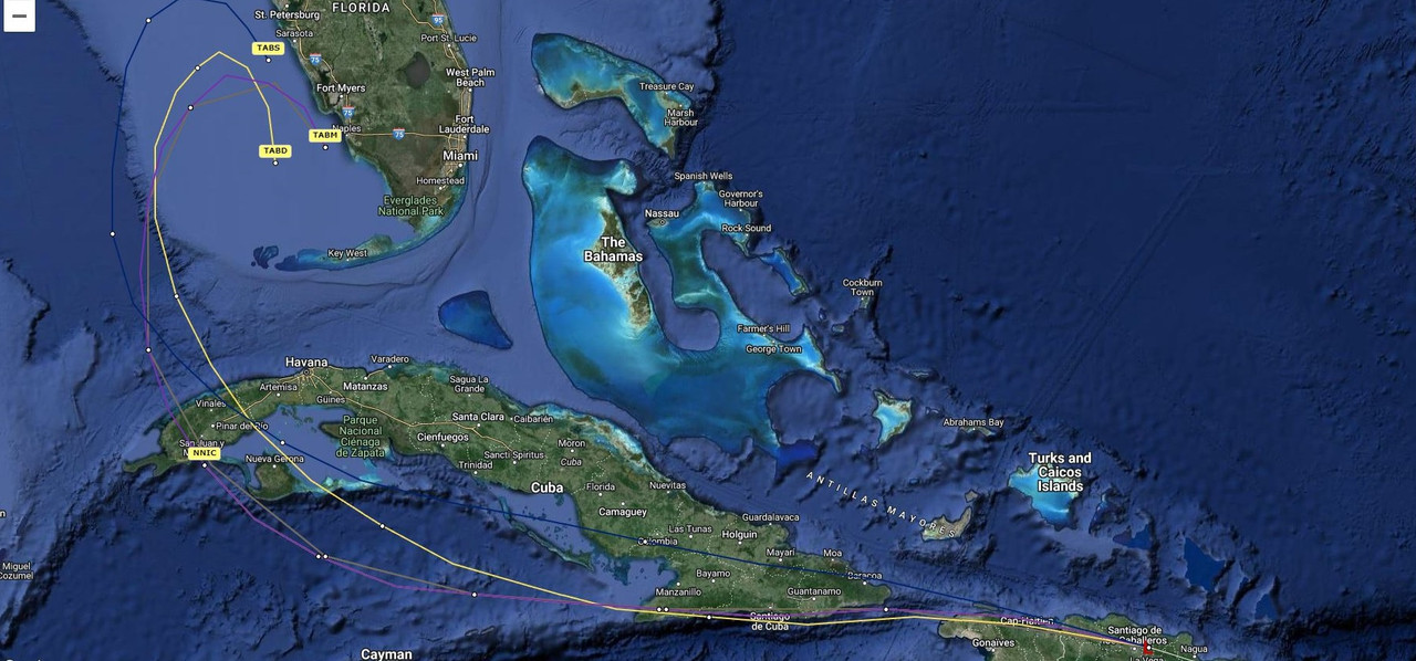
Only model runs.
1 likes
Visit the Caribbean-Central America Weather Thread where you can find at first post web cams,radars
and observations from Caribbean basin members Click Here
and observations from Caribbean basin members Click Here

-
cycloneye
- Admin
- Posts: 149682
- Age: 69
- Joined: Thu Oct 10, 2002 10:54 am
- Location: San Juan, Puerto Rico
Re: ATL: INVEST 97L - Models

3 likes
Visit the Caribbean-Central America Weather Thread where you can find at first post web cams,radars
and observations from Caribbean basin members Click Here
and observations from Caribbean basin members Click Here
-
DunedinDave
- Category 1

- Posts: 269
- Joined: Fri Aug 25, 2023 10:31 am
Re: ATL: INVEST 97L - Models
This reminds me a lot of Idalia last year in that I think it’s going to have a very short window to ramp up but even more disorganized. I don’t think this is anything until it gets north of Cuba. 06z Euro seems to turn this into nothing now.
I think we get a storm out of it but not sure anything more.
I think we get a storm out of it but not sure anything more.
0 likes
-
Category5Kaiju

- Category 5

- Posts: 4345
- Joined: Thu Dec 24, 2020 12:45 pm
- Location: Seattle during the summer, Phoenix during the winter
Re: ATL: INVEST 97L - Models
Wow, some of these model runs, assuming they were to verify, seem to want to pound Ian-affected areas with flooding.
1 likes
Unless explicitly stated, all information in my posts is based on my own opinions and observations. Tropical storms and hurricanes can be extremely dangerous. Refer to an accredited weather research agency or meteorologist if you need to make serious decisions regarding an approaching storm.
-
cycloneye
- Admin
- Posts: 149682
- Age: 69
- Joined: Thu Oct 10, 2002 10:54 am
- Location: San Juan, Puerto Rico
Re: ATL: INVEST 97L - Models
2 likes
Visit the Caribbean-Central America Weather Thread where you can find at first post web cams,radars
and observations from Caribbean basin members Click Here
and observations from Caribbean basin members Click Here

Re: ATL: INVEST 97L - Models
 Just another unknown caveat to throw into the mix of things. It might be interesting to see which (if any) models suggest faster development or RI in terms of how it might relate to the eventual storm track. Meaning, if there are already indications of a COL or short-term breakdown of steering in the S.E. GOM and any particular model suggest significant deepening to occur around that same time, such a quick fall in surface pressures could somewhat mitigate or at least further delay any onset of forward motion towards the projected weakness in the ridge. Such temporary stalls within quickly organizing systems can be apt to impact forecast point verification by hours. That might not seem like much, but it might just impact the timing 2-3 days later whether slipping through a weakness or just missing a retreating trough and getting blocked by the rebuilding ridge. Timing is everything but right now land will play the biggest factor there.
0 likes
Andy D
(For official information, please refer to the NHC and NWS products.)
(For official information, please refer to the NHC and NWS products.)
Re: ATL: INVEST 97L - Models
0 likes
Andy D
(For official information, please refer to the NHC and NWS products.)
(For official information, please refer to the NHC and NWS products.)
Re: ATL: INVEST 97L - Models
12z Icon again ignores the blocking high idea and plows through into the Atlantic... or so it seems.


well scratch that, it slows down here in this run and ultimately out to sea (safely away from Bermuda also). I don't think the icon does well with these type of scenarios and just may be playing slow catchup to other models here:

well scratch that, it slows down here in this run and ultimately out to sea (safely away from Bermuda also). I don't think the icon does well with these type of scenarios and just may be playing slow catchup to other models here:
Last edited by BobHarlem on Thu Aug 01, 2024 10:33 am, edited 3 times in total.
1 likes
-
Hurricaneman

- Category 5
- Posts: 7404
- Age: 45
- Joined: Tue Aug 31, 2004 3:24 pm
- Location: central florida
Re: ATL: INVEST 97L - Models
BobHarlem wrote:12z Icon again ignores the blocking high idea and plows through into the Atlantic... or so it seems.
https://i.imgur.com/PoayxmG.png
https://i.imgur.com/MNcuvAk.png
well scratch that, it stalls it out here:
https://i.imgur.com/LX3RX9n.png
Looks like the 6zGFS
0 likes
Re: ATL: INVEST 97L - Models
12Z GFS rolling...... Though subtle, I noticed that the 12Z Icon was a bit south and west of where the GFS (6Z) 12Z 8/5 forecast point was. I then took a quick look at the 12Z NAM to compare the short-wave position over Virginia compared to its earlier run. Seems to me that the trough is filling and pulling out a bit quicker. If that trend also applies to the GFS modeling than I'd anticipate GFS to have the storm a little south and/or west of its previous 6Z forecast for that (0Z 8/5) time. That would further make the argument for being trapped like a rat. Who knows, 12Z GFS might look similar to the BAM's with a Ft. Myers stall, or crossing the state further south and stalling south of Melbourne?
0 likes
Andy D
(For official information, please refer to the NHC and NWS products.)
(For official information, please refer to the NHC and NWS products.)
-
toad strangler

- S2K Supporter

- Posts: 4546
- Joined: Sun Jul 28, 2013 3:09 pm
- Location: Earth
- Contact:
Re: ATL: INVEST 97L - Models
12z GFS passes very close to Tampa heading N and strengthening @70 hours and LANDFALL at the Suwanne River area at 85 hours CRAWLING NNE
Last edited by toad strangler on Thu Aug 01, 2024 10:57 am, edited 1 time in total.
0 likes
My Weather Station
https://www.wunderground.com/dashboard/pws/KFLPORTS603
https://www.wunderground.com/dashboard/pws/KFLPORTS603


-
toad strangler
- S2K Supporter
- Posts: 4546
- Joined: Sun Jul 28, 2013 3:09 pm
- Location: Earth
- Contact:
Re: ATL: INVEST 97L - Models
12z GFS @101 hours is nearly stalled in extreme SE GA
0 likes
My Weather Station
https://www.wunderground.com/dashboard/pws/KFLPORTS603
https://www.wunderground.com/dashboard/pws/KFLPORTS603
Re: ATL: INVEST 97L - Models
Category5Kaiju wrote:Wow, some of these model runs, assuming they were to verify, seem to want to pound Ian-affected areas with flooding.
So much riding on the steering currents.
Even if it doens't intensify much beyond a TS or Cat 1 (or 2), if it lingers over SW FL, or loops back toward us, yeah, those of us who were under Ian will see LOTS and LOTS of rain. I'm not personally in a flood prone area, but closer to the coast, folks are. That won't be fun. They'll have to evacuate, even if it isn't a full-blown hurricane.
That tends to create problems, but cause people hesitate to evacuate. They forget "hide from wind, run from water."
0 likes
Cleo - 1964, Betsy - 1965, David - 1979, Andrew - 1992, Charlie (Francis, Ivan, Jeanne) - 2004, Irma - 2017, Ian - 2022, Milton - 2024

Re: ATL: INVEST 97L - Models
Any time the models show that it will enter the GOM this time of year, I get nervous in the Houston area. My damage from Beryl should be completed this weekend, but I had to spend the money that I had saved up for a generator on my deductible. Strong -removed- going on at my house lol.
0 likes
Alicia, Rita, Ike, Harvey and Beryl...moved to Splendora lol
Re: ATL: INVEST 97L - Models
Over water again, moving very slowly off Brunswick, GA/St. Simons Island

Last edited by BobHarlem on Thu Aug 01, 2024 11:06 am, edited 1 time in total.
0 likes
Re: ATL: INVEST 97L - Models
So far, the 12Z GFS is pretty much smack on top of its 6Z position forecast times
0 likes
Andy D
(For official information, please refer to the NHC and NWS products.)
(For official information, please refer to the NHC and NWS products.)
Who is online
Users browsing this forum: No registered users and 77 guests