ATL: MILTON - Post-Tropical - Discussion

Moderator: S2k Moderators

Message
Author
User avatar
cycloneye
Admin
Admin
Posts: 143855
Age: 68
Joined: Thu Oct 10, 2002 10:54 am
Location: San Juan, Puerto Rico

ATL: MILTON - Post-Tropical - Discussion

#1 Postby cycloneye » Fri Oct 04, 2024 6:41 pm

AL, 92, 2024100500, , BEST, 0, 220N, 955W, 25, 0, DB, 0, , 0, 0, 0, 0, 1011, 180, 60, 0, 0, L, 0, , 0, 0, GENESIS028, , 0, , 0, 0, 0, 0, genesis-num, 028, SPAWNINVEST, al712024 to al922024,


https://ftp.nhc.noaa.gov/atcf/btk/bal922024.dat

Image
1 likes   
Visit the Caribbean-Central America Weather Thread where you can find at first post web cams,radars
and observations from Caribbean basin members Click Here

Tailgater33
Tropical Depression
Tropical Depression
Posts: 78
Joined: Thu Jun 02, 2022 9:15 am

Re: ATL: INVEST 92L - Discussion

#2 Postby Tailgater33 » Fri Oct 04, 2024 6:45 pm

This looks like it will become a named system pretty quick, this area spins them up
.
2 likes   

User avatar
chaser1
S2K Supporter
S2K Supporter
Posts: 5406
Age: 64
Joined: Sat Oct 15, 2005 5:59 pm
Location: Longwood, Fl

Re: ATL: INVEST 92L - Discussion

#3 Postby chaser1 » Fri Oct 04, 2024 6:46 pm

Boom, there it is (not too sure on the 22.0 though LOL?)
1 likes   
Andy D

(For official information, please refer to the NHC and NWS products.)

skillz305
Category 1
Category 1
Posts: 277
Joined: Sat Sep 08, 2018 11:10 am
Location: Miami, Florida --> Vero Beach, Florida

Re: ATL: INVEST 92L - Discussion

#4 Postby skillz305 » Fri Oct 04, 2024 7:05 pm

Well... welcome my Florida folks. Be on the look out. :flag:
5 likes   
:flag:Hurricanes: Andrew 1992 - Irene 1999 - Frances 2004 - Jeanne 2004 - Katrina 2005 - Wilma 2005 - Matthew 2016 - Irma 2017 - Ian 2022 - Nicole 2022

User avatar
Weatherboy1
Category 5
Category 5
Posts: 1189
Age: 49
Joined: Mon Jul 05, 2004 1:50 pm
Location: Jupiter/Sarasota, FL

Re: ATL: INVEST 92L - Discussion

#5 Postby Weatherboy1 » Fri Oct 04, 2024 7:12 pm

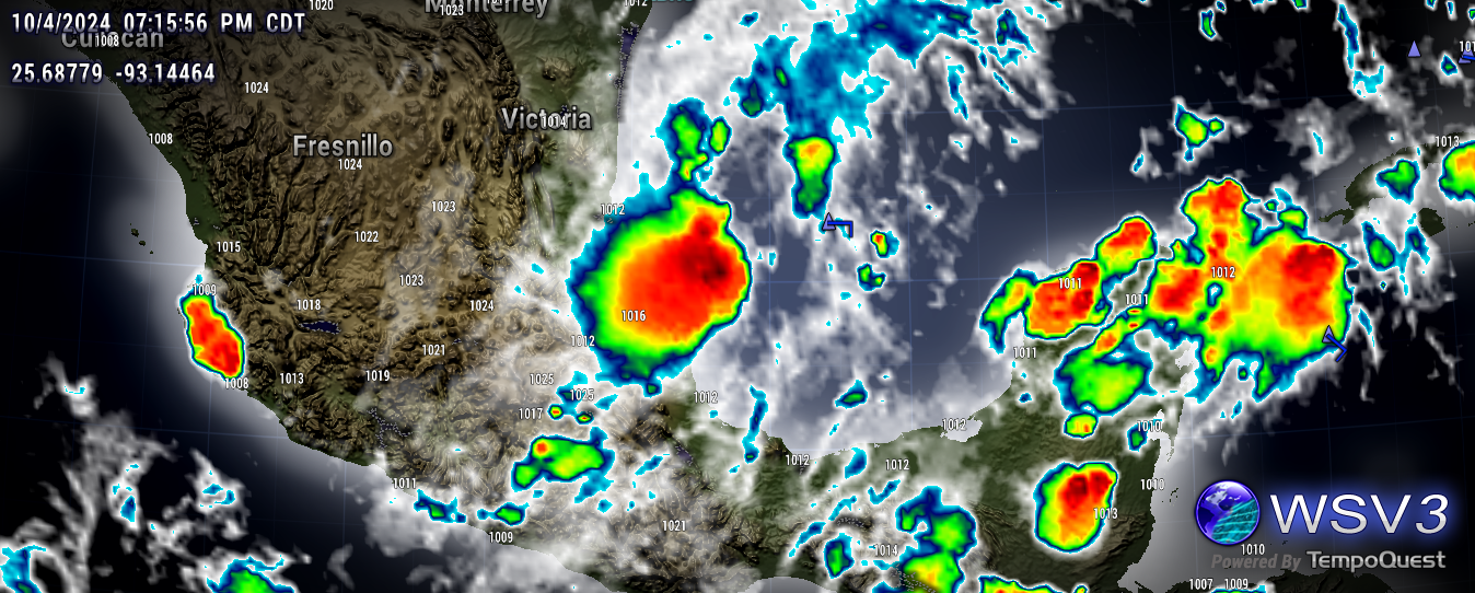
Yeah that ball of convection has looked real interesting for a few hours…and could be spinning up into something. Question is - what exactly? And how strong will it get?
2 likes   

User avatar
tropicwatch
Category 5
Category 5
Posts: 3364
Age: 61
Joined: Sat Jun 02, 2007 10:01 am
Location: Panama City Florida
Contact:

Re: ATL: INVEST 92L - Discussion

#6 Postby tropicwatch » Fri Oct 04, 2024 7:19 pm

Pressures in the area near the convection are running 1010 - 1012mb and Buoy 42055 east of the convection is reporting 1010.7mb

Image
2 likes   
Tropicwatch


Agnes 72', Eloise 75, Elena 85', Kate 85', Charley 86', Florence 88', Beryl 94', Dean 95', Erin 95', Opal 95', Earl 98', Georges 98', Ivan 2004', Arlene 2005', Dennis 2005', Ida 2009' Debby 2012' Irma 2017' Michael 2018'

grapealcoholic
Category 2
Category 2
Posts: 684
Joined: Tue Aug 10, 2021 3:26 pm

Re: ATL: INVEST 92L - Discussion

#7 Postby grapealcoholic » Fri Oct 04, 2024 7:21 pm

92L might put on a show tonight
2 likes   

User avatar
Nimbus
Category 5
Category 5
Posts: 5274
Joined: Mon Jul 19, 2004 10:54 am

Re: ATL: INVEST 92L - Discussion

#8 Postby Nimbus » Fri Oct 04, 2024 7:30 pm

Should start getting some hurricane model runs soon.
Need to have landfall predictions by Monday.
3 likes   

User avatar
StPeteMike
Category 2
Category 2
Posts: 622
Joined: Thu Jun 07, 2018 11:26 pm

Re: ATL: INVEST 92L - Discussion

#9 Postby StPeteMike » Fri Oct 04, 2024 7:35 pm

The waters under 92L are the warmest in the Gulf of Mexico. If a storm was looking for an area to really ramp up, this storm has found the location.
1 likes   
The above post is not official and should not be used as such. It is the opinion of the poster and may or may not be backed by sound meteorological data. It is not endorsed by any professional institution or storm2k.org. For official information, please refer to the NHC and NWS products.

User avatar
aspen
Category 5
Category 5
Posts: 8812
Joined: Sat Oct 12, 2019 7:10 pm
Location: Connecticut, USA

Re: ATL: INVEST 92L - Discussion

#10 Postby aspen » Fri Oct 04, 2024 7:38 pm

Oh great, another one. I was hoping this disturbance would fizzle out when models started down trending a few days ago.

On the bright side, it is unlikely to have anywhere close to the same scale of impacts as Helene.
2 likes   
Irene '11 Sandy '12 Hermine '16 5/15/2018 Derecho Fay '20 Isaias '20 Elsa '21 Henri '21 Ida '21

I am only a meteorology enthusiast who knows a decent amount about tropical cyclones. Look to the professional mets, the NHC, or your local weather office for the best information.

Stormlover70
Tropical Storm
Tropical Storm
Posts: 167
Age: 55
Joined: Fri Jun 21, 2024 5:31 am
Location: New port richey

Re: ATL: INVEST 92L - Discussion

#11 Postby Stormlover70 » Fri Oct 04, 2024 7:43 pm

StPeteMike wrote:The waters under 92L are the warmest in the Gulf of Mexico. If a storm was looking for an area to really ramp up, this storm has found the location.
warm water alone doesn't make a system.
0 likes   

User avatar
Category5Kaiju
Category 5
Category 5
Posts: 4051
Joined: Thu Dec 24, 2020 12:45 pm
Location: Seattle

Re: ATL: INVEST 92L - Discussion

#12 Postby Category5Kaiju » Fri Oct 04, 2024 7:47 pm

Oh wow, I've been basically sleeping on this system with tracking Kirk and Leslie, but it's very interesting that its development chances skyrocketed. Seems to have decent convection right now. Low deep layer wind shear and very warm Gulf waters at the moment.

Hmm.....this system will be interesting to watch.
2 likes   
Unless explicitly stated, all info in my posts is based on my own opinions and observations. Tropical storms and hurricanes can be extremely dangerous. Do not think you can beat Mother Nature. Refer to an accredited weather research agency or meteorologist if you need to make serious decisions regarding an approaching storm.

zzzh
Category 3
Category 3
Posts: 833
Joined: Thu Sep 02, 2021 1:13 pm

Re: ATL: INVEST 92L - Discussion

#13 Postby zzzh » Fri Oct 04, 2024 8:16 pm

* GFS version *
* ATLANTIC 2024 SHIPS INTENSITY FORECAST *
* IR SAT DATA AVAILABLE, OHC AVAILABLE *
* INVEST AL922024 10/05/24 00 UTC *

TIME (HR) 0 6 12 18 24 36 48 60 72 84 96 108 120 132 144 156 168
V (KT) NO LAND 25 26 28 31 34 40 46 53 58 60 63 66 66 67 67 67 66
V (KT) LAND 25 26 28 31 34 40 46 53 58 47 39 42 42 39 35 39 38
V (KT) LGEM 25 26 27 28 30 33 37 41 45 40 35 38 41 39 38 42 41
Storm Type TROP TROP TROP TROP TROP TROP TROP TROP TROP TROP TROP TROP TROP TROP TROP TROP TROP

SHEAR (KT) 5 11 10 9 10 9 13 10 9 7 7 5 12 11 19 22 32
SHEAR ADJ (KT) 1 0 -2 -1 2 0 5 0 2 3 2 3 6 0 0 5 9
SHEAR DIR 172 187 219 231 238 230 194 210 205 152 172 194 201 177 185 259 243
SST (C) 31.2 31.2 31.1 31.0 31.0 31.2 31.3 31.1 31.0 31.0 30.6 30.8 30.9 30.4 30.3 29.8 29.5
POT. INT. (KT) 169 169 168 167 167 168 169 170 172 172 172 172 172 172 171 166 160
200 MB T (C) -51.7 -51.9 -52.0 -51.8 -51.6 -51.8 -51.5 -52.1 -51.6 -52.2 -51.8 -52.2 -51.9 -52.0 -52.2 -52.5 -53.1
200 MB VXT (C) 0.5 0.6 0.5 0.4 0.4 0.3 0.2 0.4 0.3 0.5 0.6 0.4 0.5 0.0 0.0 0.0 0.0
TH_E DEV (C) 7 5 4 7 8 6 9 6 8 7 10 9 9 8 7 5 4
700-500 MB RH 77 77 76 76 74 69 68 67 64 61 52 49 49 48 47 48 48
MODEL VTX (KT) 7 6 6 9 9 11 12 16 17 18 19 18 16 LOST LOST LOST LOST
850 MB ENV VOR 70 59 52 41 31 28 37 51 54 71 95 100 97 89 65 20 -11
200 MB DIV 51 49 40 34 23 8 40 18 25 22 0 -2 0 19 19 23 62
700-850 TADV 6 7 1 0 0 0 -3 -2 -3 -1 0 2 4 -1 -3 13 5
LAND (KM) 194 191 190 179 190 230 284 349 175 -70 30 119 57 21 -14 189 403
LAT (DEG N) 22.0 22.4 22.8 23.0 23.2 23.1 22.6 21.8 21.1 20.4 20.2 20.7 21.7 xx.x xx.x xx.x xx.x
LONG(DEG W) 95.5 95.7 95.9 96.0 95.9 95.5 94.8 93.8 92.1 89.8 87.1 84.5 82.0 xxx.x xxx.x xxx.x xxx.x
STM SPEED (KT) 4 4 3 2 2 2 5 7 10 12 12 13 13 12 10 10 9
HEAT CONTENT 45 48 50 50 52 52 49 41 36 20 63 109 92 78 72 59 47

The environment is surprisingly good.
1 likes   

mantis83
Tropical Storm
Tropical Storm
Posts: 198
Joined: Fri Dec 05, 2003 4:47 pm

Re: ATL: INVEST 92L - Discussion

#14 Postby mantis83 » Fri Oct 04, 2024 8:17 pm

Looks to be encountering some easterly shear, should keep it in check for now
0 likes   

User avatar
REDHurricane
Category 1
Category 1
Posts: 394
Age: 27
Joined: Sun Jul 03, 2022 2:36 pm
Location: Northeast Pacific Ocean

Re: ATL: INVEST 92L - Discussion

#15 Postby REDHurricane » Fri Oct 04, 2024 8:31 pm

mantis83 wrote:Looks to be encountering some easterly shear, should keep it in check for now


Ehhhh not really:

Image
3 likes   

User avatar
tropicwatch
Category 5
Category 5
Posts: 3364
Age: 61
Joined: Sat Jun 02, 2007 10:01 am
Location: Panama City Florida
Contact:

Re: ATL: INVEST 92L - Discussion

#16 Postby tropicwatch » Fri Oct 04, 2024 8:54 pm

REDHurricane wrote:
mantis83 wrote:Looks to be encountering some easterly shear, should keep it in check for now


Ehhhh not really:

https://i.ibb.co/Y7pKKqj/92-L-SHHEHAR.gif

Already has a ventilation setup.
0 likes   
Tropicwatch


Agnes 72', Eloise 75, Elena 85', Kate 85', Charley 86', Florence 88', Beryl 94', Dean 95', Erin 95', Opal 95', Earl 98', Georges 98', Ivan 2004', Arlene 2005', Dennis 2005', Ida 2009' Debby 2012' Irma 2017' Michael 2018'

User avatar
TampaBayBee
S2K Supporter
S2K Supporter
Posts: 36
Joined: Tue Aug 31, 2004 3:16 pm

Re: ATL: INVEST 92L - Discussion

#17 Postby TampaBayBee » Fri Oct 04, 2024 8:58 pm

Florida Gulf Coast watching Wx after another long day of cleanup. Covered the flood debris mountain with tarps this afternoon. Received local alert that sandbags are available beginning 0700 tomorrow with heavy rains predicted. Not much left to lose around here except time for cleanup and recovery from Helene. 8-)
2 likes   

User avatar
chaser1
S2K Supporter
S2K Supporter
Posts: 5406
Age: 64
Joined: Sat Oct 15, 2005 5:59 pm
Location: Longwood, Fl

Re: ATL: INVEST 92L - Discussion

#18 Postby chaser1 » Fri Oct 04, 2024 9:08 pm

TampaBayBee wrote:Florida Gulf Coast watching Wx after another long day of cleanup. Covered the flood debris mountain with tarps this afternoon. Received local alert that sandbags are available beginning 0700 tomorrow with heavy rains predicted. Not much left to lose around here except time for cleanup and recovery from Helene. 8-)


That just sucks. I'm sorry you're dealing with that.
5 likes   
Andy D

(For official information, please refer to the NHC and NWS products.)

User avatar
Buck
S2K Supporter
S2K Supporter
Posts: 1172
Joined: Fri Sep 10, 2004 12:04 pm
Location: Atlanta, GA

Re: ATL: INVEST 92L - Discussion

#19 Postby Buck » Fri Oct 04, 2024 9:11 pm

I had an Uncle Milton, he was a nice guy…
1 likes   

User avatar
Soluna16
Tropical Low
Tropical Low
Posts: 35
Joined: Sun Sep 22, 2024 9:30 pm

Re: ATL: INVEST 92L - Discussion

#20 Postby Soluna16 » Fri Oct 04, 2024 9:59 pm

Seeing these intensities slowly creep up living in central florida :double:
1 likes   
Hurricane Experience: Charley 2004, Frances 2004, Jeanne 2004, Matthew 2016, Irma 2017, Dorian 2019, Ian 2022, Nicole 2022, Helene 2024, Milton 2024


Return to “2024”

Who is online

Users browsing this forum: No registered users and 13 guests