
ATL: OSCAR - Models
Moderator: S2k Moderators
ATL: OSCAR - Models
These are probably overcooked, but just putting it out here.
2 likes
TC naming lists: retirements and intensity
Most aggressive Advisory #1's in North Atlantic (cr. kevin for starting the list)
Most aggressive Advisory #1's in North Atlantic (cr. kevin for starting the list)
-
cycloneye

- Admin

- Posts: 149669
- Age: 69
- Joined: Thu Oct 10, 2002 10:54 am
- Location: San Juan, Puerto Rico
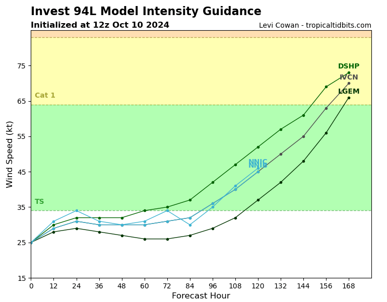
Re: ATL: INVEST 94L - Models
00z European moves it all the way to north of Dominican Republic.

0 likes
Visit the Caribbean-Central America Weather Thread where you can find at first post web cams,radars
and observations from Caribbean basin members Click Here
and observations from Caribbean basin members Click Here

Re: ATL: INVEST 94L - Models
00z Euro, we could be tracking this one for a while. Most members eventually do develop this and make it a decent TS or at most a low-end hurricane. And of course there is one Euro member that decides we need an Irma-repeat, in October.

4 likes
Re: ATL: INVEST 94L - Models
kevin wrote:00z Euro, we could be tracking this one for a while. Most members eventually do develop this and make it a decent TS or at most a low-end hurricane. And of course there is one Euro member that decides we need an Irma-repeat, in October.
https://i.imgur.com/ICg0Kvm.png
Considering that the time frame in which EPS shows this is quite similar to when GFS and its ensembles show the Caribbean-Gulf system, would it be an either-or situation where significant development of one system would preclude the other or keep it weak? Or could this end up being another Irma-Jose scenario (with hopefully lower intensities)?
0 likes
TC naming lists: retirements and intensity
Most aggressive Advisory #1's in North Atlantic (cr. kevin for starting the list)
Most aggressive Advisory #1's in North Atlantic (cr. kevin for starting the list)
Re: ATL: INVEST 94L - Models
Still very preliminary since we don't have a TC yet, but the 06z GEFS shows a more pronounced SW dip over the coming days than the previous GEFS ensembles. Reminiscent of Irma's SW dip (not implying that this system will be close in intensity to that monster), which would increase the risk for land impacts somewhere down the line.

0 likes
-
USTropics
- Professional-Met

- Posts: 2739
- Joined: Sun Aug 12, 2007 3:45 am
- Location: Florida State University
Re: ATL: INVEST 94L - Models
Ya know, just your standard African Easterly Wave traversing the entire Atlantic into the Caribbean during the middle of October (  ):
):

6 likes

Re: ATL: INVEST 94L - Models
Just really took notice of this fella (or lassie if I'm presumptive this is future Nadine) for the first time since the Milton commotion. Mostly I noticed how far west it is going and that in this run of the Euro it is going wsw albeit weakening.
In the setup above why would it not follow the stream of low pressure to its NE? Is that not a trough? I'm new to the forum is there a thread dedicated to meteorological theory questions? I had some notions about steering patterns that have been proven strikingly wrong. I'm a novice, meteorology fan and would love to know more from this great community.
In the setup above why would it not follow the stream of low pressure to its NE? Is that not a trough? I'm new to the forum is there a thread dedicated to meteorological theory questions? I had some notions about steering patterns that have been proven strikingly wrong. I'm a novice, meteorology fan and would love to know more from this great community.
0 likes
-
cycloneye
- Admin
- Posts: 149669
- Age: 69
- Joined: Thu Oct 10, 2002 10:54 am
- Location: San Juan, Puerto Rico
Re: ATL: INVEST 94L - Models
USTropics wrote:Ya know, just your standard African Easterly Wave traversing the entire Atlantic into the Caribbean during the middle of October (
https://i.imgur.com/zIQBwAf.gif
Almost same track as Euro.
0 likes
Visit the Caribbean-Central America Weather Thread where you can find at first post web cams,radars
and observations from Caribbean basin members Click Here
and observations from Caribbean basin members Click Here
Re: ATL: INVEST 94L - Models
GFS,EC, CMC, ICON all agree on some development as it crosses 60W. Will it enter the Caribbean and will the west Caribbean system develop and induce shear over it?
0 likes
-
WaveBreaking

- Category 2

- Posts: 727
- Joined: Sun Jun 30, 2024 11:33 am
- Location: US
Re: ATL: INVEST 94L - Models
jjoslin wrote:Just really took notice of this fella (or lassie if I'm presumptive this is future Nadine) for the first time since the Milton commotion. Mostly I noticed how far west it is going and that in this run of the Euro it is going wsw albeit weakening.
https://imgur.com/dSRtkCN
In the setup above why would it not follow the stream of low pressure to its NE? Is that not a trough? I'm new to the forum is there a thread dedicated to meteorological theory questions? I had some notions about steering patterns that have been proven strikingly wrong. I'm a novice, meteorology fan and would love to know more from this great community.
That large area of high pressure to the north is the main reason why. It’s imparting northeasterly flow on the storm which limits its ability to move to the east. However the storm does start to slow down and change direction at the end of the run, so you are right in that the front would influence the storm to track to the northeast. Also 500 mbar plots from that model run show a trough exiting the US at 240 hours, which would definitely guide the system to the northeast.
0 likes
I am NOT a professional meteorologist, so take all of my posts with a grain of salt. My opinions are mine and mine alone.


-
gatorcane

- S2K Supporter

- Posts: 23708
- Age: 48
- Joined: Sun Mar 13, 2005 3:54 pm
- Location: Boca Raton, FL
Re: ATL: INVEST 94L - Models
Latest EC-AIFS bring this all the way into the NW Caribbean with development as does the GFS and CMC, hard to believe but here is the loop:

3 likes
-
Hypercane_Kyle

- Category 5

- Posts: 3465
- Joined: Sat Mar 07, 2015 7:58 pm
- Location: Cape Canaveral, FL
Re: ATL: INVEST 94L - Models
gatorcane wrote:Latest EC-AIFS bring this all the way into the NW Caribbean with development as does the GFS and CMC, hard to believe but here is the loop:
https://i.postimg.cc/LswVXNc9/ec-aifs-mslp-pcpn-atl-fh6-240.gif
Yeah, a lot of the models have actually been hinting at this. The Canadian had it too, briefly.
1 likes
My posts are my own personal opinion, defer to the National Hurricane Center (NHC) and other NOAA products for decision making during hurricane season.

Re: ATL: INVEST 94L - Models
Not the Irma WSW bend...
0 likes
Igor 2010, Sandy 2012, Fay 2014, Gonzalo 2014, Joaquin 2015, Nicole 2016, Humberto 2019, Imelda 2025
I am only a tropical weather enthusiast. My predictions are not official and may or may not be backed by sound meteorological data. For official information, please refer to the NHC and NWS products.
I am only a tropical weather enthusiast. My predictions are not official and may or may not be backed by sound meteorological data. For official information, please refer to the NHC and NWS products.
-
Hurricane2022

- Category 5
- Posts: 2084
- Joined: Tue Aug 23, 2022 11:38 pm
- Location: Araçatuba, Brazil
Re: ATL: INVEST 94L - Models
kevin wrote:00z Euro, we could be tracking this one for a while. Most members eventually do develop this and make it a decent TS or at most a low-end hurricane. And of course there is one Euro member that decides we need an Irma-repeat, in October.
https://i.imgur.com/ICg0Kvm.png
Any news about the 00z Euro today?

0 likes
Sorry for the bad English sometimes...!
For reliable and detailed information for any meteorological phenomenon, please consult the National Hurricane Center, Joint Typhoon Warning Center , or your local Meteo Center.
--------
ECCE OMNIA NOVA FACIAM (Ap 21,5).
For reliable and detailed information for any meteorological phenomenon, please consult the National Hurricane Center, Joint Typhoon Warning Center , or your local Meteo Center.
--------
ECCE OMNIA NOVA FACIAM (Ap 21,5).
-
cycloneye
- Admin
- Posts: 149669
- Age: 69
- Joined: Thu Oct 10, 2002 10:54 am
- Location: San Juan, Puerto Rico
Re: ATL: INVEST 94L - Models
Can't post graphic as is for subscribers but 12z Euro has a cat 2 from 94L in NW Caribbean.
2 likes
Visit the Caribbean-Central America Weather Thread where you can find at first post web cams,radars
and observations from Caribbean basin members Click Here
and observations from Caribbean basin members Click Here
-
ColdMiser123

- Professional-Met
- Posts: 905
- Age: 29
- Joined: Mon Sep 26, 2016 3:26 pm
- Location: Northeast US
Re: ATL: INVEST 94L - Models
12z Euro has a hurricane in the NW Caribbean at the end of its run. Worth watching.
0 likes
B.S., M.S., Meteorology & Atmospheric Science
-
AnnularCane

- S2K Supporter
- Posts: 2964
- Joined: Thu Jun 08, 2006 9:18 am
- Location: Wytheville, VA
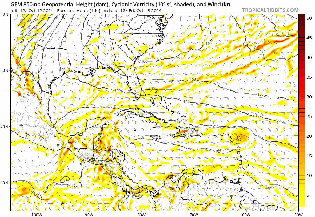
Re: ATL: INVEST 94L - Models
gatorcane wrote:12Z CMC:
https://i.postimg.cc/7hkYPgTZ/gem-z850-vort-watl-fh144-240.gif
Well hello there...
Sneaky little thing.
0 likes
"But it never rained rain. It never snowed snow. And it never blew just wind. It rained things like soup and juice. It snowed mashed potatoes and green peas. And sometimes the wind blew in storms of hamburgers." -- Judi Barrett, Cloudy with a Chance of Meatballs


Who is online
Users browsing this forum: No registered users and 77 guests