ATL: Ex-INVEST 91L - Models
Moderator: S2k Moderators
-
otowntiger
- Category 5

- Posts: 1932
- Joined: Tue Aug 31, 2004 7:06 pm
Re: ATL: INVEST 91L - Models
Looks like GFS now swings it sharply OTS after hitting the northern Leewards and PR as a cat 1, while Euro kills it off and ensembles are unimpressed for the most part it seems.
0 likes
-
Hypercane_Kyle

- Category 5
- Posts: 3465
- Joined: Sat Mar 07, 2015 7:58 pm
- Location: Cape Canaveral, FL
Re: ATL: INVEST 91L - Models
All models will be useless until this thing detaches from the monsoon trough. Euro solution of no development seems unlikely.
0 likes
My posts are my own personal opinion, defer to the National Hurricane Center (NHC) and other NOAA products for decision making during hurricane season.


Re: ATL: INVEST 91L - Models
IcyTundra wrote:chaser1 wrote:I wonder where the models will take 91L once initialized up around 14N? I'll say this much; Should that be verified at first light tomorrow morning (12Z), then I would suspect a quicker spin up to a T.D AND a pretty quick upgrade to T.S. The added couple of degrees distance between itself and the weak low to its southwest would probably mitigate low level convergence issues as well.
I haven't looked at the satellite imagery today but I'm guessing that you have. Are you seeing something that makes you think that the models are intializing the center too far south?
Yes, from the visible floater (prior to dusk of course) and well as IR enhancement it apparent "to me" that the broader LLC has in fact reorganized to the north and would would appear to be under the more vigorous MLC. I would have projected the center to be very close to 14.1N on visible; Perhaps closer to 13.8N based on IR (but that of course is difficult at night and given that it may be tucked more directly under the CDO).
That is what I am speculating to have occurred but was hopeful that other trained eyes might add their .02 cents worth as well.
0 likes
Andy D
(For official information, please refer to the NHC and NWS products.)
(For official information, please refer to the NHC and NWS products.)


Re: ATL: INVEST 91L - Models
For the record, today’s 12Z JMA moves much more quickly as it gets near Bermuda at 192! What’s up with that? This is actually consistent with yesterday’s 12Z JMA.
0 likes
Personal Forecast Disclaimer:
The posts in this forum are NOT official forecasts and should not be used as such. They are just the opinion of the poster and may or may not be backed by sound meteorological data. They are NOT endorsed by any professional institution or storm2k.org. For official information, please refer to the NHC and NWS products.
The posts in this forum are NOT official forecasts and should not be used as such. They are just the opinion of the poster and may or may not be backed by sound meteorological data. They are NOT endorsed by any professional institution or storm2k.org. For official information, please refer to the NHC and NWS products.
-
Stratton23
- Category 5
- Posts: 3575
- Joined: Fri Jul 21, 2023 10:59 pm
- Location: Katy, Tx
Re: ATL: INVEST 91L - Models
Im not really that sure the JMA is that reliable though, i certainly haven’t really heard that model being talked about alot outside of MJO forecasting
0 likes
Re: ATL: INVEST 91L - Models
18Z EPS has less members developing than the 12Z but the ones that do develop are further south.
0 likes
Re: ATL: INVEST 91L - Models
Stratton23 wrote:Im not really that sure the JMA is that reliable though, i certainly haven’t really heard that model being talked about alot outside of MJO forecasting
Yeah, it’s not that reliable. But it’s had its great moments like it did with Beryl last year. It along with the Icon was insisting on an upper TX to SW LA hit very early on unlike the GFS, Euro, and CMC.
0 likes
Personal Forecast Disclaimer:
The posts in this forum are NOT official forecasts and should not be used as such. They are just the opinion of the poster and may or may not be backed by sound meteorological data. They are NOT endorsed by any professional institution or storm2k.org. For official information, please refer to the NHC and NWS products.
The posts in this forum are NOT official forecasts and should not be used as such. They are just the opinion of the poster and may or may not be backed by sound meteorological data. They are NOT endorsed by any professional institution or storm2k.org. For official information, please refer to the NHC and NWS products.
Re: ATL: INVEST 91L - Models
0z Icon ends with eyewall over Antigua and Barbuda. Left and faster than the 12z, roughly the same intensity.

0 likes
-
ScottNAtlanta

- Category 5
- Posts: 2535
- Joined: Sat May 25, 2013 3:11 pm
- Location: Atlanta, GA
Re: ATL: INVEST 91L - Models
The JMA does really well with the MJO. Most of the dynamical MJO modelling is headed to phases 1 and 2 which are favoured phases for the Atlantic to spit out storms. They all are fairly weak into 1 and 2 but experience says they usually correct stronger into these phases.
The JMA below is pretty representative of the others too
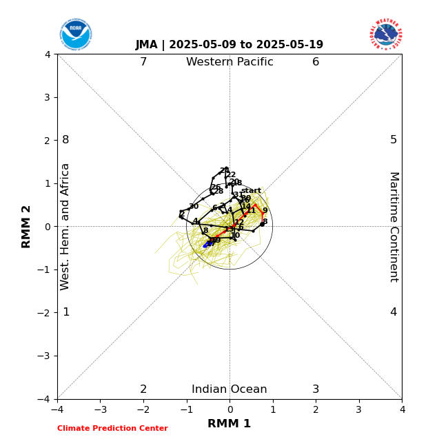
The JMA below is pretty representative of the others too
4 likes
The posts in this forum are NOT official forecast and should not be used as such. They are just the opinion of the poster and may or may not be backed by sound meteorological data. They are NOT endorsed by any professional institution or storm2k.org. For official information, please refer to the NHC and NWS products.
-
Stratton23
- Category 5
- Posts: 3575
- Joined: Fri Jul 21, 2023 10:59 pm
- Location: Katy, Tx
Re: ATL: INVEST 91L - Models
Are my eyes deceiving me or is the 00z GFS trying to develop two different systems out of 91L? This run through 42 hours so far looks very very weird
0 likes

Re: ATL: INVEST 91L - Models
Stratton23 wrote:Are my eyes deceiving me or is the 00z GFS trying to develop two different systems out of 91L? This run through 42 hours so far looks very very weird
I only see one to my untrained eye but the system is considerably south compared to the 18z and 12z run so far through 80 hours. It’s almost off the Pivotal west Atlantic map on the bottom of the map lol
0 likes
Re: ATL: INVEST 91L - Models
Stratton23 wrote:Are my eyes deceiving me or is the 00z GFS trying to develop two different systems out of 91L? This run through 42 hours so far looks very very weird
Yes, it's very obvious on the 850 vorticity charts. Tropical Storm Emily back in 2011 had the same twin competing low thing, and it never really got going. (emily was one of the longest running "dud" threads on here) It got together right before the shredder in Hispaniola, started to regenerate then hit a wall of shear and died out in the Bahamas. Models had it a big threat to the east coast running up to that before hand.
Last edited by BobHarlem on Thu Sep 04, 2025 11:05 pm, edited 4 times in total.
0 likes
Re: ATL: INVEST 91L - Models
LAF92 wrote:Stratton23 wrote:Are my eyes deceiving me or is the 00z GFS trying to develop two different systems out of 91L? This run through 42 hours so far looks very very weird
I only see one to my untrained eye but the system is considerably south compared to the 18z and 12z run so far through 80 hours. It’s almost off the Pivotal west Atlantic map on the bottom of the map lol
Yeah it is all the way down below 11 N on the 0Z GFS. I believe the ICON is forecasting 91L to lose a bit of latitude as well.
0 likes

Re: ATL: INVEST 91L - Models
The 0Z UKMET is again too weak with the low to classify it as a TD.
0 likes
Personal Forecast Disclaimer:
The posts in this forum are NOT official forecasts and should not be used as such. They are just the opinion of the poster and may or may not be backed by sound meteorological data. They are NOT endorsed by any professional institution or storm2k.org. For official information, please refer to the NHC and NWS products.
The posts in this forum are NOT official forecasts and should not be used as such. They are just the opinion of the poster and may or may not be backed by sound meteorological data. They are NOT endorsed by any professional institution or storm2k.org. For official information, please refer to the NHC and NWS products.
Re: ATL: INVEST 91L - Models
Definitely looks like the anemic ensembles were on to something, considering we're trending towards them and not the other way around. Hoping this trend continues for our friends in the Leewards (or at this rate, the Windwards).
0 likes
Re: ATL: INVEST 91L - Models
One thing I am noticing on this run is that the ULL to the north of the LA is much stronger on this run. Seems like 91L is far enough to the south to avoid getting completely sheared by it.
1 likes
-
cheezyWXguy

- Category 5
- Posts: 6282
- Joined: Mon Feb 13, 2006 12:29 am
- Location: Dallas, TX
Re: ATL: INVEST 91L - Models
BobHarlem wrote:Stratton23 wrote:Are my eyes deceiving me or is the 00z GFS trying to develop two different systems out of 91L? This run through 42 hours so far looks very very weird
Yes, it's very obvious on the 850 vorticity charts. Tropical Storm Emily back in 2011 had the same twin competing low thing, and it never really got going. (emily was one of the longest running "dud" threads on here) It got together right before the shredder in Hispaniola, started to regenerate then hit a wall of shear and died out in the Bahamas. Models had it a big threat to the east coast running up to that before hand.
Isaias and Laura in 2020 had similar competing areas of vorticity in their formative stages in this area as well, but I’m not sold that’s accurate for 91L. I’ve noticed at times over the years that sometimes the gfs is wrong when it depicts this, and 91L seems to be more compact than either of the 2 examples I mentioned. Unless other models are showing this, I’m skeptical for now.
0 likes
Who is online
Users browsing this forum: No registered users and 44 guests