A bit late, but 6z model intensities of
94L:
HAFS-A Parent (initialized on Humberto):
- Peak: 982 mb / 111 hrs
- Stalls offshore GA/SC, Fujiwhara with Humberto
HAFS-A (initialized on 94L):
- Peak: 982 mb / 75 kt (Cat 1) / 108 hrs
- Landfall near GA/SC border (very slightly weakened)
HAFS-B Parent (initialized on Humberto):
- Peak: 975 mb / 102 hrs
- Stalls north of the Bahamas, Fujiwhara with Humberto
HAFS-B (initialized on 94L):
- Peak: 978 mb / 67 kt (Cat 1) / 111 hrs
- Landfall near GA/SC border (very slightly weakened)
HWRF Parent (initialized on Humberto):
- Peak: Unclear, likely Cat 1/2 around 980 mb
- Landfall near SC/NC border
HWRF (initialized on 94L):
- Peak: 964 mb / 103 kt (Cat 3) / 108 hrs
- Landfall in Wilmington, NC at peak intensity
HMON:
- Peak: 981 mb / 80 kt (Cat 1) / 108 hrs -- this frame is already inland, so peak wind could be higher
- Landfall in Georgetown, SC at peak intensity
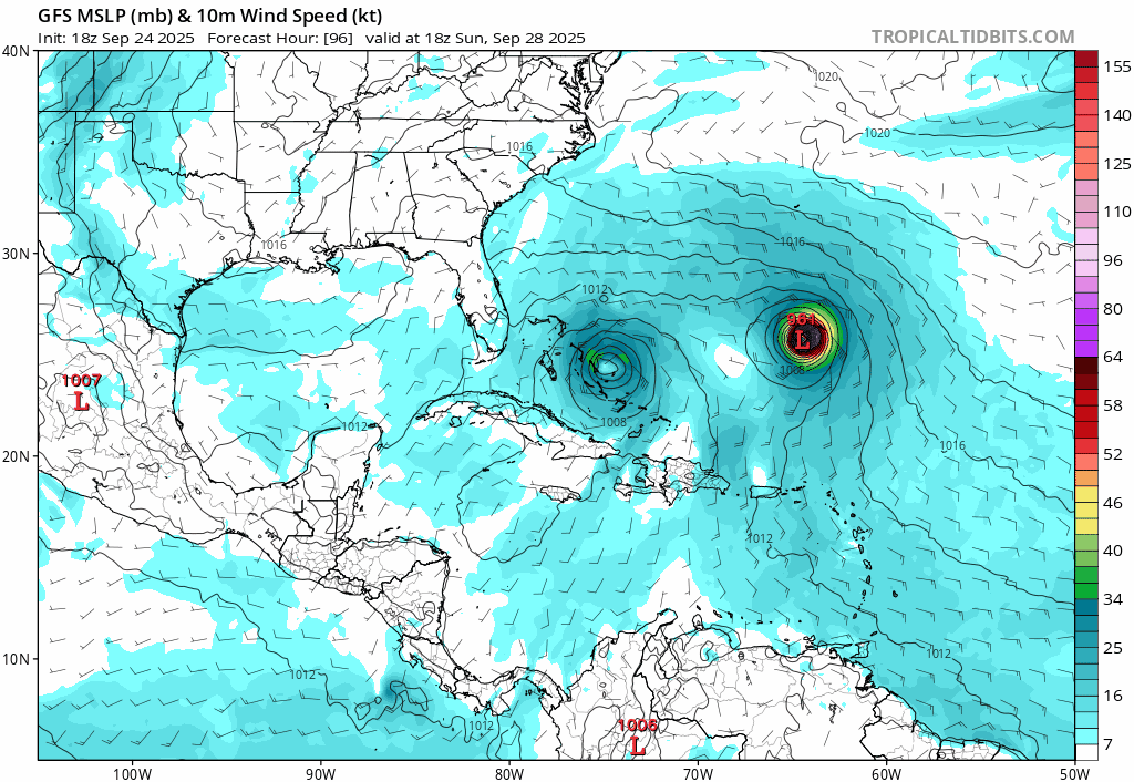
GFS:
- Peak: 980s / 126 hrs
- Landfall in Charleston, SC at peak intensity
ECMWF:
- Peak: 980s / 120 hrs
- Landfall just west of Charleston, SC at peak intensity
Assuming that hurricane models initialized on storm X has a better handle of X itself than the other storm Y, some observations (especially viewed together with
the Humberto runs):
- A Cat 1 landfall somewhere in GA/SC/NC, especially SC, seems very likely
- The models that go higher (HWRF-94L) are likely underestimating Humberto. A stronger Humberto may limit 94L's potential to become a MH.
- 94L may stall either just before or after landfall -- flooding may be a bigger threat than wind speed alone
The posts in this forum are NOT official forecasts and should not be used as such. They are just the opinion of the poster and may or may not be backed by sound meteorological data. They are NOT endorsed by any professional institution or
STORM2K. For official information, please refer to products from the
NHC and
NWS.


