NATL: HUMBERTO - Models
Moderator: S2k Moderators
-
MEANINGLESS_NUMBERS
- Category 2

- Posts: 503
- Joined: Mon Nov 02, 2020 1:43 pm
Re: NATL: HUMBERTO - Models
Looks like yet another major hurricane will shoot the gap between NC and Bermuda. Close calls from majors Erin, Gabrielle, and hopefully now Humberto. How many times will we get lucky this season?
0 likes
Emily '87, Felix '95, Gert '99, Fabian '03, Humberto '19, Paulette '20, Teddy '20, Fiona '22, Lee '23, Ernesto '24, Humberto/Imelda '25

Re: NATL: HUMBERTO - Models
It's amazing how quiet this thread is given that some hurricane models (and even global models) have Humberto as low as the 920s... But not surprising.
4 likes
TC naming lists: retirements and intensity
Most aggressive Advisory #1's in North Atlantic (cr. kevin for starting the list)
Most aggressive Advisory #1's in North Atlantic (cr. kevin for starting the list)
-
TomballEd
- Category 5

- Posts: 1332
- Age: 62
- Joined: Wed Aug 16, 2023 4:52 pm
- Location: Spring/Klein area, not Tomball
Re: NATL: HUMBERTO - Models
Looks like Euro ensembles like a US landfall, most from 94L but a few Humberto's as well.

0 likes
Re: NATL: HUMBERTO - Models
A bit late, but 6z model intensities of Humberto:
HAFS-A (initialized on Humberto):
Assuming that hurricane models initialized on storm X has a better handle of X itself than the other storm Y, some observations (especially viewed together with the 94L runs):
HAFS-A (initialized on Humberto):
- Peak: 957 mb / 119 kt (Cat 4) / 84 hrs
- Weakens to TS/C1 at the end of the run, due to Fujiwhara with 94L
- Peak: 958 mb / 87 hrs
- Weakens to C1 at the end of the run, but no Fujiwhara
- Peak: 960 mb / 117 kt (Cat 4) / 84 hrs
- Weakens to C1 at the end of the run, due to Fujiwhara with 94L
- Peak: 953 mb or lower / 66+ hrs
- (Loses track at the end of the run, may continue strengthening after)
- Peak: 935 mb / 135 kt (Cat 4) / 81-87 hrs
- Weakens to C3 at the end of the run, but no Fujiwhara
- Loses track quickly, can't tell peak intensity at all
- Last visible frame is only 980 mb C1 at 96 hrs (when all HAFS runs and HWRF-Humberto already peak as C4)
- Peak: 936 mb / 132 kt (Cat 4) / 87-90 hrs
- Wind weakens to C3 at the end of the run, but pressure remains steady
- First Peak: 964 mb / 93 kt (Cat 2) / 84-90 hrs
- Second Peak: 959 mb / 97 kt (Cat 3) / 174 hrs -- recurving
- First Peak: 951 mb / 114 hrs
- Second Peak: 947 mb / 144 hrs -- end of run, recurving
Assuming that hurricane models initialized on storm X has a better handle of X itself than the other storm Y, some observations (especially viewed together with the 94L runs):
- Cat 4 Humberto is very likely; whether low-end or high-end is a question
- Weakening ~5 days from now is likely, due to proximity to 94L -- regardless of whether they actually interact
- A second peak, at least in pressure, is quite possible as Humberto moves closer to Bermuda (and away from 94L); this is outside the range of hurricane models
The posts in this forum are NOT official forecasts and should not be used as such. They are just the opinion of the poster and may or may not be backed by sound meteorological data. They are NOT endorsed by any professional institution or STORM2K. For official information, please refer to products from the NHC and NWS.
2 likes
TC naming lists: retirements and intensity
Most aggressive Advisory #1's in North Atlantic (cr. kevin for starting the list)
Most aggressive Advisory #1's in North Atlantic (cr. kevin for starting the list)
-
cycloneye

- Admin

- Posts: 149822
- Age: 69
- Joined: Thu Oct 10, 2002 10:54 am
- Location: San Juan, Puerto Rico
Re: NATL: HUMBERTO - Models
Wow, the models are very bullish with Humberto and the tracks are not on a consensus.
0 likes
Visit the Caribbean-Central America Weather Thread where you can find at first post web cams,radars
and observations from Caribbean basin members Click Here
and observations from Caribbean basin members Click Here
Re: NATL: HUMBERTO - Models
18z model intensities of Humberto:
HAFS-A (initialized on Humberto):
HAFS-B (initialized on Humberto):
HWRF (initialized on Humberto):
HMON:
HAFS-A (initialized on Humberto):
- Peak: 948 mb / 127 kt (Cat 4) / 72 hrs
- Peak: 935 mb / 130 kt (Cat 4) / 75 hrs
HAFS-B (initialized on Humberto):
- Peak: 955 mb / 120 kt (Cat 4) / 75-81 hrs
- Weakens to TS/C1 at the end of the run, but just offshore NC/VA border
- Peak: 957 mb / 100+ kt (Cat 3) / 75 hrs
HWRF (initialized on Humberto):
- Peak: 940 mb / 126 kt (Cat 4) / 84 hrs
- Peak: 967 mb / 120 kt (Cat 4) / 105 hrs (much later than the runs initialized on Humberto)
HMON:
- Peak: 943 mb / 131 kt (Cat 4) / 87-90 hrs
- Reintensifies at the end of the run
- First Peak: 962 mb / 97 kt (Cat 3) / 84 hrs
- Second Peak: 953 mb / 98 kt (Cat 3) / 162 hrs -- recurving
- 18z hasn't loaded on TT yet, will update later
- First Peak: 943 mb / 96 hrs
- Second Peak: 943 mb / 120 hrs -- end of run, Fujiwhara with 94L
0 likes
TC naming lists: retirements and intensity
Most aggressive Advisory #1's in North Atlantic (cr. kevin for starting the list)
Most aggressive Advisory #1's in North Atlantic (cr. kevin for starting the list)
-
cycloneye
- Admin
- Posts: 149822
- Age: 69
- Joined: Thu Oct 10, 2002 10:54 am
- Location: San Juan, Puerto Rico
Re: NATL: HUMBERTO - Models


0 likes
Visit the Caribbean-Central America Weather Thread where you can find at first post web cams,radars
and observations from Caribbean basin members Click Here
and observations from Caribbean basin members Click Here

Re: NATL: HUMBERTO - Models
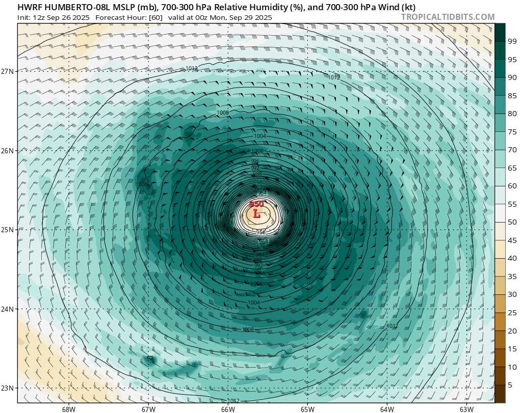
00z, September 2026, hurricane model blend, Humberto
--- Model peak intensity ---
HWRF = 944mb/124kt
HMON = 940mb/132kt
HAFS-A = 939mb/141kt
HAFS-B = 946mb/132kt
--- Hurricane model blend ---
Here's an overview of all the 00z hurricane models for Humberto with an averaged forecast of the 4 models. The models show Humberto becoming a hurricane around +18 to +27 hr, which might even be slower than what is happening in reality. Afterwards, all models are in agreement that Humberto will undergo consistent strengthening to a MH over the 24 hours afterwards. In fact, all models show the period of strengthening to continue until roughly the +84 / +90 hr, which allows Humberto to become a high-end cat 4 hurricane. Based on the spread within the hurricane models a peak intensity of 120 - 140 kt would be reasonable imo. Afterwards, Humberto slowly weakens but remains a MH until nearly the end of the run. Here, some models such as HMON and HAFS-B show post-tropical transition starting with the intensity rapidly dropping to the 70 - 85 kt mark, while HWRF and HAFS-A still show a more tropical Humberto with intensities in the 95 - 110 kt region. Until this 100+ hr mark where the post-tropical uncertainty starts, all hurricane models are in strong agreement in terms of track (standard deviations < 0.5 deg lat and lon) and intensity. If anything, there is a little more uncertainty in the short-term about how fast Humberto intensifies, but independent of this all models reach a category 4+ peak strength.
Blend
PEAK: 943 mb @ 84 hrs | 130 kt @ 84 hrs
ACE (0 - 126 hrs) = 21.4
Time (hr) / Pressure (mb) / Wind (kt) / Location (lat, lon [deg])
00 / 999 / 57 / 22.1N, 57.0W
06 / 995 / 59
12 / 997 / 59
18 / 991 / 58 / 22.7N, 58.1W
24 / 987 / 66 - C1
30 / 980 / 72
36 / 978 / 81 / 22.9N, 60.1W
42 / 970 / 92 - C2
48 / 966 / 99 - C3
54 / 961 / 100 / 23.5N, 63.1W
60 / 957 / 108
66 / 950 / 118 - C4
72 / 948 / 120 / 25.2N, 65.9W
78 / 946 / 124
84 / 943 / 130
90 / 945 / 119 / 27.6N, 68.5W
96 / 948 / 115
102 / 949 / 109
108 / 948 / 109 / 30.7N, 70.1W
114 / 947 / 108
120 / 947 / 103
126 / 950 / 92 / 35.7N, 68.9W
--- Previous blend analyses ---
None yet
Last edited by kevin on Fri Sep 26, 2025 3:25 am, edited 1 time in total.
1 likes
Re: NATL: HUMBERTO - Models
Well, I check the Humberto discussion thread right after posting this and it's now a hurricane. So indeed, Humberto is ahead of even the hurricane models in the short-term. This makes the high-end cat 4 (or higher) peak intensities shown by the hurricane models even more realistic.
3 likes

Re: NATL: HUMBERTO - Models
Unbelievable how the Euro gets this down to 914 mb.
2 likes
Igor 2010, Sandy 2012, Fay 2014, Gonzalo 2014, Joaquin 2015, Nicole 2016, Humberto 2019, Imelda 2025
I am only a tropical weather enthusiast. My predictions are not official and may or may not be backed by sound meteorological data. For official information, please refer to the NHC and NWS products.
I am only a tropical weather enthusiast. My predictions are not official and may or may not be backed by sound meteorological data. For official information, please refer to the NHC and NWS products.
-
StormWeather

- Category 1

- Posts: 477
- Joined: Wed Jun 05, 2024 2:34 pm
Re: NATL: HUMBERTO - Models
Kazmit wrote:Unbelievable how the Euro gets this down to 914 mb.
That has my attention now. That’s Cat 5 in pressure.
0 likes
Just an average cyclone tracker
The posts in this forum are NOT official forecasts and should not be used as such. They are just the opinion of the poster and may or may not be backed by sound meteorological data. They are NOT endorsed by any professional institution or storm2k.org. For official information, please refer to the NHC and NWS products
The posts in this forum are NOT official forecasts and should not be used as such. They are just the opinion of the poster and may or may not be backed by sound meteorological data. They are NOT endorsed by any professional institution or storm2k.org. For official information, please refer to the NHC and NWS products
Re: NATL: HUMBERTO - Models
Most 06z hurricane models still don't get this to hurricane intensity until the +12 to +21 hr range. And it's already a hurricane. And they then show ERI to a cat 4 at +48hr with still at least 30 hours of near-perfect conditions afterwards. High-end cat 4 to cat 5 is becoming realistic.
1 likes
Re: NATL: HUMBERTO - Models
12z guidance is the most aggressive so far with most models showing Humberto becoming a MH and about half of them showing a cat 4. A high-end cat 4 or low-end cat 5 is also possible.

3 likes
-
DorkyMcDorkface

- Category 5
- Posts: 1063
- Age: 28
- Joined: Mon Sep 30, 2019 1:32 pm
- Location: Mid-Atlantic
Re: NATL: HUMBERTO - Models
Could we be looking at the rare Atlantic a-word soon?
2 likes
Please note the thoughts expressed by this account are solely those of the user and are from a hobbyist perspective. For more comprehensive analysis, consult an actual professional meteorologist or meteorological agency.
Floyd 1999 | Isabel 2003 | Hanna 2008 | Irene 2011 | Sandy 2012 | Isaias 2020
-
cycloneye
- Admin
- Posts: 149822
- Age: 69
- Joined: Thu Oct 10, 2002 10:54 am
- Location: San Juan, Puerto Rico
Re: NATL: HUMBERTO - Models
HAFS-B up to cat 5 in 24 hours.

2 likes
Visit the Caribbean-Central America Weather Thread where you can find at first post web cams,radars
and observations from Caribbean basin members Click Here
and observations from Caribbean basin members Click Here

Re: NATL: HUMBERTO - Models
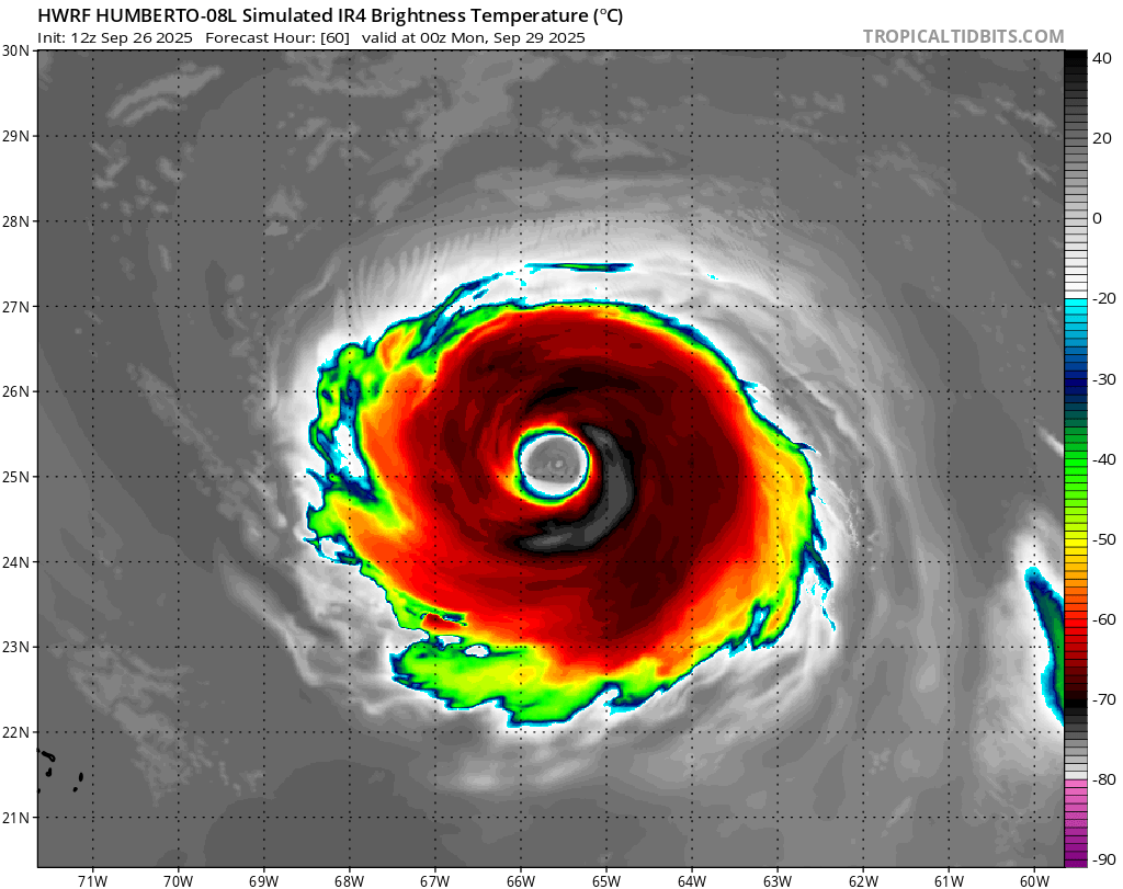
All hurricane models not named HWRF still show a brief Category 5 peak later today, including HAFS-A going up to 160 knots. HAFS-B shows a secondary Category 5 peak at 06z monday.
HWRF, 133kts at 09z Sunday:

HMON, 141kts at 03z Sunday:

HAFS-A, 159kts at 21z Saturday (it first reaches Cat 5 strength in 3 and a half hours so i think this one is a little overcooked):
HAFS-B, 142kts at 0z Sunday and again at 06z Monday (recon would catch the second one):
HWRF, 133kts at 09z Sunday:
HMON, 141kts at 03z Sunday:
HAFS-A, 159kts at 21z Saturday (it first reaches Cat 5 strength in 3 and a half hours so i think this one is a little overcooked):
 |  |
HAFS-B, 142kts at 0z Sunday and again at 06z Monday (recon would catch the second one):
 |  |
2 likes
-
MEANINGLESS_NUMBERS
- Category 2
- Posts: 503
- Joined: Mon Nov 02, 2020 1:43 pm
Re: NATL: HUMBERTO - Models
Very subtle shift of the ensembles closer to Bermuda. All suites have some members making landfall. Most still offshore to the north west but the probability of a landfall or eyewall is non-zero.
2 likes
Emily '87, Felix '95, Gert '99, Fabian '03, Humberto '19, Paulette '20, Teddy '20, Fiona '22, Lee '23, Ernesto '24, Humberto/Imelda '25
Re: NATL: HUMBERTO - Models
MEANINGLESS_NUMBERS wrote:Very subtle shift of the ensembles closer to Bermuda. All suites have some members making landfall. Most still offshore to the north west but the probability of a landfall or eyewall is non-zero.
I’ve been noticing that. It’s pretty tightly clustered so I still think it’s unlikely we get direct eyewall impacts but we could certainly see mid to high-end TS force winds. It will be a much larger storm by then.
0 likes
Igor 2010, Sandy 2012, Fay 2014, Gonzalo 2014, Joaquin 2015, Nicole 2016, Humberto 2019, Imelda 2025
I am only a tropical weather enthusiast. My predictions are not official and may or may not be backed by sound meteorological data. For official information, please refer to the NHC and NWS products.
I am only a tropical weather enthusiast. My predictions are not official and may or may not be backed by sound meteorological data. For official information, please refer to the NHC and NWS products.
Who is online
Users browsing this forum: No registered users and 4 guests