
ATL: Ex-INVEST 91L - Models
Moderator: S2k Moderators
Re: ATL: INVEST 91L - Models
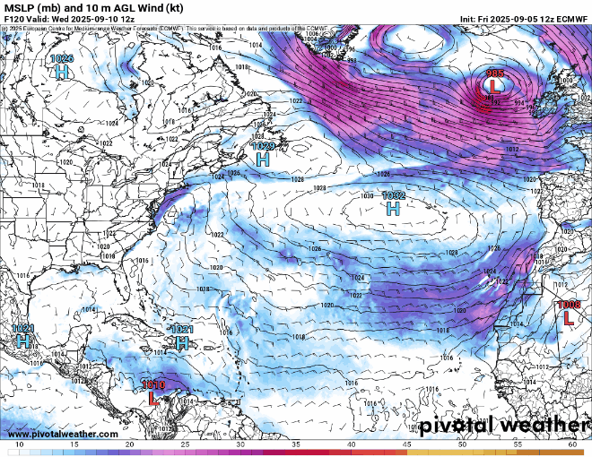
Weakest showing in about five day's worth of model runs. Massive model bust for the operational GFS if this ends up verifying.
2 likes
Re: ATL: INVEST 91L - Models
MLC remains somewhat there on the GFS, but there's nothing at the low levels into the Caribbean, and even that starts to fade in the east Caribbean. Have to use the 850 Relative vorticity to really track anything at all. Going to to keep watching it to see if it does something crazy later in the run. GFS is still flip flopping run/run on the ridging though. (Edit: it gets caught up in a CAG and front, it's dead dead)
Last edited by BobHarlem on Fri Sep 05, 2025 12:01 pm, edited 2 times in total.
0 likes
-
TampaWxLurker
- Tropical Storm

- Posts: 196
- Joined: Thu Aug 01, 2024 8:20 am
Re: ATL: INVEST 91L - Models
Wouldn't be surprised if the remnant energy eventually does something way down the road, but for the moment it appears that 91L lacks model support.
(Now watch the Euro come back and develop it)
(Now watch the Euro come back and develop it)
1 likes
-
Stratton23
- Category 5

- Posts: 3573
- Joined: Fri Jul 21, 2023 10:59 pm
- Location: Katy, Tx
Re: ATL: INVEST 91L - Models
Models are hinting at the CAG maybe trying to get somewhat more active in 10 days or so, still worth watching 91L as an open wave would track due west in the caribbean and probably end up somewhere in the western caribbean, just a slight possibility, but worth watching in case models try to do anything funny on these runs
0 likes

Re: ATL: INVEST 91L - Models
12Z JMA fwiw still has it in the MDR at 72 (1008 mb TC). So far, it is the only major 12Z op model still with it with only the Euro to go. And the JMA is highly unreliable.
0 likes
Personal Forecast Disclaimer:
The posts in this forum are NOT official forecasts and should not be used as such. They are just the opinion of the poster and may or may not be backed by sound meteorological data. They are NOT endorsed by any professional institution or storm2k.org. For official information, please refer to the NHC and NWS products.
The posts in this forum are NOT official forecasts and should not be used as such. They are just the opinion of the poster and may or may not be backed by sound meteorological data. They are NOT endorsed by any professional institution or storm2k.org. For official information, please refer to the NHC and NWS products.
-
Stratton23
- Category 5
- Posts: 3573
- Joined: Fri Jul 21, 2023 10:59 pm
- Location: Katy, Tx
Re: ATL: INVEST 91L - Models
12z GFS tracks 91L as a weak wave that interacts and gets absorbed into the CAG, we see a area of low pressure form in the yucatan channel as a combination of the CAG but also 91L’s remnants, still think this is worth watching despite all models really dropping it
0 likes


Re: ATL: INVEST 91L - Models
BobHarlem wrote:No development on the 12z Euro.
Thanks, Bob. Good news for the islands. Boring for tracking is obviously much preferred over potential destruction/casualties!
So, the highly unreliable JMA, especially when it’s on its own, is the line holdout of this cycle for a TC in the tropics from this.
0 likes
Personal Forecast Disclaimer:
The posts in this forum are NOT official forecasts and should not be used as such. They are just the opinion of the poster and may or may not be backed by sound meteorological data. They are NOT endorsed by any professional institution or storm2k.org. For official information, please refer to the NHC and NWS products.
The posts in this forum are NOT official forecasts and should not be used as such. They are just the opinion of the poster and may or may not be backed by sound meteorological data. They are NOT endorsed by any professional institution or storm2k.org. For official information, please refer to the NHC and NWS products.
-
ConvergenceZone
.gif)
- Category 5
- Posts: 5241
- Joined: Fri Jul 29, 2005 1:40 am
- Location: Northern California
Re: ATL: INVEST 91L - Models
LarryWx wrote:BobHarlem wrote:No development on the 12z Euro.
Thanks, Bob. Good news for the islands. Boring for tracking is obviously much preferred over potential destruction/casualties!
So, the highly unreliable JMA, especially when it’s on its own, is the line holdout of this cycle for a TC in the tropics from this.
I agree with ya. As much as I like tracking things. I hate the destruction and potential loss of life storms brings, especially to animals who can't get out of the way
2 likes
-
DunedinDave
- Category 1

- Posts: 269
- Joined: Fri Aug 25, 2023 10:31 am
Re: ATL: INVEST 91L - Models
Like I said earlier today, it just seems to be a pattern right with systems coming across. Early promise and then *poof*.
It’s amazing looking at the long term models that we may get into late Sept with hardly anything.
Whats going on this year?
It’s amazing looking at the long term models that we may get into late Sept with hardly anything.
Whats going on this year?
0 likes
-
redingtonbeach
- Tropical Depression

- Posts: 65
- Joined: Mon Sep 04, 2017 12:05 am
Re: ATL: INVEST 91L - Models
DunedinDave wrote:Like I said earlier today, it just seems to be a pattern right with systems coming across. Early promise and then *poof*.
It’s amazing looking at the long term models that we may get into late Sept with hardly anything.
Whats going on this year?
God’s blessing.
1 likes

Re: ATL: INVEST 91L - Models
FWIW, 12z HWRF still has a TS approaching the Leeward Islands. Peaks at 994 mb, then weakens slightly in later frames. So JMA is technically not the only model that still shows development, I guess?
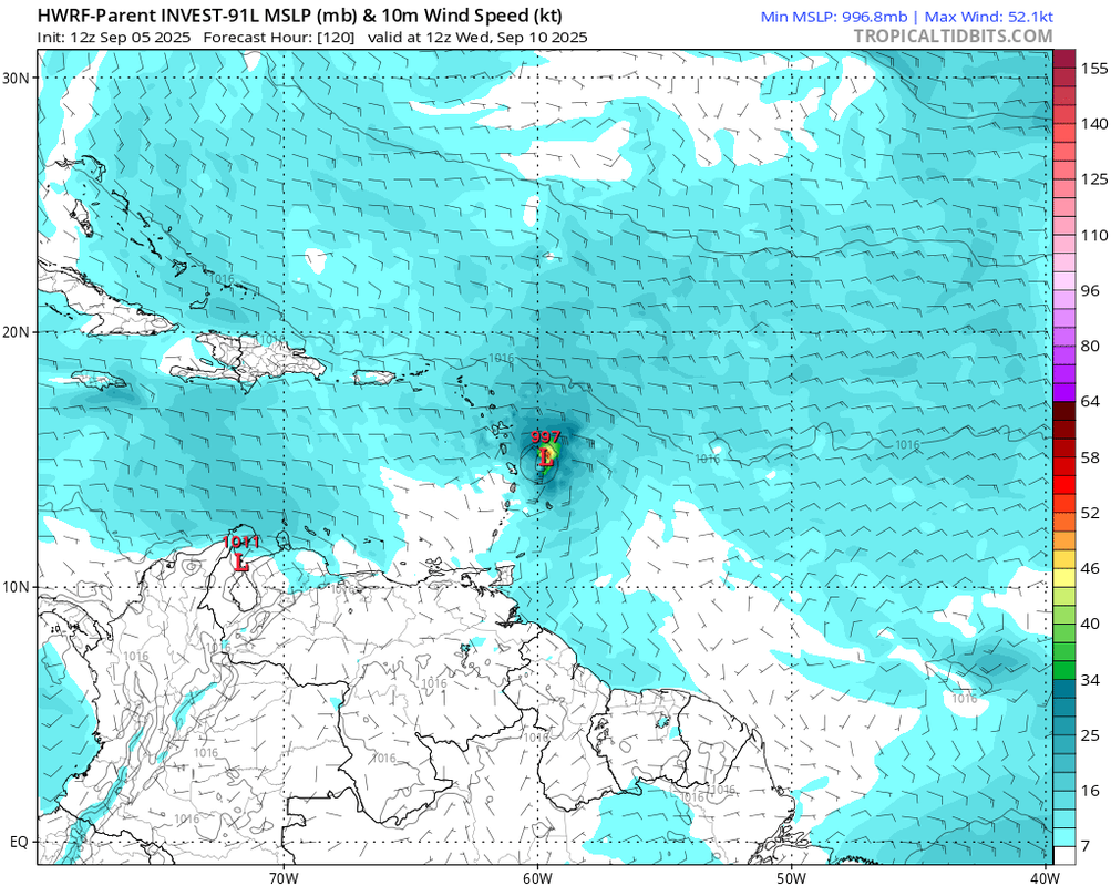
The other 3 hurricane models don't show a TC, although HAFS-A and HAFS-B show a ball of vorticity that tries to get going west of 45-50W. The wave is convectively active even when crossing the Lesser Antilles, but with no organization.
The other 3 hurricane models don't show a TC, although HAFS-A and HAFS-B show a ball of vorticity that tries to get going west of 45-50W. The wave is convectively active even when crossing the Lesser Antilles, but with no organization.
1 likes
TC naming lists: retirements and intensity
Most aggressive Advisory #1's in North Atlantic (cr. kevin for starting the list)
Most aggressive Advisory #1's in North Atlantic (cr. kevin for starting the list)
Re: ATL: INVEST 91L - Models
Teban54 wrote:FWIW, 12z HWRF still has a TS approaching the Leeward Islands. Peaks at 994 mb, then weakens slightly in later frames. So JMA is technically not the only model that still shows development, I guess?
https://i.postimg.cc/Bb2C5JT2/image.png
The other 3 hurricane models don't show a TC, although HAFS-A and HAFS-B show a ball of vorticity that tries to get going west of 45-50W. The wave is convectively active even when crossing the Lesser Antilles, but with no organization.
For record-keeping purposes now that the rest of the run has been released, the 12Z JMA is a bit slower than the prior two. But it still has a similar idea of an early recurve with a H moving N along 60W 144-192.
0 likes
Personal Forecast Disclaimer:
The posts in this forum are NOT official forecasts and should not be used as such. They are just the opinion of the poster and may or may not be backed by sound meteorological data. They are NOT endorsed by any professional institution or storm2k.org. For official information, please refer to the NHC and NWS products.
The posts in this forum are NOT official forecasts and should not be used as such. They are just the opinion of the poster and may or may not be backed by sound meteorological data. They are NOT endorsed by any professional institution or storm2k.org. For official information, please refer to the NHC and NWS products.
-
StormWeather

- Category 1
- Posts: 477
- Joined: Wed Jun 05, 2024 2:34 pm
Re: ATL: INVEST 91L - Models
Teban54 wrote:FWIW, 12z HWRF still has a TS approaching the Leeward Islands. Peaks at 994 mb, then weakens slightly in later frames. So JMA is technically not the only model that still shows development, I guess?
https://i.postimg.cc/Bb2C5JT2/image.png
The other 3 hurricane models don't show a TC, although HAFS-A and HAFS-B show a ball of vorticity that tries to get going west of 45-50W. The wave is convectively active even when crossing the Lesser Antilles, but with no organization.
So maybe we should pump the brakes and just wait and see…
0 likes
Just an average cyclone tracker
The posts in this forum are NOT official forecasts and should not be used as such. They are just the opinion of the poster and may or may not be backed by sound meteorological data. They are NOT endorsed by any professional institution or storm2k.org. For official information, please refer to the NHC and NWS products
The posts in this forum are NOT official forecasts and should not be used as such. They are just the opinion of the poster and may or may not be backed by sound meteorological data. They are NOT endorsed by any professional institution or storm2k.org. For official information, please refer to the NHC and NWS products
-
MEANINGLESS_NUMBERS
- Category 2

- Posts: 503
- Joined: Mon Nov 02, 2020 1:43 pm
Re: ATL: INVEST 91L - Models
Anyone knowledgeable able to explain the sudden loss of model support? What are they seeing today that they weren't seeing 36 hours ago?
2 likes
Emily '87, Felix '95, Gert '99, Fabian '03, Humberto '19, Paulette '20, Teddy '20, Fiona '22, Lee '23, Ernesto '24, Humberto/Imelda '25
Re: ATL: INVEST 91L - Models
Happy Hour Icon had a happy result for the Lesser Antilles: no TC (similar to 12Z).
0 likes
Personal Forecast Disclaimer:
The posts in this forum are NOT official forecasts and should not be used as such. They are just the opinion of the poster and may or may not be backed by sound meteorological data. They are NOT endorsed by any professional institution or storm2k.org. For official information, please refer to the NHC and NWS products.
The posts in this forum are NOT official forecasts and should not be used as such. They are just the opinion of the poster and may or may not be backed by sound meteorological data. They are NOT endorsed by any professional institution or storm2k.org. For official information, please refer to the NHC and NWS products.
Re: ATL: INVEST 91L - Models
LarryWx wrote:Happy Hour Icon had a happy result for the Lesser Antilles: no TC (similar to 12Z).
GFS with a similar
1 likes
Who is online
Users browsing this forum: No registered users and 64 guests