ATL: Ex INVEST 99L - Discussion
Moderator: S2k Moderators
Re: ATL: INVEST 99L - Discussion (40/40)
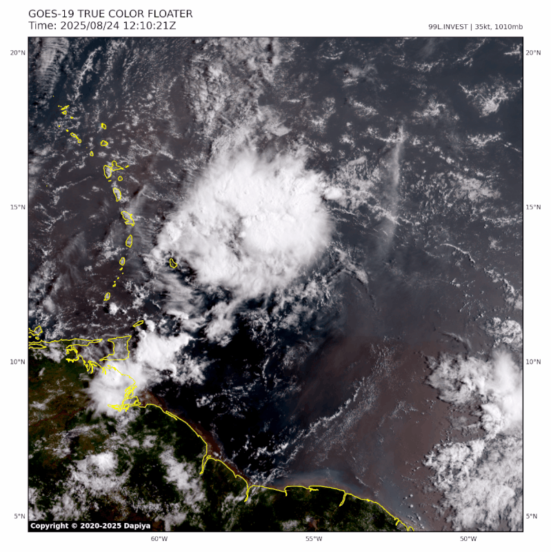
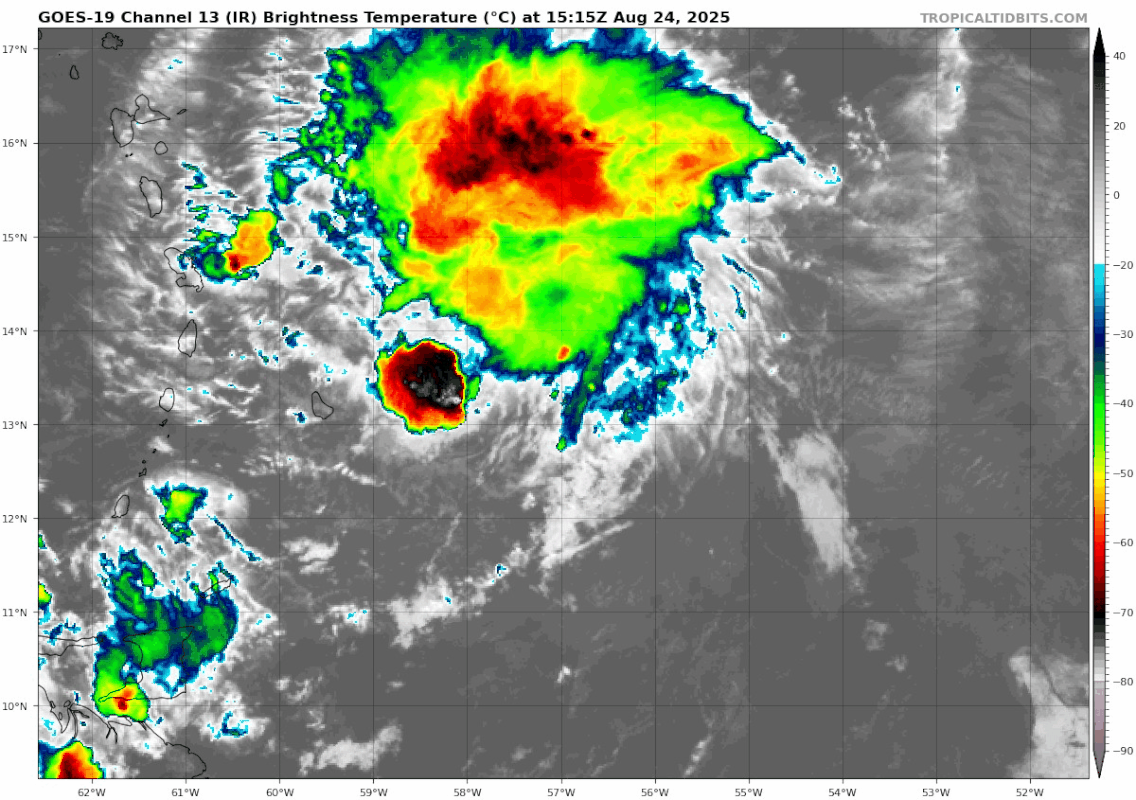
It seems it’s treking north of guidance at present time
1 likes
-
Sciencerocks
- Category 5

- Posts: 10181
- Age: 40
- Joined: Thu Jul 06, 2017 1:51 am

-
Cachondo23
- Tropical Storm

- Posts: 131
- Joined: Wed May 25, 2022 5:56 am
Re: ATL: INVEST 99L - Discussion (40/40)
LAF92 wrote:It seems it’s treking north of guidance at present time
Yeah, looks like very heavy rain in Martinique right now. Barbados will get some soon per radar. Dominica and Guadaluope could follow later.
0 likes
Re: ATL: INVEST 99L - Discussion (40/40)
Shear is a bit lower now compared to most of its lifetime, giving 99L a short reprieve before it enters the Caribbean graveyard... kind of like some time to power up before meeting the next boss.

I do see a bit more rotation near the end of the loop... maybe this persistent little wave will finally have a chance to earn itself a name, provided it organizes itself in the short window it has. It has been done before, and you can never write off a 99L. Recon should be in shortly.
I do see a bit more rotation near the end of the loop... maybe this persistent little wave will finally have a chance to earn itself a name, provided it organizes itself in the short window it has. It has been done before, and you can never write off a 99L. Recon should be in shortly.
1 likes
-
TomballEd
- Category 5
- Posts: 1263
- Age: 62
- Joined: Wed Aug 16, 2023 4:52 pm
- Location: Spring/Klein area, not Tomball
Re: ATL: INVEST 99L - Discussion (40/40)
zhukm29 wrote:Shear is a bit lower now compared to most of its lifetime, giving 99L a short reprieve before it enters the Caribbean graveyard... kind of like some time to power up before meeting the next boss.
https://i.ibb.co/67t0rFXM/wg8shr.gif
I do see a bit more rotation near the end of the loop... maybe this persistent little wave will finally have a chance to earn itself a name, provided it organizes itself in the short window it has. It has been done before, and you can never write off a 99L. Recon should be in shortly.
https://i.postimg.cc/GhxLm2Jc/c9253aee-43b1-4422-bb95-a7246bd3f85c.gif
Recon seems to suggest a wave axis with a point on that axis being near Grande-Terre.
0 likes
-
cycloneye

- Admin

- Posts: 149275
- Age: 69
- Joined: Thu Oct 10, 2002 10:54 am
- Location: San Juan, Puerto Rico
Re: ATL: INVEST 99L - Discussion (40/40)
Tropical Weather Outlook
NWS National Hurricane Center Miami FL
200 PM EDT Sun Aug 24 2025
East of the Windward Islands (AL99):
A tropical wave located just east of the Windward Islands continues
to produce shower and thunderstorm activity. While satellite data
indicates that the wave does not appear to have a surface
circulation, an Air Force Reserve reconnaissance aircraft is
currently investigating the area. This system could still become a
tropical depression during the next day or two while it moves
quickly westward at about 20 to 25 mph, passing through the Windward
and Leeward Islands later today and early Monday. Regardless of
development, heavy rainfall and gusty winds to tropical storm force
are likely across portions of the Windward and Leeward Islands
today and Monday. The system is expected to reach the central
Caribbean Sea on Tuesday, where conditions are forecast to become
less favorable for additional development.
* Formation chance through 48 hours...medium...40 percent.
* Formation chance through 7 days...medium...40 percent.
0 likes
Visit the Caribbean-Central America Weather Thread where you can find at first post web cams,radars
and observations from Caribbean basin members Click Here
and observations from Caribbean basin members Click Here
-
Sciencerocks
- Category 5
- Posts: 10181
- Age: 40
- Joined: Thu Jul 06, 2017 1:51 am
Re: ATL: INVEST 99L - Discussion (40/40)
For the first time in 5 days it doesn't have an LLC on satellite or even with recon. lol You can't make this poop up. I bet 20 bucks if it had gone into it 3 days ago they would have named it.
3 likes
-
Stratton23
- Category 5
- Posts: 3523
- Joined: Fri Jul 21, 2023 10:59 pm
- Location: Katy, Tx
-
StormWeather

- Category 1

- Posts: 475
- Joined: Wed Jun 05, 2024 2:34 pm
Re: ATL: INVEST 99L - Discussion (40/40)
Stratton23 wrote:And thats about all she wrote on this system, next
I’m not ready to call it quits yet. Recon just did a loop within a loop and I’m thinking that I am seeing a NW to SW turning in that area could be happening. Could just be a wave axis, and that is my best bet for now.
0 likes
Just an average cyclone tracker
The posts in this forum are NOT official forecasts and should not be used as such. They are just the opinion of the poster and may or may not be backed by sound meteorological data. They are NOT endorsed by any professional institution or storm2k.org. For official information, please refer to the NHC and NWS products
The posts in this forum are NOT official forecasts and should not be used as such. They are just the opinion of the poster and may or may not be backed by sound meteorological data. They are NOT endorsed by any professional institution or storm2k.org. For official information, please refer to the NHC and NWS products
-
Stratton23
- Category 5
- Posts: 3523
- Joined: Fri Jul 21, 2023 10:59 pm
- Location: Katy, Tx
Re: ATL: INVEST 99L - Discussion (40/40)
Stormweather its possible, but since its likely just a wave axis, its going to get shredded apart in the caribbean now , i guess the one to watch is if this wave splits and a piece of this somehow ends up in the gulf, although that seems unlikely given its doesnt have a closed low
1 likes
-
TomballEd
- Category 5
- Posts: 1263
- Age: 62
- Joined: Wed Aug 16, 2023 4:52 pm
- Location: Spring/Klein area, not Tomball
Re: ATL: INVEST 99L - Discussion (40/40)
Posted in recon thread as well. It looks like a sharp wave. I do hope the plane flies a little farther S just to be sure.
I think its best chance of development is in the East Pac, but there are GFS ensemble outliers with impressive Gulf storms (see models thread) Or too soon to say 'next'.

I think its best chance of development is in the East Pac, but there are GFS ensemble outliers with impressive Gulf storms (see models thread) Or too soon to say 'next'.
1 likes
-
floridasun
- Tropical Storm
- Posts: 245
- Joined: Tue Sep 14, 2021 3:59 pm
Re: ATL: INVEST 99L - Discussion (40/40)
we likely won't see any system next week so doing peak part season this going into area that tropical wave gets destroy high too strong pull it fast west enjoy long weekend next weekend don't anything forming unless surprise
0 likes
Re: ATL: INVEST 99L - Discussion (40/40)
Plane is doing a SW pass, seems like this is where it could be consolidating. 99L being less organized is a good thing though as it reduces the likelihood it could get pulled up into the Gulf.

0 likes

Re: ATL: INVEST 99L - Discussion (40/40)
Recon hasn't found any yellow barbed winds over 45 mph so NHC skipped the issues with posting late warnings.
Its a wave with lowest pressures near 1012 mb. Low pressure extends quite far north and they haven't flown the southern part of the wave yet.
Its a wave with lowest pressures near 1012 mb. Low pressure extends quite far north and they haven't flown the southern part of the wave yet.
0 likes
-
Stratton23
- Category 5
- Posts: 3523
- Joined: Fri Jul 21, 2023 10:59 pm
- Location: Katy, Tx
Re: ATL: INVEST 99L - Discussion (40/40)
No closed low yet, but its becoming evident that it is most certainly trying to close off a low, we will see, the SW side is definitely becoming a little more “ consolidated” if you ask me
1 likes


Re: ATL: INVEST 99L - Discussion (40/40)
LAF92 wrote:It seems it’s treking north of guidance at present time
Agreed; I see a somewhat more pronounced albeit weak circulation around 15.5 N, with a possible much smaller potential area of turning further south at 13.5 N. The southernmost point happens to be where the most intense convection us occurring
0 likes
Andy D
(For official information, please refer to the NHC and NWS products.)
(For official information, please refer to the NHC and NWS products.)
-
cycloneye
- Admin
- Posts: 149275
- Age: 69
- Joined: Thu Oct 10, 2002 10:54 am
- Location: San Juan, Puerto Rico
Re: ATL: INVEST 99L - Discussion (30/30)
East of the Windward Islands (AL99):
Data from the Air Force reconnaissance aircraft indicate that the
system located near the Windward Islands does not have a closed
low-level circulation. However, the system is still producing a
large area of showers and thunderstorms and winds to near gale
force, and these conditions are expected to affect the Windward and
Leeward Islands tonight and Monday. The system is expected to reach
the central Caribbean Sea on Tuesday, where conditions are forecast
to become less favorable for additional development.
* Formation chance through 48 hours...low...30 percent.
* Formation chance through 7 days...low...30 percent.
0 likes
Visit the Caribbean-Central America Weather Thread where you can find at first post web cams,radars
and observations from Caribbean basin members Click Here
and observations from Caribbean basin members Click Here
-
TomballEd
- Category 5
- Posts: 1263
- Age: 62
- Joined: Wed Aug 16, 2023 4:52 pm
- Location: Spring/Klein area, not Tomball
Re: ATL: INVEST 99L - Discussion (30/30)
There is recon data now for the 0Z models to run with, the first pass through the wave axis came right around 18Z. Maybe the models will find something. But so far, support has dropped on the models and lower level *divergence* is ahead of 99L, without a closed center it will struggle to even maintain convection.

0 likes
-
cycloneye
- Admin
- Posts: 149275
- Age: 69
- Joined: Thu Oct 10, 2002 10:54 am
- Location: San Juan, Puerto Rico
Re: ATL: INVEST 99L - Discussion (30/30)
Tropical Weather Outlook
NWS National Hurricane Center Miami FL
800 PM EDT Sun Aug 24 2025
For the North Atlantic...Caribbean Sea and the Gulf of America:
Active Systems:
The National Hurricane Center is issuing advisories on Tropical
Storm Fernand, located over the central subtropical Atlantic.
1. East the Windward Islands (AL99):
The tropical wave just east of the Windward Islands is producing a
large area of showers and thunderstorms with winds to near gale
force. These conditions are expected to affect the Windward and
Leeward Islands tonight and Monday. Earlier reconnaissance aircraft
data indicated that the system did not have a closed low-level
circulation. Another Air Force reconnaissance aircraft is scheduled
to investigate the system overnight, if necessary. The disturbance
is expected to reach the central Caribbean Sea on Tuesday, where
conditions are forecast to become less favorable for additional
development.
* Formation chance through 48 hours...low...30 percent.
* Formation chance through 7 days...low...30 percent.
Forecaster Kelly
0 likes
Visit the Caribbean-Central America Weather Thread where you can find at first post web cams,radars
and observations from Caribbean basin members Click Here
and observations from Caribbean basin members Click Here
Who is online
Users browsing this forum: No registered users and 49 guests