NATL: MELISSA - Models

Moderator: S2k Moderators

Message
Author
AutoPenalti
Category 5
Category 5
Posts: 4091
Age: 29
Joined: Mon Aug 17, 2015 4:16 pm
Location: Ft. Lauderdale, Florida

Re: NATL: MELISSA - Models

#221 Postby AutoPenalti » Wed Oct 22, 2025 9:58 am

ronjon wrote:


Blp, are those all possible ensemble runs for one time period or do they represent HCAA tracks from different periods. Or maybe a better question is what models are part of the HCAA consensus?

It's tracks from older time periods to the most current.
0 likes   
The posts in this forum are NOT official forecasts and should not be used as such. They are just the opinion of the poster and may or may not be backed by sound meteorological data. They are NOT endorsed by any professional institution or STORM2K. For official information, please refer to products from the NHC and NWS.


Model Runs Cheat Sheet:
GFS (5:30 AM/PM, 11:30 AM/PM)
HWRF, GFDL, UKMET, NAVGEM (6:30-8:00 AM/PM, 12:30-2:00 AM/PM)
ECMWF (1:45 AM/PM)

TCVN
is a weighted averaged

caneseddy
Category 5
Category 5
Posts: 1193
Joined: Fri Sep 03, 2004 9:31 pm
Location: Plantation, FL

Re: NATL: MELISSA - Models

#222 Postby caneseddy » Wed Oct 22, 2025 10:05 am

AutoPenalti wrote:
ronjon wrote:


Blp, are those all possible ensemble runs for one time period or do they represent HCAA tracks from different periods. Or maybe a better question is what models are part of the HCAA consensus?

It's tracks from older time periods to the most current.


I'm assuming the red line would be the most current based on trends?
0 likes   

User avatar
SFLcane
S2K Supporter
S2K Supporter
Posts: 10281
Age: 48
Joined: Sat Jun 05, 2010 1:44 pm
Location: Lake Worth Florida

Re: NATL: MELISSA - Models

#223 Postby SFLcane » Wed Oct 22, 2025 10:09 am


Should head NE-ENE from that point across Cuba. Nothing is ever certain but I think the door is pretty much closed for anything trying to sneak through yucatan channel which could potentially threaten SFL.
1 likes   

User avatar
SFLcane
S2K Supporter
S2K Supporter
Posts: 10281
Age: 48
Joined: Sat Jun 05, 2010 1:44 pm
Location: Lake Worth Florida

Re: NATL: MELISSA - Models

#224 Postby SFLcane » Wed Oct 22, 2025 10:10 am

caneseddy wrote:
AutoPenalti wrote:
ronjon wrote:
Blp, are those all possible ensemble runs for one time period or do they represent HCAA tracks from different periods. Or maybe a better question is what models are part of the HCAA consensus?

It's tracks from older time periods to the most current.


I'm assuming the red line would be the most current based on trends?


That is correct.
1 likes   

AutoPenalti
Category 5
Category 5
Posts: 4091
Age: 29
Joined: Mon Aug 17, 2015 4:16 pm
Location: Ft. Lauderdale, Florida

Re: NATL: MELISSA - Models

#225 Postby AutoPenalti » Wed Oct 22, 2025 10:12 am

caneseddy wrote:
AutoPenalti wrote:
ronjon wrote:
Blp, are those all possible ensemble runs for one time period or do they represent HCAA tracks from different periods. Or maybe a better question is what models are part of the HCAA consensus?

It's tracks from older time periods to the most current.


I'm assuming the red line would be the most current based on trends?

Correct. It filters through bias from in-house and operational models and uses the HWRF as the driving dynamical model TC Intensity Guidance
1 likes   
The posts in this forum are NOT official forecasts and should not be used as such. They are just the opinion of the poster and may or may not be backed by sound meteorological data. They are NOT endorsed by any professional institution or STORM2K. For official information, please refer to products from the NHC and NWS.


Model Runs Cheat Sheet:
GFS (5:30 AM/PM, 11:30 AM/PM)
HWRF, GFDL, UKMET, NAVGEM (6:30-8:00 AM/PM, 12:30-2:00 AM/PM)
ECMWF (1:45 AM/PM)

TCVN
is a weighted averaged

BobHarlem
Category 5
Category 5
Posts: 2566
Joined: Thu Oct 20, 2005 6:11 pm

Re: NATL: MELISSA - Models

#226 Postby BobHarlem » Wed Oct 22, 2025 10:17 am

12z icon again wrecks Jamaica (Right front quad along the southern part of the island, including Kingston)

Image
0 likes   

xironman
S2K Supporter
S2K Supporter
Posts: 2535
Joined: Sun Jun 10, 2007 4:53 pm
Location: NoVA

Re: NATL: MELISSA - Models

#227 Postby xironman » Wed Oct 22, 2025 10:19 am

SFLcane wrote:


Should head NE-ENE from that point across Cuba. Nothing is ever certain but I think the door is pretty much closed for anything trying to sneak through yucatan channel which could potentially threaten SFL.


The 500mb pattern at that time is not set in stone.
0 likes   

AutoPenalti
Category 5
Category 5
Posts: 4091
Age: 29
Joined: Mon Aug 17, 2015 4:16 pm
Location: Ft. Lauderdale, Florida

Re: NATL: MELISSA - Models

#228 Postby AutoPenalti » Wed Oct 22, 2025 10:24 am

SFLcane wrote:


Should head NE-ENE from that point across Cuba. Nothing is ever certain but I think the door is pretty much closed for anything trying to sneak through yucatan channel which could potentially threaten SFL.

Should but the synoptic set up is not set in stone, if anything recent Euro trends indicate the trough retrograding further north. The longer this stays south and west, the more time it will take for models to get a pattern set up.
Last edited by AutoPenalti on Wed Oct 22, 2025 10:25 am, edited 1 time in total.
0 likes   
The posts in this forum are NOT official forecasts and should not be used as such. They are just the opinion of the poster and may or may not be backed by sound meteorological data. They are NOT endorsed by any professional institution or STORM2K. For official information, please refer to products from the NHC and NWS.


Model Runs Cheat Sheet:
GFS (5:30 AM/PM, 11:30 AM/PM)
HWRF, GFDL, UKMET, NAVGEM (6:30-8:00 AM/PM, 12:30-2:00 AM/PM)
ECMWF (1:45 AM/PM)

TCVN
is a weighted averaged

User avatar
SFLcane
S2K Supporter
S2K Supporter
Posts: 10281
Age: 48
Joined: Sat Jun 05, 2010 1:44 pm
Location: Lake Worth Florida

Re: NATL: MELISSA - Models

#229 Postby SFLcane » Wed Oct 22, 2025 10:25 am

xironman wrote:
SFLcane wrote:


Should head NE-ENE from that point across Cuba. Nothing is ever certain but I think the door is pretty much closed for anything trying to sneak through yucatan channel which could potentially threaten SFL.


The 500mb pattern at that time is not set in stone.


The 500mb pattern is pretty much in our favor across the peninsula hence not 1 ensemble brings over the state. Never like to make bold statements with a storm to our south in oct but unless something changes i feel pretty good saying we should be good here.

Image

Image
0 likes   

Fancy1002
Category 1
Category 1
Posts: 322
Joined: Sun Dec 25, 2022 3:47 pm

Re: NATL: MELISSA - Models

#230 Postby Fancy1002 » Wed Oct 22, 2025 10:37 am

SFLcane wrote:
xironman wrote:
SFLcane wrote:
Should head NE-ENE from that point across Cuba. Nothing is ever certain but I think the door is pretty much closed for anything trying to sneak through yucatan channel which could potentially threaten SFL.


The 500mb pattern at that time is not set in stone.


The 500mb pattern is pretty much in our favor across the peninsula hence not 1 ensemble brings over the state. Never like to make bold statements with a storm to our south in oct but unless something changes i feel pretty good saying we should be good here.

https://i.postimg.cc/6Qk1x3Kj/vvvv.png

https://i.postimg.cc/52Rfvw5F/vvv.png

I see a few of those ensemble heading up to the northeast.
0 likes   

User avatar
SFLcane
S2K Supporter
S2K Supporter
Posts: 10281
Age: 48
Joined: Sat Jun 05, 2010 1:44 pm
Location: Lake Worth Florida

Re: NATL: MELISSA - Models

#231 Postby SFLcane » Wed Oct 22, 2025 10:41 am

Fancy1002 wrote:
SFLcane wrote:
xironman wrote:
The 500mb pattern at that time is not set in stone.


The 500mb pattern is pretty much in our favor across the peninsula hence not 1 ensemble brings over the state. Never like to make bold statements with a storm to our south in oct but unless something changes i feel pretty good saying we should be good here.

https://i.postimg.cc/6Qk1x3Kj/vvvv.png

https://i.postimg.cc/52Rfvw5F/vvv.png

I see a few of those ensemble heading up to the northeast.


A handful not very likely at all.
0 likes   

User avatar
boca
Category 5
Category 5
Posts: 6400
Age: 61
Joined: Mon Dec 15, 2003 8:49 am
Location: Boca Raton,FL

Re: NATL: MELISSA - Models

#232 Postby boca » Wed Oct 22, 2025 10:52 am

I wouldn’t rule out Florida yet the further west Melissa travels the more in play Florida is before the NE turn and the set up is changing every day it seems like.
0 likes   

CrazyC83
Professional-Met
Professional-Met
Posts: 34306
Joined: Tue Mar 07, 2006 11:57 pm
Location: Deep South, for the first time!

Re: NATL: MELISSA - Models

#233 Postby CrazyC83 » Wed Oct 22, 2025 10:58 am


Never say never. Wilma nearly got to such.
0 likes   

BobHarlem
Category 5
Category 5
Posts: 2566
Joined: Thu Oct 20, 2005 6:11 pm

Re: NATL: MELISSA - Models

#234 Postby BobHarlem » Wed Oct 22, 2025 10:58 am

boca wrote:I wouldn’t rule out Florida yet the further west Melissa travels the more in play Florida is before the NE turn and the set up is changing every day it seems like.

Extremely unlikely looking at the pwat and continental US frontal setup It would have to get to the northern tip of the Yucatan to do that. It's more likely to plough into Central America than get to florida. Cayman islands, Cuba/Bahamas perhaps.
1 likes   

User avatar
Travorum
Category 2
Category 2
Posts: 623
Joined: Tue Sep 05, 2023 9:36 am
Location: Dunedin, FL

Re: NATL: MELISSA - Models

#235 Postby Travorum » Wed Oct 22, 2025 11:06 am

The 06z experimental HAFS-B run was... something to say the least. Basically an Atlantic Patricia:

ImageImage
4 likes   

User avatar
SFLcane
S2K Supporter
S2K Supporter
Posts: 10281
Age: 48
Joined: Sat Jun 05, 2010 1:44 pm
Location: Lake Worth Florida

Re: NATL: MELISSA - Models

#236 Postby SFLcane » Wed Oct 22, 2025 11:11 am

BobHarlem wrote:
boca wrote:I wouldn’t rule out Florida yet the further west Melissa travels the more in play Florida is before the NE turn and the set up is changing every day it seems like.

Extremely unlikely looking at the pwat and continental US frontal setup It would have to get to the northern tip of the Yucatan to do that. It's more likely to plough into Central America than get to florida. Cayman islands, Cuba/Bahamas perhaps.


Shear is howling across the gulf and florida with the jetstream now drapped accross the area.

Image

Image
0 likes   

User avatar
DESTRUCTION5
Category 5
Category 5
Posts: 4430
Age: 44
Joined: Wed Sep 03, 2003 11:25 am
Location: Stuart, FL

Re: NATL: MELISSA - Models

#237 Postby DESTRUCTION5 » Wed Oct 22, 2025 11:12 am

12z GFS continues its out to lunch solution with a NE turn basically starting now.
0 likes   
GATOR NATION IS E V E R Y W H E R E !

User avatar
Travorum
Category 2
Category 2
Posts: 623
Joined: Tue Sep 05, 2023 9:36 am
Location: Dunedin, FL

NATL: MELISSA - Tropical Storm - Discussion

#238 Postby Travorum » Wed Oct 22, 2025 11:15 am

The NOAA G-IV is doing a synoptic training mission around Melissa right now, hopefully some dropsonde data can be collected to feed into the models.
2 likes   

Fancy1002
Category 1
Category 1
Posts: 322
Joined: Sun Dec 25, 2022 3:47 pm

Re: NATL: MELISSA - Models

#239 Postby Fancy1002 » Wed Oct 22, 2025 11:19 am

Gotta give it to both the GFS and the UKMET for their consistency, even if they end up being dead wrong.
4 likes   

LarryWx
S2K Supporter
S2K Supporter
Posts: 6854
Joined: Sun Sep 07, 2003 2:04 pm
Location: GA

Re: NATL: MELISSA - Models

#240 Postby LarryWx » Wed Oct 22, 2025 11:36 am

Fancy1002 wrote:Gotta give it to both the GFS and the UKMET for their consistency, even if they end up being dead wrong.


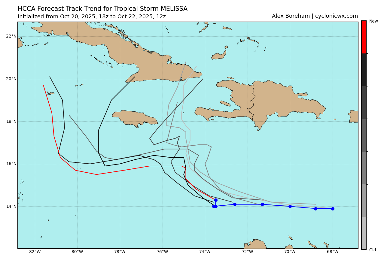
Speaking of the UKMET, the 12Z has a similar path with it still weak although it has been ending up slightly further N at the ends of the last few runs. Earlier runs were going into Nicaragua and falling apart. Then they were going toward the Nic/Hond border and/or skimming the N coast of Hond. This latest one moves WNW toward the end of the run into the open southern Gulf of Honduras and stalls without falling apart and appears to be starting to strengthen:

TROPICAL STORM MELISSA ANALYSED POSITION : 14.2N 73.9W

ATCF IDENTIFIER : AL132025

LEAD CENTRAL MAXIMUM WIND
VERIFYING TIME TIME POSITION PRESSURE (MB) SPEED (KNOTS)
-------------- ---- -------- ------------- -------------
1200UTC 22.10.2025 0 14.2N 73.9W 1004 35
0000UTC 23.10.2025 12 15.5N 74.8W 1003 39
1200UTC 23.10.2025 24 15.5N 75.8W 1004 36
0000UTC 24.10.2025 36 15.7N 76.2W 1004 28
1200UTC 24.10.2025 48 15.6N 76.2W 1004 26
0000UTC 25.10.2025 60 15.6N 76.5W 1004 27
1200UTC 25.10.2025 72 15.8N 77.0W 1005 28
0000UTC 26.10.2025 84 15.6N 78.3W 1004 27
1200UTC 26.10.2025 96 15.7N 79.7W 1004 25
0000UTC 27.10.2025 108 15.6N 81.4W 1003 22
1200UTC 27.10.2025 120 15.2N 82.6W 1003 24
0000UTC 28.10.2025 132 15.5N 83.7W 1004 20
1200UTC 28.10.2025 144 16.3N 84.8W 1005 23
0000UTC 29.10.2025 156 16.4N 86.3W 1005 27
1200UTC 29.10.2025 168 16.6N 86.5W 1004 34
Last edited by LarryWx on Wed Oct 22, 2025 11:40 am, edited 4 times in total.
1 likes   
Personal Forecast Disclaimer:
The posts in this forum are NOT official forecasts and should not be used as such. They are just the opinion of the poster and may or may not be backed by sound meteorological data. They are NOT endorsed by any professional institution or storm2k.org. For official information, please refer to the NHC and NWS products.


Return to “2025”

Who is online

Users browsing this forum: No registered users and 26 guests