what that mean for track?Blown Away wrote:[url]https://i.postimg.cc/g2PfksCx/IMG-3592.jpg [/url]
00z 21.3/75.6… Track had AL9 making 75.8 at 5pm tomorrow… Might be at 75.8 at 11 tonight!
NATL: IMELDA - Post-Tropical - Discussion
Moderator: S2k Moderators
-
floridasun
- Tropical Storm

- Posts: 245
- Joined: Tue Sep 14, 2021 3:59 pm
Re: NATL: NINE - Potential Tropical Cyclone - Discussion
0 likes
Re: NATL: NINE - Potential Tropical Cyclone - Discussion
Blown Away wrote:[url]https://i.postimg.cc/g2PfksCx/IMG-3592.jpg [/url]
00z 21.3/75.6… Track had AL9 making 75.8 at 5pm tomorrow… Might be at 75.8 at 11 tonight!
Nope even further west, 76W. (11pm is out now)
0 likes
-
SouthFLTropics

- Category 5

- Posts: 4258
- Age: 50
- Joined: Thu Aug 14, 2003 8:04 am
- Location: Port St. Lucie, Florida
Re: NATL: NINE - Potential Tropical Cyclone - Discussion
Further west to 76.0 West but also a change in direction as of the 11:00 PM advisory. Now moving NW at 9MPH.
0 likes
Fourth Generation Florida Native
Personal Storm History: David 79, Andrew 92, Erin 95, Floyd 99, Irene 99, Frances 04, Jeanne 04, Wilma 05, Matthew 16, Irma 17, Ian 22, Nicole 22, Milton 24
Personal Storm History: David 79, Andrew 92, Erin 95, Floyd 99, Irene 99, Frances 04, Jeanne 04, Wilma 05, Matthew 16, Irma 17, Ian 22, Nicole 22, Milton 24
-
cycloneye

- Admin

- Posts: 149719
- Age: 69
- Joined: Thu Oct 10, 2002 10:54 am
- Location: San Juan, Puerto Rico
Re: NATL: NINE - Potential Tropical Cyclone - Discussion
Part of the 11 PM discussion related to the NOAA plane this evening and location more west than anticipated.
Many thanks to the crew of a NOAA P-3 Hurricane Hunter aircraft,
which has been flying a surveillance mission in the disturbance this
evening. Dropsonde data from this flight, as well as surface
observations from Cuba, suggest that the system is still a trough
of low pressure, and the trough axis is a little farther west than
previously estimated
which has been flying a surveillance mission in the disturbance this
evening. Dropsonde data from this flight, as well as surface
observations from Cuba, suggest that the system is still a trough
of low pressure, and the trough axis is a little farther west than
previously estimated
2 likes
Visit the Caribbean-Central America Weather Thread where you can find at first post web cams,radars
and observations from Caribbean basin members Click Here
and observations from Caribbean basin members Click Here
-
OuterBanker
- S2K Supporter

- Posts: 1761
- Joined: Wed Feb 26, 2003 10:53 am
- Location: Nags Head, NC
- Contact:
Re: NATL: NINE - Potential Tropical Cyclone - Discussion
Dennis the menace is coming to mind.
I served as Red Cross rep in the Dare County EOC in 1999. Dennis got to the NC coast turned east off the coast and looped back. So the loop back to the coast does happen.
I did cause a logistical nightmare here. An eight foot deep channel on Hatteras Island split the island.
So far I see no consensus of any model yet. Almost Charleston then out to sea (GFS 18z), Almost Charleston the stalling of SC (18Z Euro), almost Charleston out to sea loop back to Wilmington (CMC 12z), almost Charleston out to sea loop into Hatteras. Loops everywhere.
3 likes
-
Hurricane Mike
- Category 2

- Posts: 675
- Joined: Tue Apr 10, 2018 7:44 am
Re: NATL: NINE - Potential Tropical Cyclone - Discussion
11:30pm Video Update
https://www.youtube.com/watch?v=N2_WR4dhpWU
https://www.youtube.com/watch?v=N2_WR4dhpWU
0 likes

Re: NATL: NINE - Potential Tropical Cyclone - Discussion
A new tower is blowing up directly over what I believe is the developing COC at 21.9N and 75.0W. I don't believe that there has been any actual forward motion for a number of hours now but that may change the moment a true center begins to take shape.
4 likes
Andy D
(For official information, please refer to the NHC and NWS products.)
(For official information, please refer to the NHC and NWS products.)

Re: NATL: NINE - Potential Tropical Cyclone - Discussion
00Z GFS now has it over the Gulf Stream running along the Florida coast.
Then Out to Sea, no US landfall.
Models appear to be converging on this scenario.
Bahamas could get the brunt of this.
Then Out to Sea, no US landfall.
Models appear to be converging on this scenario.
Bahamas could get the brunt of this.
0 likes
Re: NATL: NINE - Potential Tropical Cyclone - Discussion
Seeing some convection firing in the GOM at the east end of the tail of the front.
This may erode the front somewhat and could put a kink in the models' track.
Forecast may change on a dime.
I think everyone should stay vigilant from south Florida to North Carolina.
IMHO, recon should be sampling the front as well.
This may erode the front somewhat and could put a kink in the models' track.
Forecast may change on a dime.
I think everyone should stay vigilant from south Florida to North Carolina.
IMHO, recon should be sampling the front as well.
3 likes
-
skillz305
- Category 1

- Posts: 312
- Joined: Sat Sep 08, 2018 11:10 am
- Location: Miami, Florida --> Vero Beach, Florida
Re: NATL: NINE - Potential Tropical Cyclone - Discussion
Indeed getting very interesting over here on east coast FL for some effects of the storm.
1 likes
 Hurricanes: Andrew 1992 - Irene 1999 - Frances 2004 - Jeanne 2004 - Katrina 2005 - Wilma 2005 - Matthew 2016 - Irma 2017 - Ian 2022 - Nicole 2022 - Milton 2024
Re: NATL: NINE - Potential Tropical Cyclone - Discussion
Constant High-Altitude Recon Missions for the past few days.
This is unprecedented.
Something is up.
This is unprecedented.
Something is up.
2 likes
-
cycloneye
- Admin
- Posts: 149719
- Age: 69
- Joined: Thu Oct 10, 2002 10:54 am
- Location: San Juan, Puerto Rico
Re: NATL: NINE - Potential Tropical Cyclone - Discussion

1 likes
Visit the Caribbean-Central America Weather Thread where you can find at first post web cams,radars
and observations from Caribbean basin members Click Here
and observations from Caribbean basin members Click Here

Re: NATL: NINE - Potential Tropical Cyclone - Discussion
Interesting right angle turn east that the NHC 8AM cone shows.
0 likes
I'm not a meteorologist, I'm an electronics engineer. While I can probably fix your toaster oven, you're not going to learn about storms from me!
New Mexico had no hurricanes. Then I moved to NC right before Fran.....
New Mexico had no hurricanes. Then I moved to NC right before Fran.....

Re: NATL: NINE - Potential Tropical Cyclone - Discussion
Looking at recon there there seems to be a very broad circulation centered roughly south of ragged island:

Last edited by Travorum on Sat Sep 27, 2025 7:38 am, edited 1 time in total.
2 likes
-
Hypercane_Kyle

- Category 5
- Posts: 3465
- Joined: Sat Mar 07, 2015 7:58 pm
- Location: Cape Canaveral, FL
Re: NATL: NINE - Potential Tropical Cyclone - Discussion
I'd say this is very close to TD status, if not already there.

2 likes
My posts are my own personal opinion, defer to the National Hurricane Center (NHC) and other NOAA products for decision making during hurricane season.
-
Hypercane_Kyle
- Category 5
- Posts: 3465
- Joined: Sat Mar 07, 2015 7:58 pm
- Location: Cape Canaveral, FL
Re: NATL: NINE - Potential Tropical Cyclone - Discussion
GCANE wrote:Constant High-Altitude Recon Missions for the past few days.
This is unprecedented.
Something is up.
Not surprised, this is a pretty complicated steering situation, so they want all the data they can. Storms going parallel to Florida are hard to forecast to begin with, but one being steered by another major hurricane is doubly so.
1 likes
My posts are my own personal opinion, defer to the National Hurricane Center (NHC) and other NOAA products for decision making during hurricane season.
Re: NATL: NINE - Potential Tropical Cyclone - Discussion
Scanning the ensemble members tThe faster/further north this forms the more likely for landfall, if it's slower or forms further south the more likely the ots scenarios are.
Last edited by BobHarlem on Sat Sep 27, 2025 7:42 am, edited 1 time in total.
0 likes
-
cycloneye
- Admin
- Posts: 149719
- Age: 69
- Joined: Thu Oct 10, 2002 10:54 am
- Location: San Juan, Puerto Rico
Re: NATL: NINE - Potential Tropical Cyclone - Discussion
12z Best Track:

AL, 09, 2025092712, , BEST, 0, 220N, 760W, 30, 1005, DB
0 likes
Visit the Caribbean-Central America Weather Thread where you can find at first post web cams,radars
and observations from Caribbean basin members Click Here
and observations from Caribbean basin members Click Here
Re: NATL: NINE - Potential Tropical Cyclone - Discussion
BobHarlem wrote:Scanning the ensemble members tThe faster/further north this forms the more likely for landfall, if it's slower or forms further south the more likely the ots scenarios are.
But..... I think it also might get much closer to Florida.
1 likes
-
ScottNAtlanta

- Category 5
- Posts: 2535
- Joined: Sat May 25, 2013 3:11 pm
- Location: Atlanta, GA
Re: NATL: NINE - Potential Tropical Cyclone - Discussion
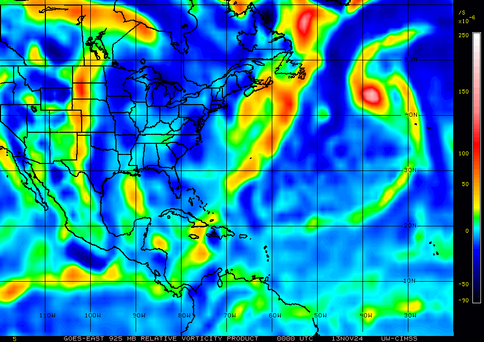
Looking at where the vorticity is located, It is a bit east of where the 8am fix is located

1 likes
The posts in this forum are NOT official forecast and should not be used as such. They are just the opinion of the poster and may or may not be backed by sound meteorological data. They are NOT endorsed by any professional institution or storm2k.org. For official information, please refer to the NHC and NWS products.
Who is online
Users browsing this forum: No registered users and 47 guests