Evening,
How can you have watches and warnings, all the way down to what appears Homestead, Florida City, and Key Largo nothing at all ? And as stated by several in here there has been almost no motion to the north or NW today.
NATL: IMELDA - Post-Tropical - Discussion
Moderator: S2k Moderators
-
Miami Storm Tracker

- Category 4

- Posts: 916
- Age: 68
- Joined: Sun Jun 13, 2010 10:12 pm
- Location: Key Largo, Fla.
- Contact:
-
floridasun
- Tropical Storm

- Posts: 245
- Joined: Tue Sep 14, 2021 3:59 pm
Re: NATL: NINE - Tropical Depression - Discussion
Miami Storm Tracker wrote:Evening,
How can you have watches and warnings, all the way down to what appears Homestead, Florida City, and Key Largo nothing at all ? And as stated by several in here there has been almost no motion to the north or NW today.
remember nhc have this going central part Bahamas make slight turn to left central fl and than move north that why
1 likes
-
Miami Storm Tracker
- Category 4
- Posts: 916
- Age: 68
- Joined: Sun Jun 13, 2010 10:12 pm
- Location: Key Largo, Fla.
- Contact:
Re: NATL: NINE - Tropical Depression - Discussion
At this point a little safe than sorry would be in order, it's only 25 miles between the two points.
0 likes
-
Coolcruiseman
- Tropical Depression

- Posts: 97
- Age: 52
- Joined: Wed Sep 21, 2022 8:10 pm
- Location: Melbourne, FL
Re: NATL: NINE - Tropical Depression - Discussion
Miami Storm Tracker wrote:At this point a little safe than sorry would be in order, it's only 25 miles between the two points.
Could be based on current forecast track. Also outside of “from the Palm Beach/Martin County Line to the Flagler/Volusia County Line” those watches/warnings are coastal waters only currently.
Be interesting if things change with the 11 pm update.
1 likes
-
Miami Storm Tracker
- Category 4
- Posts: 916
- Age: 68
- Joined: Sun Jun 13, 2010 10:12 pm
- Location: Key Largo, Fla.
- Contact:
Re: NATL: NINE - Tropical Depression - Discussion
Yes I agree unless it's the angle and the potential track because you can't get anymore on the coast than we are lol
1 likes
-
cycloneye

- Admin

- Posts: 149720
- Age: 69
- Joined: Thu Oct 10, 2002 10:54 am
- Location: San Juan, Puerto Rico
Re: NATL: NINE - Tropical Depression - Discussion
Have a couple of interesting questions. What happens if it continues to loop around and not move much? Will Humberto pick it up or misses her?
4 likes
Visit the Caribbean-Central America Weather Thread where you can find at first post web cams,radars
and observations from Caribbean basin members Click Here
and observations from Caribbean basin members Click Here

Re: NATL: NINE - Tropical Depression - Discussion
Coolcruiseman wrote:skillz305 wrote:Has it technically been stalling today in its current location right under our noses? I’m completely mind boggled.
Very little movement today since the 11 am update. And no movement since the 8 pm.

So slower movement = greater chance it gets pulled out to sea? That seems to be the consensus.
0 likes
Igor 2010, Sandy 2012, Fay 2014, Gonzalo 2014, Joaquin 2015, Nicole 2016, Humberto 2019, Imelda 2025
I am only a tropical weather enthusiast. My predictions are not official and may or may not be backed by sound meteorological data. For official information, please refer to the NHC and NWS products.
I am only a tropical weather enthusiast. My predictions are not official and may or may not be backed by sound meteorological data. For official information, please refer to the NHC and NWS products.
-
cycloneye
- Admin
- Posts: 149720
- Age: 69
- Joined: Thu Oct 10, 2002 10:54 am
- Location: San Juan, Puerto Rico
Re: NATL: NINE - Tropical Depression - Discussion
Excerpt from 11 PM discussion:
It is notable to point out the system has been moving slower than
anticipated over the last 12-24 hours, and this could have
significant implications on its ultimate track
anticipated over the last 12-24 hours, and this could have
significant implications on its ultimate track
2 likes
Visit the Caribbean-Central America Weather Thread where you can find at first post web cams,radars
and observations from Caribbean basin members Click Here
and observations from Caribbean basin members Click Here
Re: NATL: NINE - Tropical Depression - Discussion
I don't mean to be a Debbie Downer, but I don't see why all the hype for this storm. It's not even a hurricane yet. Am I missing something?
1 likes

Re: NATL: NINE - Tropical Depression - Discussion
cycloneye wrote:Excerpt from 11 PM discussion:It is notable to point out the system has been moving slower than
anticipated over the last 12-24 hours, and this could have
significant implications on its ultimate track
Hey Luis, From just below that in the discussion:
Faster tracks appear to interact more with the upper-level
trough to the west, resulting in a track closer to the Carolina
coastline, while slower tracks largely miss a direct interaction
with this feature, and turn sharply east faster as Hurricane
Humberto approaches from the east, eroding the mid-level ridging
steering TD9 northward. Because it has been moving slower than
expected, its becoming more likely its ultimate track will fall in
the slower and sharper east camp. In response, the overall track
guidance this cycle shifted slower and further east, and the NHC
track forecast was shifted in that direction.
2 likes
Personal Forecast Disclaimer:
The posts in this forum are NOT official forecasts and should not be used as such. They are just the opinion of the poster and may or may not be backed by sound meteorological data. They are NOT endorsed by any professional institution or storm2k.org. For official information, please refer to the NHC and NWS products.
The posts in this forum are NOT official forecasts and should not be used as such. They are just the opinion of the poster and may or may not be backed by sound meteorological data. They are NOT endorsed by any professional institution or storm2k.org. For official information, please refer to the NHC and NWS products.

Re: NATL: NINE - Tropical Depression - Discussion
You can see the naked swirl on the western end of the convection.

6 likes
The following post is NOT an official forecast and should not be used as such. It is just the opinion of the poster and may or may not be backed by sound meteorological data. It is NOT endorsed by any professional institution including storm2k.org For Official Information please refer to the NHC and NWS products.
-
Coolcruiseman
- Tropical Depression
- Posts: 97
- Age: 52
- Joined: Wed Sep 21, 2022 8:10 pm
- Location: Melbourne, FL
Re: NATL: NINE - Tropical Depression - Discussion
The question becomes is there such a thing as too slow? As in could the opening created by Humberto disappear if 9 continues this slow meander for too long?
3 likes

Re: NATL: NINE - Tropical Depression - Discussion
The over all structure is very large. Huge
1 likes

Re: NATL: NINE - Tropical Depression - Discussion
91L... I mean "NINE" is a sloppy hot mess. I was frankly surprised when it was upgraded to T.D. and I still believe calling it such is generous. 1004 mb SLP is fine but the surface wind and pressure gradient is broad and I'll defined. The MLC is displaced north of the LLC. A CDO cannot be maintained nor is there banded convection in relation to a LLC. Sure, there certainly is a sizable broad circulation which is increasingly becoming stretched NNW/SSE. This is indicative of the increasingly deep layer influence to want this indecisive driver to hit the gas pedal and move LOL. And it will, tomorrow. I fully expect a significant convective blow up to occur east or N.E. of Andros Island by tomorrow afternoon. Within that MLC, I suspect the LLC will slip under or redevelop and the slightly better vertical organization finally permitting further pressure falls and improved pressure gradient to justify an upgrade to T.S. Sunday afternoon or evening. I have to think that dry air within a particular layer has been a bigger culprit than moderate southerly upper level winds. The fact that this has remained essentially stationary contrary to forecast is simply a testament to how weak and disorganized it has continued to be.
I'm still in the camp that doubts that this will ever attain hurricane intensity and think that it will remain too weak to impact a legit fujiwhara affect on Humberto, and more apt to simply be absorbed by it instead. That is also the depiction which the 0Z NAM has consistently favored as well (curiously enough).
I'm still in the camp that doubts that this will ever attain hurricane intensity and think that it will remain too weak to impact a legit fujiwhara affect on Humberto, and more apt to simply be absorbed by it instead. That is also the depiction which the 0Z NAM has consistently favored as well (curiously enough).
2 likes
Andy D
(For official information, please refer to the NHC and NWS products.)
(For official information, please refer to the NHC and NWS products.)

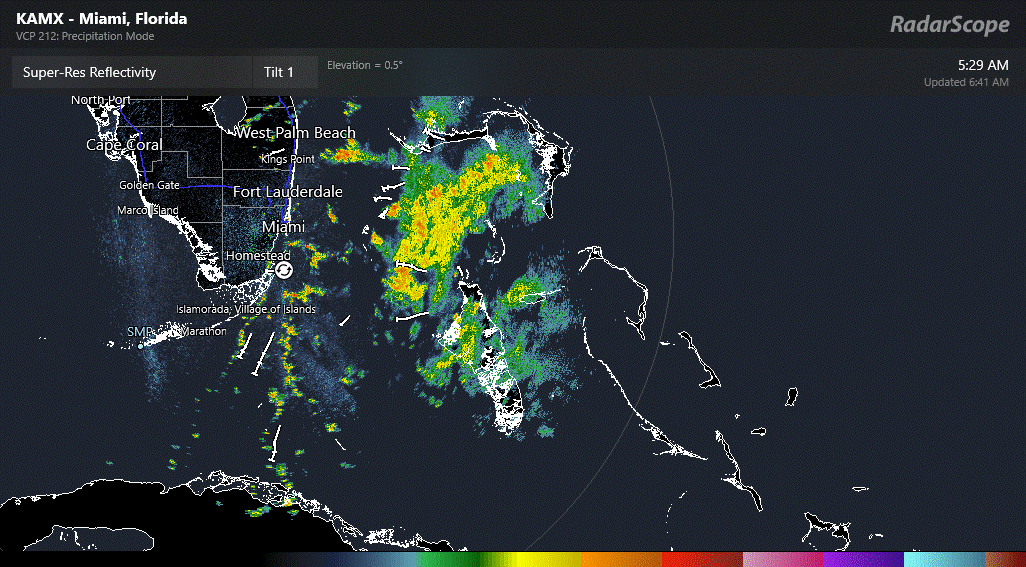
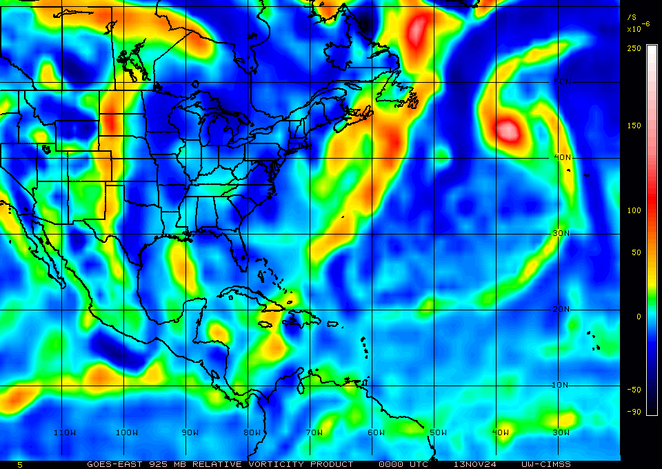
Re: NATL: NINE - Tropical Depression - Discussion
That is about as stalled as it gets
Slightly deepening though
https://www.tropicaltidbits.com/recon/r ... YCLONE.png
Same with that LL vort in the GOM
However, it's starting to fire some convection
https://tropic.ssec.wisc.edu/real-time/ ... g8vor5.GIF
https://weather.cod.edu/satrad/?parms=r ... =undefined
Slightly deepening though
https://www.tropicaltidbits.com/recon/r ... YCLONE.png
Same with that LL vort in the GOM
However, it's starting to fire some convection
https://tropic.ssec.wisc.edu/real-time/ ... g8vor5.GIF
https://weather.cod.edu/satrad/?parms=r ... =undefined
1 likes
Re: NATL: NINE - Tropical Depression - Discussion
Looks like it'll be tracking away from an anticyclone and the LL vort in the GOM is stuck.
Good chance now this will be a nothingburger for the CONUS.
Bahamas still under the gun.
Good chance now this will be a nothingburger for the CONUS.
Bahamas still under the gun.
1 likes

Re: NATL: NINE - Tropical Depression - Discussion
Must be getting a little damp in Cuba!
1 likes
I'm not a meteorologist, I'm an electronics engineer. While I can probably fix your toaster oven, you're not going to learn about storms from me!
New Mexico had no hurricanes. Then I moved to NC right before Fran.....
New Mexico had no hurricanes. Then I moved to NC right before Fran.....
-
Sciencerocks
- Category 5

- Posts: 10193
- Age: 40
- Joined: Thu Jul 06, 2017 1:51 am

Who is online
Users browsing this forum: No registered users and 45 guests