EPAC: ALVIN - Remnant - Discussion

Moderator: S2k Moderators

Message
Author
User avatar
cycloneye
Admin
Admin
Posts: 145255
Age: 68
Joined: Thu Oct 10, 2002 10:54 am
Location: San Juan, Puerto Rico

Re: EPAC: ALVIN - Tropical Storm - Discussion

#81 Postby cycloneye » Thu May 29, 2025 3:34 pm

BULLETIN
Tropical Storm Alvin Advisory Number 5
NWS National Hurricane Center Miami FL EP012025
200 PM MST Thu May 29 2025

...TROPICAL STORM ALVIN CONTINUES TO STRENGTHEN...


SUMMARY OF 200 PM MST...2100 UTC...INFORMATION
----------------------------------------------
LOCATION...15.1N 107.2W
ABOUT 565 MI...910 KM SSE OF THE SOUTHERN TIP OF BAJA CALIFORNIA
MAXIMUM SUSTAINED WINDS...60 MPH...95 KM/H
PRESENT MOVEMENT...NW OR 320 DEGREES AT 12 MPH...19 KM/H
MINIMUM CENTRAL PRESSURE...999 MB...29.50 INCHES


Tropical Storm Alvin Discussion Number 5
NWS National Hurricane Center Miami FL EP012025
200 PM MST Thu May 29 2025

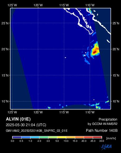
Satellite imagery depicts that Alvin has continued to become better
organized throughout the day, showing convective banding and a
central dense overcast with cold cloud tops near -75C located over
the low-level center. An earlier scatterometer pass shows wind
speeds around 45 kt. Given the improving convective structure since
that pass, and increasing objective satellite intensity estimates,
the initial intensity has increased to 50 kt for this advisory.

The initial motion is 320/10 kt. The storm is expected to continue
moving toward the northwest today, then begin turning toward the
north-northwest tomorrow as it moves around a ridge centered over
central Mexico. By tomorrow night, Alvin will begin moving northward
as it is influenced by a mid-level cut-off low. The NHC track
forecast is very near the previous one.

The storm will remain within a favorable environment of warm sea
surface temperatures and low wind shear over the next 12 hours or
so. Given the latest convective trends and conducive conditions, the
peak intensity forecast has increased this cycle to 60 kt. Tomorrow,
Alvin will begin to move into a hostile environment with cooler
SSTs, higher wind shear, and a drier mid-level airmass which will
induce weakening. Latest model derived IR imagery from both the
ECMWF and GFS depict the system becoming devoid of convection, and
the latest NHC forecast depicts the system becoming a remnant low in
48 h. Thus, there is high confidence that the system will weaken to
a remnant low before it nears the Baja California Peninsula.


FORECAST POSITIONS AND MAX WINDS

INIT 29/2100Z 15.1N 107.2W 50 KT 60 MPH
12H 30/0600Z 16.0N 108.0W 60 KT 70 MPH
24H 30/1800Z 17.6N 108.7W 50 KT 60 MPH
36H 31/0600Z 19.1N 109.0W 40 KT 45 MPH
48H 31/1800Z 20.5N 109.1W 35 KT 40 MPH...POST-TROPICAL
60H 01/0600Z 22.0N 109.2W 25 KT 30 MPH...POST-TROP/REMNT LOW
72H 01/1800Z...DISSIPATED

$$
Forecaster Kelly/Mora
1 likes   
Visit the Caribbean-Central America Weather Thread where you can find at first post web cams,radars
and observations from Caribbean basin members Click Here

User avatar
AnnularCane
S2K Supporter
S2K Supporter
Posts: 2860
Joined: Thu Jun 08, 2006 9:18 am
Location: Wytheville, VA

Re: EPAC: ALVIN - Tropical Storm - Discussion

#82 Postby AnnularCane » Thu May 29, 2025 3:49 pm

DorkyMcDorkface wrote:Solid mid-grade TS. With that being said it kind of floundered and wasted quite a bit of time developing due to how broad the precursor disturbance was, so it probably won't have the time or real estate to make it to hurricane intensity before it reaches a more prohibitive environment in another 12-18 hours or so. GFS was overzealous in spinning it up so rapidly. Euro was far more realistic in this case
https://i.ibb.co/v6LNY3JY/goes18-ir-01-E-1.gif


Seems to be trying to make up for that lost time as best he can. 8-)
2 likes   
"But it never rained rain. It never snowed snow. And it never blew just wind. It rained things like soup and juice. It snowed mashed potatoes and green peas. And sometimes the wind blew in storms of hamburgers." -- Judi Barrett, Cloudy with a Chance of Meatballs

TomballEd
Category 2
Category 2
Posts: 685
Age: 61
Joined: Wed Aug 16, 2023 4:52 pm
Location: Spring/Klein area, not Tomball

Re: EPAC: ALVIN - Tropical Storm - Discussion

#83 Postby TomballEd » Thu May 29, 2025 3:59 pm

60 knots forecast now.
0 likes   

User avatar
Kingarabian
S2K Supporter
S2K Supporter
Posts: 15979
Joined: Sat Aug 08, 2009 3:06 am
Location: Honolulu, Hawaii

Re: EPAC: ALVIN - Tropical Storm - Discussion

#84 Postby Kingarabian » Thu May 29, 2025 4:50 pm

No microwave mentions in the NHC discussions for Alvin. Only ASCAT products.
2 likes   
RIP Kobe Bryant

Sciencerocks
Category 5
Category 5
Posts: 9154
Age: 39
Joined: Thu Jul 06, 2017 1:51 am

Re: EPAC: ALVIN - Tropical Storm - Discussion

#85 Postby Sciencerocks » Thu May 29, 2025 5:41 pm

Image
6 likes   

HurricaneRyan
Category 3
Category 3
Posts: 813
Age: 31
Joined: Sun Dec 05, 2010 3:05 pm

Re: EPAC: ALVIN - Tropical Storm - Discussion

#86 Postby HurricaneRyan » Thu May 29, 2025 5:48 pm

Not a bad first storm tbh. Cute
3 likes   
Kay '22 Hilary '23

Hurricane2000
Tropical Low
Tropical Low
Posts: 30
Joined: Sat Dec 28, 2024 4:50 pm

Re: EPAC: ALVIN - Tropical Storm - Discussion

#87 Postby Hurricane2000 » Thu May 29, 2025 5:55 pm

Interesting how it sort of resembles Patricia 2015 when she was rapidly intensifying
1 likes   
Weather = Cool 8-)

User avatar
Yellow Evan
Professional-Met
Professional-Met
Posts: 16143
Age: 27
Joined: Fri Jul 15, 2011 12:48 pm
Location: Henderson, Nevada/Honolulu, HI
Contact:

Re: EPAC: ALVIN - Tropical Storm - Discussion

#88 Postby Yellow Evan » Thu May 29, 2025 8:51 pm

Nasty dry air intrusion. Likely brought down the winds a bit.
1 likes   

User avatar
cycloneye
Admin
Admin
Posts: 145255
Age: 68
Joined: Thu Oct 10, 2002 10:54 am
Location: San Juan, Puerto Rico

Re: EPAC: ALVIN - Tropical Storm - Discussion

#89 Postby cycloneye » Thu May 29, 2025 9:36 pm

BULLETIN
Tropical Storm Alvin Advisory Number 6
NWS National Hurricane Center Miami FL EP012025
800 PM MST Thu May 29 2025

...ALVIN REMAINS WELL OFFSHORE OF SOUTHWESTERN MEXICO...


SUMMARY OF 800 PM MST...0300 UTC...INFORMATION
----------------------------------------------
LOCATION...16.0N 107.9W
ABOUT 495 MI...795 KM SSE OF THE SOUTHERN TIP OF BAJA CALIFORNIA
MAXIMUM SUSTAINED WINDS...60 MPH...95 KM/H
PRESENT MOVEMENT...NW OR 325 DEGREES AT 12 MPH...19 KM/H
MINIMUM CENTRAL PRESSURE...999 MB...29.50 INCHES


Tropical Storm Alvin Discussion Number 6
NWS National Hurricane Center Miami FL EP012025
800 PM MST Thu May 29 2025

Infrared cloud top temperatures have gradually warmed over the
center of Alvin this evening. Earlier AMSR-2 passive microwave
images showed a ragged convective structure on the west side of the
storm, and recent satellite trends indicate the system may already
be contending with some shear and intrusions of drier air. The
subjective Dvorak classifications and objective intensity estimates
range from 45-55 kt, so the initial intensity is held at 50 kt.

Alvin is still moving to the northwest (325/10 kt) but should turn
north-northwestward and northward on Friday and Saturday toward a
weakness in the ridge created by a cutoff low offshore of Baja
California. The track guidance remains in good agreement, and no
major changes were made to the updated NHC track forecast.

Recent microwave data indicate the storm lacks an inner core, so
Alvin will be susceptible to the negative effects of increasing
shear and drier mid-level air during the next couple of days. In
addition, the track forecast brings Alvin over cooler waters as it
nears the Baja California peninsula. So, gradual weakening is
forecast as the associated convection is likely to become displaced
from the storm center beginning on Friday. This forecast shows
Alvin becoming post-tropical in 36 h and spinning down over the
weekend, in agreement with the global model fields and simulated
satellite imagery.


FORECAST POSITIONS AND MAX WINDS

INIT 30/0300Z 16.0N 107.9W 50 KT 60 MPH
12H 30/1200Z 17.2N 108.5W 45 KT 50 MPH
24H 31/0000Z 18.7N 109.0W 40 KT 45 MPH
36H 31/1200Z 20.3N 109.3W 35 KT 40 MPH...POST-TROPICAL
48H 01/0000Z 21.9N 109.4W 30 KT 35 MPH...POST-TROP/REMNT LOW
60H 01/1200Z 23.7N 109.3W 20 KT 25 MPH...POST-TROP/REMNT LOW
72H 02/0000Z...DISSIPATED

$$
Forecaster Reinhart
0 likes   
Visit the Caribbean-Central America Weather Thread where you can find at first post web cams,radars
and observations from Caribbean basin members Click Here

User avatar
Kingarabian
S2K Supporter
S2K Supporter
Posts: 15979
Joined: Sat Aug 08, 2009 3:06 am
Location: Honolulu, Hawaii

Re: EPAC: ALVIN - Tropical Storm - Discussion

#90 Postby Kingarabian » Thu May 29, 2025 11:14 pm

Okay so at least the NHC still has access to microwave imagery lol. Can't find any online.
0 likes   
RIP Kobe Bryant

Sciencerocks
Category 5
Category 5
Posts: 9154
Age: 39
Joined: Thu Jul 06, 2017 1:51 am

Re: EPAC: ALVIN - Tropical Storm - Discussion

#91 Postby Sciencerocks » Fri May 30, 2025 1:26 am

Image
0 likes   

User avatar
Yellow Evan
Professional-Met
Professional-Met
Posts: 16143
Age: 27
Joined: Fri Jul 15, 2011 12:48 pm
Location: Henderson, Nevada/Honolulu, HI
Contact:

Re: EPAC: ALVIN - Tropical Storm - Discussion

#92 Postby Yellow Evan » Fri May 30, 2025 2:15 am

Trough interaction not nearly as favorable as modeled. This has likely peaked barring a reversal of fortune on that front.
1 likes   

User avatar
cycloneye
Admin
Admin
Posts: 145255
Age: 68
Joined: Thu Oct 10, 2002 10:54 am
Location: San Juan, Puerto Rico

Re: EPAC: ALVIN - Tropical Storm - Discussion

#93 Postby cycloneye » Fri May 30, 2025 4:34 am

Tropical Storm Alvin Discussion Number 7
NWS National Hurricane Center Miami FL EP012025
200 AM MST Fri May 30 2025

Alvin is unraveling quickly. Overnight satellite surface wind data
placed the center of the storm near the southern edge of the cold
cloud tops. The vertical wind shear analysis from CIMSS-UW
estimates that Alvin has entered a region of strong shear. The
initial intensity is lowered slightly to 45 kt, based on the recent
scatterometer observations.

The storm is moving north-northwestward at 9 kt. Alvin should
gradually turn toward the north over the next day or so as it moves
towards a weakness in the ridge. Only minor adjustments have been
made to the official forecast, which lies near the various consensus
aids.

The increasingly hostile environmental conditions are expected to
weaken Alvin further over the next 24 h. Strong vertical wind
shear and cooling sea surface temperatures should cause the storm
to become a post-tropical remnant low by this weekend. No
significant changes were made to the latest NHC intensity forecast.


FORECAST POSITIONS AND MAX WINDS

INIT 30/0900Z 16.6N 108.3W 45 KT 50 MPH
12H 30/1800Z 17.9N 108.8W 40 KT 45 MPH
24H 31/0600Z 19.5N 109.2W 35 KT 40 MPH
36H 31/1800Z 21.1N 109.4W 30 KT 35 MPH...POST-TROP/REMNT LOW
48H 01/0600Z 22.8N 109.5W 25 KT 30 MPH...POST-TROP/REMNT LOW
60H 01/1800Z 24.6N 109.4W 20 KT 25 MPH...POST-TROP/REMNT LOW
72H 02/0600Z...DISSIPATED

$$
Forecaster Bucci
0 likes   
Visit the Caribbean-Central America Weather Thread where you can find at first post web cams,radars
and observations from Caribbean basin members Click Here

User avatar
cycloneye
Admin
Admin
Posts: 145255
Age: 68
Joined: Thu Oct 10, 2002 10:54 am
Location: San Juan, Puerto Rico

Re: EPAC: ALVIN - Tropical Storm - Discussion

#94 Postby cycloneye » Fri May 30, 2025 8:24 am

Holding on but the full demise is comming very soon.

Image
1 likes   
Visit the Caribbean-Central America Weather Thread where you can find at first post web cams,radars
and observations from Caribbean basin members Click Here

TomballEd
Category 2
Category 2
Posts: 685
Age: 61
Joined: Wed Aug 16, 2023 4:52 pm
Location: Spring/Klein area, not Tomball

Re: EPAC: ALVIN - Tropical Storm - Discussion

#95 Postby TomballEd » Fri May 30, 2025 8:28 am

cycloneye wrote:Holding on but the full demise is comming very soon.

https://i.imgur.com/eFpNJbw.gif


Upper level outflow still looks good but mid level shear from the SW is increasing looking at the loop on Tropical Tidbits.
3 likes   

User avatar
cycloneye
Admin
Admin
Posts: 145255
Age: 68
Joined: Thu Oct 10, 2002 10:54 am
Location: San Juan, Puerto Rico

Re: EPAC: ALVIN - Tropical Storm - Discussion

#96 Postby cycloneye » Fri May 30, 2025 9:37 am

Tropical Storm Alvin Discussion Number 8
NWS National Hurricane Center Miami FL EP012025
800 AM MST Fri May 30 2025

Alvin is now moving into an area of stronger south to southwesterly
wind shear, and water vapor imagery shows the cyclone moving into a
progressively drier airmass. The center is estimated to be
underneath the southern portion of the convection. The convective
organization of the cyclone appears to have degraded slightly over
the past 6 hours. Recent AMSR2 and GMI microwave passes show that
the convection in the southern semicircle has completely eroded. CI
numbers from TAFB and SAB both remain at T-3.0/45 kt, and objective
intensity estimates from UW-CIMSS are a bit higher. Given the large
area of 40-45 kt winds on the ASCAT pass from 0438 UTC this morning,
45 kt is held for this advisory.

The initial motion is estimated to be northwest, or 325/9-kt.
Alvin is forecast to turn northward over the next day or so as it
moves through a weakness in the subtropical ridge, toward the east
side of a mid-level cutoff low located just west of Baja
California. Little change is made to the previous NHC track
prediction, which lies down the middle of the consensus model
envelope.

Alvin will continue moving into an increasingly hostile environment
of very strong wind shear, dry air, and sea-surface temperatures
that will drop below 26C along Alvin's path in about 12 hours.
These conditions will lead to Alvin losing its convection by
Saturday, which is depicted by the GFS and ECMWF simulated
satellite imagery. There are no significant changes to the NHC
intensity forecast, and Alvin is forecast to degenerate to a
remnant low in about 24 hours, with dissipation in a little over 2
days.


FORECAST POSITIONS AND MAX WINDS

INIT 30/1500Z 17.4N 108.8W 45 KT 50 MPH
12H 31/0000Z 18.7N 109.1W 35 KT 40 MPH
24H 31/1200Z 20.3N 109.4W 30 KT 35 MPH...POST-TROP/REMNT LOW
36H 01/0000Z 21.8N 109.5W 25 KT 30 MPH...POST-TROP/REMNT LOW
48H 01/1200Z 23.5N 109.5W 20 KT 25 MPH...POST-TROP/REMNT LOW
60H 02/0000Z...DISSIPATED

$$
Forecaster Hagen
0 likes   
Visit the Caribbean-Central America Weather Thread where you can find at first post web cams,radars
and observations from Caribbean basin members Click Here

Sciencerocks
Category 5
Category 5
Posts: 9154
Age: 39
Joined: Thu Jul 06, 2017 1:51 am

Re: EPAC: ALVIN - Tropical Storm - Discussion

#97 Postby Sciencerocks » Fri May 30, 2025 1:52 pm

Image
0 likes   

User avatar
galaxy401
Category 5
Category 5
Posts: 2419
Age: 30
Joined: Sat Aug 25, 2012 9:04 pm
Location: Casa Grande, Arizona

Re: EPAC: INVEST 90E - Discussion

#98 Postby galaxy401 » Fri May 30, 2025 3:39 pm

AnnularCane wrote:
galaxy401 wrote:Anyone else not able to access the satellite view for the East Pacific on the NHC website? It's annoying me since I have to go to other sites including here to see them.


The satellites are there, but I don't see any floaters. Is that what you're looking for?

Tropical Tidbits is typically my go-to site.

https://www.tropicaltidbits.com/sat/


Late reply but wanted to be more specific.

On the NHC website, when you click anywhere on the basin, it changes to satellite view so you can see the actual disturbances. However, now when I click on it, it just doesn't do it anymore. This occurs in both basins now.
0 likes   
Got my eyes on moving right into Hurricane Alley: Florida.

User avatar
cycloneye
Admin
Admin
Posts: 145255
Age: 68
Joined: Thu Oct 10, 2002 10:54 am
Location: San Juan, Puerto Rico

Re: EPAC: ALVIN - Tropical Storm - Discussion

#99 Postby cycloneye » Fri May 30, 2025 3:46 pm

Tropical Storm Alvin Discussion Number 9
NWS National Hurricane Center Miami FL EP012025
200 PM MST Fri May 30 2025

The satellite presentation of Alvin has gradually degraded today.
Alvin is entering an environment of strong south-southwesterly wind
shear. Although much of the convection has been pushed off to the
north and become elongated, the low-level center still appears to be
underneath the southernmost portion of the central dense overcast.
A pair of recent ASCAT passes missed the center, but still provided
useful information that shows somewhat larger 34-kt radii, so these
have been been expanded a bit. The ASCAT data show winds up to 40
kt about 50 n mi east of the center, but there is a good chance that
stronger winds are still occurring slightly closer to the center
where there was a gap in ASCAT data. The latest subjective intensity
estimates from TAFB and SAB are T-2.5/35 kt, and the latest
objective intensity estimates from UW-CIMSS are in the 41-47 kt
range. The intensity is held at 45 kt for this advisory since the
low-level center has not emerged from underneath the central dense
overcast yet, and based on the ASCAT data.

The initial motion is estimated to be north-northwest, or 335/9 kt.
Alvin is forecast to turn northward tonight as it moves through a
weakness in the subtropical ridge, toward the east side of a
mid-level cutoff low located just west of Baja California. Little
change is made to the previous NHC track prediction, which lies down
the middle of the consensus model envelope.

Alvin will continue moving into an increasingly hostile environment
of very strong wind shear, dry air, and sea-surface temperatures
that will drop below 26C along Alvin's path in about 6 hours.
These conditions should lead to Alvin losing its convection on
Saturday, which is depicted by the GFS and ECMWF simulated
satellite imagery. There are no significant changes to the NHC
intensity forecast, and Alvin is forecast to degenerate to a
remnant low in about 24 hours, with dissipation predicted to
occur in about 2 days.


FORECAST POSITIONS AND MAX WINDS

INIT 30/2100Z 18.1N 109.0W 45 KT 50 MPH
12H 31/0600Z 19.4N 109.3W 35 KT 40 MPH
24H 31/1800Z 20.8N 109.5W 30 KT 35 MPH...POST-TROP/REMNT LOW
36H 01/0600Z 22.4N 109.4W 25 KT 30 MPH...POST-TROP/REMNT LOW
48H 01/1800Z...DISSIPATED

$$
Forecaster Hagen
0 likes   
Visit the Caribbean-Central America Weather Thread where you can find at first post web cams,radars
and observations from Caribbean basin members Click Here

User avatar
Kingarabian
S2K Supporter
S2K Supporter
Posts: 15979
Joined: Sat Aug 08, 2009 3:06 am
Location: Honolulu, Hawaii

Re: EPAC: ALVIN - Tropical Storm - Discussion

#100 Postby Kingarabian » Fri May 30, 2025 6:31 pm

Most recent AMSR2 pass shows the core pretty much eroded to the south.

Image
0 likes   
RIP Kobe Bryant


Return to “2025”

Who is online

Users browsing this forum: No registered users and 6 guests