NATL: MELISSA - Aftermath - Discussion: Josh Morgerman video of Melissa is up

Moderator: S2k Moderators

Message
Author
User avatar
eastcoastFL
Category 5
Category 5
Posts: 3996
Age: 43
Joined: Thu Apr 12, 2007 12:29 pm
Location: Palm City, FL

Re: NATL: MELISSA - Hurricane - Discussion

#801 Postby eastcoastFL » Sat Oct 25, 2025 10:18 pm

BobHarlem wrote:Long duration radar loop of Melissa (since eye was discernible on radar) until now.

https://i.postimg.cc/qvKw9sDy/Jamaica-Radar-Melissa-10.gif


Where were you able to access the radar? The Jamaican radar site hasn't been working for me.
0 likes   
Personal Forecast Disclaimer:
The posts in this forum are NOT official forecast and should not be used as such. They are just the opinion of the poster and may or may not be backed by sound meteorological data. They are NOT endorsed by any professional institution or storm2k.org. For official information, please refer to the NHC and NWS products.

Fancy1002
Category 1
Category 1
Posts: 322
Joined: Sun Dec 25, 2022 3:47 pm

Re: NATL: MELISSA - Hurricane - Discussion

#802 Postby Fancy1002 » Sat Oct 25, 2025 10:19 pm

Unless something goes wrong overnight, Melissa is going to be a terrifying beauty in the morning.
5 likes   

User avatar
eastcoastFL
Category 5
Category 5
Posts: 3996
Age: 43
Joined: Thu Apr 12, 2007 12:29 pm
Location: Palm City, FL

Re: NATL: MELISSA - Hurricane - Discussion

#803 Postby eastcoastFL » Sat Oct 25, 2025 10:22 pm

Such a horrific and beautiful storm. Nature can be such an amazing beast.


Image
3 likes   
Personal Forecast Disclaimer:
The posts in this forum are NOT official forecast and should not be used as such. They are just the opinion of the poster and may or may not be backed by sound meteorological data. They are NOT endorsed by any professional institution or storm2k.org. For official information, please refer to the NHC and NWS products.

CrazyC83
Professional-Met
Professional-Met
Posts: 34308
Joined: Tue Mar 07, 2006 11:57 pm
Location: Deep South, for the first time!

Re: NATL: MELISSA - Hurricane - Discussion

#804 Postby CrazyC83 » Sat Oct 25, 2025 10:23 pm

Fancy1002 wrote:Unless something goes wrong overnight, Melissa is going to be a terrifying beauty in the morning.


Wouldn't be surprised to see it reach category 5 sometime tomorrow, possibly fairly early if the rate picks up (and if the eye opens up it just might).
2 likes   

User avatar
Stormybajan
Category 1
Category 1
Posts: 453
Joined: Thu May 20, 2021 3:21 pm
Location: Windward Islands

Re: NATL: MELISSA - Hurricane - Discussion

#805 Postby Stormybajan » Sat Oct 25, 2025 10:23 pm

Major Hurricane Melissa currently has a heart shaped eye, however this potentially catastrophic situation with my fellow caribbean island in Jamaica is nothing to show love about right now. The rainfall is what worries me most plus the prolonged effects of extremely powerful winds. This could take months to recover from if that nhc forecast goes as expected! A slow moving cat 5??? No one ever wants to be in the middle of that :(
Image
Last edited by Stormybajan on Sat Oct 25, 2025 10:25 pm, edited 3 times in total.
3 likes   
Sad West Indies and Manchester United fan ⚽️

User avatar
blp
Category 5
Category 5
Posts: 2880
Age: 47
Joined: Thu Sep 09, 2004 7:51 pm
Location: Miami, FL
Contact:

Re: NATL: MELISSA - Hurricane - Discussion

#806 Postby blp » Sat Oct 25, 2025 10:23 pm

eastcoastFL wrote:
BobHarlem wrote:Long duration radar loop of Melissa (since eye was discernible on radar) until now.

https://i.postimg.cc/qvKw9sDy/Jamaica-Radar-Melissa-10.gif


Where were you able to access the radar? The Jamaican radar site hasn't been working for me.


Brian Mcnoldy Radar site:

https://bmcnoldy.earth.miami.edu/tropics/radar/
0 likes   
The following post is NOT an official forecast and should not be used as such. It is just the opinion of the poster and may or may not be backed by sound meteorological data. It is NOT endorsed by any professional institution including storm2k.org For Official Information please refer to the NHC and NWS products.

Hurricane Mike
Category 2
Category 2
Posts: 675
Joined: Tue Apr 10, 2018 7:44 am

Re: NATL: MELISSA - Hurricane - Discussion

#807 Postby Hurricane Mike » Sat Oct 25, 2025 10:24 pm

0 likes   

BobHarlem
Category 5
Category 5
Posts: 2566
Joined: Thu Oct 20, 2005 6:11 pm

Re: NATL: MELISSA - Hurricane - Discussion

#808 Postby BobHarlem » Sat Oct 25, 2025 10:24 pm

Blown Away wrote:
BobHarlem wrote:Long duration radar loop of Melissa (since eye was discernible on radar) until now.

https://i.postimg.cc/qvKw9sDy/Jamaica-Radar-Melissa-10.gif


Bob can you provide the radar link? Thanks..


https://flhurricane.com/imageanimator.php?961
1 likes   

User avatar
weeniepatrol
Category 5
Category 5
Posts: 1339
Joined: Sat Aug 22, 2020 5:30 pm
Location: WA State

Re: NATL: MELISSA - Hurricane - Discussion

#809 Postby weeniepatrol » Sat Oct 25, 2025 10:26 pm

Image
5 likes   

User avatar
Hypercane_Kyle
Category 5
Category 5
Posts: 3465
Joined: Sat Mar 07, 2015 7:58 pm
Location: Cape Canaveral, FL

Re: NATL: MELISSA - Hurricane - Discussion

#810 Postby Hypercane_Kyle » Sat Oct 25, 2025 10:27 pm

Absolutely horrific situation unfolding tonight.
3 likes   
My posts are my own personal opinion, defer to the National Hurricane Center (NHC) and other NOAA products for decision making during hurricane season.

User avatar
WaveBreaking
Category 2
Category 2
Posts: 709
Joined: Sun Jun 30, 2024 11:33 am
Location: US

Re: NATL: MELISSA - Hurricane - Discussion

#811 Postby WaveBreaking » Sat Oct 25, 2025 10:29 pm

Travorum wrote:
Also an interesting note from the last VDM, I'm not sure if this has any implication on intensification as I've never seen it before:

EYEWALL APPEARS SQUARE ON RADAR SIGNATURE


Probably means that there's strong mesovorticies in the eye that are making it polygonal in shape. When their winds mix w the rest of the eyewall, the eye becomes round again and the windspeed goes up.

I remember seeing this happen with hurricanes Idalia and Helene.
Image
6 likes   
I am NOT a professional meteorologist, so take all of my posts with a grain of salt. My opinions are mine and mine alone.

hurricanes1234
Category 5
Category 5
Posts: 2908
Joined: Sat Jul 28, 2012 6:19 pm
Location: Trinidad and Tobago

Re: NATL: MELISSA - Hurricane - Discussion

#812 Postby hurricanes1234 » Sat Oct 25, 2025 10:29 pm

Close-up of the heart-shaped eye with abundant lightning :eek:

Image
17 likes   

User avatar
galaxy401
Category 5
Category 5
Posts: 2446
Age: 30
Joined: Sat Aug 25, 2012 9:04 pm
Location: Casa Grande, Arizona

Re: NATL: MELISSA - Hurricane - Discussion

#813 Postby galaxy401 » Sat Oct 25, 2025 10:30 pm

Melissa single-handedly making the Caribbean from a graveyard this season to featuring potentially the most intense storm worldwide for the year.
10 likes   
Got my eyes on moving right into Hurricane Alley: Florida.

Fancy1002
Category 1
Category 1
Posts: 322
Joined: Sun Dec 25, 2022 3:47 pm

Re: NATL: MELISSA - Hurricane - Discussion

#814 Postby Fancy1002 » Sat Oct 25, 2025 10:31 pm

CrazyC83 wrote:
Fancy1002 wrote:Unless something goes wrong overnight, Melissa is going to be a terrifying beauty in the morning.


Wouldn't be surprised to see it reach category 5 sometime tomorrow, possibly fairly early if the rate picks up (and if the eye opens up it just might).

Agreed, I wouldn’t be surprised if that’s what I wake up to in about nine hours. Then the question is where will it peek at. We can only hope that it doesn’t peak close to landfall.
1 likes   

User avatar
mrbagyo
Category 5
Category 5
Posts: 3962
Age: 33
Joined: Thu Apr 12, 2012 9:18 am
Location: 14.13N 120.98E
Contact:

Re: NATL: MELISSA - Hurricane - Discussion

#815 Postby mrbagyo » Sat Oct 25, 2025 10:35 pm

Image
4 likes   
The posts in this forum are NOT official forecast and should not be used as such. They are just the opinion of the poster and may or may not be backed by sound meteorological data. They are NOT endorsed by any professional institution or storm2k.org. For official information, please refer to RSMC, NHC and NWS products.

User avatar
Iceresistance
Category 5
Category 5
Posts: 9434
Age: 22
Joined: Sat Oct 10, 2020 9:45 am
Location: Tecumseh, OK/Norman, OK

Re: NATL: MELISSA - Hurricane - Discussion

#816 Postby Iceresistance » Sat Oct 25, 2025 10:38 pm

Melissa's eye temperature increased from -50.85C to -17.3C in less than 30 minutes. Absolutely insane, it literally shot up like a rocket
9 likes   
Bill 2015 & Beta 2020

Winter 2020-2021 :cold:

All observations are in Tecumseh, OK unless otherwise noted.

Winter posts are focused mainly for Oklahoma & Texas.

Take any of my forecasts with a grain of salt, refer to the NWS, SPC, and NHC for official information

Never say Never with weather! Because ANYTHING is possible!

User avatar
Woofde
Category 2
Category 2
Posts: 558
Joined: Tue Jul 06, 2021 11:33 am

Re: NATL: MELISSA - Hurricane - Discussion

#817 Postby Woofde » Sat Oct 25, 2025 10:54 pm

Iceresistance wrote:Melissa's eye temperature increased from -50.85C to -17.3C in less than 30 minutes. Absolutely insane, it literally shot up like a rocket
I doubt it spends much time at Category 3. Everything is set up for some explosive intensification.
6 likes   

User avatar
Kazmit
Category 5
Category 5
Posts: 2258
Age: 22
Joined: Mon Jul 25, 2016 8:49 am
Location: Bermuda

Re: NATL: MELISSA - Hurricane - Discussion

#818 Postby Kazmit » Sat Oct 25, 2025 10:58 pm

The size of the CDO has absolutely ballooned.
4 likes   
Igor 2010, Sandy 2012, Fay 2014, Gonzalo 2014, Joaquin 2015, Nicole 2016, Humberto 2019, Imelda 2025

I am only a tropical weather enthusiast. My predictions are not official and may or may not be backed by sound meteorological data. For official information, please refer to the NHC and NWS products.

Keldeo1997
Category 2
Category 2
Posts: 688
Joined: Fri Oct 11, 2019 11:35 pm

Re: NATL: MELISSA - Hurricane - Discussion

#819 Postby Keldeo1997 » Sat Oct 25, 2025 11:10 pm

3 likes   

User avatar
FireRat
Category 5
Category 5
Posts: 1274
Age: 38
Joined: Sun Sep 26, 2010 11:38 pm
Location: North Carolina

Re: NATL: MELISSA - Hurricane - Discussion

#820 Postby FireRat » Sat Oct 25, 2025 11:15 pm

2025-ing on 10/25/25 :double:
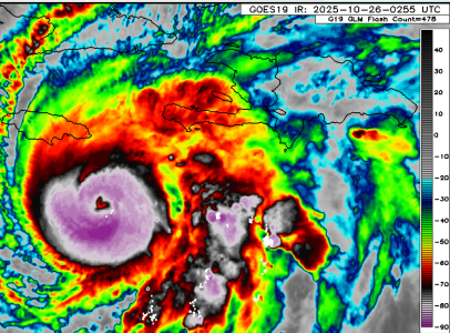
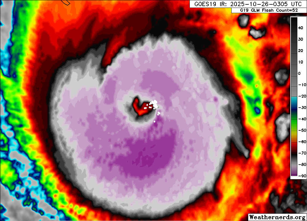
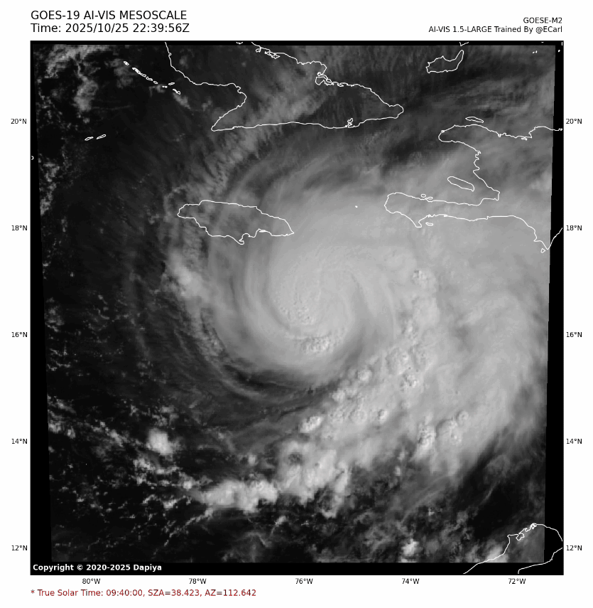
The events of tonight are only the beginning I'm afraid, we will probably look back on this moment and tomorrow's day as the time Melissa went absolutely guano crazy! The events of tonight are nothing short of extraordinary, and Jamaica really needs to be bracing for impact - from likely Cat 5 winds to a Harvey-like deluge but over mountainous terrain.

2025 saved the worst for last, after playing nice, it's now stealthily come up to deliver a devastating strike.
This thing is absolutely bombing right now, very reminiscent of Otis 2 years to the day. WOW.
6 likes   
Georges '98, Irene '99, Frances '04, Jeanne '04, Katrina '05, Wilma '05, Gustav '08, Isaac '12, Matthew '16, Florence '18, Michael '18, Ian '22


Return to “2025”

Who is online

Users browsing this forum: No registered users and 13 guests