NATL: MELISSA - Aftermath - Discussion
Moderator: S2k Moderators

Re: NATL: MELISSA - Hurricane - Discussion
Crazy sight to wake up to this morning. But now it looks like an EWRC or eyewall meld is already starting, based on some developments on the east side of the CDO. Lines up with an occasional outer eyewall on that radar loop.
1 likes
Irene '11 Sandy '12 Hermine '16 5/15/2018 Derecho Fay '20 Isaias '20 Elsa '21 Henri '21 Ida '21
I am only a meteorology enthusiast who knows a decent amount about tropical cyclones. Look to the professional mets, the NHC, or your local weather office for the best information.
I am only a meteorology enthusiast who knows a decent amount about tropical cyclones. Look to the professional mets, the NHC, or your local weather office for the best information.
-
Stormgodess

- Category 1

- Posts: 316
- Joined: Mon Sep 14, 2020 1:31 am
Re: NATL: MELISSA - Hurricane - Discussion
Will we be getting any updated surge prediction maps?
0 likes


-
MEANINGLESS_NUMBERS
- Category 2

- Posts: 503
- Joined: Mon Nov 02, 2020 1:43 pm
Re: NATL: MELISSA - Hurricane - Discussion
GCANE wrote:Up to 40" rain on the eastern end of Jamaica
https://x.com/NHC_Atlantic/status/1982374720411451873
Forty more inches. It has already been raining for two days.
0 likes
Emily '87, Felix '95, Gert '99, Fabian '03, Humberto '19, Paulette '20, Teddy '20, Fiona '22, Lee '23, Ernesto '24, Humberto/Imelda '25
-
mrbagyo

- Category 5

- Posts: 3998
- Age: 33
- Joined: Thu Apr 12, 2012 9:18 am
- Location: 14.13N 120.98E
- Contact:
Re: NATL: MELISSA - Hurricane - Discussion
Convection has fully wrapped on the weaker NE sector again
Kermit is only about 1 hour+ away.

Kermit is only about 1 hour+ away.
3 likes
The posts in this forum are NOT official forecast and should not be used as such. They are just the opinion of the poster and may or may not be backed by sound meteorological data. They are NOT endorsed by any professional institution or storm2k.org. For official information, please refer to RSMC, NHC and NWS products.
Re: NATL: MELISSA - Hurricane - Discussion
mrbagyo wrote:Convection has fully wrapped on the weaker NE sector again
Kermit is only about 1 hour+ away.
https://s12.gifyu.com/images/b3neZ.gif
I have never seen vortices on the feeder band like that.
4 likes

Re: NATL: MELISSA - Hurricane - Discussion
GCANE wrote:mrbagyo wrote:Convection has fully wrapped on the weaker NE sector again
Kermit is only about 1 hour+ away.
https://s12.gifyu.com/images/b3neZ.gif
I have never seen vortices on the feeder band like that.
Structurally she reminds me quite a lot of Beryl with the massive feeder band and these vortices.
2 likes
-
mrbagyo
- Category 5
- Posts: 3998
- Age: 33
- Joined: Thu Apr 12, 2012 9:18 am
- Location: 14.13N 120.98E
- Contact:
Re: NATL: MELISSA - Hurricane - Discussion
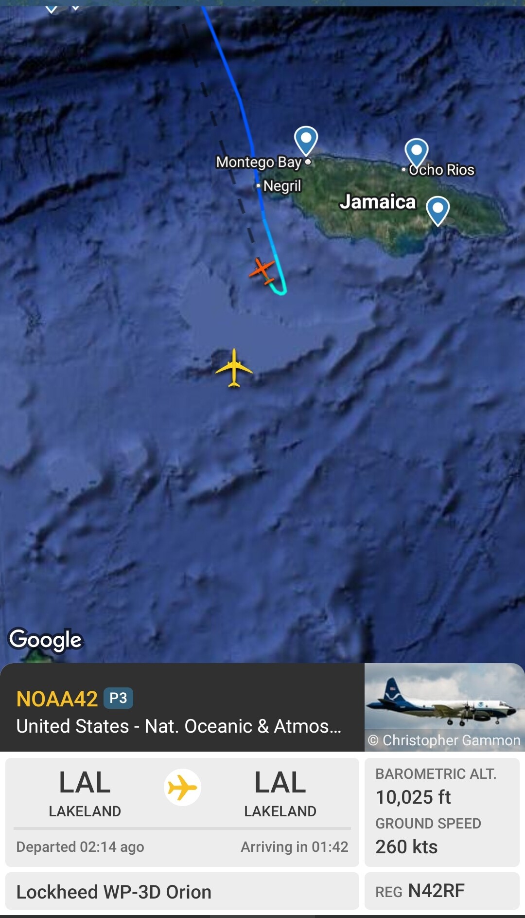
Why it appears Kermit's making a UTurn
0 likes
The posts in this forum are NOT official forecast and should not be used as such. They are just the opinion of the poster and may or may not be backed by sound meteorological data. They are NOT endorsed by any professional institution or storm2k.org. For official information, please refer to RSMC, NHC and NWS products.

Re: NATL: MELISSA - Hurricane - Discussion
Melissa looks incredible, I think recon is gonna find a very extreme storm.
0 likes
Re: NATL: MELISSA - Hurricane - Discussion
mrbagyo wrote:Why it appears Kermit's making a UTurn
https://s12.gifyu.com/images/b3ubq.jpg
Looks like it's travelling south again so maybe it's all good.
0 likes
Re: NATL: MELISSA - Hurricane - Discussion
Raw T# back up to 7.5, CDO at -76C and the eye temp up to its highest value so far of 15.7C. Looks like recon is arriving at the perfect time.
1 likes
Re: NATL: MELISSA - Hurricane - Discussion
It shouldn’t be too long before we get our first pass.
0 likes
-
mrbagyo
- Category 5
- Posts: 3998
- Age: 33
- Joined: Thu Apr 12, 2012 9:18 am
- Location: 14.13N 120.98E
- Contact:
Re: NATL: MELISSA - Hurricane - Discussion
948.9 extrapolated
0 likes
The posts in this forum are NOT official forecast and should not be used as such. They are just the opinion of the poster and may or may not be backed by sound meteorological data. They are NOT endorsed by any professional institution or storm2k.org. For official information, please refer to RSMC, NHC and NWS products.
Re: NATL: MELISSA - Hurricane - Discussion
I’m guessing she’s somewhere around 940 mb and 125-130 kts.
Edit: 949 extrap
Edit: 949 extrap
0 likes
-
eastcoastFL

- Category 5
- Posts: 3996
- Age: 44
- Joined: Thu Apr 12, 2007 12:29 pm
- Location: Palm City, FL
Re: NATL: MELISSA - Hurricane - Discussion
The wind field is still extremely small with hurricane force wines reaching out just 25 miles from center. The surge and rain is still going to be the biggest issue but at least the worst of the winds will be somewhat isolated.
0 likes
Personal Forecast Disclaimer:
The posts in this forum are NOT official forecast and should not be used as such. They are just the opinion of the poster and may or may not be backed by sound meteorological data. They are NOT endorsed by any professional institution or storm2k.org. For official information, please refer to the NHC and NWS products.
The posts in this forum are NOT official forecast and should not be used as such. They are just the opinion of the poster and may or may not be backed by sound meteorological data. They are NOT endorsed by any professional institution or storm2k.org. For official information, please refer to the NHC and NWS products.
-
otowntiger
- Category 5
- Posts: 1932
- Joined: Tue Aug 31, 2004 7:06 pm
Re: NATL: MELISSA - Hurricane - Discussion
eastcoastFL wrote:The wind field is still extremely small with hurricane force wines reaching out just 25 miles from center. The surge and rain is still going to be the biggest issue but at least the worst of the winds will be somewhat isolated.
I was noticing that too. This is a very compact storm- similar to Andrew
2 likes
-
TheDreamTraveler

- Category 2
- Posts: 645
- Joined: Sun Aug 22, 2010 3:10 am
- Location: PA
Re: NATL: MELISSA - Hurricane - Discussion
eastcoastFL wrote:The wind field is still extremely small with hurricane force wines reaching out just 25 miles from center. The surge and rain is still going to be the biggest issue but at least the worst of the winds will be somewhat isolated.
It still has almost 2 days to expand its wind field before it makes landfall
2 likes
-
cheezyWXguy

- Category 5
- Posts: 6282
- Joined: Mon Feb 13, 2006 12:29 am
- Location: Dallas, TX
Re: NATL: MELISSA - Hurricane - Discussion
Think that persistent burst on the se side is associated with the temporary slowdown in pressure drops. Maybe a little dry air trying to get into the circulation, though I doubt it would reach the core. Just seems like the expected stair stepping that was pointed out last night.
1 likes
Who is online
Users browsing this forum: No registered users and 60 guests