
92W INVEST 250920 1200 8.9N 145.0E WPAC 15 0
WPAC: BUALOI - Post-Tropical
Moderator: S2k Moderators
WPAC: BUALOI - Post-Tropical
Last edited by Hayabusa on Thu Sep 25, 2025 1:50 pm, edited 4 times in total.
0 likes
ヤンデレ女が寝取られるているのを見たい!!!
ECMWF ensemble NWPAC plots: https://ecmwfensnwpac.imgbb.com/
Multimodel NWPAC plots: https://multimodelnwpac.imgbb.com/
GFS Ensemble NWPAC plots (16 & 35 day forecast): https://gefsnwpac.imgbb.com/
Plots updated automatically
ECMWF ensemble NWPAC plots: https://ecmwfensnwpac.imgbb.com/
Multimodel NWPAC plots: https://multimodelnwpac.imgbb.com/
GFS Ensemble NWPAC plots (16 & 35 day forecast): https://gefsnwpac.imgbb.com/
Plots updated automatically
Re: WPAC: INVEST 92W
This is the one Euro AI has been showing for many runs already, JMA already marked it as LPA since 06z. Depending on Neoguri's movement, like a failed recurve and then a westward track would inhibit development of this system.
1 likes
ヤンデレ女が寝取られるているのを見たい!!!
ECMWF ensemble NWPAC plots: https://ecmwfensnwpac.imgbb.com/
Multimodel NWPAC plots: https://multimodelnwpac.imgbb.com/
GFS Ensemble NWPAC plots (16 & 35 day forecast): https://gefsnwpac.imgbb.com/
Plots updated automatically
ECMWF ensemble NWPAC plots: https://ecmwfensnwpac.imgbb.com/
Multimodel NWPAC plots: https://multimodelnwpac.imgbb.com/
GFS Ensemble NWPAC plots (16 & 35 day forecast): https://gefsnwpac.imgbb.com/
Plots updated automatically
-
mrbagyo

- Category 5

- Posts: 4002
- Age: 33
- Joined: Thu Apr 12, 2012 9:18 am
- Location: 14.13N 120.98E
- Contact:
Re: WPAC: INVEST 92W
Hayabusa wrote:92W INVEST 250920 1200 8.9N 145.0E WPAC 15 0
Im more invested on this system - there's just more untapped energy along its projected path. Early development or destruction will also hinge on the shear induced by the outflow of Ragasa and potentially much later on by Neoguri
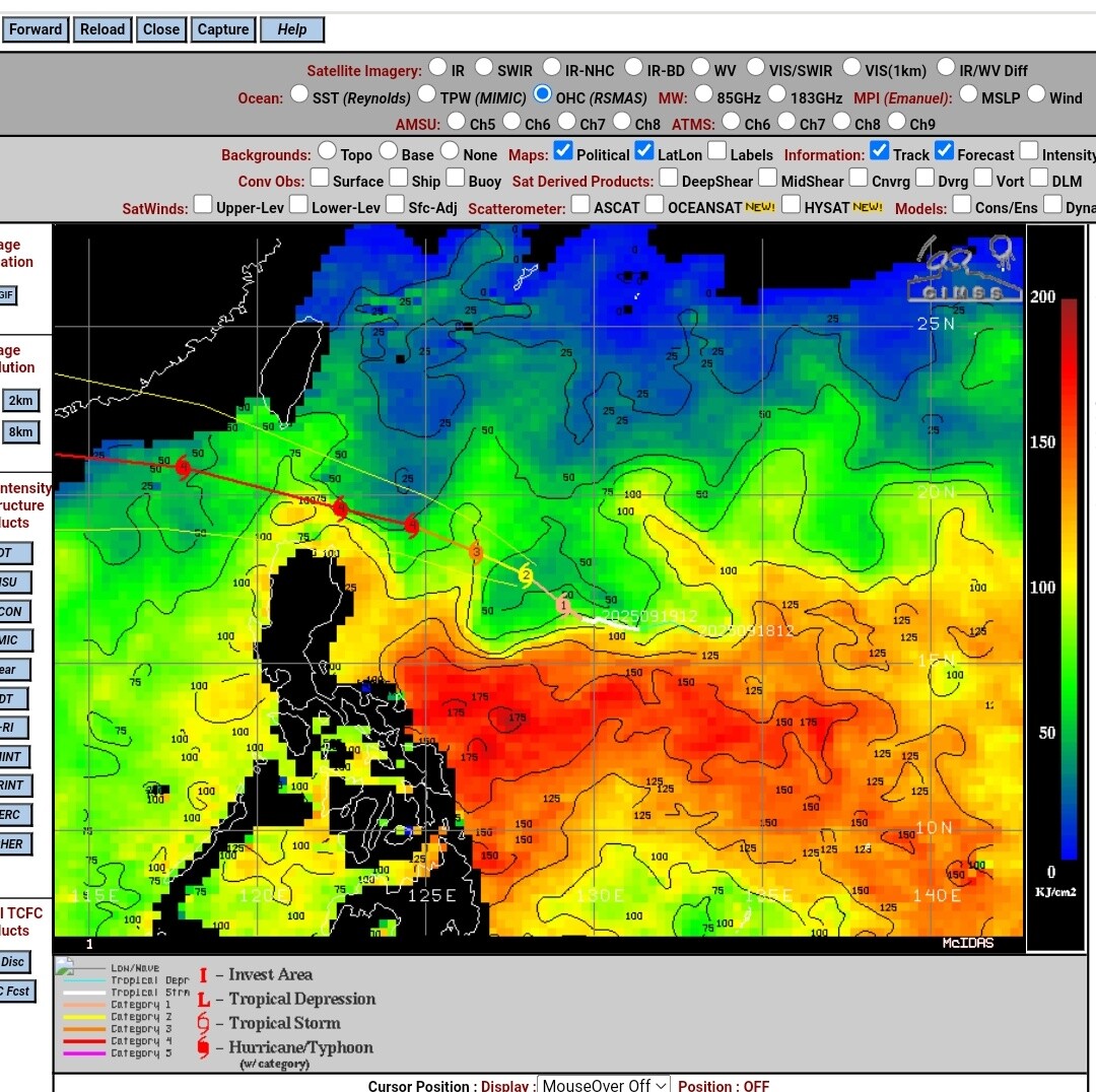
more than 12 hrs old scatterometer pass
0 likes
The posts in this forum are NOT official forecast and should not be used as such. They are just the opinion of the poster and may or may not be backed by sound meteorological data. They are NOT endorsed by any professional institution or storm2k.org. For official information, please refer to RSMC, NHC and NWS products.
Re: WPAC: INVEST 92W
Euro AI 12Z a TS traversing north of northern Samar, then Bicol Region to Mimaropa, then just south of the capital region.
0 likes
ヤンデレ女が寝取られるているのを見たい!!!
ECMWF ensemble NWPAC plots: https://ecmwfensnwpac.imgbb.com/
Multimodel NWPAC plots: https://multimodelnwpac.imgbb.com/
GFS Ensemble NWPAC plots (16 & 35 day forecast): https://gefsnwpac.imgbb.com/
Plots updated automatically
ECMWF ensemble NWPAC plots: https://ecmwfensnwpac.imgbb.com/
Multimodel NWPAC plots: https://multimodelnwpac.imgbb.com/
GFS Ensemble NWPAC plots (16 & 35 day forecast): https://gefsnwpac.imgbb.com/
Plots updated automatically
Re: WPAC: INVEST 92W
mrbagyo wrote:Hayabusa wrote:92W INVEST 250920 1200 8.9N 145.0E WPAC 15 0
Im more invested on this system - there's just more untapped energy along its projected path. Early development or destruction will also hinge on the shear induced by the outflow of Ragasa and potentially much later on by Neoguri
https://s14.gifyu.com/images/bTPTu.jpg
more than 12 hrs old scatterometer pass
https://s14.gifyu.com/images/bTP3S.png
If Euro AI is right it's a rather fast moving system so it could be hard to tap that potential.
0 likes
ヤンデレ女が寝取られるているのを見たい!!!
ECMWF ensemble NWPAC plots: https://ecmwfensnwpac.imgbb.com/
Multimodel NWPAC plots: https://multimodelnwpac.imgbb.com/
GFS Ensemble NWPAC plots (16 & 35 day forecast): https://gefsnwpac.imgbb.com/
Plots updated automatically
ECMWF ensemble NWPAC plots: https://ecmwfensnwpac.imgbb.com/
Multimodel NWPAC plots: https://multimodelnwpac.imgbb.com/
GFS Ensemble NWPAC plots (16 & 35 day forecast): https://gefsnwpac.imgbb.com/
Plots updated automatically
-
cycloneye

- Admin

- Posts: 149843
- Age: 69
- Joined: Thu Oct 10, 2002 10:54 am
- Location: San Juan, Puerto Rico
Re: WPAC: INVEST 92W
1 likes
Visit the Caribbean-Central America Weather Thread where you can find at first post web cams,radars
and observations from Caribbean basin members Click Here
and observations from Caribbean basin members Click Here
-
StormWeather

- Category 1

- Posts: 477
- Joined: Wed Jun 05, 2024 2:34 pm
Re: WPAC: INVEST 92W
And the next international name is Bualoi.
0 likes
Just an average cyclone tracker
The posts in this forum are NOT official forecasts and should not be used as such. They are just the opinion of the poster and may or may not be backed by sound meteorological data. They are NOT endorsed by any professional institution or storm2k.org. For official information, please refer to the NHC and NWS products
The posts in this forum are NOT official forecasts and should not be used as such. They are just the opinion of the poster and may or may not be backed by sound meteorological data. They are NOT endorsed by any professional institution or storm2k.org. For official information, please refer to the NHC and NWS products


Re: WPAC: INVEST 92W
StormWeather wrote:And the next international name is Bualoi.
Another dessert name like Bebinca from last year.
Thailand has had fitting storm names like Rammasun and Atsani alongside fruit names like Durian and Mangkhut.
1 likes
-
StormWeather
- Category 1
- Posts: 477
- Joined: Wed Jun 05, 2024 2:34 pm
Re: WPAC: INVEST 92W
Ulf wrote:StormWeather wrote:And the next international name is Bualoi.
Another dessert name like Bebinca from last year.
Thailand has had fitting storm names like Rammasun and Atsani alongside fruit names like Durian and Mangkhut.
Why do big storms always have to be dessert names?

0 likes
Just an average cyclone tracker
The posts in this forum are NOT official forecasts and should not be used as such. They are just the opinion of the poster and may or may not be backed by sound meteorological data. They are NOT endorsed by any professional institution or storm2k.org. For official information, please refer to the NHC and NWS products
The posts in this forum are NOT official forecasts and should not be used as such. They are just the opinion of the poster and may or may not be backed by sound meteorological data. They are NOT endorsed by any professional institution or storm2k.org. For official information, please refer to the NHC and NWS products
Re: WPAC: INVEST 92W
Latest Euro 00z now recurves Neoguri so it now develops this to a TS
0 likes
ヤンデレ女が寝取られるているのを見たい!!!
ECMWF ensemble NWPAC plots: https://ecmwfensnwpac.imgbb.com/
Multimodel NWPAC plots: https://multimodelnwpac.imgbb.com/
GFS Ensemble NWPAC plots (16 & 35 day forecast): https://gefsnwpac.imgbb.com/
Plots updated automatically
ECMWF ensemble NWPAC plots: https://ecmwfensnwpac.imgbb.com/
Multimodel NWPAC plots: https://multimodelnwpac.imgbb.com/
GFS Ensemble NWPAC plots (16 & 35 day forecast): https://gefsnwpac.imgbb.com/
Plots updated automatically
Re: WPAC: INVEST 92W
06z eps

0 likes
ヤンデレ女が寝取られるているのを見たい!!!
ECMWF ensemble NWPAC plots: https://ecmwfensnwpac.imgbb.com/
Multimodel NWPAC plots: https://multimodelnwpac.imgbb.com/
GFS Ensemble NWPAC plots (16 & 35 day forecast): https://gefsnwpac.imgbb.com/
Plots updated automatically
ECMWF ensemble NWPAC plots: https://ecmwfensnwpac.imgbb.com/
Multimodel NWPAC plots: https://multimodelnwpac.imgbb.com/
GFS Ensemble NWPAC plots (16 & 35 day forecast): https://gefsnwpac.imgbb.com/
Plots updated automatically
-
dexterlabio
- Category 5
- Posts: 3521
- Joined: Sat Oct 24, 2009 11:50 pm
Re: WPAC: INVEST 92W
The models kinda backed off from the strong typhoon scenario, but I just want to know based on the actual synoptics at this moment if the ceiling won't be that high for this potential storm.
0 likes
Personal Forecast Disclaimer:
The posts in this forum are NOT official forecast and should not be used as such. They are just the opinion of the poster and may or may not be backed by sound meteorological data. They are NOT endorsed by any professional institution or storm2k.org. For official information, please refer to the NHC and NWS products.
The posts in this forum are NOT official forecast and should not be used as such. They are just the opinion of the poster and may or may not be backed by sound meteorological data. They are NOT endorsed by any professional institution or storm2k.org. For official information, please refer to the NHC and NWS products.
Re: WPAC: INVEST 92W
dexterlabio wrote:The models kinda backed off from the strong typhoon scenario, but I just want to know based on the actual synoptics at this moment if the ceiling won't be that high for this potential storm.
Euro AI is consistent with showing TS to STS max, it wasn't showing a typhoon, maybe GFS. Latest Euro 18z showing STS. The DeepMind AI ensemble models, the GENC and FNV3 are showing mostly typhoon to strong typhoon
0 likes
ヤンデレ女が寝取られるているのを見たい!!!
ECMWF ensemble NWPAC plots: https://ecmwfensnwpac.imgbb.com/
Multimodel NWPAC plots: https://multimodelnwpac.imgbb.com/
GFS Ensemble NWPAC plots (16 & 35 day forecast): https://gefsnwpac.imgbb.com/
Plots updated automatically
ECMWF ensemble NWPAC plots: https://ecmwfensnwpac.imgbb.com/
Multimodel NWPAC plots: https://multimodelnwpac.imgbb.com/
GFS Ensemble NWPAC plots (16 & 35 day forecast): https://gefsnwpac.imgbb.com/
Plots updated automatically
-
mrbagyo
- Category 5
- Posts: 4002
- Age: 33
- Joined: Thu Apr 12, 2012 9:18 am
- Location: 14.13N 120.98E
- Contact:
Re: WPAC: INVEST 92W

0 likes
The posts in this forum are NOT official forecast and should not be used as such. They are just the opinion of the poster and may or may not be backed by sound meteorological data. They are NOT endorsed by any professional institution or storm2k.org. For official information, please refer to RSMC, NHC and NWS products.
-
dexterlabio
- Category 5
- Posts: 3521
- Joined: Sat Oct 24, 2009 11:50 pm
Re: WPAC: INVEST 92W
Hayabusa wrote:dexterlabio wrote:The models kinda backed off from the strong typhoon scenario, but I just want to know based on the actual synoptics at this moment if the ceiling won't be that high for this potential storm.
Euro AI is consistent with showing TS to STS max, it wasn't showing a typhoon, maybe GFS. Latest Euro 18z showing STS. The DeepMind AI ensemble models, the GENC and FNV3 are showing mostly typhoon to strong typhoon
Also worth noting the ensembles, some are showing a pretty strong storm.
0 likes
Personal Forecast Disclaimer:
The posts in this forum are NOT official forecast and should not be used as such. They are just the opinion of the poster and may or may not be backed by sound meteorological data. They are NOT endorsed by any professional institution or storm2k.org. For official information, please refer to the NHC and NWS products.
The posts in this forum are NOT official forecast and should not be used as such. They are just the opinion of the poster and may or may not be backed by sound meteorological data. They are NOT endorsed by any professional institution or storm2k.org. For official information, please refer to the NHC and NWS products.
-
mrbagyo
- Category 5
- Posts: 4002
- Age: 33
- Joined: Thu Apr 12, 2012 9:18 am
- Location: 14.13N 120.98E
- Contact:
Re: WPAC: INVEST 92W
0 likes
The posts in this forum are NOT official forecast and should not be used as such. They are just the opinion of the poster and may or may not be backed by sound meteorological data. They are NOT endorsed by any professional institution or storm2k.org. For official information, please refer to RSMC, NHC and NWS products.
Re: WPAC: INVEST 92W
Now low
ABPW10 PGTW 220600
MSGID/GENADMIN/JOINT TYPHOON WRNCEN PEARL HARBOR HI//
SUBJ/SIGNIFICANT TROPICAL WEATHER ADVISORY FOR THE WESTERN AND SOUTH
PACIFIC OCEANS/220600Z-230600ZSEP2025//
REF/A/MSG/JOINT TYPHOON WRNCEN PEARL HARBOR HI/220151ZSEP2025//
REF/B/MSG/JOINT TYPHOON WRNCEN PEARL HARBOR HI/220152ZSEP2025//
NARR/REFS A AND B ARE TROPICAL CYCLONE WARNINGS.//
RMKS/
1. WESTERN NORTH PACIFIC AREA (180 TO MALAY PENINSULA):
A. TROPICAL CYCLONE SUMMARY:
(1) AT 22SEP25 0000Z, SUPER TYPHOON 24W (RAGASA) WAS LOCATED
NEAR 19.3N 122.9E, APPROXIMATELY 520 NM EAST-SOUTHEAST OF HONG KONG,
AND HAD TRACKED WESTWARD AT 12 KNOTS OVER THE PAST SIX HOURS. MAXIMUM
SUSTAINED SURFACE WINDS WERE ESTIMATED AT 145 KNOTS GUSTING TO 175
KNOTS. SEE REF A (WTPN32 PGTW 220300) FOR FURTHER DETAILS.
(2) AT 22SEP25 0000Z, TYPHOON 25W (NEOGURI) WAS LOCATED NEAR
29.7N 151.0E, APPROXIMATELY 367 NM NORTH-NORTHWEST OF MINAMI TORI
SHIMA, AND HAD TRACKED NORTHWARD AT 04 KNOTS OVER THE PAST SIX HOURS.
MAXIMUM SUSTAINED SURFACE WINDS WERE ESTIMATED AT 105 KNOTS GUSTING
TO 130 KNOTS. SEE REF B (WTPN33 PGTW 220300) FOR FURTHER DETAILS.
(3) NO OTHER TROPICAL CYCLONES.
B. TROPICAL DISTURBANCE SUMMARY:
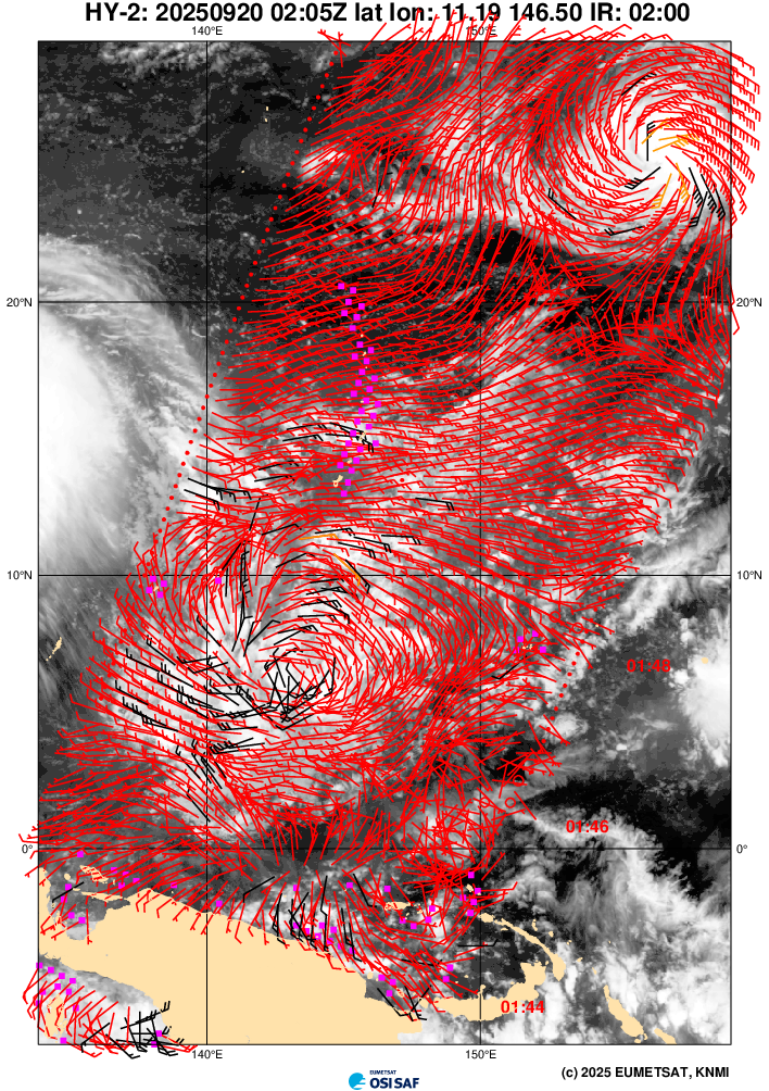
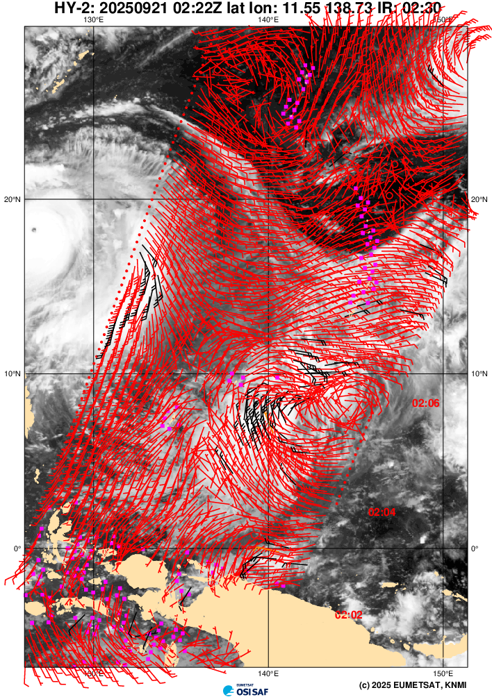
(1) AN AREA OF CONVECTION (INVEST 92W) HAS PERSISTED NEAR 10.4N
139.2E, APPROXIMATELY 82.2 NM NORTHEAST OF YAP. ANIMATED
MULTISPECTRAL IMAGERY (MSI) DEPICTS A DISORGANIZED BROAD AREA OF
FLARING CONVECTION FEATURING MODERATE CONVERGENCE ALONG THE NORTHWEST
PERIPHERY. A 212330Z ASCAT-C PASS SHOWS A BROAD CIRCULATION WITH
STRENGTHENING WINDS ALONG THE NORTHWESTERN PERIPHERY OF THE WEAKLY
DEFINED AREA OF CONVECTION. ENVIRONMENTAL ANALYSIS REVEALS MARGINAL
CONDITIONS FOR DEVELOPMENT WITH HIGH VERTICAL WIND SHEAR (20-25
KNOTS), MODERATE POLEWARD OUTFLOW, AND WARM SEA SURFACE TEMPERATURES.
GLOBAL MODELS INDICATE THAT INVEST 92W WILL HAVE A NORTHWESTWARD
TRACK WITH STEADY DEVELOPMENT WITHIN THE NEXT 24-48 HOURS. MAXIMUM
SUSTAINED SURFACE WINDS ARE ESTIMATED AT 18 TO 23 KNOTS. MINIMUM SEA
LEVEL PRESSURE IS ESTIMATED TO BE NEAR 1008 MB. THE POTENTIAL FOR THE
DEVELOPMENT OF A SIGNIFICANT TROPICAL CYCLONE WITHIN THE NEXT 24
HOURS IS LOW.
(2) NO OTHER SUSPECT AREAS.
C. SUBTROPICAL SYSTEM SUMMARY: NONE.
2. SOUTH PACIFIC AREA (WEST COAST OF SOUTH AMERICA TO 135 EAST):
A. TROPICAL CYCLONE SUMMARY: NONE.
B. TROPICAL DISTURBANCE SUMMARY: NONE.
C. SUBTROPICAL SYSTEM SUMMARY: NONE.//
NNNN
MSGID/GENADMIN/JOINT TYPHOON WRNCEN PEARL HARBOR HI//
SUBJ/SIGNIFICANT TROPICAL WEATHER ADVISORY FOR THE WESTERN AND SOUTH
PACIFIC OCEANS/220600Z-230600ZSEP2025//
REF/A/MSG/JOINT TYPHOON WRNCEN PEARL HARBOR HI/220151ZSEP2025//
REF/B/MSG/JOINT TYPHOON WRNCEN PEARL HARBOR HI/220152ZSEP2025//
NARR/REFS A AND B ARE TROPICAL CYCLONE WARNINGS.//
RMKS/
1. WESTERN NORTH PACIFIC AREA (180 TO MALAY PENINSULA):
A. TROPICAL CYCLONE SUMMARY:
(1) AT 22SEP25 0000Z, SUPER TYPHOON 24W (RAGASA) WAS LOCATED
NEAR 19.3N 122.9E, APPROXIMATELY 520 NM EAST-SOUTHEAST OF HONG KONG,
AND HAD TRACKED WESTWARD AT 12 KNOTS OVER THE PAST SIX HOURS. MAXIMUM
SUSTAINED SURFACE WINDS WERE ESTIMATED AT 145 KNOTS GUSTING TO 175
KNOTS. SEE REF A (WTPN32 PGTW 220300) FOR FURTHER DETAILS.
(2) AT 22SEP25 0000Z, TYPHOON 25W (NEOGURI) WAS LOCATED NEAR
29.7N 151.0E, APPROXIMATELY 367 NM NORTH-NORTHWEST OF MINAMI TORI
SHIMA, AND HAD TRACKED NORTHWARD AT 04 KNOTS OVER THE PAST SIX HOURS.
MAXIMUM SUSTAINED SURFACE WINDS WERE ESTIMATED AT 105 KNOTS GUSTING
TO 130 KNOTS. SEE REF B (WTPN33 PGTW 220300) FOR FURTHER DETAILS.
(3) NO OTHER TROPICAL CYCLONES.
B. TROPICAL DISTURBANCE SUMMARY:
(1) AN AREA OF CONVECTION (INVEST 92W) HAS PERSISTED NEAR 10.4N
139.2E, APPROXIMATELY 82.2 NM NORTHEAST OF YAP. ANIMATED
MULTISPECTRAL IMAGERY (MSI) DEPICTS A DISORGANIZED BROAD AREA OF
FLARING CONVECTION FEATURING MODERATE CONVERGENCE ALONG THE NORTHWEST
PERIPHERY. A 212330Z ASCAT-C PASS SHOWS A BROAD CIRCULATION WITH
STRENGTHENING WINDS ALONG THE NORTHWESTERN PERIPHERY OF THE WEAKLY
DEFINED AREA OF CONVECTION. ENVIRONMENTAL ANALYSIS REVEALS MARGINAL
CONDITIONS FOR DEVELOPMENT WITH HIGH VERTICAL WIND SHEAR (20-25
KNOTS), MODERATE POLEWARD OUTFLOW, AND WARM SEA SURFACE TEMPERATURES.
GLOBAL MODELS INDICATE THAT INVEST 92W WILL HAVE A NORTHWESTWARD
TRACK WITH STEADY DEVELOPMENT WITHIN THE NEXT 24-48 HOURS. MAXIMUM
SUSTAINED SURFACE WINDS ARE ESTIMATED AT 18 TO 23 KNOTS. MINIMUM SEA
LEVEL PRESSURE IS ESTIMATED TO BE NEAR 1008 MB. THE POTENTIAL FOR THE
DEVELOPMENT OF A SIGNIFICANT TROPICAL CYCLONE WITHIN THE NEXT 24
HOURS IS LOW.
(2) NO OTHER SUSPECT AREAS.
C. SUBTROPICAL SYSTEM SUMMARY: NONE.
2. SOUTH PACIFIC AREA (WEST COAST OF SOUTH AMERICA TO 135 EAST):
A. TROPICAL CYCLONE SUMMARY: NONE.
B. TROPICAL DISTURBANCE SUMMARY: NONE.
C. SUBTROPICAL SYSTEM SUMMARY: NONE.//
NNNN
0 likes
ヤンデレ女が寝取られるているのを見たい!!!
ECMWF ensemble NWPAC plots: https://ecmwfensnwpac.imgbb.com/
Multimodel NWPAC plots: https://multimodelnwpac.imgbb.com/
GFS Ensemble NWPAC plots (16 & 35 day forecast): https://gefsnwpac.imgbb.com/
Plots updated automatically
ECMWF ensemble NWPAC plots: https://ecmwfensnwpac.imgbb.com/
Multimodel NWPAC plots: https://multimodelnwpac.imgbb.com/
GFS Ensemble NWPAC plots (16 & 35 day forecast): https://gefsnwpac.imgbb.com/
Plots updated automatically
-
dexterlabio
- Category 5
- Posts: 3521
- Joined: Sat Oct 24, 2009 11:50 pm
Re: WPAC: INVEST 92W
I can see this failing to take off due to the ULL-induced wind shear. Although if the timing and environment is right, once that ULL (and also Ragasa's large outflow) goes out then this potential storm can take advantage and perhaps strengthen quickly.
0 likes
Personal Forecast Disclaimer:
The posts in this forum are NOT official forecast and should not be used as such. They are just the opinion of the poster and may or may not be backed by sound meteorological data. They are NOT endorsed by any professional institution or storm2k.org. For official information, please refer to the NHC and NWS products.
The posts in this forum are NOT official forecast and should not be used as such. They are just the opinion of the poster and may or may not be backed by sound meteorological data. They are NOT endorsed by any professional institution or storm2k.org. For official information, please refer to the NHC and NWS products.
Re: WPAC: INVEST 92W
06z eps, deterministic tracker seems to be weakening it from a TS on approach to land, on other the hand the strongest ensemble initialized Ragasa at 193 kts

0 likes
ヤンデレ女が寝取られるているのを見たい!!!
ECMWF ensemble NWPAC plots: https://ecmwfensnwpac.imgbb.com/
Multimodel NWPAC plots: https://multimodelnwpac.imgbb.com/
GFS Ensemble NWPAC plots (16 & 35 day forecast): https://gefsnwpac.imgbb.com/
Plots updated automatically
ECMWF ensemble NWPAC plots: https://ecmwfensnwpac.imgbb.com/
Multimodel NWPAC plots: https://multimodelnwpac.imgbb.com/
GFS Ensemble NWPAC plots (16 & 35 day forecast): https://gefsnwpac.imgbb.com/
Plots updated automatically
Re: WPAC: INVEST 92W
WWJP27 RJTD 221800
WARNING AND SUMMARY 221800.
WARNING VALID 231800.
WARNING IS UPDATED EVERY 6 HOURS.
TROPICAL DEPRESSION 1006 HPA AT 12N 137E WNW SLOWLY.
WARNING AND SUMMARY 221800.
WARNING VALID 231800.
WARNING IS UPDATED EVERY 6 HOURS.
TROPICAL DEPRESSION 1006 HPA AT 12N 137E WNW SLOWLY.
0 likes
ヤンデレ女が寝取られるているのを見たい!!!
ECMWF ensemble NWPAC plots: https://ecmwfensnwpac.imgbb.com/
Multimodel NWPAC plots: https://multimodelnwpac.imgbb.com/
GFS Ensemble NWPAC plots (16 & 35 day forecast): https://gefsnwpac.imgbb.com/
Plots updated automatically
ECMWF ensemble NWPAC plots: https://ecmwfensnwpac.imgbb.com/
Multimodel NWPAC plots: https://multimodelnwpac.imgbb.com/
GFS Ensemble NWPAC plots (16 & 35 day forecast): https://gefsnwpac.imgbb.com/
Plots updated automatically
Who is online
Users browsing this forum: No registered users and 43 guests